We start this Thursday with temperatures already approaching 80° as of 8am. Highs around 90° look to be common before showers and thunderstorms erupt this afternoon.
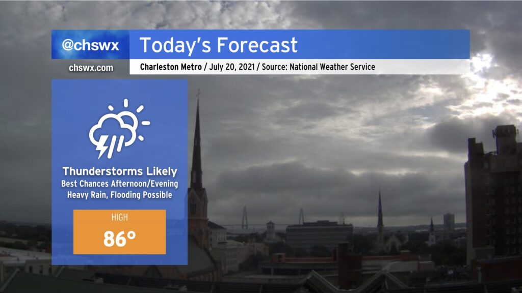
Today’s setup could portend a flooding event in downtown Charleston this afternoon and evening. Westerly winds look to pin the seabreeze closer to the coast, and with a front advancing from the north, there will be numerous focal points for showers and thunderstorms to develop. Atmospheric moisture is readily available, with precipitable water values running over 2″ once again today (anything 2″ or over generally requires more scrutiny for flooding). Finally, we are in a king tide period, and this morning’s thinking from NWS on tonight’s high tide is that it will fall just short of the 7′ level at which sunny-day salt water flooding typically begins. (It may yet be high enough, though, to begin to produce some flooding on Fishburne and Hagood.)
Guidance suggests that showers and thunderstorms generally should start to form between 1-3 PM. Storm motions will approach the coastline today, and with a seabreeze trying to push the opposite direction, this certainly invites concern about heavy rainfall stalling out for a period of time. The high-resolution model ensemble this morning once again paints a 30% chance of 3″ of rain in 3 hours across the metro area this evening, further lending credence to this concern. While this isn’t a slam dunk, it’s important to keep an eye on the weather today as impacts to the evening commute are certainly in the cards. More on this later today — stay tuned.
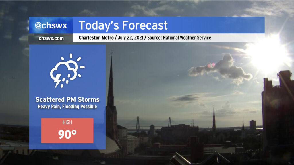
We look to have another wet day ahead, with some showers already popping up west of the Ashley as I write this. The best chance for showers and thunderstorms will again be later this afternoon into this evening. There will once again be a chance for localized heavy rain, with a 30% probability of 3” of rain in 3 hours once again being indicated by the high-resolution ensemble data. Yesterday this bore out in the 17-A corridor headed into College Park, with floodwater on the ground for a few hours after the main rain event. Thus, we are going to need to watch radar trends carefully, noting that high tide will be coming up at 5:39 PM.
Clouds and rain will keep temperatures a few degrees below normal, with highs in the mid-80s expected across the area. A few peeks of sun aren’t out of the question, allowing temperatures in a few spots to perhaps jump quickly. Humidity will still factor in, though, and it’ll feel closer to 94-95° in the afternoon.
Try to stay dry and weather-aware once again today!
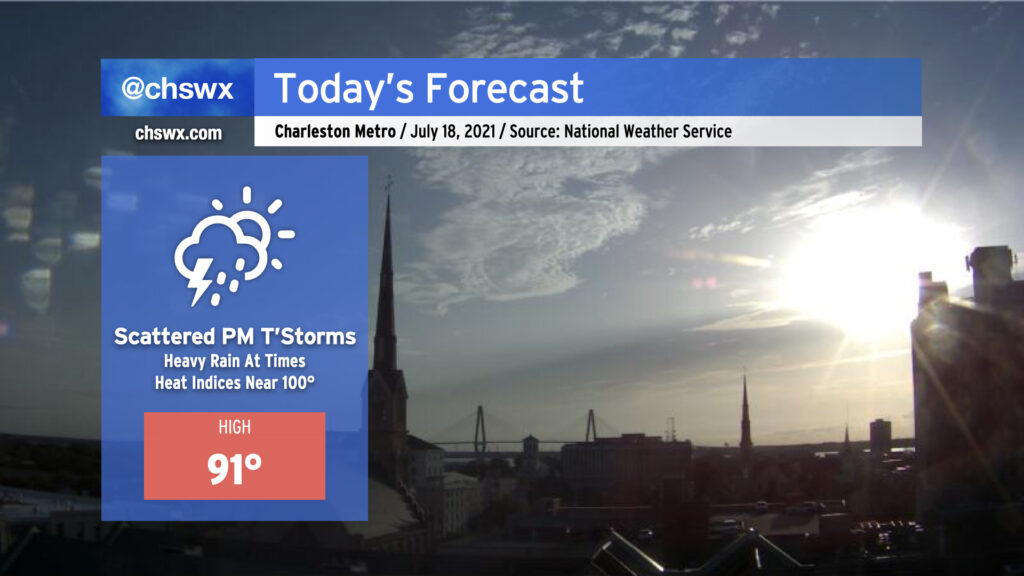
We’re starting today with partly cloudy skies and muggy temperatures in the mid-70s. This will give way to 90s ahead of the seabreeze this afternoon; heat indices will push 100° with low 70s surface dewpoints in place. Showers and thunderstorms will fire on the seabreeze possibly as soon as noon-1pm, which could portend some rainfall or lightning concerns at area beaches early this afternoon. The seabreeze will then make its usual daily inland trek, bringing the risk for showers and thunderstorms more inland with time. This will happen as a mid-level disturbance moves into the area, which will enhance the coverage of showers and thunderstorms today into tonight. Some areas of heavy rain are certainly possible, with the high-resolution model ensemble painting a 10% chance of 3″ of rain in 3 hours across the entire coastal plain. This could lead to isolated bouts of flooding, so we’ll want to watch this closely throughout the day.
Rain chances will continue overnight into Monday, with the risk for heavy rain continuing throughout the day Monday. More on that later today as we get the daytime guidance package in.
We’re in full-blown Command-C/Command-V mode here at @chswx HQ this week, as one would typically expect in a Charleston summer: Highs in the low 90s with isolated afternoon thunderstorms expected. This forecast is right on the dot with mid-July climatology, and there’s really not too much else to write home about.
If you’re headed to the beaches or out on the water this morning, there is the risk of a waterspout underneath any tall cumulus towers, and there will be a persistent rip current risk all day. These are the only caveats — mind these and you’ll be in good shape.
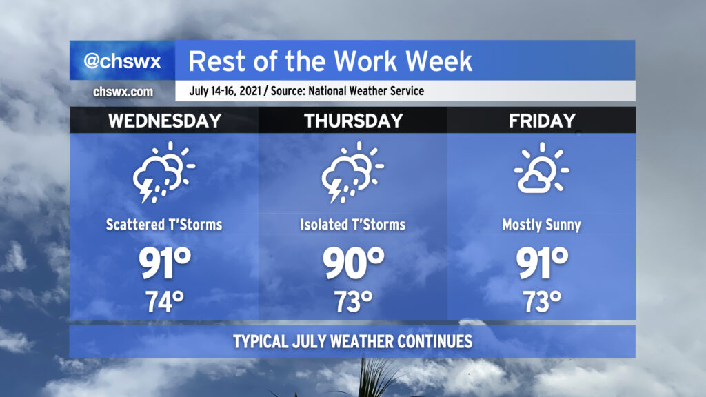
The work week rolls on with pretty standard July weather as we remain under the influence of Atlantic high pressure. We’ll stay warm and muggy with lows in the low to mid-70s away from the coastal communities (where lows likely won’t dip below 80°). Highs each afternoon will continue to top out around 90-91° — right around where we should be for this time of year. Rain chances come down a touch on Friday, with mostly sunny skies currently expected.
Overall, brief heavy rain will be possible within any thunderstorms, though storms today did show a propensity to train a bit, with 2″ of rain recorded at a gauge in Mt. Pleasant within a persistent round of thunderstorms earlier today. The strongest storms could produce sporadic wind damage, but widespread severe weather is not in the forecast by any stretch.
Rain chances stay around normal for July heading into the weekend before ramping up a bit as we get into next week.
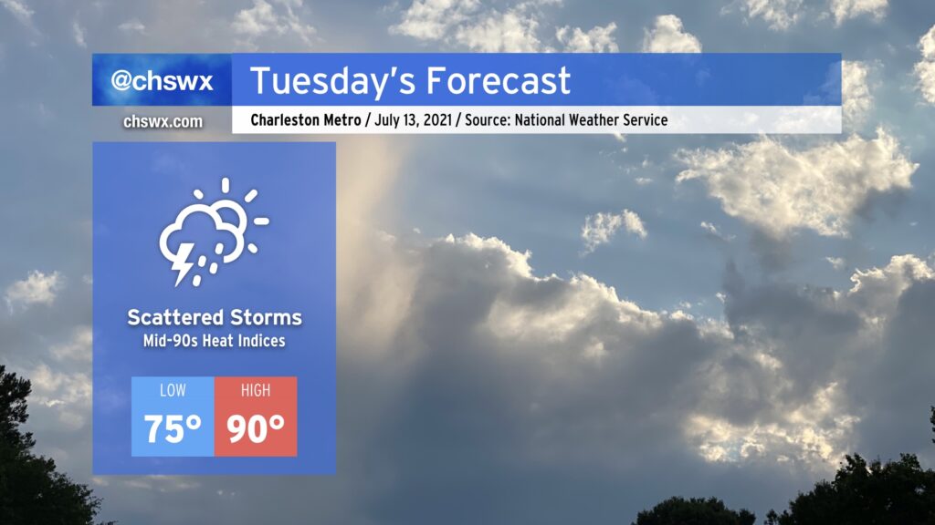
Another rather normal July day is in store for Tuesday. Expect a muggy start with lows in the mid-70s heading toward a high of around 90° in the afternoon. Like today, scattered showers and thunderstorms will factor into the weather picture possibly right out of the gate in the morning near the coast. This scattered storm risk progresses inland during the day with the seabreeze, leaving rain-free conditions in many spots by evening.
Heat indices will peak in the mid-90s in the afternoon, particularly around seabreeze passage as dewpoints surge in its wake, so be aware if you’re working outside around this time.
After a raucous night with Tropical Storm Elsa, we find ourselves in a lull this morning as the storm lifts quickly away to the northeast. Winds are slackening and we are drying out after a very soggy night — 4” is on the low end of rain totals around parts of the Charleston metro area. I’ll discuss more of Elsa’s aftermath later today as damage is assessed and additional rain totals come in.
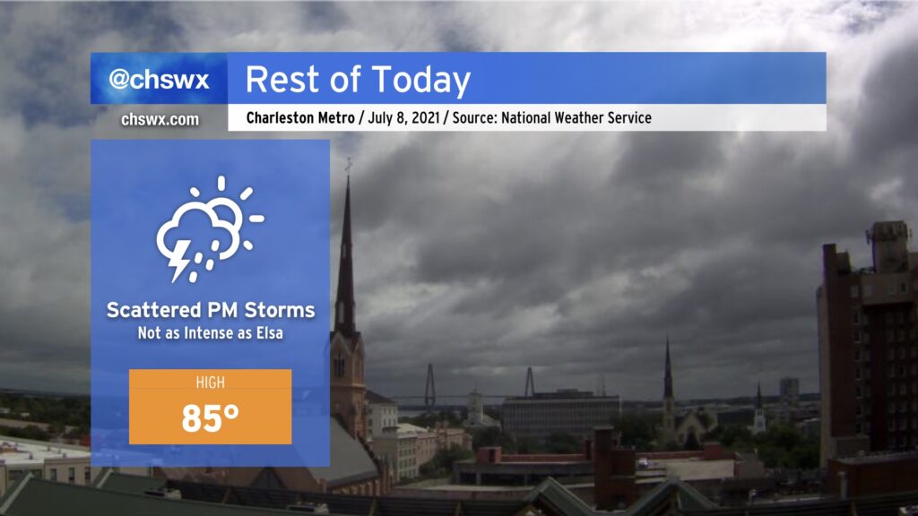
For now, though, we get a bit of a break, but showers and thunderstorms are expected to fire back up this afternoon as a little energy aloft ripples through and induces some additional development with a little daytime heating. The good news is that additional severe weather is not expected. Rainfall amounts should generally be around a quarter-inch.
Highs top out in the mid-80s; the humidity will make it feel in the 90s.
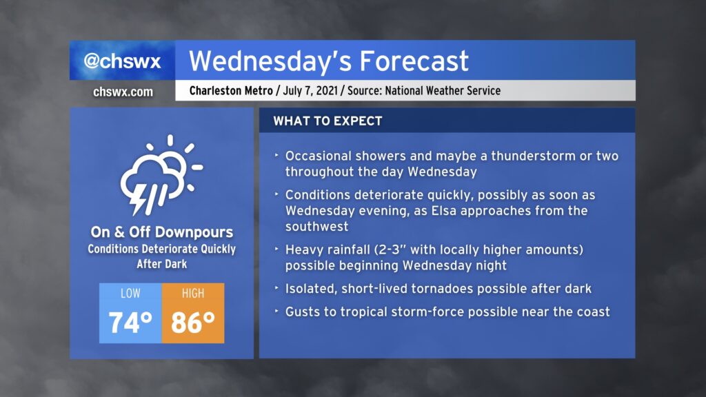
The weather spotlight turns sharply onto Hurricane Elsa as it becomes the primary weather-maker for our neck of the woods through Thursday evening. Based on the current National Hurricane Center track, it looks as if the bulk of the bad weather associated with Elsa will arrive later Wednesday, with periods of very heavy rain being the overwhelming concern through Thursday morning.
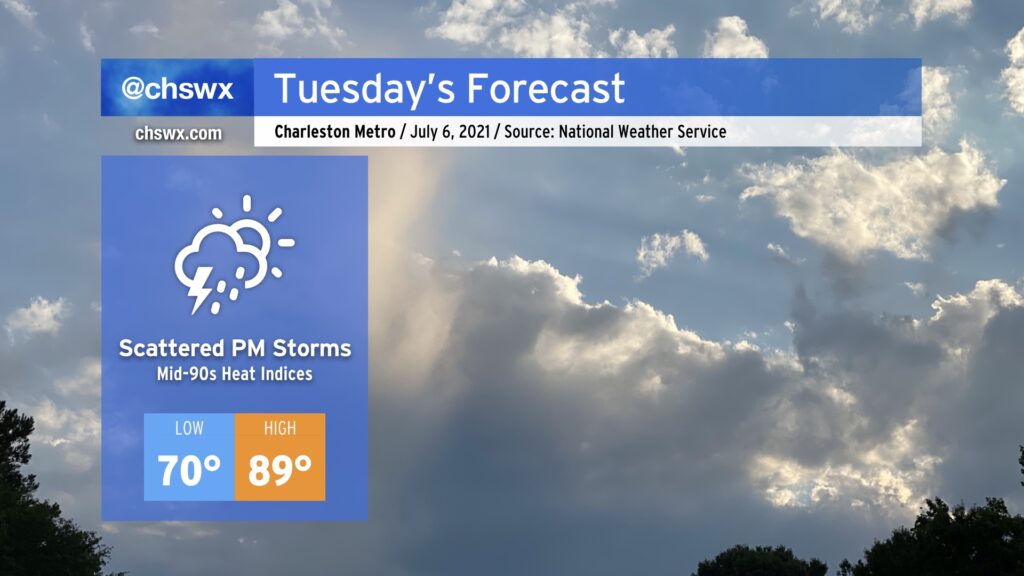
After a remarkably dry Independence Day weekend, we will get back to work and a somewhat more familiar July weather pattern on Tuesday as tropical moisture ahead of Elsa begins to spread northward into the area, enhancing shower and thunderstorm chances in the afternoon. Temperatures will top out in the upper 80s to near 90°, and humidity will push heat indices into the mid-90s. We in #chswx do not expect any direct impacts from Elsa on Tuesday, but it is possible that there will be at least a Tropical Storm Watch put in place by then, so don’t be shocked if one is issued.
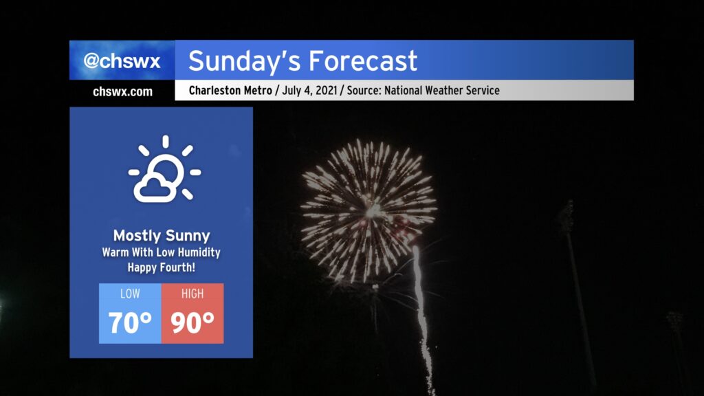
This is going to be one of the better Independence Days for weather in the Lowcountry thanks to an exceedingly rare cold front that came through this morning. Tomorrow will be warm, for sure — highs topping out around 90° away from the beaches — but the humidity (or lack thereof) will be the real story. NWS forecast dewpoints are in the low to mid-60s, which is almost unheard of around here in July. Drier air throughout the atmosphere will keep cloud cover to a minimum, making for a fantastic outdoors day across the Lowcountry. Don’t forget the sunscreen and be safe going to the beach!