We’ve got one more day of scattered to numerous storms inland (we can’t seem to catch a raindrop here toward the coast) before ridging and drier air begins to put a bit of a lid on more widespread thunderstorm activity heading into Thursday and Friday. As storm coverage decreases, temperatures will increase, and we look in line for our first 100° heat indices of the year come Friday. A storm or two will still be possible, which may bring some brief relief, but be ready to pay a little more attention to hydration and time outside later this week.
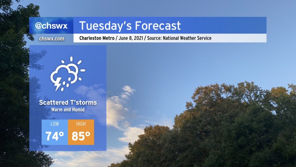
We’ll continue our risk for isolated to scattered showers and thunderstorms overnight Monday into much of Tuesday. Like today, we could see some showers swinging through early in the morning. More scattered showers and storms should pop as daytime heating builds across the area. We’ll see this risk shift inland with the seabreeze by evening. Severe weather is unlikely, but this time of year we always have to be wary of outflow boundaries and their intersection helping to briefly intensify thunderstorm updrafts.
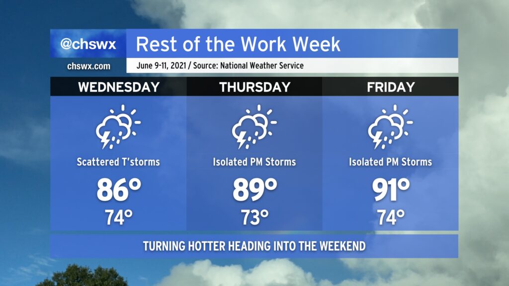
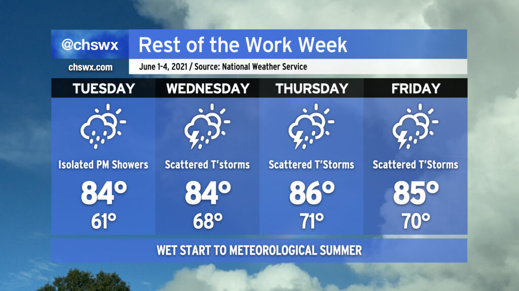
Temperatures will top out in the mid-80s thanks to cloud cover and the presence of scattered showers and storms. The humidity will make it feel more like the low 90s. A warming trend continues throughout the week; we’re in the 90s by Friday.
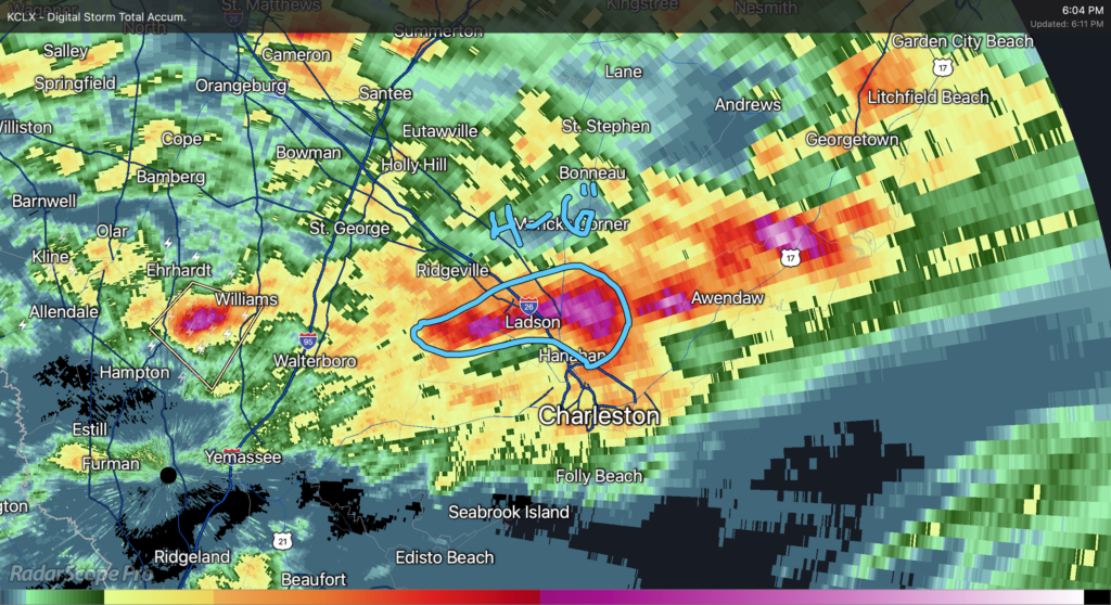
It’s been another rough day of precipitation. Last night, McClellanville and then Downtown Charleston took the brunt of it, and today it was the Goose Creek area. Rain gauges in the Crowfield Plantation/College Park area recorded 4-6″ of rain in just about two hours as strong to severe thunderstorms (which dropped quarter-size hail on Goose Creek) essentially parked themselves until they gusted out.
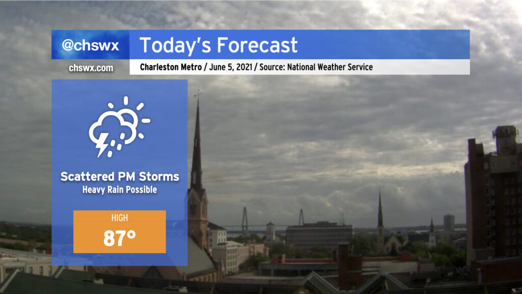
It must be June: Scattered showers and thunderstorms return to today’s forecast with temperatures topping out in the mid-to-upper 80s. Today’s storms look to kick off along the seabreeze perhaps as early as 1-2 PM, with the likeliest corridor of heavy rain to remain between I-95 and US-17. A couple storms could briefly turn severe with wet microbursts the primary concern, particularly where outflow boundaries intersect. So far, overnight model data do not favor a repeat of last night’s deluge in Downtown Charleston, but we will need to see how things ultimately evolve this afternoon. Keep rain gear handy and be ready to move outdoor activities indoors — in other words, pretty much standard for this time of year.
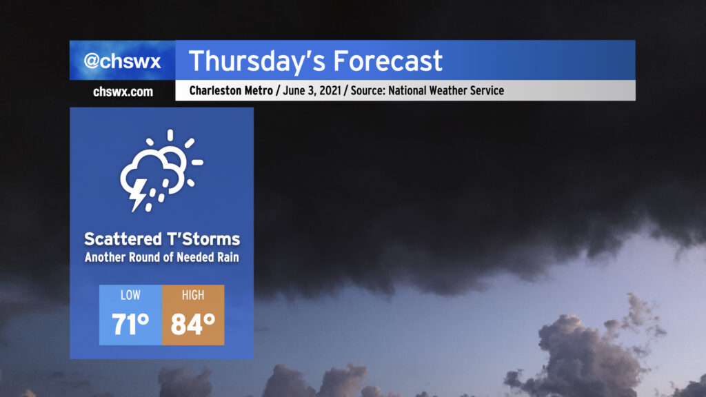
Scattered showers and thunderstorms return to the weather picture on Thursday. We should see a little greater coverage of storms than we saw today given weakening high pressure at the surface and even more robust moisture in place. Temperatures once again will only top out in the mid-80s with showers and storms in the area after a mild start in the 70s. Convective temperatures look fairly low — model soundings generally suggest around 80° — so we should see showers begin to initiate within 2-3 hours of sunrise. Storm motions will be inland, and we should see a break in the rain closer to the coast in the late afternoon/early evening hours as the seabreeze makes its westward progression. With any luck, we’ll get more much-needed rainfall across even more of the area than we saw today.
We’ll have more chances for beneficial rainfall tomorrow across the Lowcountry as scattered showers and even a few thunderstorms will be possible for much of the day. Onshore flow and storms in the area will keep high temperatures down into the low 80s. No severe weather is expected, just more much-needed rain. Not everyone will see rain, and it won’t rain all the time. If you miss out tomorrow, rain chances continue to head up as we get into Thursday and Friday, so chances are good you’ll see something as the pattern turns wetter across the area.
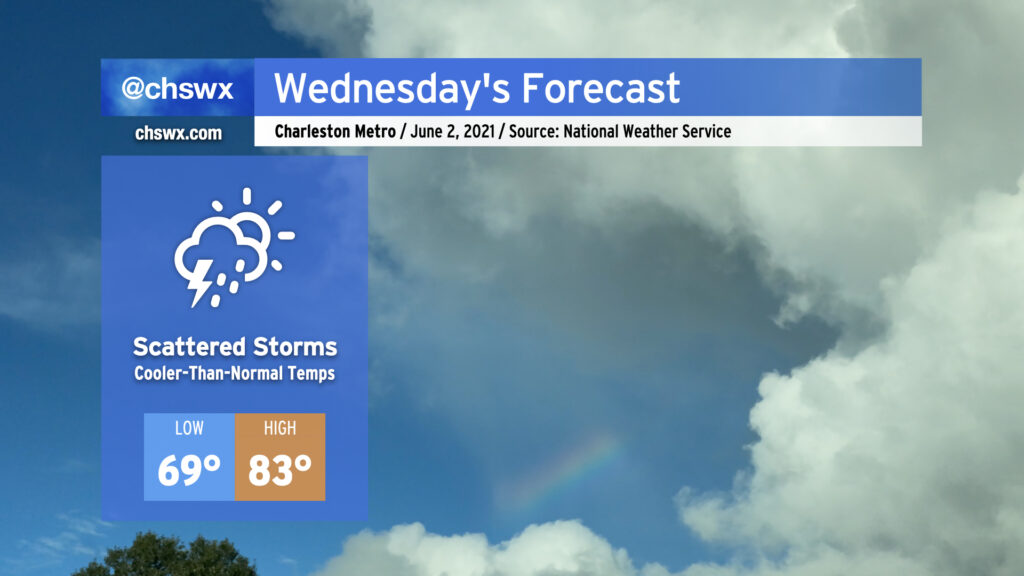
We’ll get June off to an increasingly rainy start as the dry high pressure which brought us two incredible days this weekend begins to break down. Expect to get much of Tuesday in rain-free, but a few showers will be possible in the afternoon and evening hours as a coastal trough begins to sharpen nearby and moisture begins to peek ashore. As we get into Wednesday, more moisture will overspread the area and shower and storm coverage will kick up a little bit. We’ll see this pattern persist into Thursday and Friday, with afternoon showers and storms becoming more likely each day, bringing some more much-needed rainfall to the area. If you didn’t get much with Saturday evening’s activity, you’ll more likely than not have some measurable rainfall by the end of the week.
High temperatures will remain at or ever-so-slightly below normal through the work week thanks to onshore flow and expected afternoon showers and thunderstorms. Lows will be creeping back toward 70° with the increasingly humid airmass in place. With June 1 marking the beginning of meteorological summer, it will be as if the humidity will be right on cue.
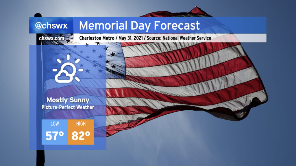
We will commemorate Memorial Day and close out May with picture-perfect weather. Lows will run 5-10° below normal away from the immediate coast, warming nicely into the low 80s under mostly sunny skies as high pressure remains in control over the Southeast. Onshore flow will keep temperatures cooler closer to the coast, with upper 70s likely as high as we get there. Humidity will be comfortable with dewpoints in the mid-50s, too. As we know, this is increasingly rare air for this time of year, so be sure to take advantage as the rest of the work week turns a little warmer and increasingly unsettled.
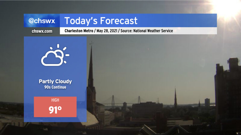
We’ll be back in the 90s today — perhaps for the last day for a little while — as the lingering effects of high pressure aloft remain for one more day before a front moves into the area on Saturday. Unlike yesterday, an earlier seabreeze progression will keep highs capped around 90-91°. (Yesterday’s high was 94°, tying Monday for warmest so far in 2021.) A shower or two can’t be totally ruled out as the seabreeze progresses inland, but with dry air remaining in place for one more day, coverage will be limited.
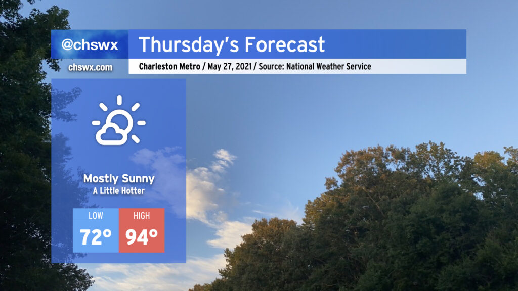
We’ll see a little more sunshine tomorrow, and that’ll add a little more heat to the forecast as a result. Temperatures will top out in the mid-90s away from the immediate coast on Thursday with winds out of the southwest turning more southerly as the seabreeze moves inland later in the day. A popup shower or two ahead of the seabreeze cannot be discounted, but the vast, vast majority of us continue our rain-free streak. We’ll see more shower and storm chances come into the picture over the weekend — hang in there, lawns and gardens.