Sunday will finish with a little more warmth than we’ve had the last couple days as high pressure slips offshore and a front stalls out nearby. Clouds will be on the increase throughout the day, but rainfall is expected to hold off until overnight. Highs will top out in the mid-80s; with dewpoints in the 60s, this will feel a little warmer and more humid than we felt on Saturday.
The second half of 2019 will get off to a fairly hot start, with heat indices running in the low 100s each afternoon. Scattered thunderstorms will provide relief, particularly later in the week. (Must be July in Charleston.)
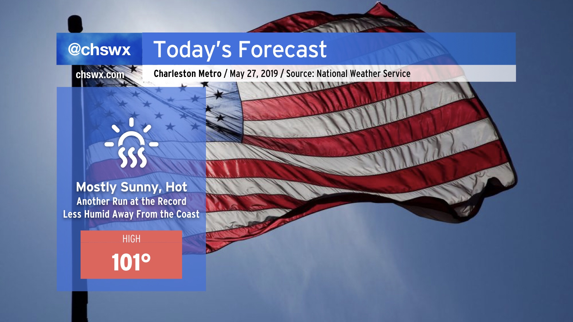
We will make another run at the century mark today, with a decent chance of at least tying the all-time May high temperature record set yesterday (100°). In fact, this morning’s NWS forecast has the airport breaking that record once again today. While there is no Heat Advisory today as heat indices will remain below 105° (pre-July 1 threshold), it will still be plenty hot (even at the beaches, where low 90s are possible) and you should still keep heat safety precautions in mind when observing Memorial Day today.
Today is day one of a potentially long-duration, early-season heat wave that will continue into at least next week. Record heat is forecast today, with a high of 98° expected. If this verifies, this would break the record of 97° set in 1953. Air conditioning is best today (and for the next several days), but if you must be outside, take frequent breaks, drink lots of water, and seek shade regularly.
Today is the “calm before the warm” as the pattern begins to kick into place for a significant, long-duration heat wave starting tomorrow. (More on that later today.) A shower or storm can’t be ruled out early today, but as the ridge builds, clouds will decrease. The vast majority of us remain bone dry. Temperatures will range from the upper 80s in the Charleston metro to the low 90s closer to I-95.
We’ve got another dry and seasonably warm spring day ahead. Temperatures will top out in the low 80s under partly cloudy skies; onshore flow will aid the seabreeze in punching through the area this afternoon, which will keep temperatures in check. A shower or two can’t be totally ruled out along and ahead of the seabreeze this afternoon, mainly inland from the coast.
Drought continues over the Lowcountry as we head into the first full week of May. Some of you got some decent rainfall this weekend, but for many of us, just a few showers fell. (I got a grand total of 0.05″ on Saturday and Sunday, the first measurable rainfall since April 20.) Moderate drought conditions continue, with mostly dry weather (save for the potential for a thunderstorm this afternoon) expected through Wednesday.
High pressure remains in control of the forecast through Thursday, yielding several quiet weather days. (That sound you hear is the collective sigh of lots of Charleston-area meteorologists who spent much of Friday doing battle with spin-up tornadoes.)
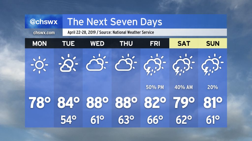
We’ll maintain seasonable conditions through Tuesday as high pressure gradually slips offshore. Southerly flow around the back side of the high turns on the heat pump for Wednesday and Thursday, with highs expected to top out in the upper 80s for the first time this year. A cold front will then approach on Friday, bringing a chance for showers and thunderstorms to the area. Some chance of rain lingers through the weekend, but it’s nothing to toss your plans over.
More drought relief is on the way for Monday as energy from a storm system makes its approach to the Lowcountry. This beneficial rain may come with a few strong wind gusts, though.
Tuesday may be one of the busier weather days we’ve had so far in 2019 as low pressure is expected to brush the coast with strong, gusty winds and a bout of heavy (yet much-needed) rainfall. This may have impacts on the morning commute.