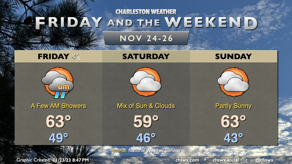
We’ll get Black Friday off to a bit of a cloudy and perhaps showery start as a disturbance ripples through the area, kicking up some patchy rains for a few hours Friday morning. From there, rain will depart and clouds will gradually break some, and we should end the day with some sunshine. We start Friday in the upper 40s and warm to the low 60s.
High pressure wedging southward will keep Saturday on the cool side under a mix of sun and clouds. Temperatures start in the mid-40s but may not crack 60° in the afternoon given the cool high pressure wedging into place. Sunday will represent the coolest start of the set with lows in the low 40s expected. However, we’ll warm to the low 60s in the afternoon as the wedge begins to weaken in advance of another disturbance for Monday. Still, high temperatures will run on the cool side of normal, so sweaters may be advisable.
Coastal flooding could be an issue Saturday and Sunday mornings. Water levels around the 6am high tide Saturday could reach 7.2′, while moderate coastal flooding is possible with Sunday morning’s 6:46am high tide as water levels could peak between 7.6-7.8′. We’re approaching a full moon on Monday, but the bigger driver of coastal flooding will be NE winds kicking up near the coast thanks to a pressure gradient between high pressure building in over land and low pressure spinning up offshore. Stay tuned for possible Coastal Flood Advisories from the National Weather Service.
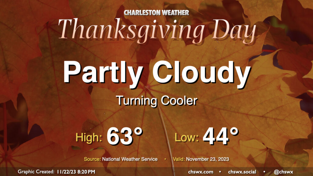
After some much-needed rain Tuesday and Wednesday, we get a day to dry out on Thanksgiving. Expect plenty of sunshine for much of the day (albeit with clouds increasing late) and some cooler and drier air as well — we’ll wake up to lows in the mid-40s that will yield to highs in the low 60s as generally light north winds blow in. Overall, it looks like a great day to get together with family for food and football, amongst other things.
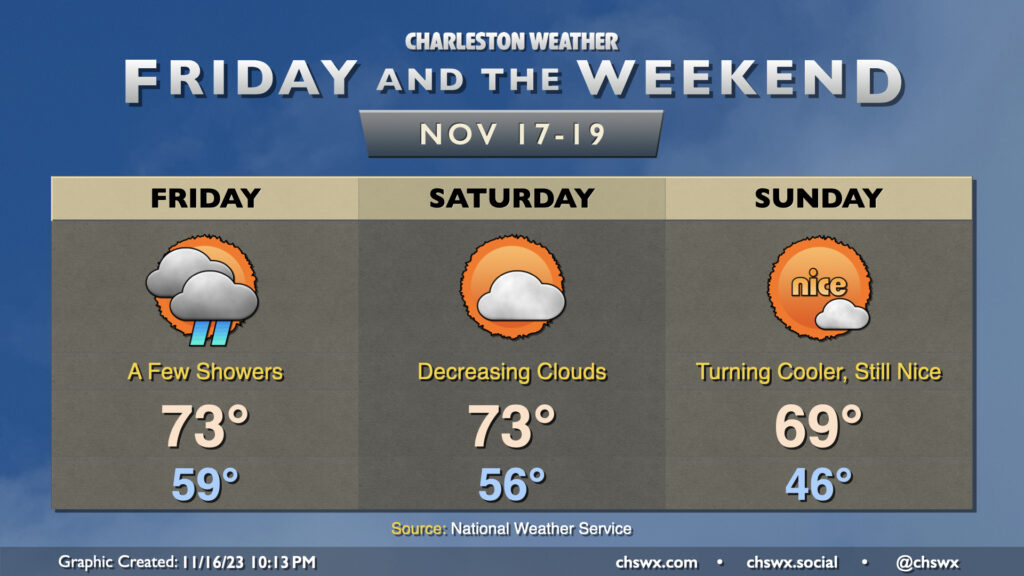
Showers will gradually depart as Friday wears on thanks to low pressure moving away from the area. It’ll be an unseasonably warm day, with lows starting near 60° before temperatures top out in the low to mid-70s in the afternoon. We’ll see some breaks in the clouds between showers, so once again, we’re not expecting a totally gray, washed out day. The only other issue will be the potential for some minor salt water flooding around the 10:25am high tide; expect water levels to peak around 7′ or so, putting some salt water once again on Hagood at Fishburne and perhaps on Lockwood. Widespread flooding issues are not expected.
The weather improves just in time for the weekend. Clouds will be decreasing Saturday as deeper moisture departs. We start the day in the mid-50s before warming into the low 70s in the early afternoon. From there, a cold front will get through later in the day; expect a dry passage thanks to much drier air in place. Sunday will be noticeably cooler — expect lows in the mid-40s, some 10° cooler than Saturday morning — before warming to around 70° in the afternoon.
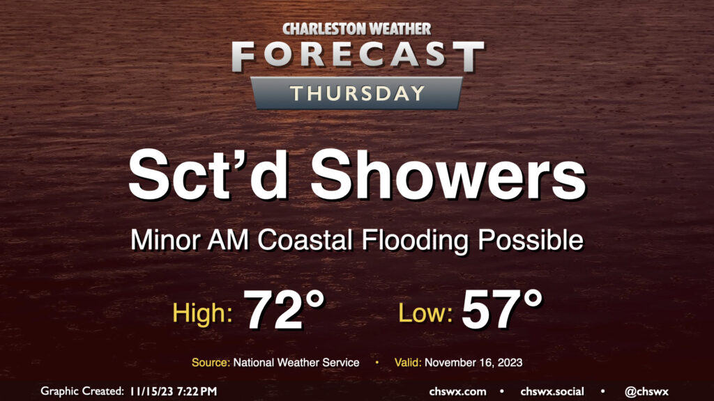
This week’s shower chances will peak Thursday as a disturbance moves across the Gulf Coast, spawning low pressure off the Florida coast. Expect shower activity to generally be scattered in nature, though, with some dry periods and maybe a few breaks in the clouds possible at times. Warmer air will make inroads as the wedge of high pressure which kept temperatures fairly well suppressed over the past few days begins to give way. Expect highs to top out in the low 70s in the afternoon as a result.
There will again be the risk for some minor coastal flooding with Thursday morning’s high tide, which is expected to peak around 9:33am. Much like Wednesday morning, water levels should reach 7-7.2′ again, which should be enough to put some salt water on the roads but not enough to begin to introduce widespread issues. Still, the vulnerable locations on the west side of the peninsula near The Citadel and Gadsden Green will likely take on salt water once again during the morning. Be ready to reroute around flooded roads.
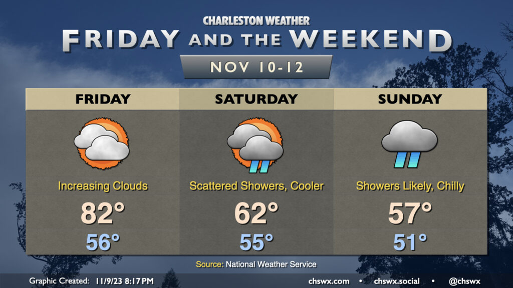
If you’ve been a fan of this recent warm weather, soak Friday in, because that’s going to do it for the 80s for a little while. Clouds will be increasing ahead of a cold front that will be moving by late Friday night, which will usher in a much cooler airmass for the weekend and beyond.
Cool high pressure will wedge southward overnight Friday into Saturday, and we’re going to feel it in the way of lows that’ll run ~20° cooler than what’s expected Friday (low 60s vs. low 80s). Overrunning moisture atop the wedge could bring some showers to the area for Saturday, especially later in the day. The better chance of showers will arrive with a round of mid-level energy that’ll move by Sunday. The expected clouds and showers will keep highs suppressed to the upper 50s at best. We’ll also need to keep an eye on Sunday morning’s high tide for the potential for minor coastal flooding thanks to the northeasterly winds driving up tidal departures.
Overall, it’ll be good to get our first measurable rain of the month as abnormally dry conditions continue to spread across the Lowcountry, even if the weekend is not an ideal time. We’ll see rain taper off later Sunday and some more sunshine as we get into Monday and beyond, though temperatures will remain generally below normal for this point in the year with highs in the mid-60s each afternoon.
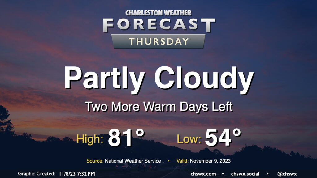
After narrowly missing a record high on Wednesday (the high was 84°, which approached the record of 85° set in 1986), we have another warm day on tap for Thursday. We start the day in the mid-50s before temperatures head to the low 80s in the afternoon under partly cloudy skies — yet another rain-free day as we start November. The rain-free streak looks to come to an end this weekend, though, as a cold front moves by and high pressure wedges southward.
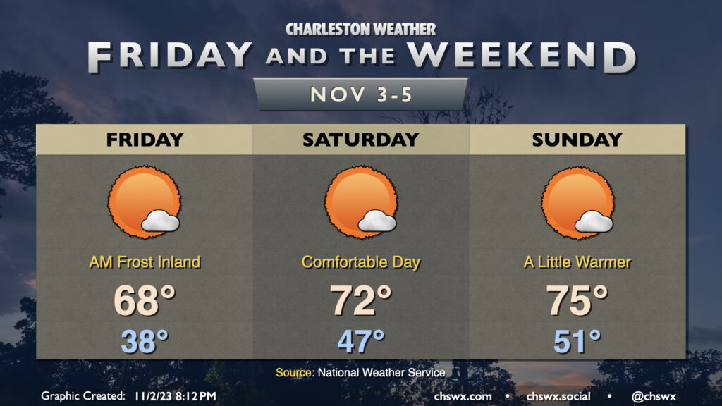
We’ll get Friday off to a slightly frosty start in some parts away from the coast as lows dip into the 30s once again with a little bit more moisture to work with and a little less in the way of wind (though wind chills could still dip into the low 30s). A Frost Advisory is in effect for inland Berkeley and Dorchester for Friday morning where the risk for frost will be greatest, so ensure you’ve got sensitive plants covered just in case. From there, though, we’ll warm into the upper 60s in the afternoon (and 70° might not be totally out of the question, either) under mostly sunny skies.
The warming trend continues Saturday. We start the day in the mid-to-upper-40s — almost ten degrees warmer than Friday. Highs should get into the low 70s under mostly sunny skies — a very nice day to get outside, it looks like.
We turn even a little warmer for Sunday. Expect Sunday to start out around 50-51° or so, warming to the mid-70s in the afternoon. A few clouds will dot the skies from time to time, but it’ll be another day of brilliant sunshine.
We’ll be getting that sunshine in an hour earlier than Saturday, though, as Daylight Saving Time ends at 2am Sunday, sending us back into Eastern Standard Time (UTC-5). The sun will rise around 6:40am, but will set just shy of 5:30pm. Be sure to set clocks needing manual changes back an hour Saturday night. It’s a good time to change batteries in your weather radios and smoke detectors as well.
Thursday gets off to the coldest start since March with lows expected in the mid-30s across much of the metro area. Further inland and in more sheltered locations, it’s quite possible that we’re going to see temperatures fall below freezing. A Freeze Warning is in effect for inland Berkeley and Dorchester for Thursday morning; be sure you’re protecting plants and pets. Add in winds around 5-10 MPH, and we’re talking wind chills in the 20s in many spots. Dress appropriately as you head out tomorrow morning!
From there, temperatures will head to the low 60s in the afternoon despite mostly sunny skies. It’ll ultimately be yet another sweater-worthy day across the area with a continued north to northeasterly breeze.
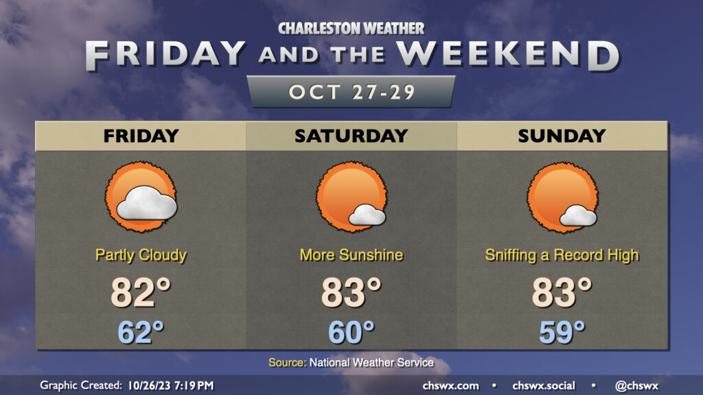
Warm weather continues for Friday and the weekend, feeling a lot more like September than late October. Temperatures will continue to run in the low 80s each afternoon after starts in the low 60s each day. Unsurprisingly, these temperatures run well above climatology. At this point in October, a normal day starts in the low 50s, and we will run well above that through the end of the month, it looks like. Our high temperatures will come in about 8-9° or so above normal each day; we should be in the mid-70s. While the record highs for Friday and Saturday seem out of reach (87° and 86°, respectively), Sunday’s forecast high of 83° comes within a couple degrees of the daily record high of 85° set in 1946.
Fall fans, do not fret, though: A strong cold front appears timed for Halloween. This front will knock temperatures back to near normal for Tuesday, followed by below-normal high temperatures as we start November (think mid-60s vs. mid-70s).
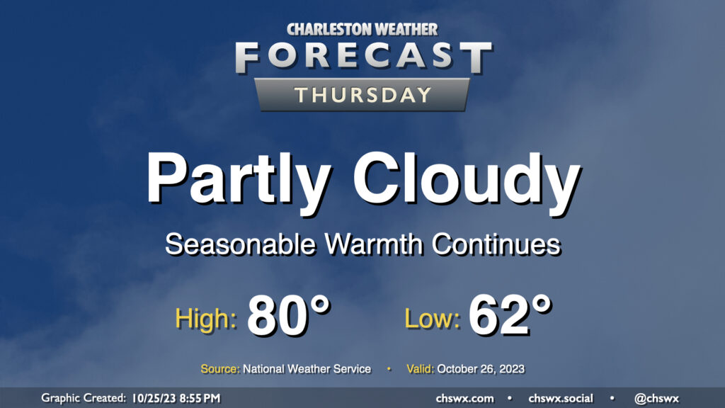
Rinse and repeat: More quiet and warm weather is on tap for Thursday (and beyond!) High pressure remains in control, and that’ll keep things rain-free and rather warm for late October. We start the day in the low 60s (for reference, the normal low for October 26 is 54°) and warm to around 80° in the afternoon. Much like Wednesday, we’ll see a few clouds amongst otherwise blue skies.
The only fly in the ointment will be the potential for some minor coastal flooding with the Thursday evening high tide. Water levels should peak between 7-7.2′ in the harbor, and this’ll cause some salt water to spill onto the typical trouble spots roughly an hour or two on either side of the 6:49 PM high tide. We’ll probably land a Coastal Flood Advisory during Thursday evening’s commute, so be ready to route around a little salt water especially around the Citadel and MUSC.