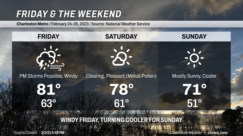
Friday & the weekend: Windy Friday, clearing Saturday, cooler Sunday
Changes are coming in the forecast as we get through the weekend as the abnormal warmth for this point in the year finally starts to get blunted a bit.
Read more »Changes are coming in the forecast as we get through the weekend as the abnormal warmth for this point in the year finally starts to get blunted a bit.
Read more »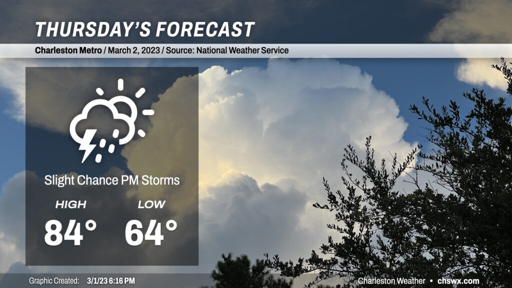
We had another record warm day in the Lowcountry today. The high at the airport reached 86°, breaking the record of 83° set in 2017. Despite the seabreeze making more of an inroads today, Downtown Charleston appears to have tied its record high as well, topping out at 79° to match the mark on March 1, 1918.
We will have one more day of record-challenging temperatures on Thursday before some of the extreme warmth begins to subside. Highs should top out once again in the mid-80s, getting within spitting distance of the record high of 85° set in 1997. This is despite some additional cloud cover and perhaps a few showers and maybe a thunderstorm in the afternoon and evening hours as southwesterly winds ahead of a cold front continue to strengthen across the area. Most of us will get the day in rain-free, though, with the better risk of showers and storms to our north near a frontal boundary. (This might or might not be such a great thing considering the absolute onslaught of pollen that continues across the Lowcountry!)
Read more »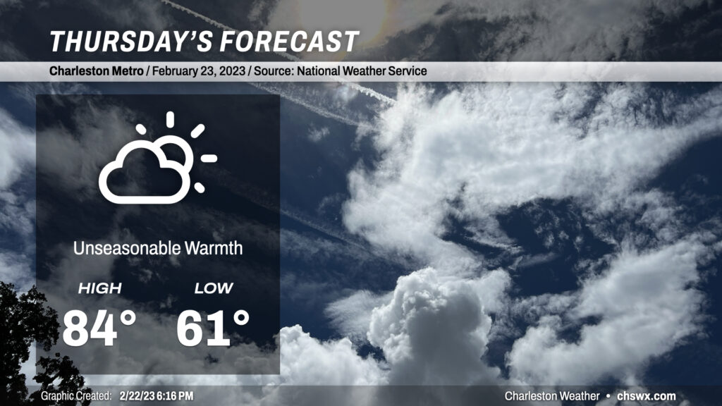
Our warm spell peaks on Thursday on the heels of a second consecutive day where we’ve at least tied the record high. Temperatures will soar into the mid-80s, getting within striking distance of the record high of 86° set just last year. We’ll see a few more clouds ahead of an approaching backdoor cold front, but we look to remain rain-free for one more day.
Read more »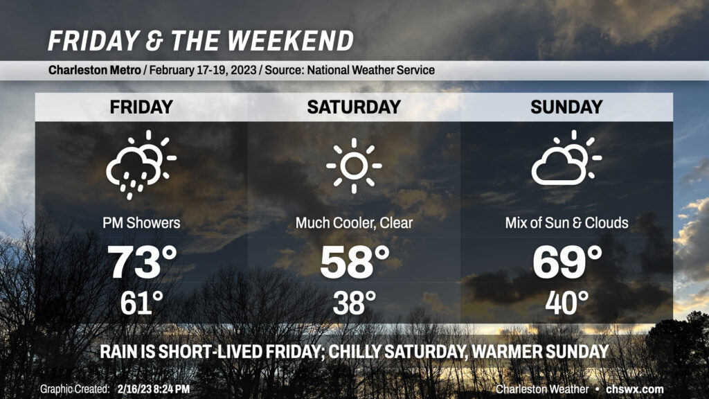
The bad news is that we’re going to see some rain on Friday (probably midday through mid-afternoon). The good news is that it will be short-lived, and that we will have a rain-free weekend for the first time since the first weekend of 2023!
Read more »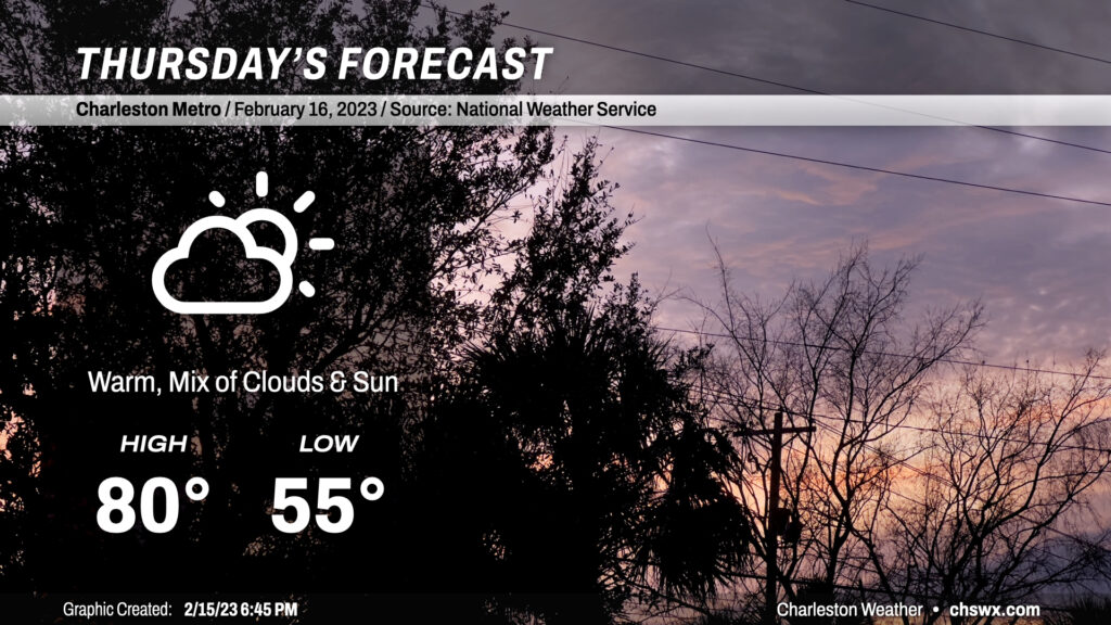
Temperatures topped out close to 80° today in the Lowcountry, and we should meet or even slightly exceed that for Thursday despite a little more cloud cover ahead of Friday’s cold front. We start the day quite mild for mid-February (mid-50s) before soaring to around 80° in the afternoon. Certainly a short-sleeve day for a majority of the day; you’ll shed that light jacket quite early on, methinks.
Read more »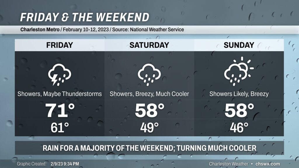
The weather takes a turn for the unsettled starting tomorrow as a cold front approaches the area from the west. We get one more day in the 70s ahead of this front, but plenty of showers are expected within a solid moisture feed from the Gulf, with the better rain chances arriving in the afternoon. A few thunderstorms can’t be ruled out if instability can materialize particularly later in the afternoon and into the evening, and the wind fields are such that a few stronger storms are possible.
A deep trough coming along with the front will slow down and cut off into an upper low. This is going to help keep the weather quite unsettled into the weekend, particularly Saturday as low pressure develops off the coast. Temperatures will drop into the 50s on Saturday and won’t rise terribly much as the upper low pivots overhead and showers stay in the picture. We stay quite chilly on Sunday as low pressure begins to move northeast, and showers will remain likely for much of the day. Highs top out in the upper 50s.
All in all, this is a weekend best experienced indoors. At least there’s going to be a reasonably super football game on Sunday.
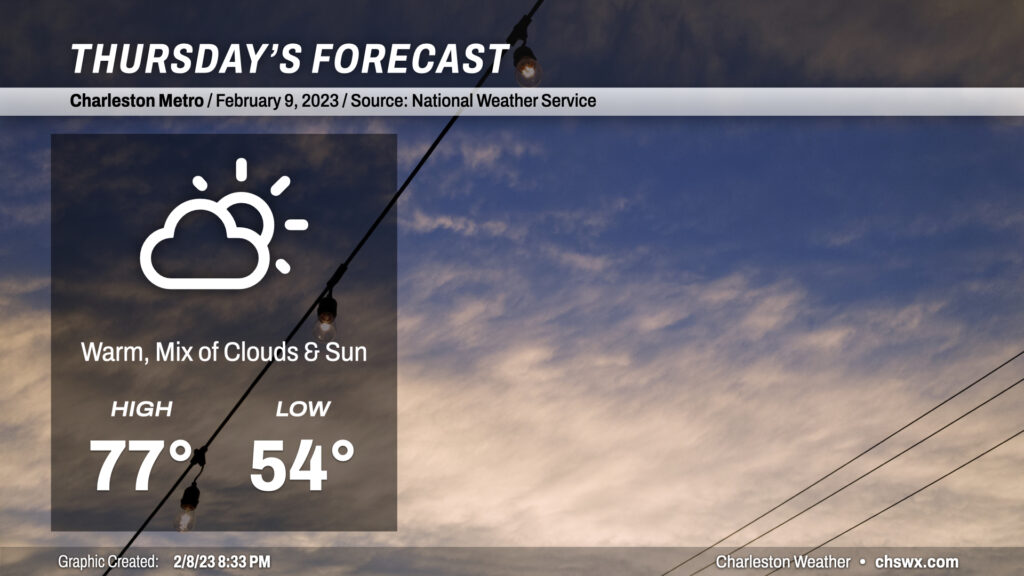
Thursday will be another warm day across the Lowcountry. We’ll start the day with mid-50s and some patches of fog. Heading into the afternoon, highs will top out in the mid-to-upper 70s once again despite more cloud cover than we saw on Wednesday. South winds will be a touch on the breezy side as well. We should get the day in rain-free across much of the area. There’s a small chance that a shower or two could brush the coast in the afternoon, but the bulk of the rain stays away until overnight Thursday into Friday.
Read more »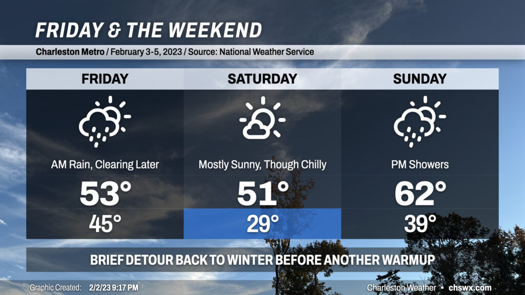
Showers overnight will continue into Friday morning before tapering off in the afternoon. We could see some peeks of sun before Friday’s all said and done, which would be helpful given that highs are only expected to top out in the low 50s. We stay chilly heading into Saturday, with lows in the upper 20s expected across the metro in the morning before temperatures only rebound into the low 50s despite mostly sunny skies. We turn warmer Sunday with highs in the low 60s, but shower chances return in the afternoon as a coastal trough/front sharpens. Overall, if you can deal with some chilly air, Saturday is your best outdoors day, though Sunday morning into early afternoon should be pretty good as well.
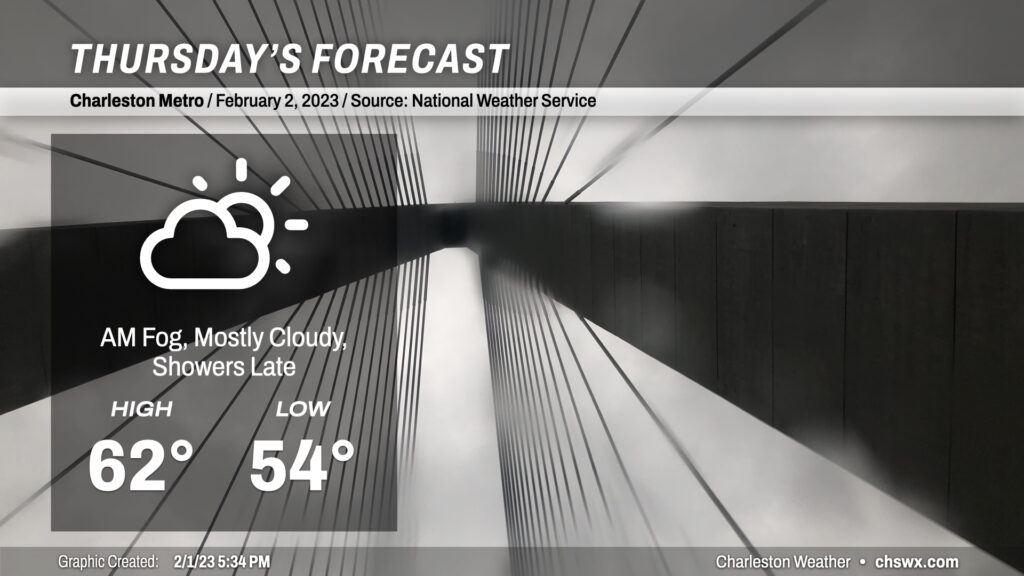
After a record high downtown (77°, breaking the record of 76° set in 1916 and tied in 1950) and just falling short at the airport (81°), temperatures are turning significantly cooler across the area as a wedge front sinks southward tonight. This will result in mostly cloudy conditions for Thursday, with highs running almost 20° below where they did today. Expect some showers to creep back into the area later in the day, with better rain chances settling in overnight into Friday. (Let’s just hope we don’t get caught in a temporal loop on this Groundhog Day.)
Read more »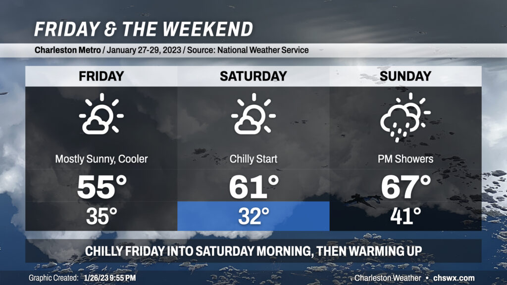
Cool weather will kick off Friday and the weekend as we sit under the influence of high pressure for a couple days before it shuffles back offshore later Saturday into Sunday. Expect lows in the mid-30s on Friday before warming just into the mid-50s despite plenty of sunshine; this is due to a trough axis in the mid-levels passing by to the north. We’ll see this feature give way to more zonal (west-to-east) flow as we get into Saturday, which will start around freezing but will rebound into the low 60s as high pressure begins to move east of the area. Temperatures — and dewpoints — then climb quickly on Sunday ahead of a storm system that’ll kick off rain showers in the afternoon, with the best chances for rain arriving late Sunday into Monday. Highs on Sunday should top out in the mid-to-upper 60s, foretelling a fairly warm end to January with highs next week approaching the 70° mark to close out the first month of 2023.