I hope everyone had a great Thanksgiving Day! The next few days will be a “sunshine sandwich” — overcast and rain, followed by mostly sunny skies, followed by another round of overcast and rain. We will also continue to contend with coastal flooding with the morning high tides through Sunday.
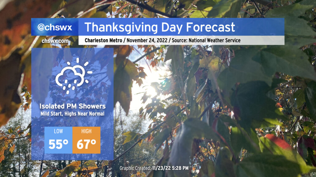
We have a relatively mild Thanksgiving Day ahead as temperatures start in the mid-50s, about 10° above normal for this point in the year. Pesky cloud cover will remain pesky with the coastal trough lingering offshore, and a few showers will be possible before rain chances increase further after sunset as more moisture makes its way ashore. Overall, don’t be surprised to dodge a shower or two, but I suspect that a lot of us get a majority of Thanksgiving in rain-free.
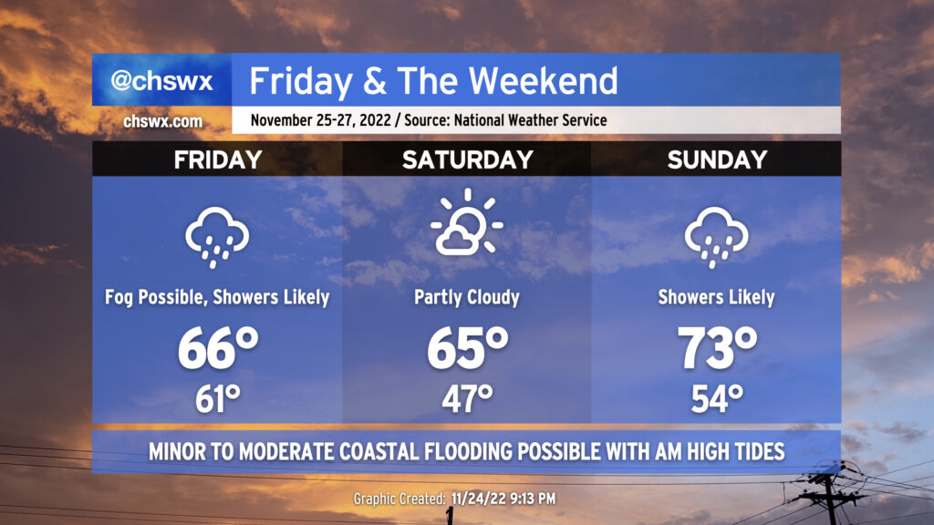
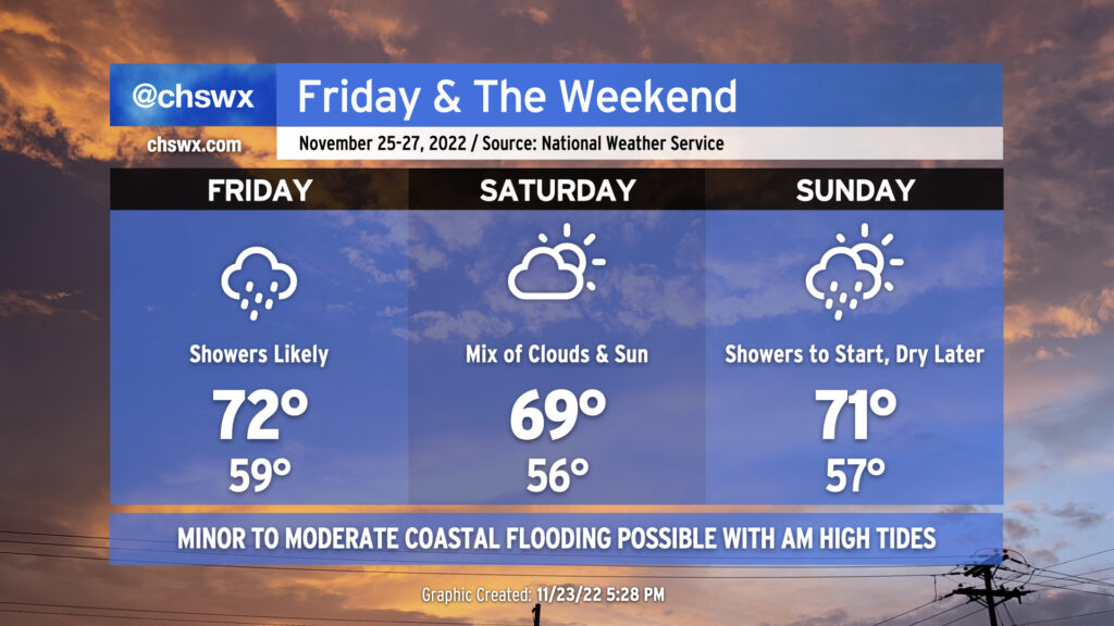
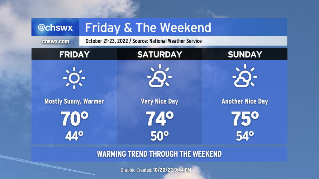
Friday & the weekend: Periods of showers with a nice day in the middle
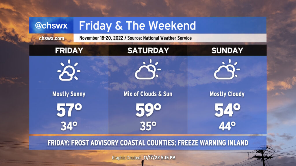
Shower chances will peak on Friday as a warm front moves by followed by a cold front moving in from the north overnight. Lows will approach 15° above normal with cloud cover and a moist airmass in place. The warm front will help temperatures reach the low 70s in the afternoon despite shower activity that’s expected to be in the area. (A thunderstorm can’t be ruled out, either.) These showers will work their way out of here overnight with the aforementioned cold frontal passage.
Saturday should remain mostly dry with a mix of clouds and sun remaining in place. Temperatures will once again bottom out around 10°+ degrees above normal for another mild start followed by highs running right around 70° in the afternoon.
Showers return to the forecast Sunday as another cold front moves by the area. Once again, highs in the low 70s will follow a seasonably mild start to the day in the mid-50s. We should see showers begin to decrease later in the afternoon, paving the way for a cooler, drier, and sunnier Monday.
Coastal flooding remains a concern with morning high tides
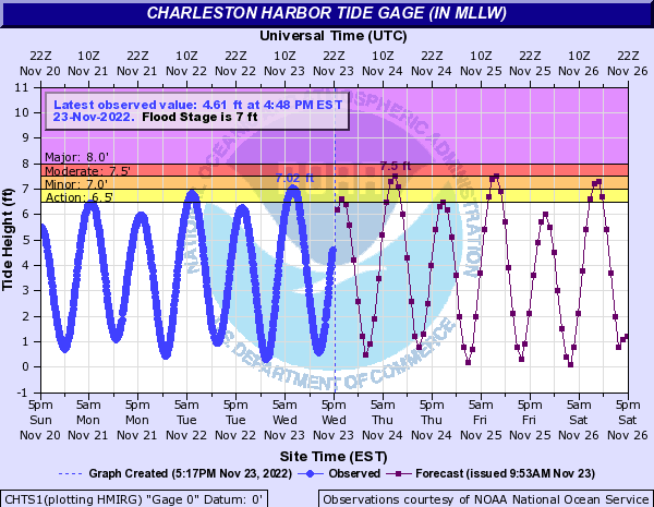
This morning’s high tide peaked around 7.02′, which scraped minor coastal flooding thresholds. Expect additional rounds of minor to moderate salt water flooding around times of the morning’s high tide through Thanksgiving and the long weekend. High tide on Thanksgiving morning is forecast to peak around 7.5′, or moderate flood stage, around 7:43am. We should see similar results from Friday morning’s high tide which is predicted to peak around 8:34am. Minor coastal flooding is forecast for Saturday morning’s 9:29am high tide, while guidance indicates another round of flooding will be possible for Sunday morning’s 10:28am high tide. Stay tuned for Coastal Flood Advisories from the National Weather Service.
We’ve got another chilly weekend ahead, and this time some frosty conditions are expected. Skies will clear tonight, and with light to calm winds expected, solid radiational cooling conditions are probable, allowing temperatures to fall into the mid-30s across much of the metro. This could prompt frost issues in Charleston proper, while places such as Dorchester and inland Berkeley may see a freeze. Thus, a Freeze Warning is up for early Friday morning for inland Berkeley and Dorchester, and a Frost Advisory is in effect for Charleston and tidal Berkeley (Daniel Island, Cainhoy). Be ready to protect plants and pets!
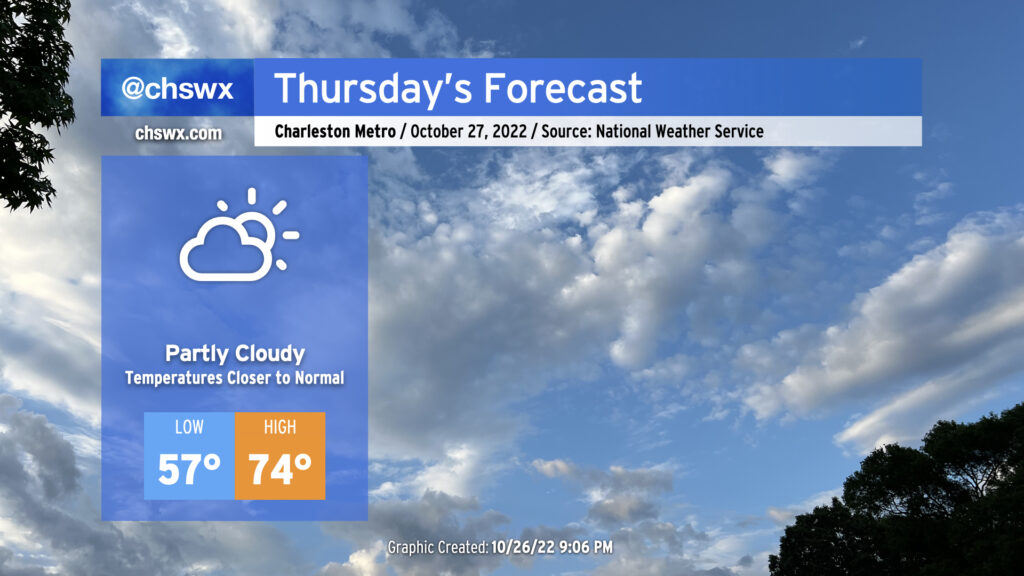
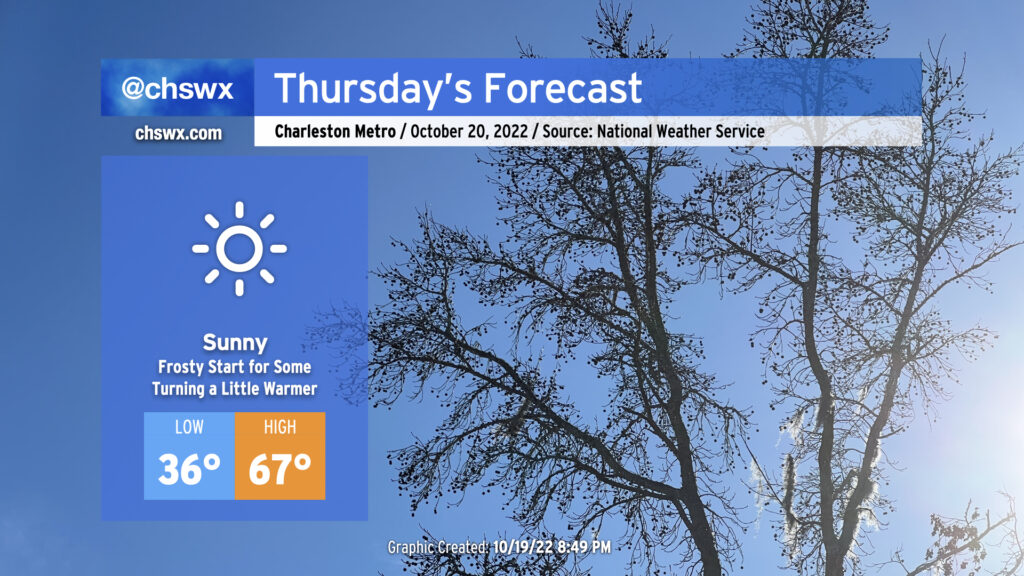
We’ve got more clouds and chilly weather in store for Thursday after a rather chilly and somewhat dreary day across the Lowcountry. The high temperatures of 68° at the airport and 70° downtown on Wednesday were set right around midnight as cooler air filtered into the area throughout the day. We should see another near-normal morning Thursday (lows mid-40s) before temperatures once again struggle into the mid-50s in the afternoon, well below the usually nice normal November temperature around 69°. There’s a decent chance we should see a little sun before the day is out, but overall, expect more in the way of gray. Silver lining: No precipitation is expected.
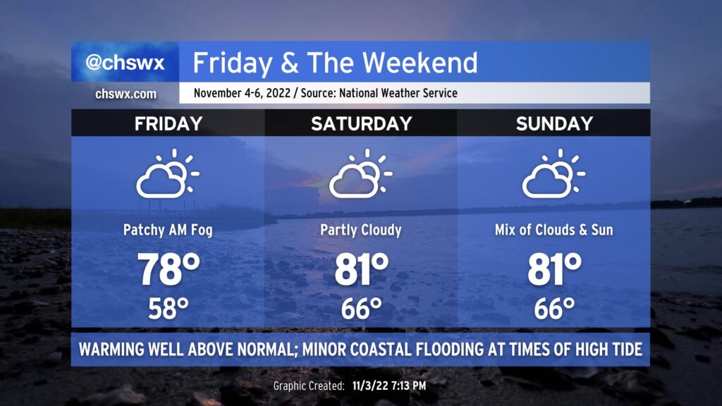
Even warmer weather is in the forecast for Friday and the weekend as high pressure at the surface slips offshore and winds turn southerly. Friday will still have a semblance of a fall feel, at least in the morning, as lows dip into the upper 50s ahead of highs in the upper 70s in the afternoon.
Thereafter, a more southerly component of wind begins to kick in, and we will begin to see temperatures (and humidity) kick up another notch. Saturday and Sunday will both start in the mid-60s — some 15° above normal — with highs reaching into the low 80s each afternoon. We’ll get close to record high minimums this weekend, but don’t anticipate breaching those. (The record high minimum for Saturday is 69°, and for Sunday is 71°, both set in 2003 during a record warm stretch.) Rainfall should be largely a non-issue, though a shower or two can’t be ruled out from time to time especially later this weekend as some upper energy interacts with a surface trough to our west.
The upcoming full moon and continued onshore flow will contribute to minor coastal flooding around times of high tide beginning Friday evening. More substantial coastal flooding will be possible as we head into next week as we watch for the potential for low pressure to develop in the western Atlantic, cranking the pressure gradient and northeasterly winds. This low could drive rain chances up in our neck of the woods as well, but the forecast extent of the rain still needs some finesse. Stay tuned this weekend for updates.
If you’re looking for a return to that fall feel that we had for a couple weeks in October, you may be waiting a little while: above-normal temperatures are favored through mid-month in the eastern third of the continental US. There are some signs that the pattern might change as we head toward Thanksgiving and beyond — stay tuned, though.
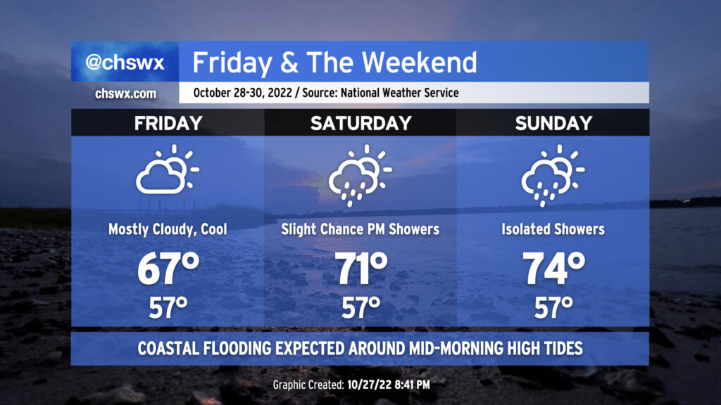
High pressure wedging into the area will keep clouds and cool temperatures around for Friday into the weekend. Temperatures shouldn’t get out of the 60s on Friday with a steady northeasterly breeze and mostly cloudy skies thanks to a thin layer of moisture being lifted atop the wedge. We could see a couple more breaks in the clouds on Saturday — along with a shower or two — as highs should creep above 70°. (Beware the wedge and its uncanny ability to bust temperature forecasts, though.) A warm front will sharpen and lift through the area on Sunday ahead of a cold front on Monday; this will help highs recover to the mid-70s in the afternoon. Moisture remains very shallow, but a shower or two can’t be totally ruled out in the evening hours.
The main weather hazard will continue to be coastal flooding thanks to continued astronomical influences from the lunar perigee and northeasterly winds. Friday morning’s high tide is expected to peak between 7.6-7.8′ in the harbor around 10:37am, which will be high enough to cause scattered road closures in downtown Charleston, particularly around the edges of the peninsula, a few hours on either side of that tide. Similar conditions are expected with Saturday morning’s high tide, forecast to peak a little after 11:30am. Water levels are expected to run a touch lower with the midday Sunday high tide, but should still be plenty high enough to produce minor to moderate coastal flooding, once again likely closing some roads. The good news is that any rain that falls won’t be very heavy at all, and won’t be enough to exacerbate any ongoing flooding.
A cold front is on its way through this evening, which will bring cooler temperatures for Thursday and beyond after highs peaked in the low 80s this afternoon away from the locally cooler coastline. Winds will go to the north and then the northeast overnight as high pressure builds in from the north and west. We’ll generally see scattered clouds throughout the day with those northeast winds keeping us about 5-7° cooler than we saw Wednesday. The aforementioned northeasterly winds and upcoming lunar perigee will contribute to another risk for minor to moderate coastal flooding around the 9:47am high tide, so be aware of the potential for closed roads once again tomorrow morning (though the peak of any tidal flooding should miss the bulk of any commute time at this point).
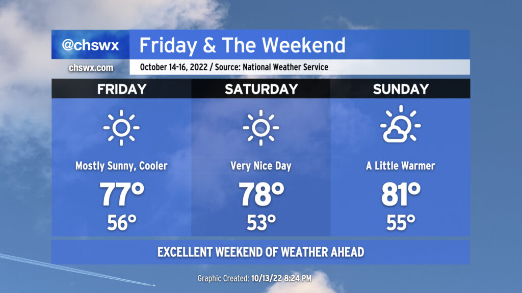
We’re back to the 70s starting Friday as the chilly airmass that’s brought us a couple mornings in the 30s continues to moderate. You’ll still want a hoodie in the morning as lows bottom out in the mid-40s, but it won’t be quite as cold as the past two mornings. The forecast high of 70° is still several degrees below climatology for this point in October, though.
We turn even warmer for the weekend. Lows in the 50s are anticipated for Saturday & Sunday, with highs in the mid-70s expected both days with just a few clouds from time to time. It’ll be another great weekend to get out and about.
You’ll be hard-pressed to find much in the way of rain for the foreseeable future; the extended NWS forecast remains quite dry, with a small chance of a shower or two mid-week as a weak front passes by. Temperatures will climb to slightly above normal for early next week before the front cools things off slightly.
Some of us are going to get off to a frosty start on Thursday as temperatures fall into the mid-30s overnight, perhaps threatening the record low of 34° set in 1981. A Frost Advisory will be in effect from 4-9am for inland Berkeley and Dorchester counties as this is where temperatures are most likely going to be low enough to support frost formation. I don’t know that I could totally rule some patchy frost out a little further eastward as well in more sheltered spots. Bring in plants and pets tonight to be safe.
From there, full sunshine will begin to modify the chilly airmass that’s been in place over the past couple days. Highs Thursday afternoon will still run well below climatology for this point in October, but will be a few degrees warmer than we felt Wednesday, topping out in the mid-to-upper 60s. (More on Wednesday’s temperatures in a sec.)
No weather worries as we head into Friday and the weekend as comfortable temperatures take hold behind a cold front coming through overnight.
Friday looks outstanding. Lows in the mid-50s will rebound to the mid-to-upper 70s under full sunshine. Dewpoints below 50° (away from the coast, anyway) will keep things quite comfortable. Winds behind the front will be generally light, generally around 5 MPH from the north. Friday could be one of those rare Severely Nice Weather Alert Days around here, that’s for sure.
Saturday could also qualify as a Severely Nice Weather Alert Day. We’ll start a little cooler — low 50s will be common away from the warmer coastline — and head into the upper 70s under continued uninterrupted sunshine. Winds will be quite light, generally out of the east.
We begin to turn a touch warmer on Sunday as winds go southwesterly ahead of our next front. (More on that in a minute.) Temperatures will run in the low 80s with a few clouds in the afternoon. Sunday’s weather remains excellent, though, and will be a little more palatable to those who like it a little warmer. Something for everyone this weekend!