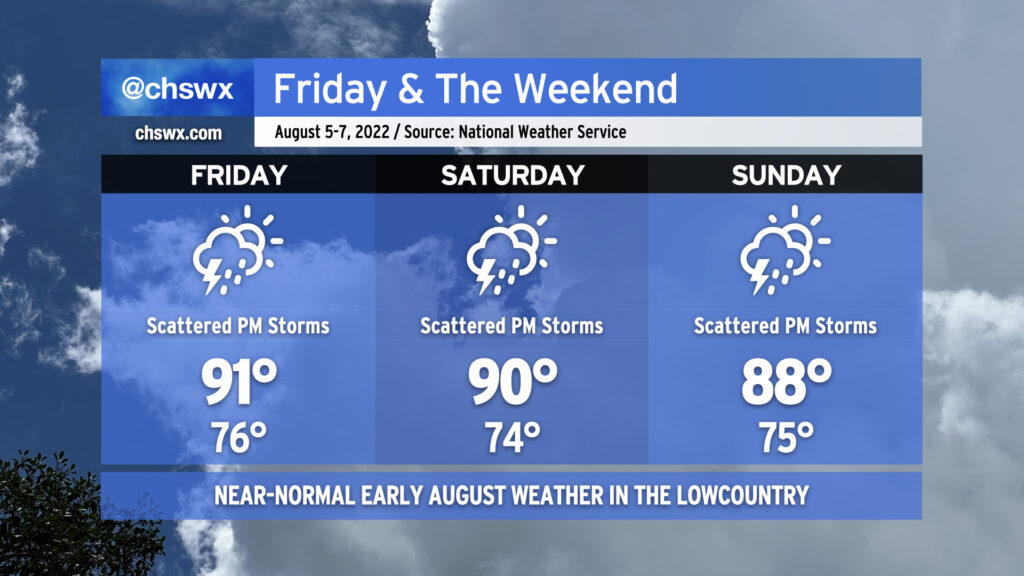
Atlantic high pressure keeps us appropriately warm and muggy by early August standards for tomorrow into the weekend. Onshore flow will help air temperatures run in the upper 80s to low 90s each afternoon, while humidity will make it feel closer to the upper 90s and low 100s.
The aforementioned onshore flow keeps a chance of showers in the forecast Friday morning closer to the coast. Rain chances will migrate inland with time, with a few thunderstorms possible as the seabreeze pushes inland across the area during the afternoon and early evening hours. Saturday’s setup looks similar, too, though the NAM nest is a little less excited about morning showers. Sunday could be a little more active as what looks like a weak TUTT (tropical upper-tropospheric trough) whirls into the area from the east, helping to enhance shower and storm coverage across the area. Overall, the risk for severe weather remains low, but as always, lightning makes every thunderstorm dangerous. When thunder roars, go indoors!
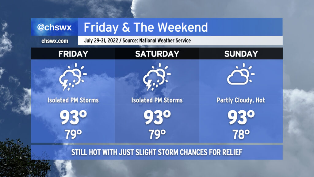
We’ll stay hot heading into the last few days of July as ridging continues to feature prominently in the weather pattern. Temperatures will run in the low to mid-90s each day, with heat indices between 105-108° a distinct possibility during the height of each afternoon. Lows, meanwhile, will struggle below 80° away from the coast, with temperatures not getting below 80° at the beaches for the foreseeable future. Isolated thunderstorms appear possible each afternoon — it’s hard to avoid this time of year, but the risk for additional rain remains quite low overall. Where storms develop, pockets of locally heavy rain and gusty winds will be possible, but as mentioned, they’ll be quite sparse — a relatively quiet end to what’s been a rather unsettled month.
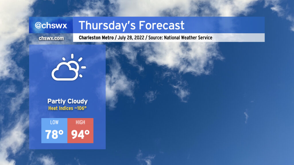
Another hot day is in store Thursday. After starting in the upper 70s away from the coast and Downtown (lower 80s there, gross), temperatures will warm to the mid-90s in the afternoon under partly cloudy skies. Mix in humidity and that’ll yield heat indices around 106°, plenty warm enough for heat exhaustion concerns during the peak of the afternoon. Much like today, expect rain-free conditions to persist as high pressure and the surface and aloft keep thunderstorm development at bay. Indeed, the only relief may be a cumulus cloud or two blocking out a bit of sun for a time.
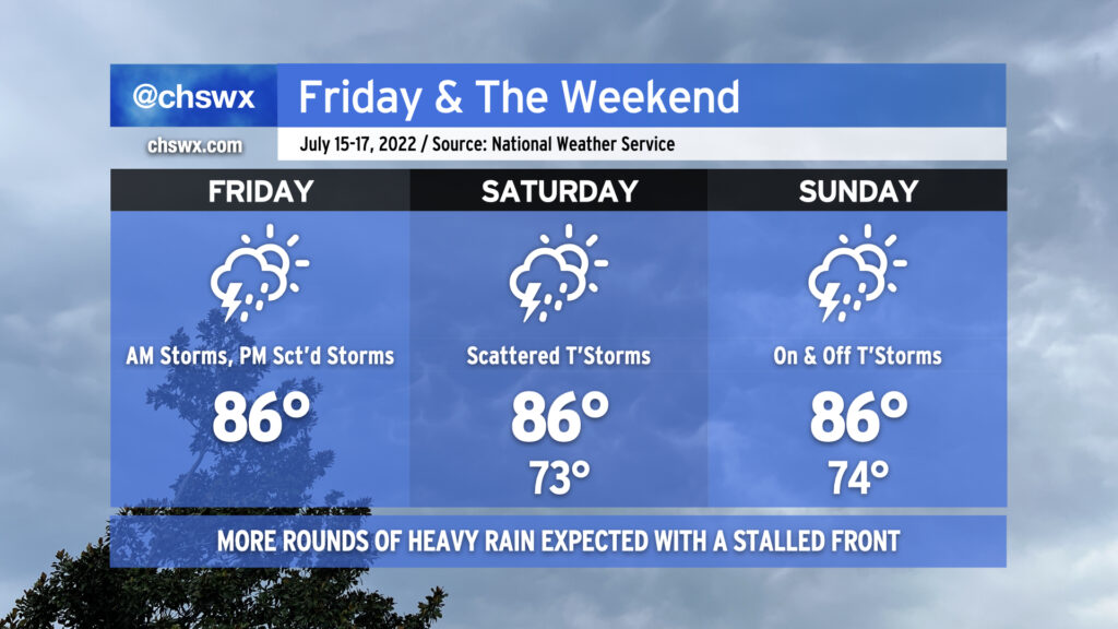
More steamy and occasionally stormy weather is in store for the weekend as a cold front moves close by and stalls out. It won’t be a total rainout, but backup plans for weekend activities are not a bad idea.
Friday should start out rain-free in the metro area, but it’ll still be quite warm as we start In the mid-to-upper 70s, warmer toward the coast. Temperatures should rise to around 90° by early afternoon before thunderstorms develop. Humidity will make it feel closer to 103°. Once again, there’s a risk for very heavy rain with these storms, and given the soaking we’ve had recently, flooding is once again a concern.
And so it will go heading into the weekend, as well, with the stalled front acting as a focal point for additional showers and thunderstorms to develop around the area. Temperatures will, before thunderstorms mess things up, top out around 90° each day, with heat indices reaching into the 100s. Heavy rain and flooding remain a threat; a wet microburst with damaging wind gusts can’t be ruled out in the strongest storms, either.
There is change coming, though. We’ll see high pressure begin to reassert itself both at the surface and aloft. This will help to suppress the more widespread thunderstorm activity we’ve seen for the balance of this month as we head into next week, though it won’t eliminate it completely as an isolated shower or storm will be possible along and ahead of the seabreeze. Temperatures, though, will continue to generally run in the low 90s each afternoon, with heat indices continuing to run in the low 100s. And so, summer rolls on. (At least the tropics remain quiet!)
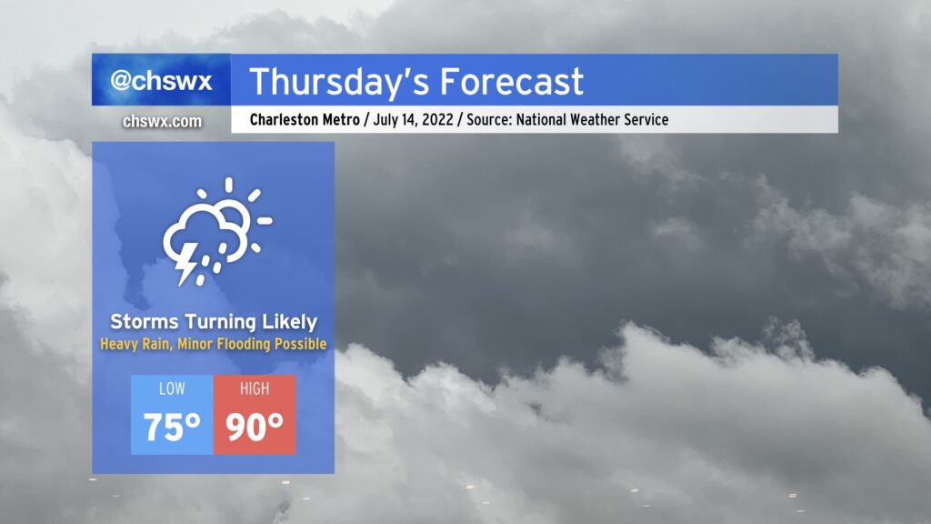
After an absolute deluge last night, with some weather stations in the Summerville, Ladson, and Hanahan areas reporting upwards of 5-8+” of rain and reports of numerous roads and even some properties seeing flooding, we will continue with the risk for showers and thunderstorms for today into the weekend. Temperatures will be held into the mid-80s given cloud cover and nearby thunderstorm activity, which will be possible pretty much at any point throughout the day but particularly in the afternoon hours. It’s worth noting that it won’t rain all the time, either. We’ll undoubtedly see some peeks of sunshine intertwined in. When it does rain, though, it could be quite heavy, which isn’t good news considering how waterlogged many of us have become in this wet pattern over the past couple weeks. (In fact, the drought has been eliminated in the Charleston metro area.) The main weather hazard to watch will be flooding, but there will also be a low-end risk each day for an isolated wet microburst producing damaging wind gusts. Stay tuned to forecast updates throughout the weekend as the specific details of where it will rain exactly when are difficult to fully pin down until a few hours out.
Another front will be approaching the area on Thursday, and this will bring a renewed round of heavy showers and thunderstorms in the afternoon and evening hours, one or two of which could be on the strong to severe side with damaging wind gusts. The main concern, though, will be the potential for very heavy rain. We’ve gotten pretty waterlogged in the past few weeks, and continued heavy rain on top of it will lend itself to the risk of some flooding.
It will be another sauna day, with highs topping out around 90° and heat indices rising into the low 100s thanks to the continued stifling humidity that’s blanketed our neck of the woods for the better part of July. The heat and humidity should help fuel-wise for showers and thunderstorms in the afternoon.
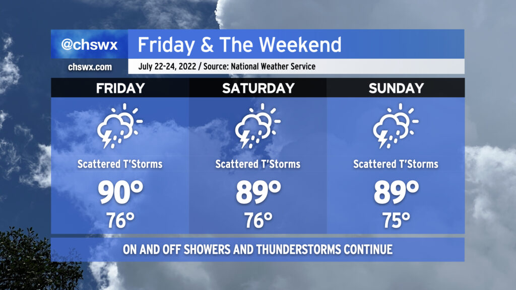
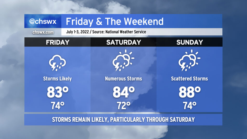
As ridging aloft breaks down and retrogrades westward, our weather will turn much more unsettled heading into Friday and the weekend. Storms will be likely especially each afternoon and evening, with Sunday possibly looking particularly stormy with a surface front pushing through the area. Heavy rain will once again be quite possible, as precipitable water values remain 2″+ throughout the period — a lot of water to wring out of the atmospheric column, to be sure. Excessive rainfall will be possible in the strongest storms. There will also continue to be a risk for sporadic severe weather in the form of damaging straight-line wind gusts.
Temperatures on Friday and Saturday will still head right into the upper 80s to low 90s. With a stiflingly humid airmass continuing in place, heat indices will once again soar well into the 100s, with max heat indices around 105° on Friday and 108° on Saturday. Showers and thunderstorms will keep air temperatures from getting too much further out of hand, thankfully, but this is plenty of heat as is. Remember to take frequent breaks in the shade if you’re outside during these hot periods.
The good news is that all this rain continues to erode the drought — much of the Tri-County area was in moderate drought on last week’s Drought Monitor, but today’s downgrades the area (particularly around the Charleston metro) to Abnormally Dry. The airport is still running about 4.62″ behind normal for this point in the year, but we should hopefully continue to dent that deficit this weekend.
After some of us got a day to dry out, showers and thunderstorms look to resume possibly as early as late tonight as a disturbance aloft possibly spawns a little surface low in southeast Georgia. This possible low, if not the associated surface trough, will help to keep numerous showers and thunderstorms in the forecast for Friday and into Saturday as well. We could see storms ongoing Friday morning for the commute, so be ready to take it a little slower on the roads. Heavy rain and lightning will be the primary issues from any thunderstorms. The atmosphere remains juiced with plenty of moisture: precipitable water values (the amount of water you can wring out from a column of air) will continue to run very close to 2″. This moisture combined with ample instability will likely lead to some pockets of very heavy rain rates and a risk of minor flooding to go along with it. Also, it’s worth noting that high tide will peak around 10:17 AM in Charleston Harbor. Guidance does show some heavy downpours coming ashore ahead of and around this time, which could enhance the flood threat in coastal communities including downtown Charleston. With the prevalent storms and cloud cover, highs should top out in the mid-80s at best. It’ll be quite humid, though, and so heat indices could run up toward 90° especially if some sun peeks out.
Saturday looks like it could get off to a similar start as broad surface low pressure may be moving through the area during the morning. Additional showers and thunderstorms could then fire in the afternoon in the wake of the low depending on how well the seabreeze ultimately develops. Temperatures should stay capped in the mid-80s once again, owing to the unsettled weather that’s expected. Something tells me the details around Saturday will be refined some more, too, so stay tuned.
Sunday will be a little more summer-like in nature with more widely scattered thunderstorms, particularly in the afternoon. Temperatures will rebound from previous days into the mid-to-upper 80s.
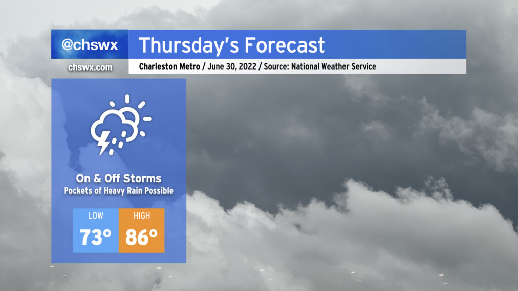
After record rainfall today — 1.87″ of rain at the airport breaks the record of 1.54″ set in 2000, while stations in West Ashley picked up 2.5-3″ — more storms are on the horizon for the next few days as we remain within a very humid airmass with plenty of upper-air and surface features to help spur on shower and thunderstorm development.
Thursday looks to go similarly to the past couple days, though there may not be quite as much coverage as we’ve seen thus far this week. We could see showers and storms forming early in the day near the coast, with storms becoming scattered to numerous while translating inland with the seabreeze throughout the afternoon. With precipitable water values near 2″, we once again could see pockets of very heavy rainfall. The past couple days have seen a couple 4″ bullseyes, and I can imagine that will be the case somewhere again tomorrow. The severe weather risk remains very low given the very saturated atmosphere, but lightning and isolated bouts of excessive rainfall will make any thunderstorm dangerous. High temperatures will remain suppressed in the mid-80s, though the humidity will still be rather swampy.
A front will sag southward across the area on Friday, bringing with it some cooler temperatures and a slight chance of afternoon thunderstorms. We’ll lop about 6-8° off today’s observed high of 96° tomorrow as winds turn a little more onshore as the front gets by. Only a few of us will see storms tomorrow, so keep the watering gear on standby as you’ll probably need it for a few more days.
Ridging aloft will continue to build into the area for the weekend, but east to northeast winds at the surface will help keep temperatures and humidity (to an extent) in check. Expect highs in the upper 80s to around 90° each afternoon with dewpoints running in the upper 60s, yielding heat indices in the low 90s. Mostly sunny skies will be the rule with the somewhat drier atmosphere and sinking air keeping updrafts in check. While the air won’t feel quite as nice as last weekend, it’ll still be a good couple beach days. Pack the sunscreen!