Atlantic high pressure and ridging aloft remains in control of our weather for a few more days before a pattern change greets us with increased chances for showers and thunderstorms for the new work week.
Temperatures through the weekend will top out in the low 90s each afternoon, but low-to-mid-70s surface dewpoints will make it feel a little closer to 100°. We’ll see the standard mid-July isolated to scattered coverage of showers and thunderstorms ahead of the inland-advancing seabreeze each afternoon. You can never totally rule out a strong wind gust or two to cause problems with any summertime thunderstorm, but the risk for severe weather looks quite low. This setup should yield a few good, if not hot, beach days — pretty much exactly what we should expect this time of year.
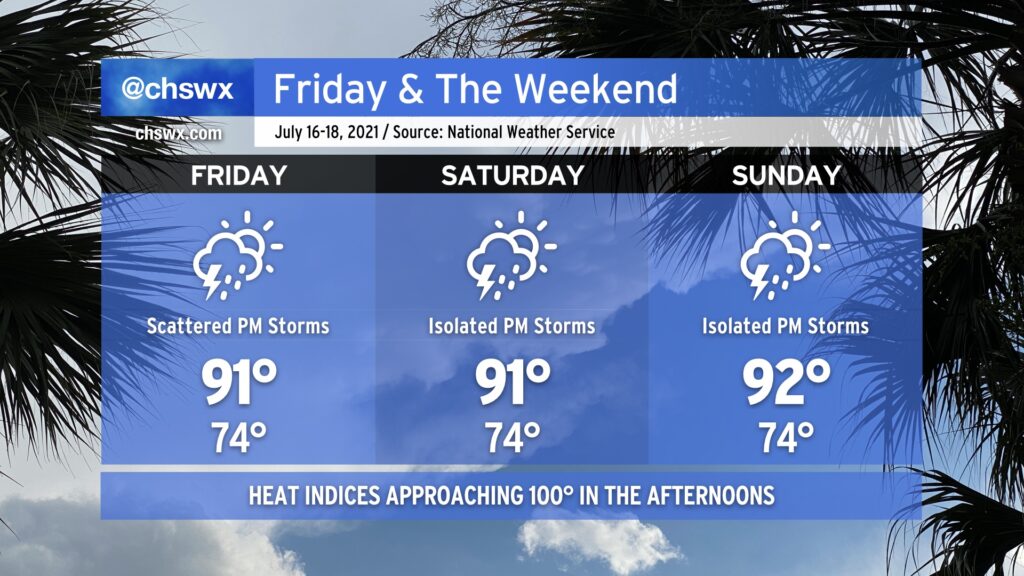
A little more normal July weather greets us for Friday and the weekend. Temperatures will run in the low 90s each day; humidity will push heat indices into the low 100s. We’ll see isolated to scattered showers and storms each afternoon as daytime heating and a little residual upper energy combine to fire off convection across the area. Isolated areas of heavy rain will be possible. Severe weather looks unlikely, but a couple wet microbursts can’t be ruled out where outflow boundaries collide. (At least it’s not a tropical storm.)
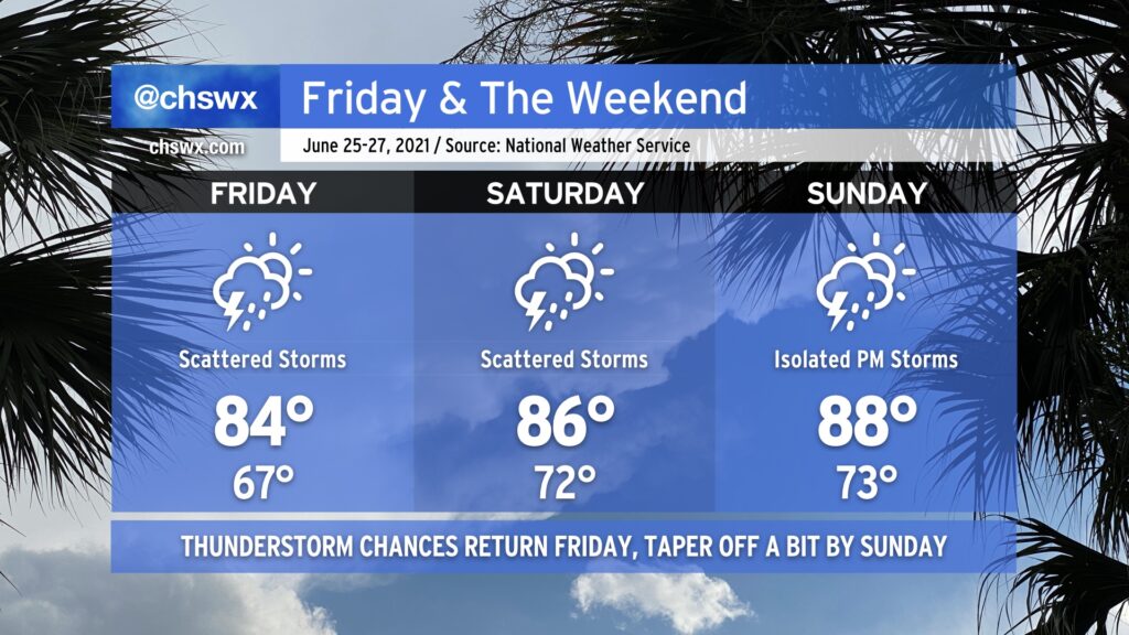
After a remarkably nice couple days behind a rare summertime cold front, said front retreats back over our neck of the woods as a trough of low pressure on Friday, bringing humidity, showers, and thunderstorms back into the weather picture. These elevated rain chances stick around to start the weekend before tapering off to more traditional isolated afternoon thunderstorm coverage on Sunday. Temperatures warm up from 84° on Friday to 88° on Sunday, but we are typically talking about 90s on a regular basis in late June, so we’ll take it.
One thing I’m not seeing is a total washout of the weekend by any stretch. Don’t cancel outdoor plans, just have a good backup ready to go in case you need it. Remember, all thunderstorms are dangerous because of the lightning they produce. If you see lightning or hear thunder, you’re close enough to be struck, so get inside as soon as you can if storms approach.
Coastal flooding will remain a possibility Friday and maybe Saturday nights as lingering astronomical influences and continued onshore flow could push tides above 7’ in the harbor in the late evenings. Be ready for additional bouts of coastal flooding and possible road closures as a result.
After what ended up being a stellar Thursday for mid-June, we’ll get another warm but less humid day for Friday. Temperatures will start in the upper 60s and will top out around 90° in the afternoon. Dewpoints will run in the upper 60s to around 70°, yielding heat indices a couple ticks above the air temperature, but nothing we can’t handle.
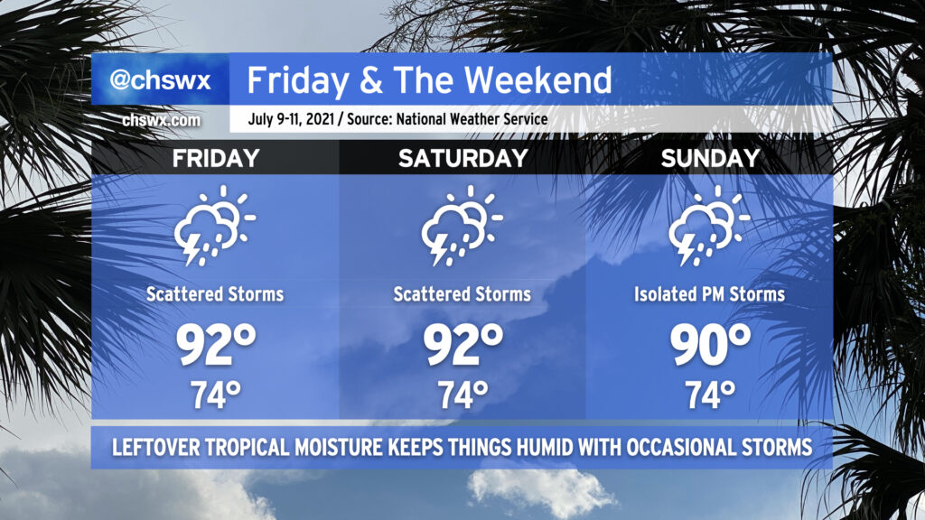
As we get into the weekend, we will start to see tropical moisture increase across the area ahead of what is currently Potential Tropical Cyclone 3. There are some timing differences in the models which will have influences on the forecast, but for now, Saturday could feature a couple showers and storms in the afternoon and evening hours after a high of 91° that will feel closer to 97-98°. As we get into Sunday, moisture continues to increase, and the remnants of the tropical low move roughly along the NC-SC border. This will continue to kick up showers and storms into Sunday. Expect periods of heavy rain at times. The big question, though, remains timing, which has run a little later in recent guidance. Thus, I wouldn’t start canceling too many plans just yet — just keep an eye on forecast updates as we get into the weekend.
We have another hot day in store for Friday as temperatures once again head back into the low 90s in the afternoon. Humidity will make it feel closer to 100° once again, especially in the early afternoon. Like today, we can expect a few scattered showers and thunderstorms in the afternoon. Not everyone will get rain, but those who do could see a brief downpour along with some lightning.
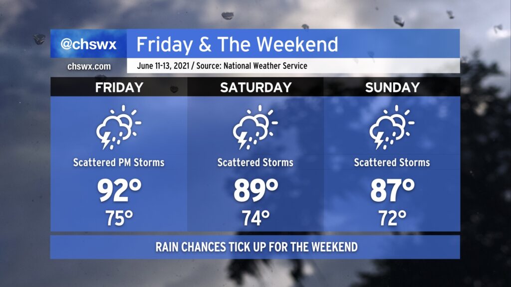
As we get into the weekend, we will see a front start dropping into the area from the north as a trough digs in aloft. This will contribute to additional coverage of showers and thunderstorms during the day Saturday. Plenty of moisture in the atmosphere will allow for heavy rainfall to develop, and given that slow storm motions are expected, some minor areas of flooding are certainly possible. Look for highs near 90° before storms kick in.
The front will continue to sink south of the area as we get into Sunday. Alas, this isn’t the kind of front that gets us much in the way of a cooldown, and indeed, the front will dissipate as it continues to push southward. Still, expect scattered storms to continue to be a factor on and off during the day. High temperatures will once again run in the upper 80s before showers and storms begin to develop.
This unsettled pattern looks to continue into next week as a trough of low pressure persists in the east. Good news here is that there will be more chances for beneficial rain across the Lowcountry in that time, but let’s hope we don’t get too much of a good thing all at once, either.
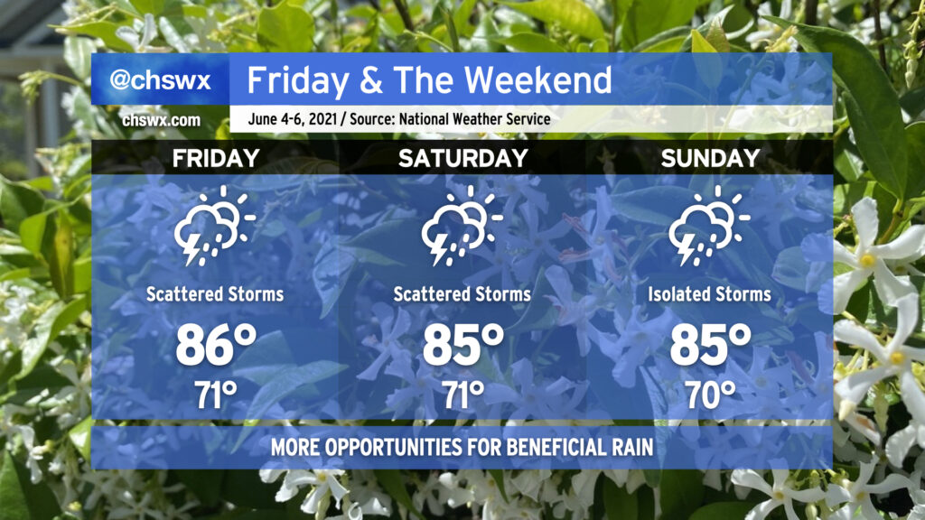
Scattered showers and thunderstorms will continue to factor in prominently in the forecast over the next few days, with periods of heavy rain possible especially Friday and Saturday. A storm or two may be able to produce a wet microburst, but other than that, no severe weather is expected. Storm motions will be watched closely for any training of heavy rain, and we’ll also keep an eye on tides in case radar trends show heavy rain approaching downtown. We’ll begin to see a downtick in storm coverage as we get into Sunday, when high pressure nudges back in a little bit, but we’ll still see more typical-for-June afternoon shower and storm chances along the seabreeze. It won’t rain all day, and it won’t rain all the time — just ensure you have a backup plan for your outdoor activities if and when it does rain.
The one benefit to these storms is that it’ll help keep temperatures down to around normal values for early June, with highs in the mid-80s. Even still, dewpoints around 70-72° will keep these highs feeling closer to the low to mid-90s, but at least it won’t be hotter with the same humidity.
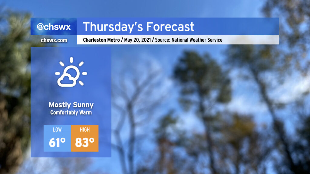
Thursday is looking quite good with high pressure beginning to assert greater control over our weather. The periods of showers we saw over the past couple days will be a thing of the past, and temperatures will remain comfortably warm with onshore flow. After starting the morning in the 60s, expect highs in the low 80s away from the immediate coast. Dewpoints in the upper 50s keep heat indices in check, making for a nice mid-May day.
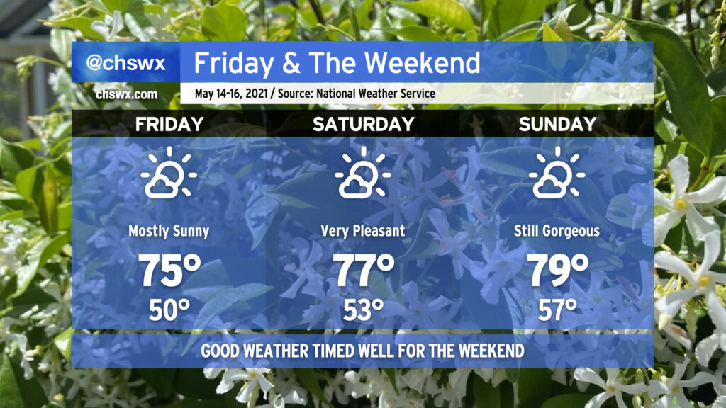
After a nicer-than-expected Thursday, we have a pretty outstanding mid-May weekend coming up in the Lowcountry. High pressure will remain the dominant player in our weather both at the surface and aloft. Onshore winds will keep temperatures quite comfortable, and deep-layered dry air will help mix dewpoints out into the 40s during daytime heating, providing for a comfortably dry atmosphere particularly on Friday and Saturday. The airmass will continue to moderate through the weekend, and we should be back to around 80° by Sunday. Overall, this is a great opportunity to get out and about — summer and its associated muggy heat will be here before you know it.
No complaints about this weekend’s weather: Solid late-spring fare for the Lowcountry, with low humidity, a chill in the air to start each morning, and comfortably warm temperatures each afternoon under plenty of sunshine with just some fair weather cumulus at times providing a little natural shade. (Mom will love it.)
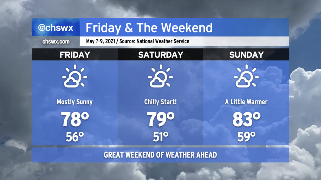
If I had to pick a day out of the three for the best weather, I’d say Saturday is probably it for its wide spectrum of temperatures, low humidity, and relatively calm winds. Friday and Sunday look to be a bit on the breezy side with high pressure building on Friday and beginning to depart on Sunday.
We’ll need to monitor weather conditions for enhanced fire danger over the next few days as we still remain abnormally dry. A Fire Weather Watch is in effect for Friday due to very low humidity and winds gusting up to 30 MPH at times, and I wouldn’t be surprised to see fire danger remain elevated into Sunday before our next rain chances arrive Monday. Please don’t burn outdoors as flames could quickly get out of hand. Otherwise, though, enjoy a nice weekend!
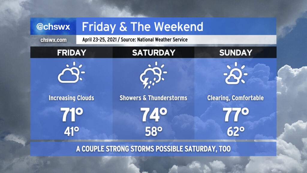
Friday will start out as another chilly morning as temperatures will dip into the low 40s. Frost should not be a concern in our neck of the woods, though, so no worries for your gardens. Temperatures will top out around 70-71° with cloud cover on the increase ahead of our next storm system. Note that fire danger remains high on Friday given continued dry conditions and low humidity.
Saturday will bring beneficial rain to the area, but it may bring some stronger thunderstorms as well. Showers will be possible on Saturday morning, but the best chance for heavier rain and thunderstorms arrives in the afternoon into the evening hours. NWS estimates rainfall amounts around 1-2″, which would be hugely helpful as long as we don’t get it all at one time. Temperatures look to top out in the mid-70s barring more rainfall earlier in the day. Regardless of thunderstorms, winds should be fairly breezy with gusts perhaps near 35-40 MPH at times.
The severe weather threat for Saturday will largely be modulated by how unstable the atmosphere can get. Wind shear will be plentiful thanks to a strengthening low-level jet and favorable upper-level winds, so that ingredient will certainly be there, and there is general model agreement that moisture will surge into the area later Saturday, which may contribute to further destabilization. A lot will depend on how warm we can get during the day — if rain fires up and sticks around, which is certainly possible, then that takes the severe threat down a peg or two (but doesn’t completely eliminate it given the aforementioned favorable wind shear). If it doesn’t, though, there will be fuel available for the storms by the time they get here, and with the expected shear in place, a few severe storms will be expected. Damaging winds and hail will be the primary concerns, but given the favorable vertical wind profiles, a tornado cannot be ruled out.
All this nastiness clears the area overnight Saturday as a front sweeps through, and by Sunday, we will have a much nicer day with clouds gradually breaking down and temperatures rising into the mid-to-upper 70s. It’ll remain windy throughout the day in the wake of the front as high pressure builds in behind it, but otherwise, there are no weather concerns for Sunday into much of next week as our fairly arid April rolls on.