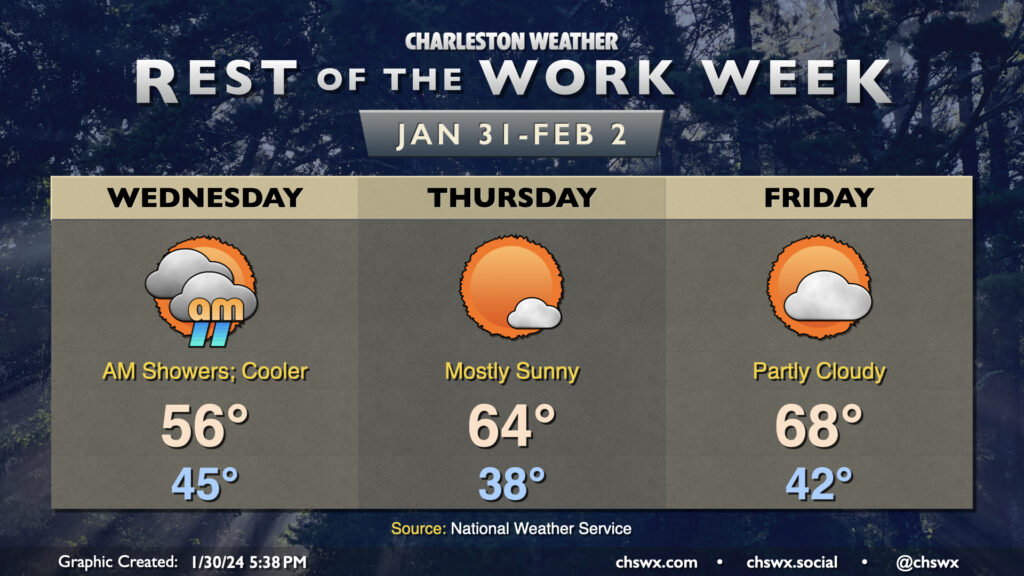
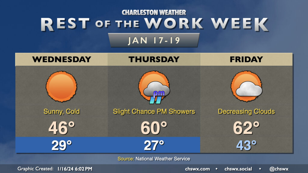
Generally quiet weather continues for the balance of the work week. The exception will be Wednesday morning, when a little bit of energy aloft traverses the area and squeezes out some shower activity. Rain gauges won’t catch much precipitation at all, and it should be out of here by afternoon. Clouds could hang around, though, and some cooler air blowing in behind the disturbance will keep highs pinned to the mid-50s Wednesday afternoon.
High pressure — and, as a result, sunshine — returns to close out the work week. Expect mostly sunny skies on Thursday. After a seasonably cool start in the upper 30s, highs will warm to the mid-60s in the afternoon. Friday is still looking good, too, with low 40s yielding to upper 60s in the afternoon under partly cloudy skies, so if we get stuck in a temporal loop, at least the weather will be nice.
Peeking ahead at the weekend, we see a quiet and seasonably warm Saturday but an increasingly unsettled Sunday as another storm system approaches the area. This storm system peaks overnight Sunday into Monday with decent rainfall expected. Rain chances diminish heading into next Tuesday, with a little bit of a chill in the air as well.
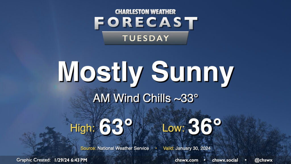
Expect another seasonally-appropriate day on Tuesday, though we will start out a little cooler than we did on Monday. Lows should bottom out in the mid-30s, and with a little wind still blowing, it’ll feel a few degrees cooler. Temperatures should head to the low-to-mid-60s under mostly sunny skies. Winds will shift southerly and pick up a bit in the afternoon ahead of a weak low, nudging dewpoints up a few degrees but certainly nothing outrageous.
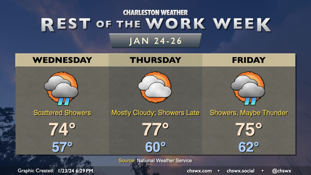
The warming trend continues Wednesday as a warm front lifts north of the area. Temperatures start in the mid-to-upper 50s owing to cloud cover blanketing us for much of the night. Once the warm front shifts ashore and winds go southeasterly, temperatures will respond further and head to the mid-70s. It’ll be kind of muggy, too, with dewpoints in the mid-60s expected behind the warm front. Scattered showers will remain possible throughout a fair bit of the day, though we should see more sun than we did Tuesday (not hard to do, tbh).
At a minimum, we’ll get the first part of Thursday in rain-free, if not the vast majority of it, before a front approaches the area and reintroduces shower and storm chances for Friday. Temperatures will peak Thursday, with lows in the low 60s and highs topping out around the mid-to-upper 70s. There will be a chance for a few showers late, but most of us should stay out of that until Friday, when shower coverage looks to increase with some thunder possible as well. Severe weather currently doesn’t appear to be a concern, though, as wind fields are largely unimpressive and instability appears meager. Temperatures on Friday will be tamped down a little by the shower activity, “only” reaching 75° after starting in the low 60s once again. We stay in the 70s on Saturday, but a second, stronger front will restore order to temperature chaos on Sunday, and by Monday, expect temperatures near normal with much more sunshine.
After a day in which we warmed up some 14° compared to Sunday with a high of 60° at the airport, the warming trend continues for Tuesday and beyond as surface high pressure continues to move offshore. Temperatures on Tuesday start in the low-to-mid-40s — roughly where we were for a high on Sunday — and warm into the mid-60s in the afternoon under mostly cloudy skies. A few showers will be possible at times, but any rain will be generally light. Still, y’all know how traffic can get even with the lightest of rain, so prepare accordingly.
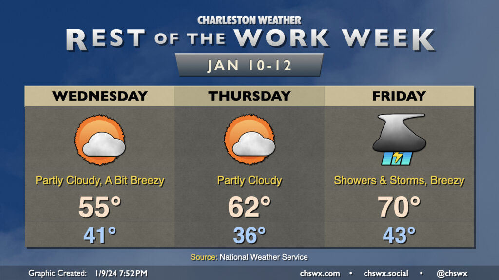
A rather cold day awaits on Wednesday despite full sunshine throughout the day as chilly high pressure builds into the area. Temperatures should fall to the upper 20s in the metro area early Wednesday morning as cold air blows in. Wind chills will bottom out in the low 20s, so be sure to dress accordingly as you head out to work or school. Afternoon highs will struggle to the mid-40s as cold air continues to settle into the area throughout the day. Despite light rain during the day Tuesday, black ice doesn’t look like it will be a factor given that we’ll be drying out very quickly tonight as dewpoints plummet into the 20s.
We’ll dip a little further into the 20s overnight Wednesday into Thursday morning. Temperatures should reach freezing by late evening, and should stay there through sunrise, with roughly an 8-10 hour period of freezing temperatures a decent possibility. It’ll be a good idea to keep a faucet on a drip, make sure pets are in a warm place, and ensure plants are protected. The good news is that the freeze will quickly give way to warmer temperatures Thursday afternoon, with highs expected to peak around 60°. A few showers will be possible in the late afternoon into the evening hours, but very little overall rainfall is expected.
Friday will be the only day in the next few that’ll start above freezing; expect lows in the low 40s in the morning, followed by highs in the low 60s in the afternoon. A cold front will advance through the area roughly midday or so, but the coldest air will be delayed a little bit. Still, expect clouds to scour out as drier air moves in.
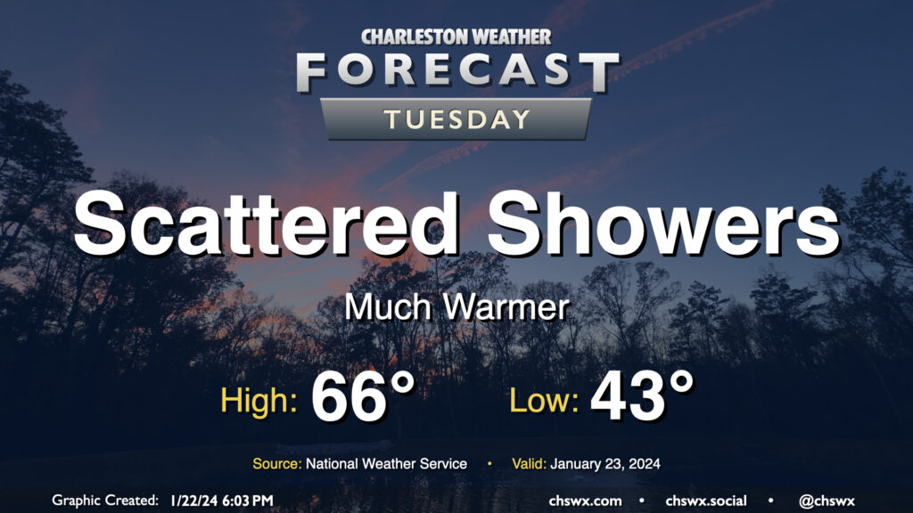
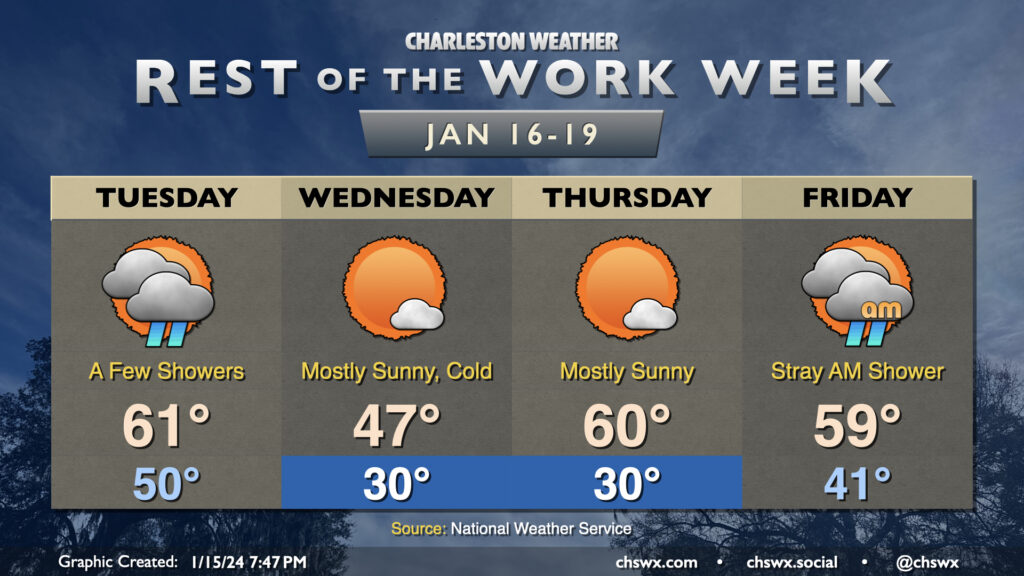
Temperatures will be somewhat fickle this week as a series of fronts move through the area. Tuesday will trend on the warm side, with lows around 50° to start the day heading into the low 60s in the afternoon as the first front moves by. A few showers will be possible along and ahead of the front, primarily midday through early evening. They won’t have much moisture to wring out, so expect the showers to be on the light side. From there, temperatures will plummet overnight.
We will most definitely know that a front has come through Wednesday morning. We’ll wake up to subfreezing temperatures across much of the area away from the immediate coast; breezy northwesterly winds will make it feel closer to the low 20s. The ongoing cold advection will prevent temperatures from reaching too far into the upper 40s in the afternoon despite mostly sunny skies.
Thursday gets off to a similarly chilly start (though with less wind, at least) as lows once again head toward around 30° (and likely colder further inland and in rural areas). However, the coldest air will be departing during the day, and temperatures head to around normal in the afternoon, generally running around 60°. The respite from the very cold air continues Friday. We’ll wake up in the low 40s and top out in the upper 50s to around 60° with a few morning showers possible as another front moves by, which brings the coldest air thus far this season into the area for the weekend.
After a day of weather that went more or less as advertised, we get a couple days to dry out before another round of showers and thunderstorms — and maybe some more severe weather — arrives on Friday.
We will stay breezy Wednesday, particularly in the morning, as cooler and drier air blows into the area behind a cold front. We start the day in the low 40s and warm to the mid-50s in the afternoon. A few clouds will be around, but overall it’ll be much sunnier than Tuesday. (Not hard to do!)
Thursday will feature calmer winds and a chillier start. We’ll begin the day in the mid-30s before warming to the low 60s in the afternoon under partly cloudy skies. It should be a fairly quiet, nice day of weather overall.
The quiet doesn’t last, though, as another storm system affects the area on Friday. While it won’t be as windy of a system as Tuesday’s was, it will still bring with it a fairly well-sheared environment which, if paired with enough instability, could yield another round of severe weather. The Storm Prediction Center has the area outlined in a 15% severe weather risk in the Day 4 outlook; we’ll see how this evolves as the rest of the week wears on. For now, though, don’t let the weather radio stray too far…we might need it again later this week.
Wednesday gets off to a freezing start across the metro area as lows dip into the low 30s away from the warmer coastline thanks to calm winds and mostly clear skies setting up for a good night of radiational cooling. The sub-freezing air doesn’t last long, though, as moisture increases ahead of a storm system that will be traversing the Gulf of Mexico during the day Wednesday. It’ll fling some showers our direction, primarily from late afternoon Wednesday into the overnight and very early Thursday morning.
The storm system clears the area by daybreak Thursday, setting up a couple quiet days of weather. Expect highs in the mid-50s on Thursday and Friday, with an upper 30s start on Thursday before heading back to near the freezing mark on Friday morning.
The holidays are over, and we’re back at it in 2024. The good news is that mostly quiet weather, except for a wet Wednesday evening, looks to be the rule for the first work week of 2024. A cold front coming by Monday evening (which was able to squeeze out a few showers as it passed) will set us up for a chilly start to Tuesday, with lows around freezing in the metro and likely below further inland. Despite clear skies, highs will only get to the mid-50s — a few degrees below early January normals (60°).
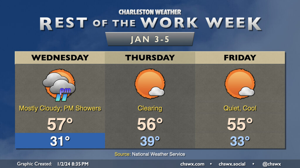
After a freeze in the morning, we’ll get much of Wednesday in rain-free before showers arrive generally around and after sunset ahead of another storm system. The rain from this will be reasonably short-lived, though, and should depart before daybreak on Thursday. We start Thursday around 40° and warm back into the mid-50s in the afternoon under partly cloudy to mostly sunny skies. Aside from a chillier start on Friday, in which we’ll once again flirt with freezing, expect highs to warm to the mid-50s once again under mostly sunny skies. The next storm system looks to arrive Saturday; it’ll probably be a bit more of an effective rainmaker than Wednesday evening’s storm, though it should depart by Sunday morning.
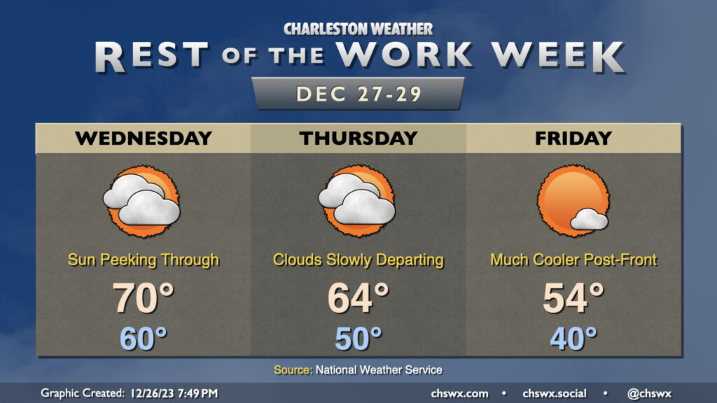
After low pressure departs the area early Wednesday morning, that will be it for rain for 2023 as we’ll embark on a drying and (slow) clearing trend heading into New Year’s Weekend. Wednesday will probably be the last day we touch 70° this year as cooler and drier air starts to work into the area later in the day. We’ll see dewpoints fall first and then temperatures will follow as we get into the evening hours. This’ll yield a Thursday that starts 10° cooler (but still well above late December normals) and warms to about the mid-60s in the afternoon. We should see a bit more in the way of sunshine on Thursday, but clouds will remain a bit pesky until a stronger (but dry) front gets through late Thursday. We’ll wake up another 10° cooler on Friday, with lows in the upper 30s to around 40° yielding to highs just in the mid-50s as cooler air works into the area throughout the day. At least the sun will be out!