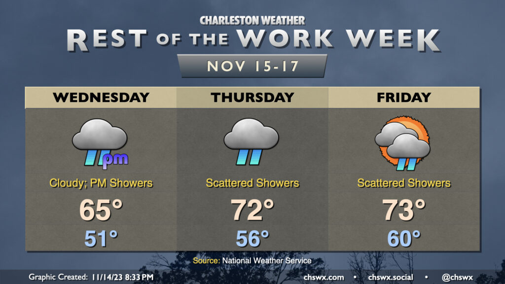
Showers re-enter the weather picture for the second half of the work week, though we’ll warm up a little in the process. Expect overcast on Wednesday before scattered showers commence in the afternoon. It doesn’t look like it’ll be a terribly heavy rain, but it could be enough to make the roads a little slick, so be careful when commuting. Temperatures start in the low 50s and rise to about the mid-60s in the afternoon as the cool wedge of high pressure hangs on for one more day.
The wedge starts to weaken Thursday, and despite overcast with periods of showers continuing, temperatures will run a little warmer. Expect mid-50s to start with low 70s in the afternoon. A few peeks of sun will be possible Friday, though scattered showers are expected to continue. Temperatures will run even warmer Friday, with lows around 60° and highs in the low-to-mid-70s.
Minor coastal flooding will continue to be possible with the morning high tides heading into the weekend. Water levels will generally peak around 7-7.1′ or so each day, which is enough to put some salt water on vulnerable roads in downtown Charleston. The highest tide capable of producing flooding on Wednesday is predicted around 8:47am, Thursday a little after 9:30am, and Friday around 10:30am. Stay tuned for Coastal Flood Advisories from the National Weather Service.
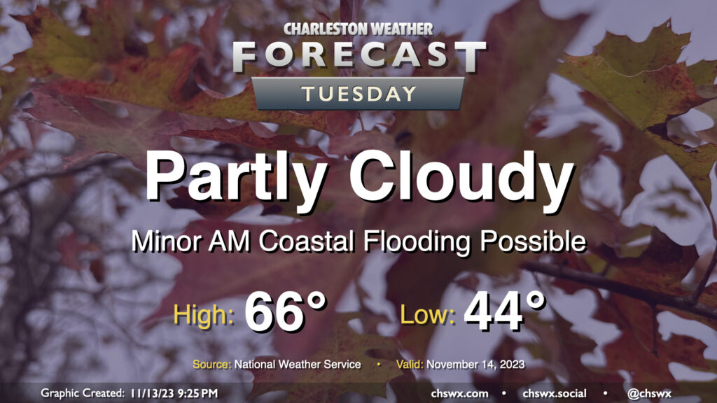
Another seasonably cool fall day awaits for Tuesday as we start to see an uptick in cloud cover portending more unsettled weather beginning later Wednesday into the rest of the work week. Temperatures start in the mid-40s before heading to the mid-60s in the afternoon, a couple clicks below normal but certainly very seasonally-appropriate. We’ll see ample sunshine, too, but as mentioned, cloud cover will begin to head up as we get into the evening.
High tide a little after 8am will be capable of producing some minor coastal flooding, with water levels generally approaching 7′ or so. It’ll be enough to put salt water on the most vulnerable roads — think around Hagood and Fishburne — but won’t cause widespread problems. Still, be ready to reroute around salt water-covered roads Tuesday morning.
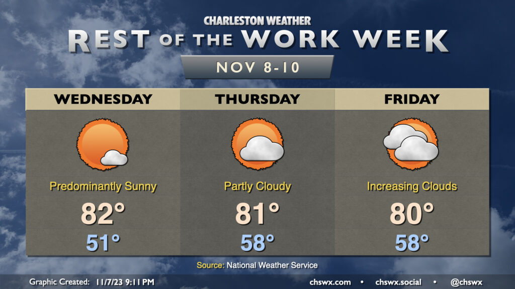
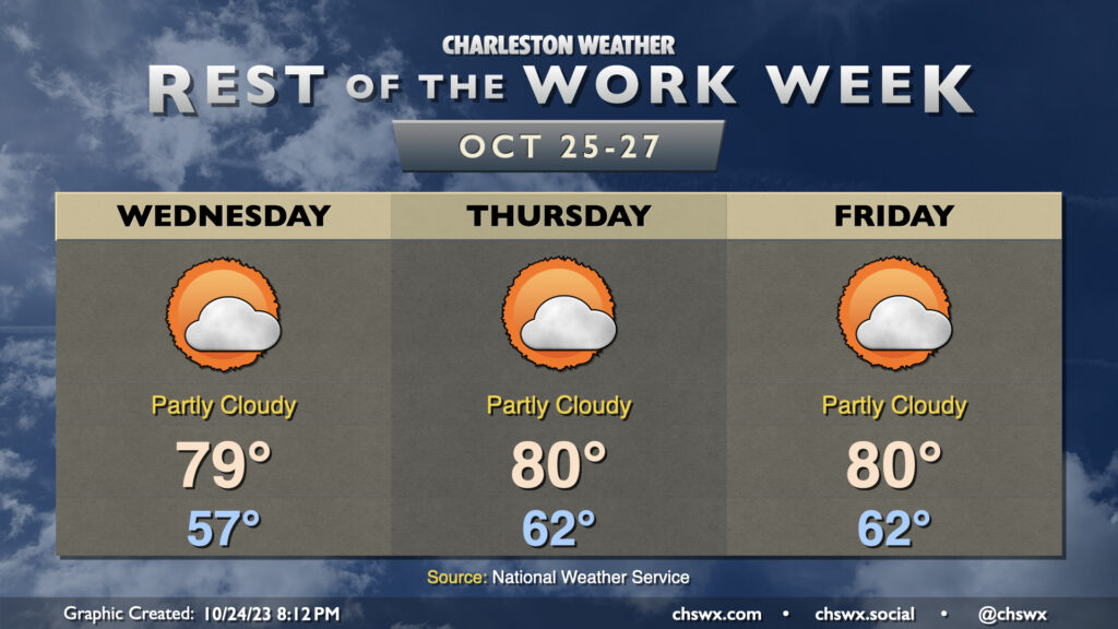
We have a few more days of above-normal warmth before changes in the form of a cold front and subsequent wedge of high pressure arrive for the weekend. For Wednesday, expect another predominantly sunny day starting around 50-51° before warming to the low 80s in the afternoon. Thursday gets off to an even warmer start as lows bottom out in the upper 50s. A few more clouds will dot the sky on Thursday, but we should still have no trouble reaching 80-81°.
Cloud cover continues to increase as we head into Friday, which will be the last of this long stretch of above-normal temperatures (for now, anyway). High temperatures will run in the low 80s for one more day as warm air pumps into the area ahead of a cold front. It increasingly appears we’ll stay rain-free Friday as the front looks to pass through Saturday morning, bringing with it a few showers and much cooler temperatures for the weekend into next week. It won’t be much in the way of rain, but any little bit helps as abnormally dry conditions continue to spread across the area.
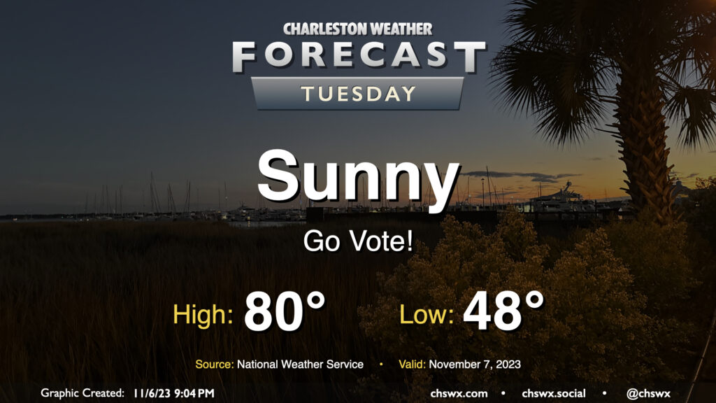
No concerns for Tuesday’s weather as we head to the polls for various local elections — not even any tidal flooding to speak of. We’ll start the day with a light jacket and shed it by midday as highs head to around 80° in the afternoon. Unfettered sunshine will be the rule with a light west to southwest breeze throughout the day.
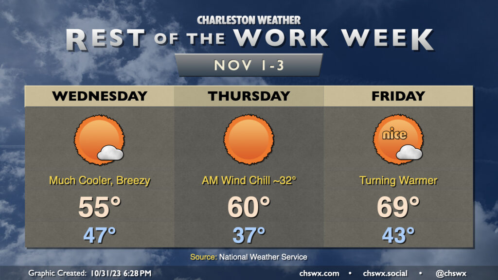
Legitimate sweater weather arrives Wednesday as the coldest air of the season thus far moves into the area. We start the day in the mid-40s but don’t expect temperatures to climb too much beyond the mid-50s despite lots of sunshine. In fact, we may at least tie a different kind of record high on Wednesday — the record low maximum temperature for November 1, which was also 55° last set in 2014.
Thursday looks to get off to the coldest start since early March, and a continued north to northeasterly breeze will drive the wind chill down to around or even below freezing. Dress accordingly in the morning! From there, highs will run a few degrees warmer than they did on Wednesday, but that’s not saying much as we’ll still see temperatures struggle to reach 60° despite unencumbered insolation. The record low maximum of 58° on Thursday is probably safe, but it’ll be close.
The airmass starts to moderate on Friday, though, as warmer air begins to work back into the area. We start Friday in the low 40s before warming to the upper 60s to around 70° in the afternoon under mostly sunny skies. The warming trend continues into the weekend, too, as we head back to the 70s each afternoon under partly cloudy to mostly sunny skies.
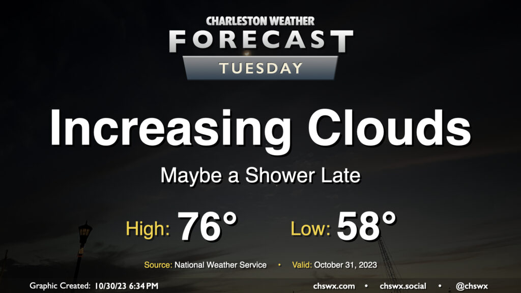
Changes are on the way on Halloween as a strong cold front moves across the area later in the day, bringing an uptick in cloud cover, maybe a shower or two, and a surge of the coldest air so far this season to start November. We start Tuesday in the upper 50s to around 60° with just a few clouds to start. From there, expect cloud cover to gradually thicken as the front gets closer. We should see it get through sometime mid-afternoon into the early evening; you’ll notice it when winds shift around more to the north.
Trick-or-treaters will want a light jacket as temperatures cool into the 50s throughout the evening. As mentioned, a shower or two will be possible, but the risk is quite low.
The rest of the work week will be seasonably warm as high pressure remains in firm control of our weather. We’ll start Wednesday noticeably warmer than Tuesday with lows in the upper 50s as opposed to the upper 40s. From there, temperatures will warm to near 80° under partly cloudy to mostly sunny skies. We start Thursday even warmer, with low 60s forecast — several degrees above normal for this point in the year. Temperatures top out around 80° with a mix of sun and clouds. As for Friday, copy and paste — pretty much the same story as Thursday. We keep warmth heading into the weekend and to start next week, though we should see a cooldown in time for Halloween.
High tides on Wednesday will get close to coastal flood criteria and could yet require a Coastal Flood Advisory or two if the departures tick up just a little more. We’ll flirt with minor coastal flood criteria at times of high tide into the weekend, so keep an ear out for possible Coastal Flood Advisories from the National Weather Service.
We get off to a fairly chilly start on Tuesday as lows bottom out in the upper 40s thanks to clear skies and light winds. This will be the low-water mark (so to speak) for temperatures, though, as we head into the rest of the week. Highs on Tuesday top out in the mid-70s once again, perhaps a degree or two warmer than we saw on Monday. All in all, another nice October day.
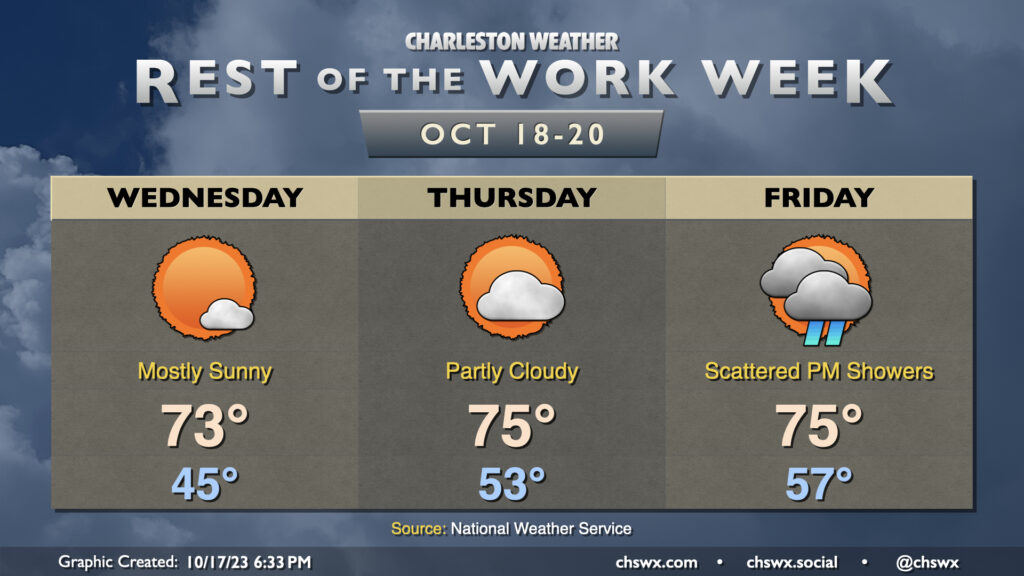
Sun continues for a couple more days before unsettled weather arrives later Friday with a cold front. Wednesday could be the chilliest start since April 18 if the NWS forecast verifies, with low to mid-40s common away from the locally warmer coastline. Temperatures will warm into the low 70s under mostly sunny skies, a couple clicks warmer than was observed on Tuesday.
Thursday runs even a little warmer as winds go a little more east to southeast, allowing some more moisture to work into the area. Expect to start Thursday in the low 50s before warming to the mid-70s under generally partly cloudy skies.
Our next rain chance arrives Friday afternoon into the evening ahead of a cold front. This will be the warmest overall day of the set as lows generally start in the mid-to-upper 50s before reaching highs in the mid-70s in the afternoon before showers begin. Right now, it doesn’t look like we’ll get much in the way of rain; generally around a quarter-inch at most. Of course, that doesn’t preclude a few spots from seeing some slightly heavier or lighter amounts.
Once the front is through, we have an excellent, seasonable weekend of weather on tap with lows in the low 50s and highs in the low 70s each afternoon with plenty of sunshine.
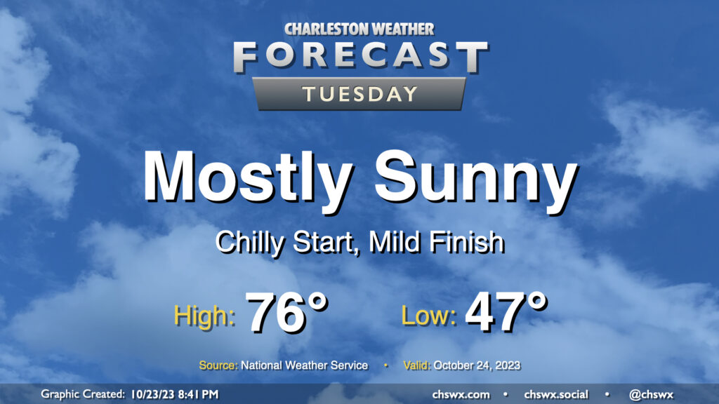
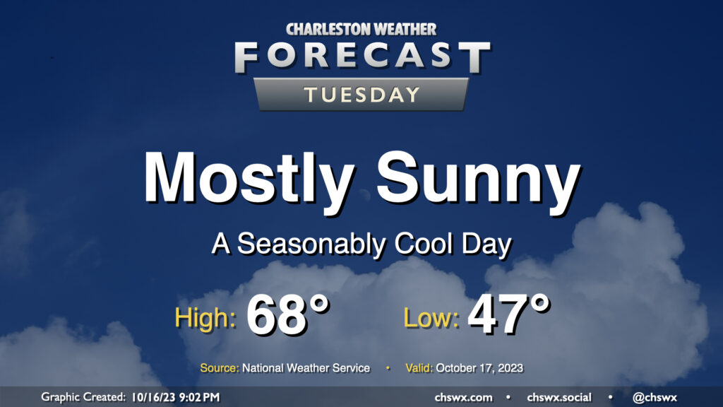
Tuesday will be another seasonably cool day under mostly sunny skies as high pressure remains in control at the surface with troughing aloft. After an upper-level disturbance passes by overnight Monday, skies will clear, allowing temperatures to fall into the upper 40s away from the coast for Tuesday morning. Temperatures then rise into the upper 60s, with the potential for a couple spots to hit 70°. Overall, a very seasonable October day across the Lowcountry.