Showers and thunderstorms remain in the forecast for Tuesday and beyond as a Rex block (high pressure to the north, low pressure to the south) sets up across the area, feeding in plenty of moisture and sufficient forcing to keep things quite unsettled. Expect the day to start out in the upper 60s to around 70° before warming to about the mid-80s before storms get going. There’s the potential we could even be dealing with some showers and storms advancing through the area in the morning if some of the high-resolution guidance is correct, too, but the best chance for showers and thunderstorms will arrive in the afternoon. Bottom line: Keep the rain gear handy throughout the day, and be patient getting to where you’re going.
After a brief reprieve Tuesday, storms look to return to the forecast on Wednesday as more upper-level energy moves across the area. We start the day in the low 70s before highs top out in the upper 80s in the afternoon under a mix of sun and clouds before showers and storms become more likely heading into the evening hours.
More showers and thunderstorms are in the forecast for Tuesday afternoon and evening as a stalled front hangs around the area. First, though, we’ll start the day in fine June fashion with lows around 70° in the morning. Temperatures should head to about 90° in the afternoon before thunderstorms fire. Dewpoints in the mid-60s should yield heat indices around 92° — nothing totally out of hand for this point in the year, but certainly steamy.
The summertime feel continues into Wednesday, as temperatures look to top out in the low 90s in the afternoon before thunderstorms develop once again in the afternoon thanks to a combination of the seabreeze and a backdoor front that slowly approaches the area throughout the day. A few stronger storms are possible with gusty winds and hail, so be on the lookout if you have evening plans to celebrate getting over the hump.
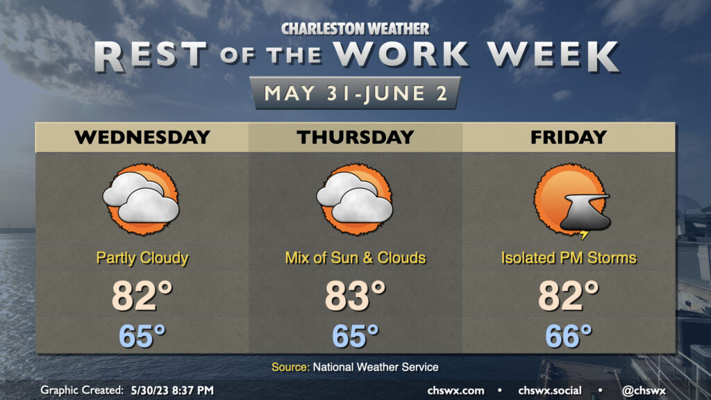
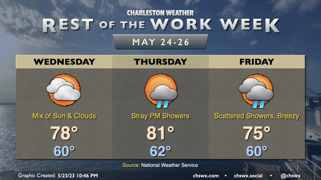
The forecast for the rest of the work week is pretty straightforward: a mix of sun and clouds each day, with temperatures starting the day around normal before topping out a few degrees below normal each afternoon. Highs will generally run in the low 80s after starting each day in the mid-60s, somewhat unusually “cool” for the end of May and beginning of June. Precipitation chances will be minimal Wednesday and Thursday, with a slight chance of an evening thunderstorm on Friday.
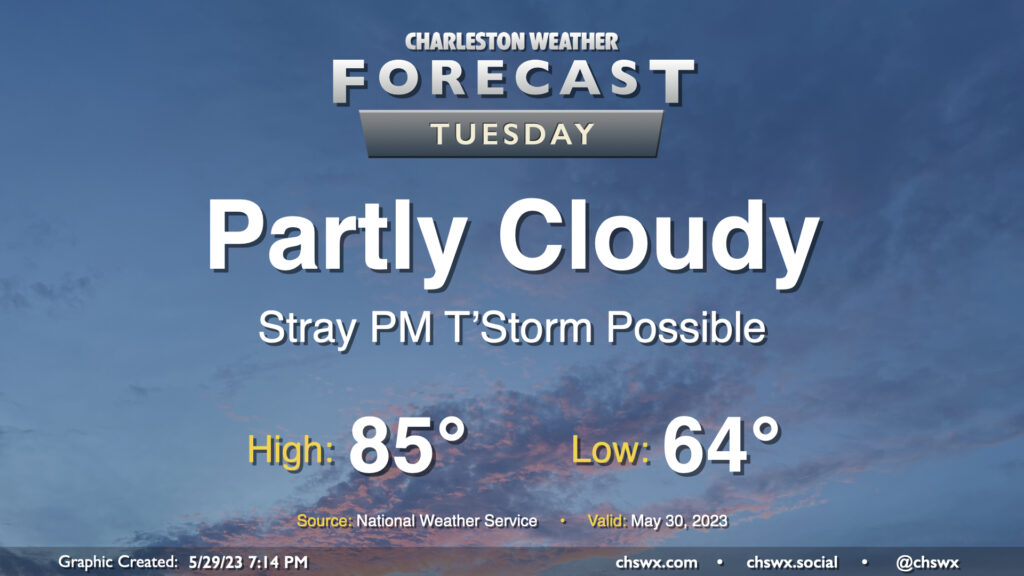
After what’s turned out to be a really beautiful Memorial Day, we head back to work and school on Tuesday with similar, if not slightly warmer, weather expected. We’ll start the day a few degrees warmer — generally around the mid-60s — and highs should warm to the mid-80s in the afternoon. There’s a risk for a stray shower or thunderstorm in the later afternoon and early evening hours as the seabreeze gets rolling, but otherwise, the vast majority of us get Tuesday in rain-free as well.
Our run of unusually cool late-May weather continues through the end of the work week as high pressure continues to wedge into the area from the northeast. Wednesday should look a fair bit like Tuesday did, but with even more dry air that should preclude any popup showers. After a seasonably cool start around 60°, highs look to top out in the upper 70s with a mix of sun and clouds with northeasterly winds around 5-10 MPH.
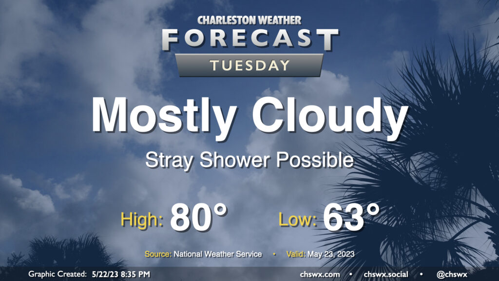
Cool high pressure remains in control for Tuesday bringing partly to mostly cloudy skies and highs well below mid-to-late-May normals. We’ll start the day in the low 60s before temperatures head to just about 80° in the afternoon — we’re normally looking at highs in the mid-80s at this point in the year. A stray shower could develop in the afternoon, but models show a pretty deep dry slot aloft that should preclude widespread precipitation.
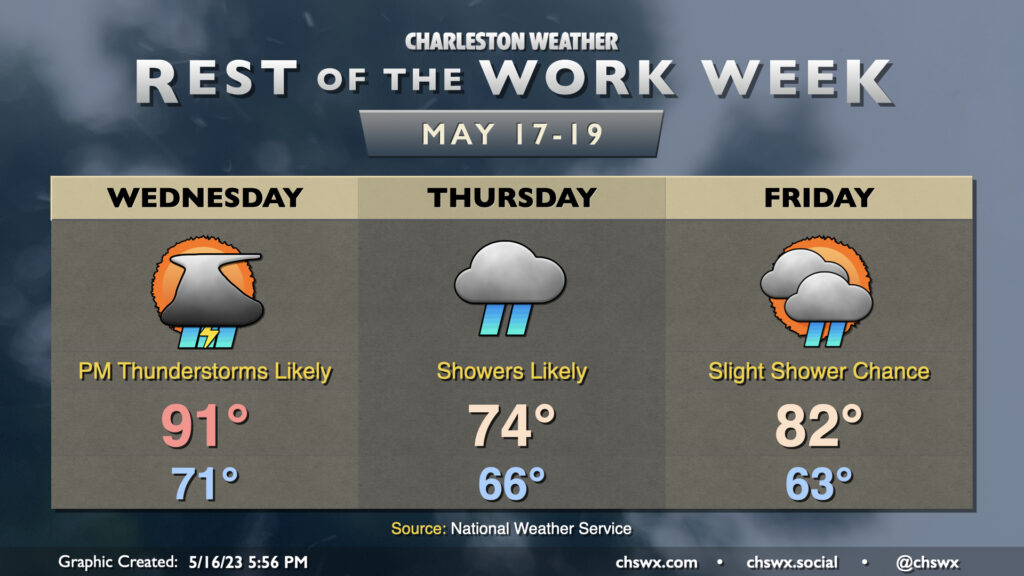
The rest of the work week will be on the unsettled side as a cold front moves back into the area from the north. Wednesday will, by far, be the warmest day of the set as highs top out in the low 90s before showers and thunderstorms initiate by mid-afternoon. Heavy rain will be possible within thunderstorms, and some minor flooding can’t be totally ruled out where storms set up. Severe weather is unlikely, but a sporadic damaging wind gust or two can’t be totally discounted.
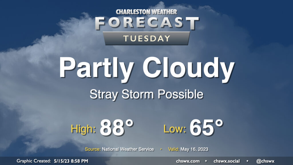
A warm front will lift north of the area tomorrow, bringing in even warmer and more humid air for Tuesday. Much of the day should stay rain-free with relatively weak instability, though a stray shower or storm near the seabreeze can’t be discounted. If a storm or two does form, note that storm motions will once again bring them toward the coast, so be aware of that if you have a Tuesday beach trip planned. (Lucky duck.) Expect highs to top out in the upper 80s; I wouldn’t be shocked to see a 90° reading somewhere, either.