We’ll be warming up as the week goes on — the last full week of March, already! — with isolated to scattered showers and storms possible beginning Tuesday night. The next significant storm system on the docket is expected to arrive sometime Thursday or Friday, but persistent low pressure keeps rain chances in the picture well before that.
Gusty winds will continue overnight into Monday, with 30-40 MPH gusts possible near the coast and on bridges. This is due to a tight pressure gradient between a wedge of high pressure inland and a surface low migrating northeastward off the coast. Northeast winds look to relax a little on Tuesday, but could still be gusty at times near the coast. A High Surf Advisory and a High Risk of Rip Currents is in effect for Monday — not a great beach day, for sure.
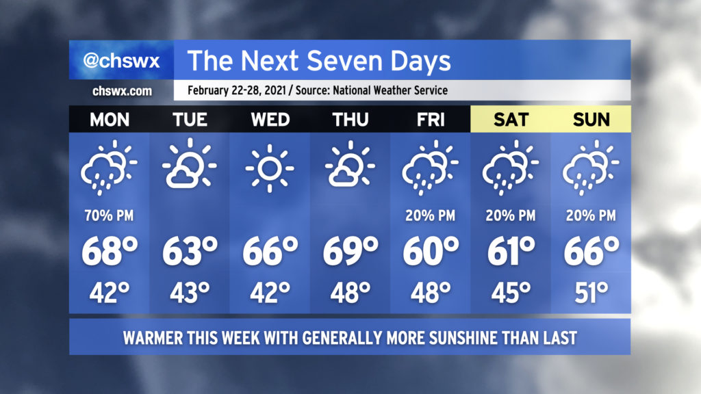
Unsettled weather returns to the picture this week as a series of fronts stall out across the area, bringing shower and thunderstorm chances starting late Monday into much of the rest of the week. Temperatures will be on quite the rollercoaster as well; after topping out at 80° today, we drop back to 61° for Monday as a cold air damming wedge builds southwest across the area, bringing cooler air and gusty northeast winds. Moisture will increase throughout the day, and we will begin to see showers possibly as early as Monday evening, with better rain chances arriving overnight into Tuesday.
After the stalled cold front lifts back north across the area as a warm front on Tuesday (and there is a big question on just how far north it will lift, perhaps making 71° a tad optimistic), low pressure will traverse the area, keeping showers and perhaps a thunderstorm or two in the forecast into Wednesday. We could see a line of strong to even severe storms swing through the area ahead of a cold front on Thursday; this will certainly be something to watch over the coming days, but it’s impossible to nail down the details this far in advance given consequential model timing differences (as one would expect at this range).
By Friday, another cool wedge of high pressure looks to build in across the area from northeast to southwest, keeping cloud cover around and temperatures down in the low 60s, well below normal for mid-March. I wouldn’t be surprised to see some shower chances enter the picture near the coast on Sunday, but right now the NWS forecast is rain-free.
High pressure will be the main factor in our weather throughout the week, keeping things dry and warming us up to the upper 70s for at least the first part of the weekend.
A freeze is expected inland of Highway 17 tonight, with scattered to widespread frost elsewhere. Be sure pets and plants are protected; if you live further inland, consider dripping a faucet as temperatures could dip into the upper 20s there. Frosty conditions will be possible again on Tuesday morning across much of the area, and a Frost Advisory may be needed.
Otherwise, though, expect temperatures to gradually warm up as the week goes on. High pressure will slip offshore, and the southerly return flow will help temperatures rise into the 70s by mid-week. There will be clouds from time to time, but no measurable rain is expected for several days. Our next chance of rain could come Sunday, but that is even right now at such a low probability that it isn’t mentioned in the NWS forecast.
We begin meteorological spring with one more day in the 70s and increasing rain chances ahead of a cold front. The front will push southward across the area late Monday, leaving us significantly cooler for Tuesday and beyond. (I hope you’ve not put your sweaters away yet!)
The cold front will stall somewhere near the Gulf Coast, and low pressure will spin up and traverse it. Rain chances will come up ahead of this low pressure system later Tuesday, with widespread showers expected on Wednesday. Once low pressure departs, we should get a couple dry days in before a coastal trough possibly generates a few showers in the area on Saturday afternoon. High pressure is projected to usher this trough away from the area for Sunday.
I suspect the temperature shift back to below normal is going to be a bit of a jolt, especially after closing February with a weekend featuring highs in the 80s each day. Normal highs for the first week of March are around 66-67°, and it just doesn’t look like we’re going to get there this week.
Rain chances will make a brief return to start the week, but without the ridiculous tap of moisture that characterized the last few rainstorms. The recent deluge has led to river flooding in spots on the Edisto as well as on the Santee at Jamestown, with homes being threatened in Ridgeville. Overall, though, expect a quieter week of weather with warmer temperatures than we’ve been used to.
As mentioned before, Monday starts ahead of a cold front with scattered showers coming onshore for a fair bit of the day. However, the best chance of showers will be in the afternoon and evening hours as the front passes. Temperatures will rise into the upper 60s and could even crack 70° in a few spots.
Tuesday through Thursday look really nice, with ample sunshine and progressively warmer temperatures, again potentially touching 70° on Thursday.
Our next rain chance arrives Friday afternoon in the wake of another front. Isolated showers will be possible each afternoon through the weekend, but right now we should not see any washouts. Temperatures will remain near or slightly above normal.
This is the last week of meteorological winter; meteorological spring begins on March 1st. (Meteorologists and climatologists use March 1 to mark the start of spring as it is a consistent point for record-keeping. The vernal equinox, which ushers in the more traditionally accepted definition of spring, is on March 20.)
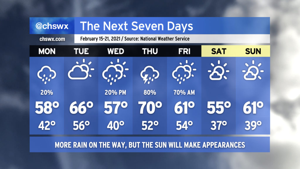
It’s been quite a soggy weekend, with rain totals in many spots exceeding 1″ just today as seemingly relentless moisture pushed atop a cold air damming wedge, keeping the weather wet and chilly as temperatures have barely left the low 40s over the past two days.
Well, the good news is that things are changing, and that we will even see the sun at times this week! (The weekend looks good, too!) But, there will be more unsettled weather before it’s all said and done.
Enjoy the rain-free conditions on Monday, because we’re back to wet weather at times through perhaps Sunday morning. Temperatures will at least run at or a little above normal for much of the week with zonal flow and perhaps even a little ridging aloft, keeping a well-advertised intrusion of Arctic air for much of the northern continental United States at bay for at least the next several days.
The current forecast shows rain chances diminishing Saturday and Sunday in the wake of a cold front, with below-normal temperatures for Valentine’s Day. It’s worth noting that there is a fair bit of model spread as we get into the weekend, so be keeping an eye on forecast updates as some details will need to be fine-tuned.
Despite some of the apps’ best attempts this past Friday, winter weather is not indicated in the forecast, and there is decreasing support for this scenario unfolding from the ensemble of global model runs as the southern extent of a potent Arctic air intrusion into the continental United States appears to be retreating significantly. There has been a noted bias in the models when they get out to the longer range to try to bring Arctic air much further south than it ultimately ends up, and so far, this appears to be one of those times. If things change and it looks legit, I and the rest of the #chswx enterprise will be sure to let you know! 🙂
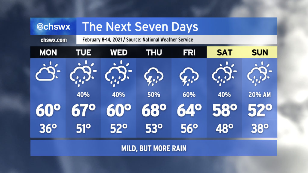
We will begin February much as we spent about half of January: Chilly, cloudy, with occasional showers in the area. Fortunately, showers will depart for mid-week, as chilly high pressure runs the show through Thursday. Watch for some frosty and freezing temperatures mid-week before a warming trend commences Thursday afternoon. By Friday, we’re scraping 70° again as we return to the warm sector ahead of our next storm system, with showers becoming possible late in the day. Timing of our next front is somewhat suspect, so you’ll want to keep an eye on the forecasts for the weekend in anticipation of adjustments to rain chances and temperatures.
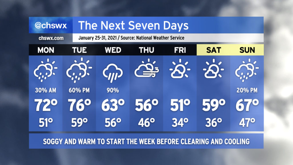
The final week of January 2021 (already!) will start off fairly warm before returning to below-normal temperatures to head into the weekend. Forecasted highs in the 70s on Monday and Tuesday would be the first 70+ temperatures since January 1-2. This abnormal warmth will be swept away with a soggy storm system come Tuesday evening into Wednesday, though, bringing in cooler and drier conditions to close out the week. Then, the progressive pattern ushers in another storm system to possibly bring some rain and warmer temperatures back to the area as early as Sunday.
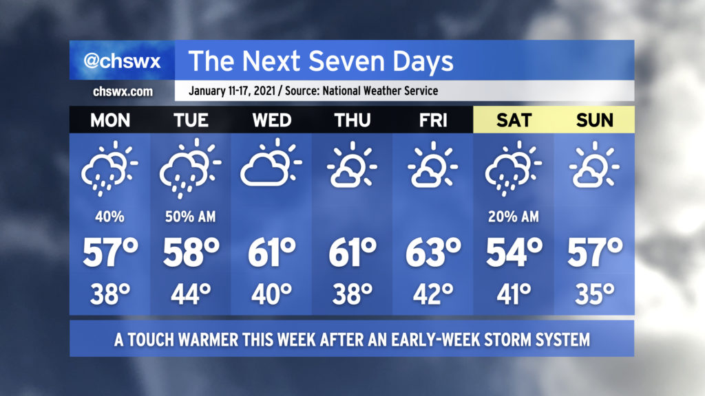
The week ahead will be characterized with a few showers to start before warming up and clearing out in the second half. Clouds will increase overnight into Monday, with showers potentially developing over the ocean and moving inland starting in the afternoon. Shower chances will continue into Tuesday as a wave of low pressure affects the area. Once the disturbance clears the area, we’ve got a few nice days to close out the work week, with temperatures topping out in the low 60s each afternoon. A cold front will swing through early Saturday that may bring a shower or two, but other than that, we’ll cool back to around or a little below normal for the weekend.