The first work week of 2021 will generally arrive with little weather fanfare, with temperatures at or slightly above early January normals for much of the week. Rain chances tick up Thursday into Friday as a storm system moves through, but quiet weather returns for the weekend.
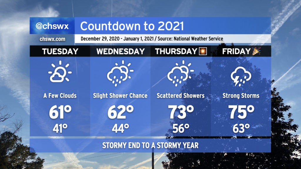
2020 looks to hand off to 2021 in the fashion we would expect from this year — a bit on the warm and stormy side — as a cold front approaches the area from the west.
The last few days of the year will get progressively warmer, with 70s back in the picture for New Year’s Eve. Rain chances also return beginning Wednesday, with a shower or two possible as a coastal trough moves inland in response to high pressure to the northeast breaking down and moving out. Rain chances improve for Thursday along with a noticeable jump in temperatures (70s!) as warm and moist air overspreads the area ahead of our next storm system.
Overall, if you’ve got things to do outdoors, Tuesday’s your best day to for-sure avoid rainfall. As for New Year’s Eve, I’m not expecting a washout for fireworks displays as of now, but the devil is in the details. Stay tuned.
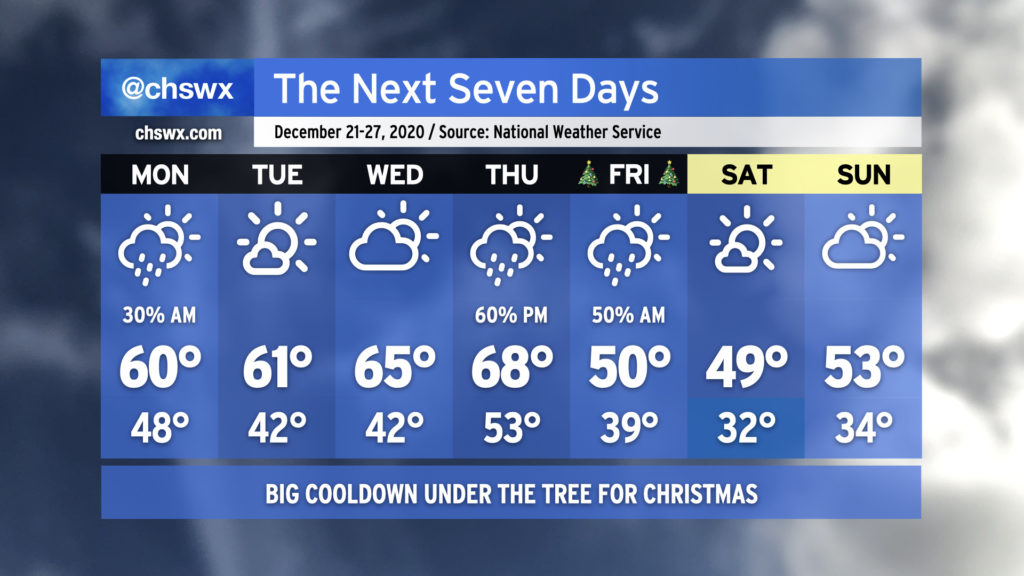
We’ll start the last few days before Christmas a little warmer than we have been of late, but Santa has cold high pressure for us for Christmas and beyond as we get into the holiday weekend.
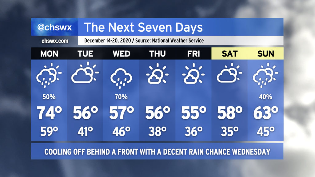
After what ended up being a fairly nice weekend, we have one more day in the 70s before we’re back to more seasonable — if not a bit below-normal — temperatures across the Lowcountry for the last full week before Christmas. (Yes, it’s almost Christmas. It’s shocking to me, too.)
A cold front will swing through Monday, bringing a chance of showers to the area generally from mid-morning to early afternoon. High pressure will wedge in behind it, cooling us off but also keeping some cloud cover around for Tuesday. Another storm system will ride up the coast Wednesday, potentially turning into a decent nor’easter for the Mid-Atlantic states and New England. We’ll see mostly sunny skies with continued chilly temperatures to close out the work week. Clouds increase for the weekend, with perhaps some showers on Sunday.
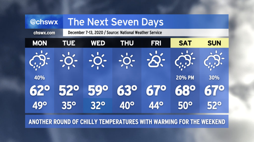
Another week in December, and another round of freezing temperatures in the cards for mid-week. We’ll start the week with some showers in the area as a cold front gets through the area early Monday, followed by some lingering shower activity as a trough of low pressure hangs around behind the front. Once the low clears the area, temperatures really begin to fall off, and we’re back in the 50s on Tuesday after dipping into the mid-30s, well into “bring pets and plants in” territory. Expect another freeze Wednesday morning away from the immediate coast before temperatures rebound to near 60°. Mostly sunny skies continue Thursday and Friday as temperatures begin to moderate back around normal (mid-60s) for the second week of December. Then, a cold front approaches the area over the weekend, bringing some slight shower chances to the area Saturday and Sunday.
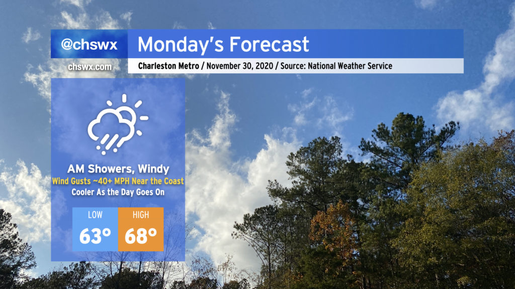
We’ll get this week off to a rainy and windy start as the storm system which rained on us for a fair bit of today moves through the area on Monday, ushering in the coldest air of the season in its wake.
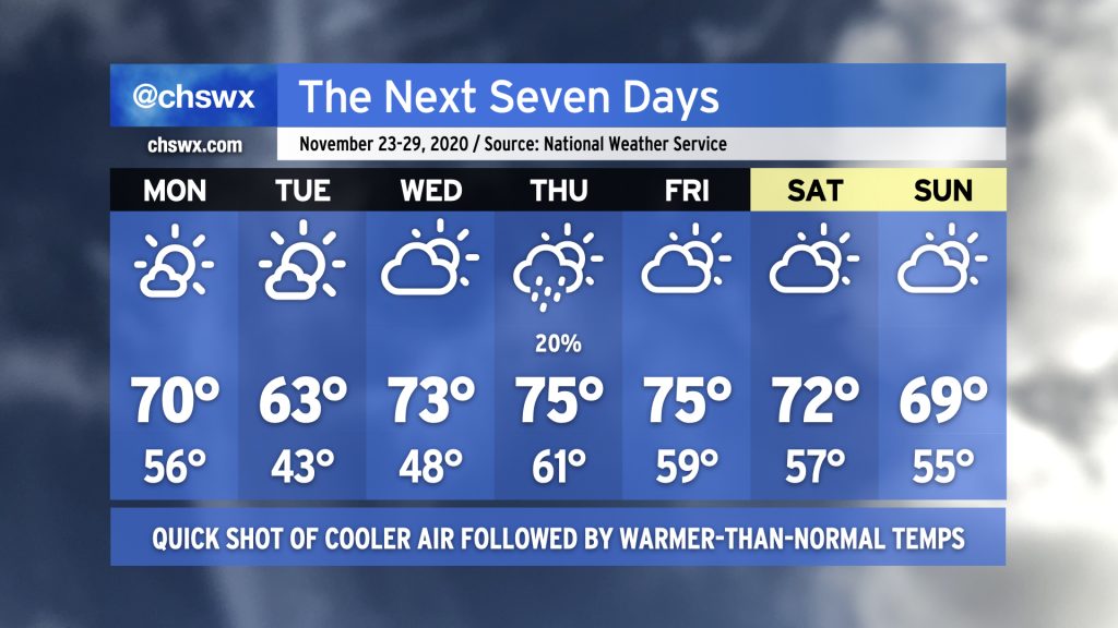
Aside from Monday evening into Tuesday, Thanksgiving week will shape up a bit on the warm side, with a few showers for Thanksgiving Day possible.
Overall, the pattern will be pretty progressive this week. We’ll start the week with a cold front swinging through during the day Monday. This will knock temperatures back into the low 40s by Tuesday morning, with highs only reaching the mid-60s during the day. High pressure quickly shifts eastward, though, allowing for temperatures to moderate (and clouds to increase) ahead of another front Wednesday. The next front looks to swing through Thursday into Friday, and this is where we may see a few showers develop. (Right now, chances are low.) Temperatures will then level off a little lower, with perhaps some rain chances toward the end of the weekend depending on the forward speed of another storm system.
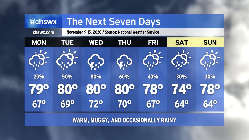
A cold front is swinging through the Southeast Sunday evening, which will bring a stop to the ridiculously humid weather we’ve been experiencing this past week. Temperatures will be right around normal to start the week under full sunshine. A reinforcing shot of cool air on Wednesday will knock us firmly into sweater weather territory, with moderating temperatures into the 70s for the weekend. The week looks to remain rain-free, which will be awfully nice after the tropical soaking we took last week.
Fall’s hiatus continues this week as we sit between high pressure to the north and Tropical Storm Eta to the south. Monday looks to be the driest day of the week with just a slight chance of showers throughout the day. Rain chances head up into Wednesday as tropical moisture associated with Eta gets drawn up into the area by a frontal system approaching from the west. This front looks to stall out by the end of the week, keeping a chance for showers in the forecast through the weekend. (Eta could make the weekend a little more wet and windy, so consider that forecast somewhat low-confidence at the moment.)
Temperatures will remain rather warm for early to mid-November. NWS notes that some record high minimum temperatures could fall this week, with lows in the 70s forecasted especially Wednesday and Thursday. (For contrast, the typical high temperature this time of year is around 71-72°.) Highs will generally run in the upper 70s to low 80s, roughly 8-10° above normal for this time of year.
If you’re looking for a shift back into Fall, this week ain’t it. While we may cool off as we get into the following week, long-range guidance continues to hit on above-normal temperatures remaining the norm (as one would expect in a La Niña winter, which tends to trend warmer and drier in the Southeast).
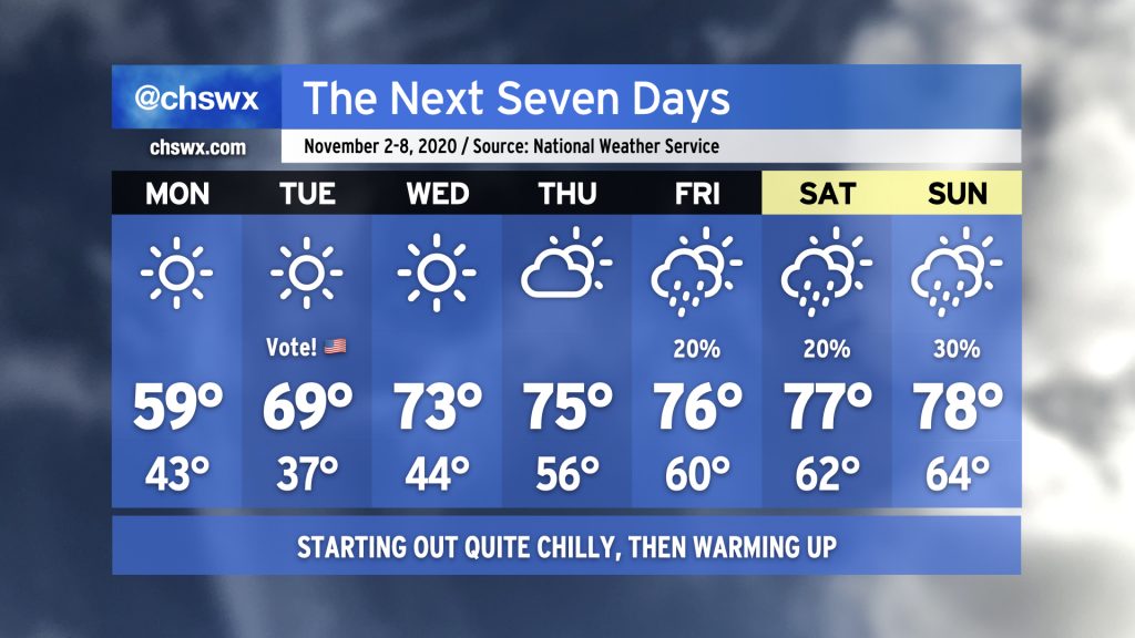
Get your sweaters ready, at least for Monday and Tuesday morning: A cold front swinging through tonight will usher in the coolest airmass of the season thus far. The high of 59° forecast on Monday would be the coolest high since early March, and this is happening despite full sunshine. We could see some frost develop away from the barrier islands Tuesday morning as temperatures dip into the 30s. We’ll rebound to near 70° in the afternoon under mostly sunny skies, making the weather a non-impediment for Election Day.
Temperatures recover fairly quickly as we get into mid-week; we’ll be up into the 70s by Wednesday, and that continues for the rest of the week. We’ll gradually see a warmer and more humid airmass get into the area, with lows creeping up into the 60s by the weekend. Isolated to scattered showers become possible later this week, but so far, not seeing a prolonged rain event.