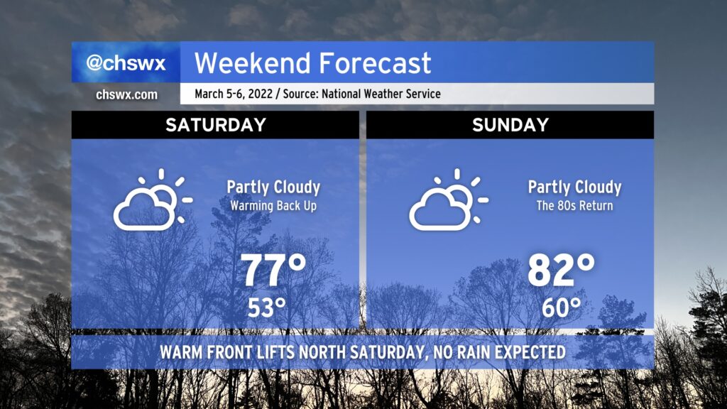
After a brief interlude on Friday thanks to a cool wedge of high pressure building into the area, warmth and sunshine returns Saturday as the front lifts back northward as a warm front. Like the cold frontal passage last night, we’ll remain rain-free as the warm front lifts northward.
With the wedge airmass out of here, temperatures jump back to the mid-to-upper 70s by Saturday afternoon, and we’ll warm even further toward the low 80s on Sunday. The record high for March 6 is 85°, and we might get within spitting distance depending on how much heating can develop.
Warm weather will continue into Monday with near-record highs possible again. Beyond that, things take a turn for the unsettled for much of the next work week with temperatures running a little cooler (but still above normal).
For the third consecutive day, we at least tied the record high at Charleston International Airport. Today’s high was 86°, which matches 2018’s record temperature. Changes are coming, though, thanks to a cold front which will bring this run of record highs to an end.
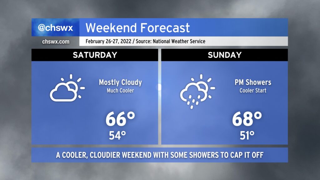
Temperatures on Saturday should run some 10-20° cooler in spots in the wake of the aforementioned cold front. The front itself will come through dry, but expect an uptick of cloud cover behind it on Saturday. Highs in the mid-60s will be common (and much closer to where we should be at this point in the year).
Unfortunately, this weekend doesn’t get in rain-free; expect showers to develop starting Sunday afternoon as an upper-level disturbance ripples through. Highs will top out in the mid-to-upper 60s across the area, though showers could put a damper on that later in the day.
Heading into next week, temperatures will remain around if not a few degrees above normal — though certainly nowhere near the record levels we experienced this week. All in all, above-normal temperatures remain strongly favored as we head into March, but never underestimate the power of one last March freeze to cause problems to start the growing season.
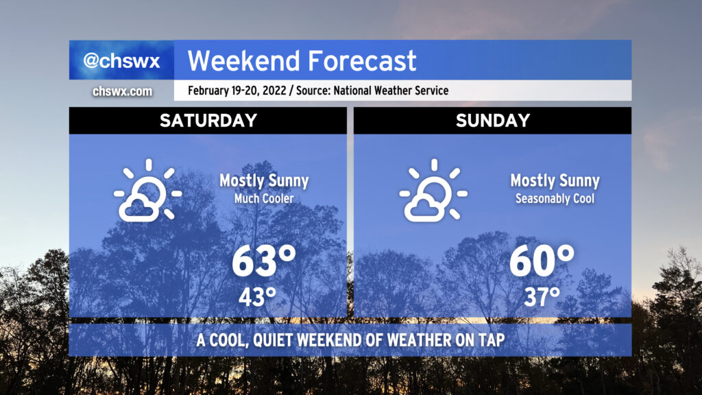
No weather concerns this weekend as high pressure is the main weather factor across the area. Temperatures will run much cooler than they did today — for crying out loud, we reached 80°! — but will feel much more seasonable overall for mid-February. There will be plenty of sunshine in the area, but the cooler airmass keeps highs in the low 60s on Saturday and perhaps struggling to reach 60° on Sunday. Overall, though, it’s solid sweater weather without the rain gear, and that isn’t bad for a big SEWE weekend in the Lowcountry.
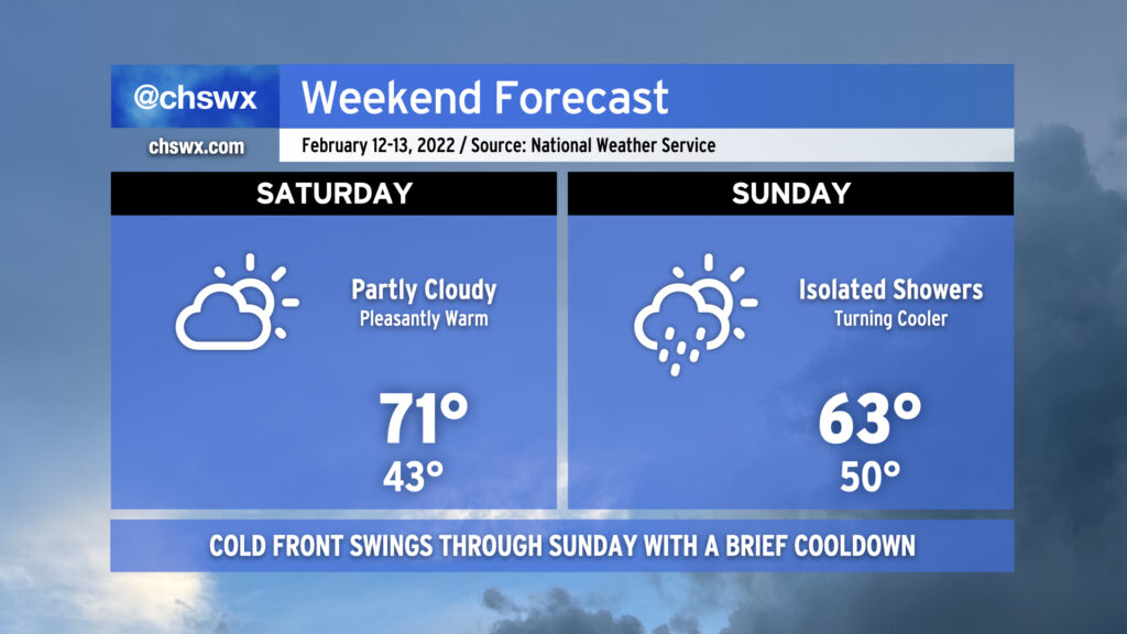
The weekend’s weather will turn on a cold front on Sunday. Saturday’s certainly the better day to get out and about with highs topping out in the low 70s despite increasing cloud cover. The cold front should get through the area sometime Sunday morning, accompanied by a wind shift to the northwest. Showers will be possible ahead of and around frontal passages, with slight shower chances indicated from early Sunday morning through the early afternoon hours. Sunday’s forecast high temperatures will be reached in the early afternoon before steadily falling for the rest of the day as cooler and drier air advects into the area. This airmass will make us all feel like we got the cold shoulder on Valentine’s Day, but temperatures will warm quickly thereafter, with a return to the 70s by late next week.
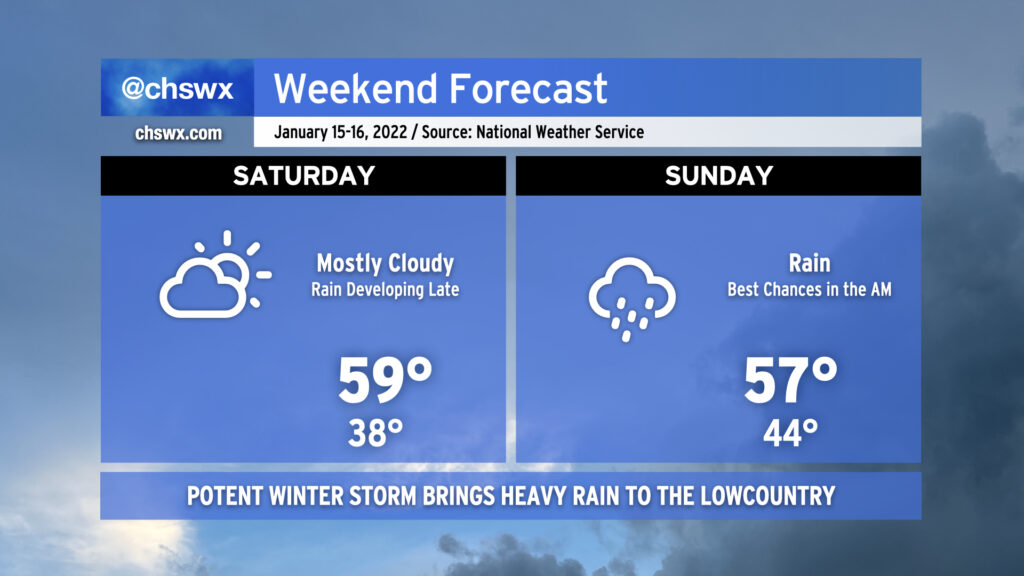
A relatively quiet Saturday will give way to a somewhat turbulent Sunday as a potent winter storm brings heavy rain to the Lowcountry. Temperatures on Saturday will generally run in the upper 50s as cloud cover increases as the storm approaches from the west. We should get much of Saturday in rain-free, with the better rain chances arriving at and after midnight.
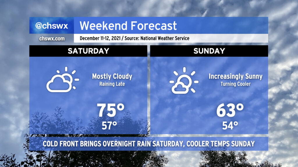
A warm front will continue to lift north across the area tonight, eroding a wedge of high pressure and setting us up for an unseasonably warm Saturday. We may start with some patches of fog during what will be a very mild morning, with lows only bottoming out around the mid to perhaps upper 50s. (The normal high for December 11 is 63°!) We’ll keep a mix of clouds and sun around as breezy southwest winds help pump in warmer air ahead of an advancing cold front. This will allow highs to top out in the mid-70s, 10°+ above normal.
Late Saturday into early Sunday morning, the aforementioned cold front will move through the area, bringing with it a weakening line of showers. It doesn’t look like we’re getting much in the way of rain out of this, so there are no real concerns as the line crosses the area. It should be out of here by daybreak Sunday (exact timing TBD), bringing a cooler airmass along with it. Highs will be right on the line for normal for December 12 on Sunday as clouds scour out, bringing us a sunny finish to the weekend.
Whatever rain we get overnight Saturday/early Sunday looks to be the only precipitation we’ll see for the next several days as our very La Niña-esque cool season rolls on. Enjoy the weekend!
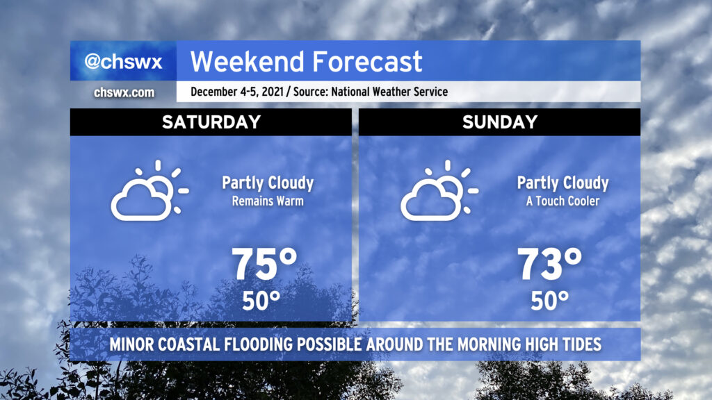
High pressure remains in control of our weather over the weekend, keeping partly cloudy skies in place and unseasonably warm temperatures in tow. We look to return to the mid-70s Saturday after starting out around 50°, weather that is more reminiscent of October than December. We keep this in place on Sunday, with highs perhaps coming in a couple degrees cooler as a cold front gets nearby (but not through the area, it looks like).
The only weather worry will be the risk for minor coastal flooding with the morning high tides on Saturday, Sunday, and possibly into Monday as the new moon at perigee brings us another round of king tides. High tide on Saturday morning arrives around 7:32am and on Sunday at 8:26am. Minor flooding can close a few roads around downtown Charleston, particularly near the Citadel and the City Market, but these disruptions should be easy to bypass. (It’ll be nothing like what we saw around this time last month, that’s for sure!) Keep an ear out for Coastal Flood Advisories from the National Weather Service and avoid roads covered in salt water as that’s nasty for your car.
We’ve got another chilly night ahead; temperatures could scrape freezing at a few spots by Saturday morning, so be sure you’ve got sensitive plants still protected and your pets have a warm place to be overnight.
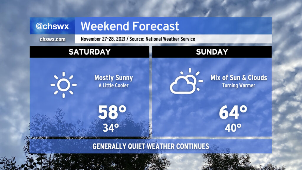
Saturday will run a little cooler than today did in the wake of a cold front that came through earlier today. After starting the day around freezing (with wind chills making it feel about 3-5° colder), highs will top out in the upper 50s despite mostly sunny skies. Winds look to be generally light throughout the day with a shift in direction to the southwest late.
Sunday will feature more clouds but will also be warmer thanks to westerly winds ahead of another weak cold front poised to come through early Monday morning. Temperatures will rebound to the mid-60s in the afternoon after starting around 40°, making for a seasonably comfortable late November day in the Lowcountry.
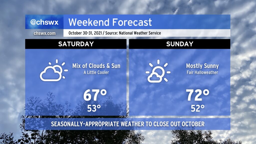
The potent upper low which helped drive through a front with heavy rain and gusty winds yesterday remains over the Southeast through this weekend, keeping temperatures on the cool side and cloud cover a little elevated, particularly on Saturday. We’re very likely not to get out of the upper 60s on Saturday given the mix of clouds and sun that’s expected. (You might want a sweater, at least for a bit!)
Sunday will run a touch warmer and a little sunnier, too, making for a rather pleasant Halloween free of weather-related frights. Nice weather on a warming trend looks to continue for the first few days of November, too. Enjoy your weekend!
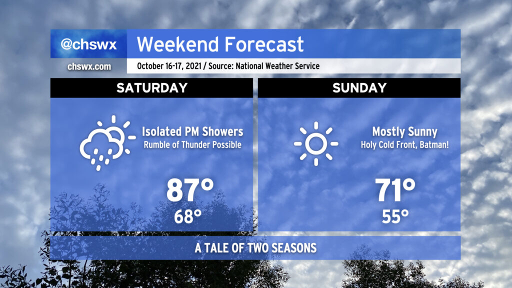
Get ready for a change in seasons this weekend. After a record high of 87° today at the airport, we’ll climb back into the upper 80s for Saturday as a cold front approaches the area. A few showers and maybe a rumble of thunder or two will be possible as the front gets closer, but the general thinking is that there just won’t be the moisture for more widespread rainfall.
Fall fans, rejoice: We will wake up to a significantly more fall-like feel on Sunday morning with lows bottoming out in the low to mid-50s. Much cooler and drier air will continue to move into the area throughout the day, yielding clear skies and highs only topping out in the low 70s despite uninterrupted sunshine. We may see our first 40s of the season in the metro area on Monday morning, too, before a slow warming trend commences for the rest of the upcoming week.