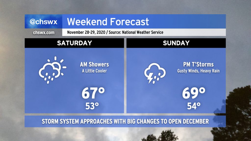
While it’d be unfair to characterize the weekend as a washout, we do face periods of unsettled weather as a frontal boundary remains stalled to our south in Georgia and a potent storm system approaches the area from the west.
Saturday morning, expect light rain to move across the area as a wave of low pressure along the stalled front moves from west to east with a little upper-level support to boot. It’s not likely that we’ll see much more than a tenth or two of an inch of rain across the Lowcountry from this round of rain, and it should conclude by early afternoon. We should get at least a few peeks of sun before Saturday’s all said and done, and the evening will remain dry. Temperatures will run a little cooler than previous days, only topping out in the upper 60s.
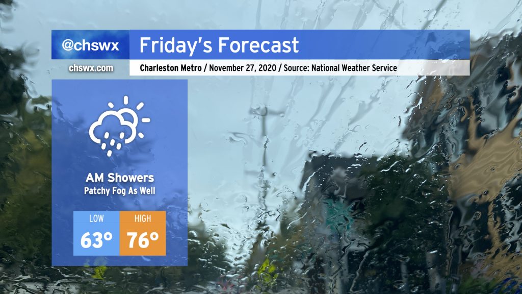
We’ll start the Friday after Thanksgiving with some showers as a cold front slowly trudges through the area. Once this front is through, rain chances will decrease and we should have a fairly nice afternoon, with temperatures still running well above normal in the mid-70s — though not quite getting to 82° like we did today.
After the last two weekends of agonizing over the potential for severe weather in the Lowcountry, a quiet weekend is more than welcome. There will be slight chance of a shower or storm on Saturday afternoon as a cold front swings through, but moisture return is meager and so just an uptick in cloud cover is expected.
Sunday looks pretty great for a change — partly cloudy to mostly sunny skies with highs topping out right around 80° will make for a much nicer day than we’ve had the past couple Sundays. Take advantage as best as you can given our continued socially-distant circumstances!
While damage surveys continue from this Monday’s tornado outbreak, we begin to look ahead to the upcoming weekend, which may hold another severe weather threat as we roll on into Sunday afternoon and evening.
Did you like today? Excellent — there’s more on the way for Saturday as temperatures top out in the mid-70s once again under mostly sunny skies. High pressure will then slip into the Atlantic turning winds more onshore for Sunday, boosting humidity a little and providing for more partly cloudy skies, but comfortable temperatures in the mid-70s continue.
Only things to watch out for this weekend (besides coronavirus!):
Weather conditions will be conducive to wildfires through Saturday afternoon. Postpone any outdoor burning so that things don’t get out of hand in an already stressful situation.
Some minor tidal flooding may be possible with the Sunday morning high tide around 6:13am. As of this writing, the NWS forecast prediction is for tides to top out around 7′. This would cause some minor flooding in places such as Lockwood Blvd. and the intersection of Hagood and Fishburne streets near the Citadel and MUSC.
Otherwise, this weekend’s weather will be enjoyable even if the circumstances aren’t so hot. Try to get outside — it will be good for your soul.
Our abnormal warmth will continue for one more day on Saturday before showers enter the picture during the afternoon ahead of a cold front. Said front will push south of the area sometime late Saturday/early Sunday, and with that will come chilly high pressure wedging south. This, combined with periodic rain from moisture overrunning the high pressure wedge, will keep Sunday’s highs in the upper 60s at best. Rainfall amounts will generally be confined to a quarter-to-half-inch in most spots, so nothing too out of hand — just more drink for the garden.
After a high of 83° made today the warmest day of 2020, we will be cooling off substantially this weekend as a backdoor cold front moves through overnight Friday/early Saturday morning. This will turn winds to the northeast and kick up the cloud cover, which will in turn keep temperatures down into the upper 60s for Saturday afternoon. It’ll feel like quite a difference from the three straight days of 80s we’ve had this week, that’s for sure.
Shower chances will increase as the day goes on Sunday as the front wobbles along to the south and a wave of low pressure develops to the west. Temperatures will once again be held to the mid-to-upper 60s in the afternoon with light rain in the area. It’s conceivable this could go a little lower, too, as these high pressure wedge setups often err on the cool side of things.
As has been customary this month, we get the weekend to chill out and dry off from the work week’s rainfall. Saturday looks to be probably the coldest morning of the season thus far, with lows in the mid-20s and wind chills approaching the teens. Highs will top out in the mid-50s under brilliantly sunny skies.
Sunday will once again be chilly with a few areas away from the immediate coast approaching the freezing mark in the morning. Despite a little more cloud cover, temperatures will rise nicely into the low 60s, just a hair below where highs normally land in late February.
True to form, our next rain chances arrive on Monday. For now, though, bundle up and enjoy the weekend!
We start this Valentine’s Day off with mostly cloudy skies and occasional patches of drizzle and light rain as a plume of moisture with origins in the Pacific pushes eastward over our area. Once said plume begins to clear, we will see clouds follow suit, giving way to a nice and somewhat cool afternoon. The big feature of today’s weather, which lasts through the weekend, is the return to cooler, more seasonable temperatures in the wake of a cold front which swung through yesterday. Expect highs today to top out in the upper 50s to low 60s across the area, a marked change from yesterday’s upper 70s inland to mid-70s near the coast.
Unseasonable warmth will continue through the weekend as the Charleston area remains within the warm sector of a rather potent storm system that is bringing heavy snow to Wisconsin and severe weather to Oklahoma, Texas, and Arkansas. Fortunately, we look to miss out on much, if not all, of the severe weather, but unsettled conditions will continue well into next week. A washout is not expected, but scattered showers will be possible from time to time.


