Thursday: More off and on storms, with a few possibly on the strong side

Thursday will be another active weather day across the region as a warm front draped across SC interacts with low pressure aloft to generate numerous showers and thunderstorms. A few of these storms could be on the strong side, with damaging wind gusts the main concern, though some hail can’t be ruled out either. Highs on Thursday top out in the mid-80s before storms get rolling once more. It won’t rain all day in any one spot, but when it does, it could be quite heavy. Keep rain gear handy, allow additional travel time, and keep an ear out for flood advisories as well.
Friday & the weekend: Calming down

The good news in this forecast is that as we get into Friday and the weekend, the upper low which has been plaguing us for several days will finally depart, bringing more typical June weather to the area for the weekend. Scattered to numerous thunderstorms will continue for Friday, though coverage should be decreasing as the evening wears on. Highs top out in the mid-80s once again.
There will be a noticeable downtick in thunderstorm coverage for Saturday as the upper low moves away and drier air works its way into the area. A more typical afternoon scattered thunderstorm regime is expected, with highs topping out in the mid-to-upper 80s.
Sunday will turn even warmer, with a return to the low 90s expected in the afternoon. Drier air lingers, and with little in the way of upper air support, thunderstorms will be few and far between.
Tropical update: Bret strengthens some, continuing to watch 93L

The National Hurricane Center continues to monitor Tropical Storm Bret, which should impact the Lesser Antilles tomorrow, as well as Invest 93L, which is following behind Bret and has a high probability of becoming a tropical cyclone in the next few days. The next name on the list is Cindy. Guidance ultimately takes it north of Bret’s track, but it should meet a similar wind shear-driven fate as we get into next week.
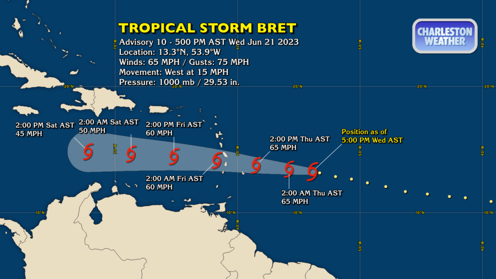
The 5PM advisory on Bret has it as a 65 MPH tropical storm, moving west at 15 MPH. This is likely around its peak intensity as it will run into progressively stronger wind shear as it continues to move westward. It’s forecast to reach the Lesser Antilles Thursday night into early Friday morning, bringing heavy rain and gusty winds to those islands. From there, the shear should be too great for Bret to stay organized, and the NHC forecast dissipates the system by the close of the day Saturday.
Neither Bret nor 93L pose a risk to the Lowcountry.
Follow my Charleston Weather updates on Mastodon, Bluesky, Instagram, Facebook, or directly in a feed reader. Do you like what you see here? Please consider supporting my independent, hype-averse weather journalism and become a supporter on Patreon for a broader look at all things #chswx!