Jared Smith founded @chswx on Twitter in 2008 as an experiment in disseminating weather data through social media. In the ensuing decade-and-a-half, @chswx has provided live coverage of tropical cyclones, tornadoes, severe weather, and even a couple bouts of winter weather to the good people of Charleston, SC.
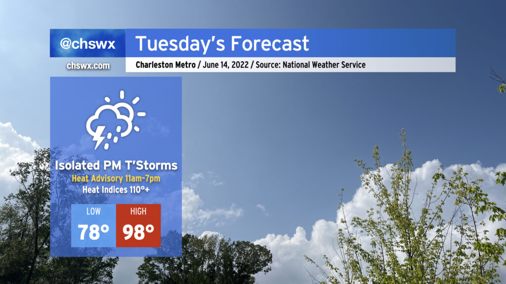
Another dangerously hot day for the Lowcountry is on tap for Tuesday, as temperatures soar into the upper 90s — and perhaps over 100° well inland — in the afternoon courtesy of an anomalously strong ridge of high pressure aloft. Factor in the humidity, and it’ll feel as hot as 110°+ during the peak of the afternoon, prompting a Heat Advisory from 11am to 7pm for the entire Tri-County area.
We haven’t seen heat like this in a long while. The last time air temperatures reached Tuesday’s forecast high of 98°, COVID wasn’t even in our vocabulary: it was August 10, 2019.
Looking for thunderstorms to help temper the heat? Don’t count on them, as coverage should be isolated at best. If storms do get going, they’ll be able to take off and become severe with damaging wind gusts and large hail. We’ll also be watching areas to our north with close interest tonight into tomorrow, as a potential mesoscale convective system could move into and through the Mid-Atlantic states during the day. This could help drive a cold front southward, bringing with it perhaps a better shot at some showers and storms later in the evening. These, too, could be on the strong side. The Storm Prediction Center outlines the area in a marginal (1 out of 5) risk for severe storms Tuesday.
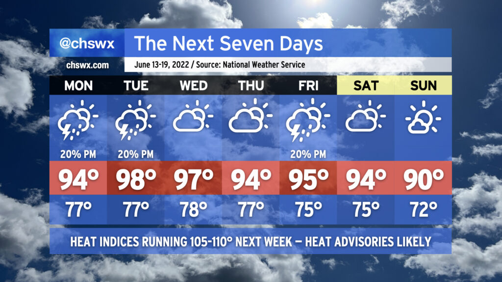
Oppressive heat looks to continue for much of the rest of the week, with a slight downshift in intensity Thursday and Friday (but not enough to elude more Heat Advisories). Mercifully, this heat wave should break on Sunday after another front pushes through the area and actually cools things off somewhat. But for now, make sure you’re getting plenty of shade and water if you must be outside in the afternoon.
Coastal flooding will continue to be an issue as well around the times of evening high tide. Watch for the potential for road closures each evening, and be on the lookout for Coastal Flood Advisories from the National Weather Service.
The hottest weather thus far in 2022 will arrive this week as a strong ridge of high pressure builds over the Southeast. The heat wave will peak Tuesday and Wednesday, with highs in the upper 90s expected and heat indices likely exceeding 110° both days. We stay hot heading into the weekend before a frontal system looks to push through Saturday night, leaving us with slightly cooler temperatures — if you could call 90° “cooler” — for Sunday.
Compounding things, low temperatures will struggle down to the mid-70s on the coolest mornings. There may be some mornings near the coast where temperatures don’t drop below 80°. The heat during the day with the lack of cooling at night will make for an oppressive few days. Check on your neighbors, especially those with vulnerability to the heat, during this tough stretch. Make sure you’re getting plenty of water and taking frequent shady breaks if you’ve got to be outside during the peak of the afternoon.
Thunderstorms will be few and far between for much of the week, with the better rain chances likely overnight Saturday into early Sunday morning with the frontal passage. Even then, right now the rain probabilities are in the 20-30% range.
Finally, astronomical factors and favorable winds will combine for minor to moderate tidal flooding with each evening’s high tide. Be ready for road closures in a few spots in downtown Charleston at times this week, and keep an ear out for Coastal Flood Advisories from the National Weather Service.
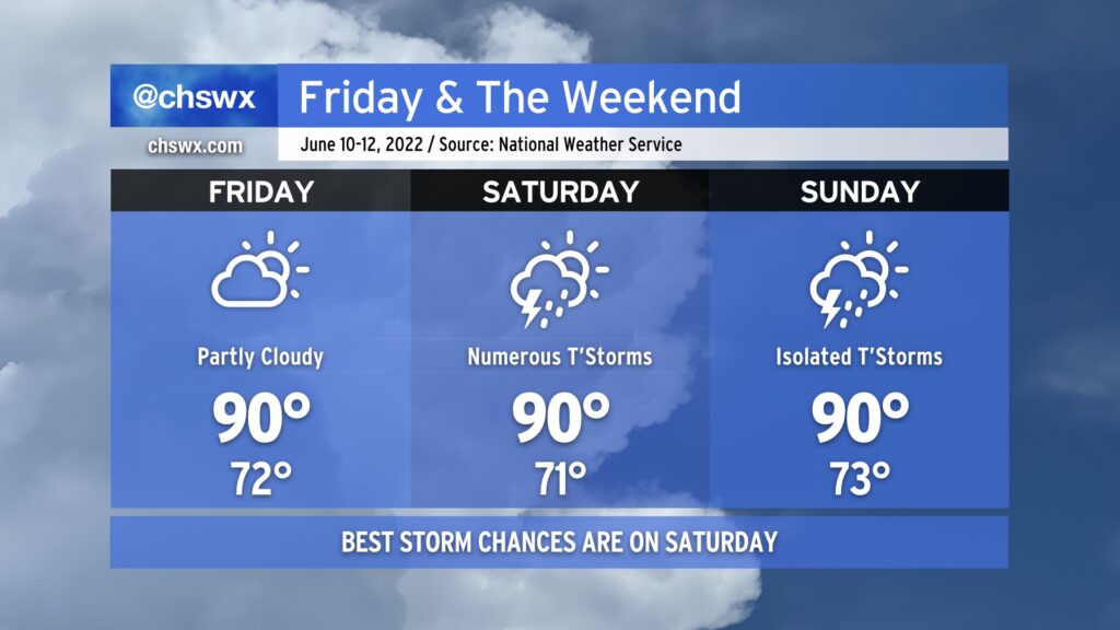
Friday and the weekend will remain on the warm side, with the best chance at showers and thunderstorms coming on Saturday before tapering off on Sunday.
We’ll be the beneficiary of some drier air on Friday, which should help keep thunderstorms to a minimum and put a little governor on the humidity. This will be short-lived, though, as the front that helps to usher in this drier air lifts back north of the area, putting us back in the soup on Saturday. It looks like showers and thunderstorms will begin to break out by mid-morning and continue well into the evening hours. Exact placement of storms will be driven by where storms initially fire and the subsequent propagation of outflow boundaries and the seabreeze. The trough driving some of this unsettled weather begins to lift north on Sunday, leaving us with generally standard chances of thunderstorms on the seabreeze in the afternoon.
Overall, expect highs around 90° each day ahead of thunderstorms, with heat indices generally in the mid-90s. This’ll feel cool compared to what’s coming down the pike for next week — it looks like we might have a few days of near-heat advisory conditions (heat indices 105°+) with little in the way of storms to help cool things off at least temporarily. We’ll want to watch trends closely for this potentially sweltering heat!
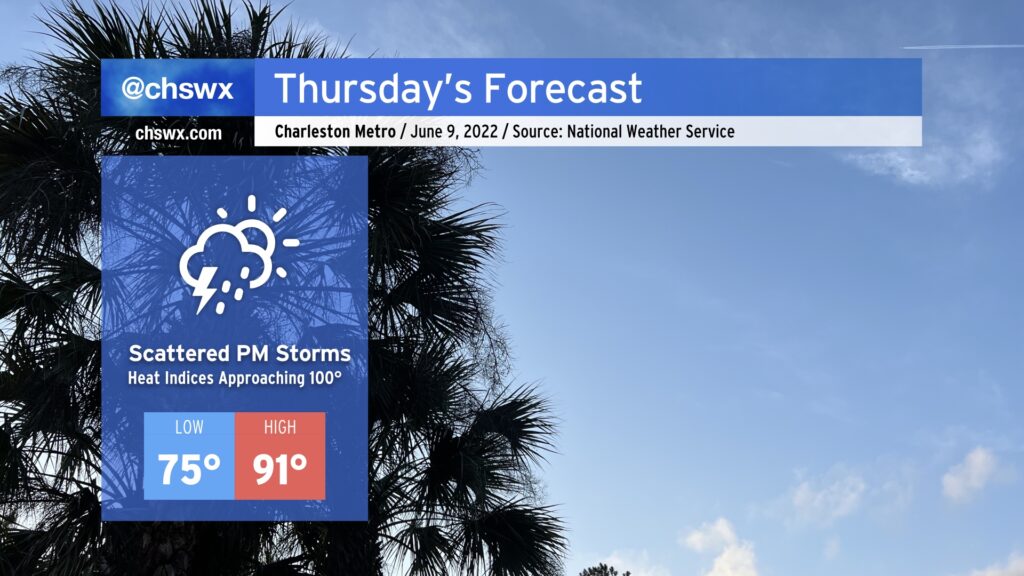
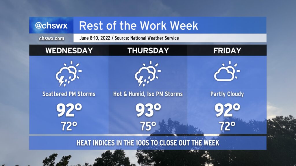
Despite the air temperature topping out around 91°, Thursday’s going to be the hottest day of the week because of quite a bit of humidity. Heat indices could approach 100° in the afternoon before scattered thunderstorms develop along the inland-moving seabreeze. A storm or two could be on the strong side where outflow boundaries intersect, but as is typical in the summertime, any severe weather will be quite localized. Heat will certainly affect everyone, though, so be sure that you’re getting plenty of water and shade if you’re outdoors in the height of the afternoon.
Everyone break out the fanny packs…the 90s are back! We’ll get back there tomorrow afternoon with an uptick in moisture as well; before thunderstorms develop along the seabreeze in the afternoon, we’ll see heat indices approach 100°. We could very well breach the century mark Thursday afternoon, too. Ever-so-slightly drier air might keep heat indices a little more in check on Friday based on this evening’s guidance, but we’ll see how that ultimately goes based on the positioning of a stalling front.
Wednesday and Thursday will both generally feature the standard round of afternoon showers and thunderstorms, aided a bit by some upper-level help. We could even see some additional thunderstorms move into the area Wednesday evening as a disturbance moves by. A couple of Wednesday’s thunderstorms could be on the strong side, too, with damaging wind gusts and large hail the main concerns. Right now, Friday is looking a bit drier, but that will be governed by how far south high pressure can wedge into the area. Stay tuned for fine-tuning on that one.
As we head into the weekend, we could see another round of active weather on Saturday as another front heads into the area. This will be the best chance of rain for the next few days as high pressure builds back into the area on Sunday. Drier air moving in will make for a reasonably nice day on Sunday (though highs look to still top out around 90°), but more importantly, it increasingly looks to be a rain-free day, which is excellent news for the Spoleto finale.
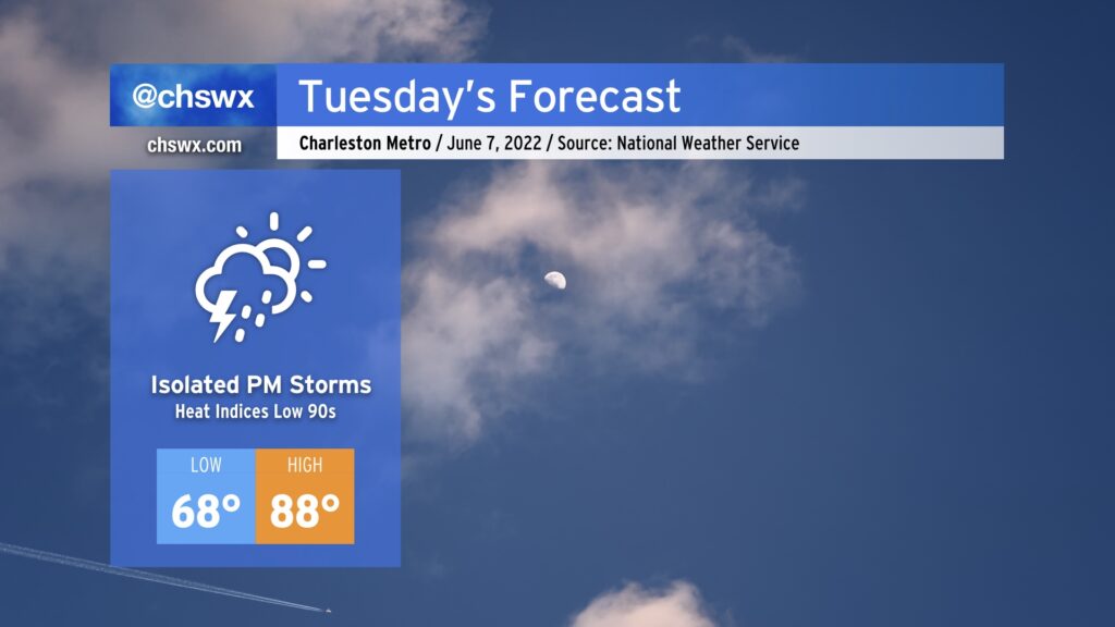
After what was a rather pleasant day today, summer warmth returns to the weather picture beginning Tuesday. Temperatures will top out in the upper 80s in the afternoon, with heat indices running in the low 90s. An isolated storm or two can’t be ruled out, but the majority of us get the day in rain-free.
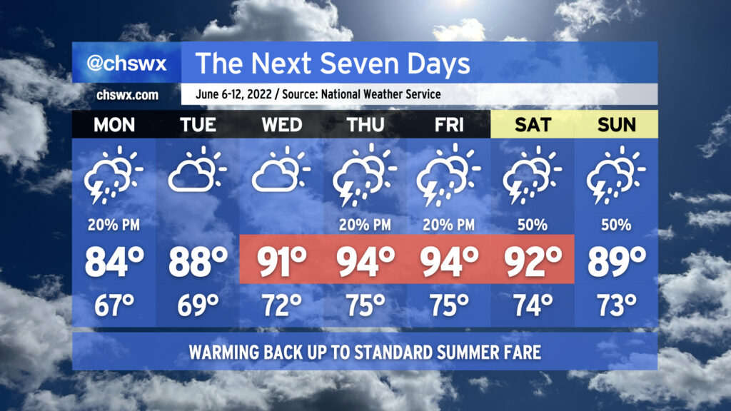
Overall, we’ve got a pretty standard June week ahead in the Lowcountry, with temperatures turning warmer as the week progresses. We’ll go from the mid-80s on Monday to the mid-90s by Thursday and Friday ahead of a cold front that will approach the area for the weekend.
We’ll have the customary summertime slight shower and thunderstorm chance most afternoons (though Tuesday and Wednesday look more likely to stay dry than not). As we head toward the weekend, though, we’ll be watching the aforementioned front and a sharpening trough aloft for an uptick in shower and thunderstorm chances perhaps as early as Friday, but more likely as we get into the weekend. As is customary in June, showers and thunderstorms will be on-and-off, primarily concentrated in the afternoon, and not a total loss of a day as a result. (And yes, it’s too soon to say just how much of an impact we’ll see on the Spoleto finale at Firefly.) Just make sure outdoor activities have backup indoor plans in case showers and thunderstorms approach. While severe weather doesn’t look terribly likely, lightning makes every thunderstorm dangerous. When thunder roars, go indoors!
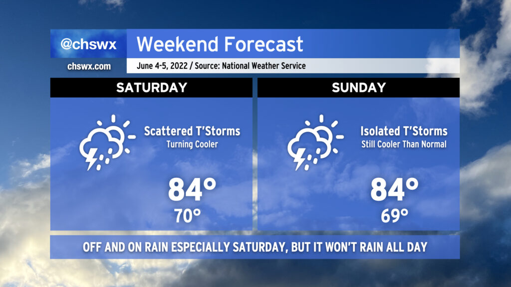
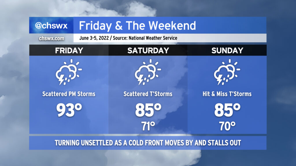
As we head into the weekend, we’ll get a break from the run of mid-90s that we’ve seen in the latter half of this abbreviated work week. This is courtesy of a cold front, which will sink southward across the area tonight bringing with it some showers and thunderstorms. Said front is expected to stall out to our southeast, and this combined with an influx of tropical moisture from what could be an eventual tropical cyclone well to the south and some energy rippling through aloft will be enough to generate periods of showers and thunderstorms for much of the day Saturday. It won’t rain all day at any one location, but be ready to move outdoor activities inside quickly in case the weather changes. Highs top out in the mid-80s on Saturday thanks to the cooler air and expected cloud cover. Sunday should be a little bit drier, though there will still be a slight chance of showers and thunderstorms. Highs once again will top out in the mid-80s, and with any luck, there will be longer breaks in the rain so you can enjoy it a bit.
We have one more fairly hot day in store before a cold front moves into the area later tonight, bringing with it some unsettled weather — perhaps a strong thunderstorm or two — before moving through and stalling out to our southeast, keeping rain chances in play for the weekend (though turning a little better by Sunday).
Today will start as the past few days have, with temperatures heading into the 90s by early afternoon. Around 2-3 PM, we should start to see showers and thunderstorms fire on the seabreeze — perhaps as close to the coast as the US-17 corridor — before gradually moving inland with time. At the same time, we’ll be watching the cold front to our north and west continue to press into the Carolinas. With the seabreeze, other colliding outflow boundaries, and the approaching front, a couple storms could turn strong to severe, particularly inland. Damaging wind gusts are the primary concern.
The convection-allowing models hint at a lull in the activity this evening before the front gets through the area, perhaps spreading some showers and a few thunderstorms into the area after midnight. Once the front gets through, we will feel somewhat cooler temperatures for the weekend courtesy of winds turning east and northeast as high pressure wedges in from the north. Winds could be a little breezy thanks to a pressure gradient between the aforementioned high pressure and what is expected to be Tropical Storm Alex as it passes well to our south. Alex could also help bring some additional moisture into the area particularly on Saturday, which will keep shower and thunderstorm chances elevated throughout the day (though the highest in the afternoon with daytime heating). By Sunday, the atmosphere dries out a little, but a few hit or miss showers and thunderstorms remain possible into the early evening.
Bottom line for your weekend: It won’t rain all day at any one particular location, but have that rain plan ready to go for any outdoor activities, particularly on Saturday when the probability of precipitation is higher. (And enjoy the cooler temperatures!)
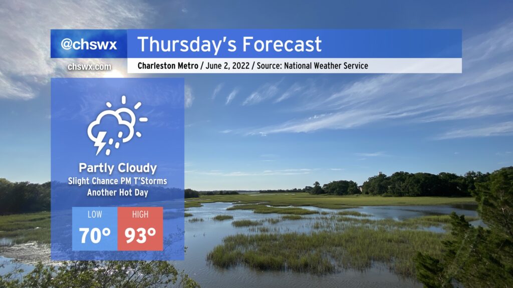
Another hot day is in store for Thursday as highs once again soar into the 90s under partly cloudy skies. Add humidity in, and heat indices could reach 96-97°. There’s a slight chance of a popup thunderstorm or two tomorrow, but the vast majority of us once again look to remain rain-free. If storms do fire, they could produce some gusty winds, heavy rain, and cloud-to-ground lightning, so be ready to move indoors if you’ve got outdoor plans tomorrow afternoon.