Jared Smith founded @chswx on Twitter in 2008 as an experiment in disseminating weather data through social media. In the ensuing decade-and-a-half, @chswx has provided live coverage of tropical cyclones, tornadoes, severe weather, and even a couple bouts of winter weather to the good people of Charleston, SC.
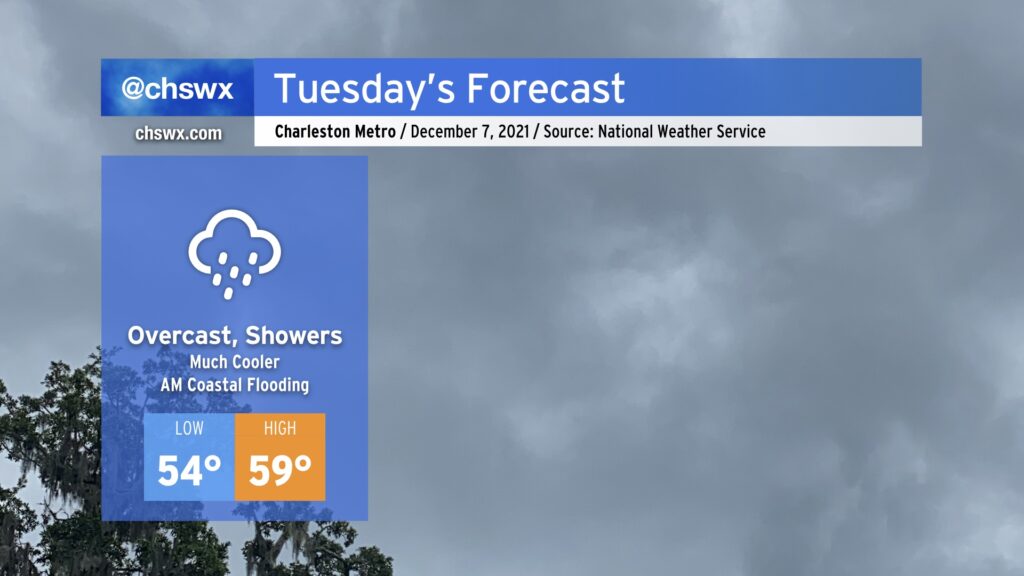
We’re turning much cooler for Tuesday as high pressure wedges into the area from the north in the wake of a cold front which will pass through overnight, perhaps bringing a few showers with it as it moves by. Southwest winds in the low levels will lift moisture over the high pressure wedge, producing ample cloud cover with occasional light showers possible throughout the day. This will act as a strong governor on temperatures, which may not break 60° in the afternoon.
We should see another round of minor coastal flooding around the 10:18 AM high tide Tuesday morning. Be ready for salt water on a few area roads, especially around Gadsden Creek (Fishburne/Hagood corridors near the Citadel and the Joe). Widespread coastal flood impacts are not expected.
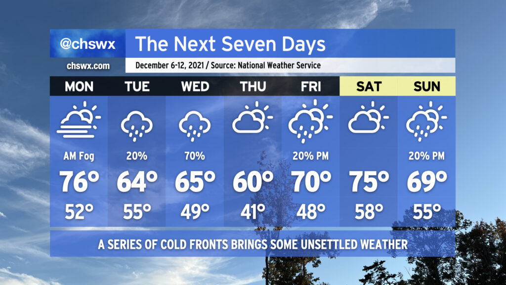
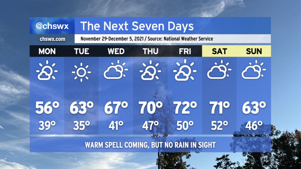
The week ahead features something we haven’t seen in a little while: legitimate rain chances across the metro area, thanks to a couple cold fronts poised to affect the area throughout the week.
Monday begins with another foggy start, with the potential for dense fog certainly in play across much of the area to start the day. Be ready to slow down and use low beams during the morning commute. Temperatures will then rise into the mid-70s despite predominant cloud cover.
Temperatures take a tumble Tuesday as a cold front backdoors into the area, allowing high pressure to wedge down from the north. A few showers can’t be ruled out as southwest winds aloft overrun the wedge, causing lift, clouds, and some precipitation. The better shot of rain is on Wednesday as some upper-level help arrives to improve forcing for ascent and helps to shove another cold front offshore. Thursday looks to be the coolest day of the set as another high pressure wedge looks to take hold, keeping partly to mostly cloudy skies in place with temperatures struggling to reach 60°. We warm back into the 70s on Friday as we head into the weekend with slight shower chances at times.
We’ll also need to continue to monitor morning high tides for the first part of the week for minor tidal flooding thanks to the recent new moon at perigee. Right now, it looks like the 9:21am high tide on Monday could top out between 7.1-7.3′, which would produce some flooding near Gadsden Creek and perhaps even into the City Market. Tuesday and Wednesday mornings could also see minor flooding episodes. Keep an ear out for Coastal Flood Advisories from the National Weather Service.
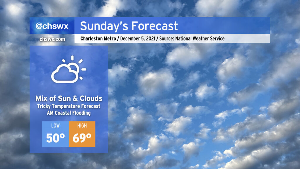
After a foggy start, the temperature forecast could be a bit tricky on Sunday as we see how entrenched a wedge of high pressure from the north can get across the area. If the wedge can build in and hold up (additional cloud cover would help), temperatures may not get out of the 60s. If the wedge comes out on the weaker side and erodes a bit, there’s a chance we may once again reach the low to mid-70s in spots. Recent model guidance has trended back warmer from earlier today, but the wedge can sometimes be stronger than what guidance will depict. The good news is that the forecast remains rain-free regardless. Just be ready to make quick wardrobe adjustments if needed.
There will once again be a risk for shallow coastal flooding around the 8:26 AM high tide. Water levels should reach 7.3-7.5′ in the harbor, perhaps on the higher end of this depending on the extent and strength of northeasterly winds. Be ready for a few road closures in downtown Charleston tomorrow morning, but widespread problems are currently not expected.
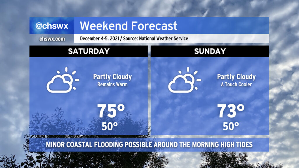
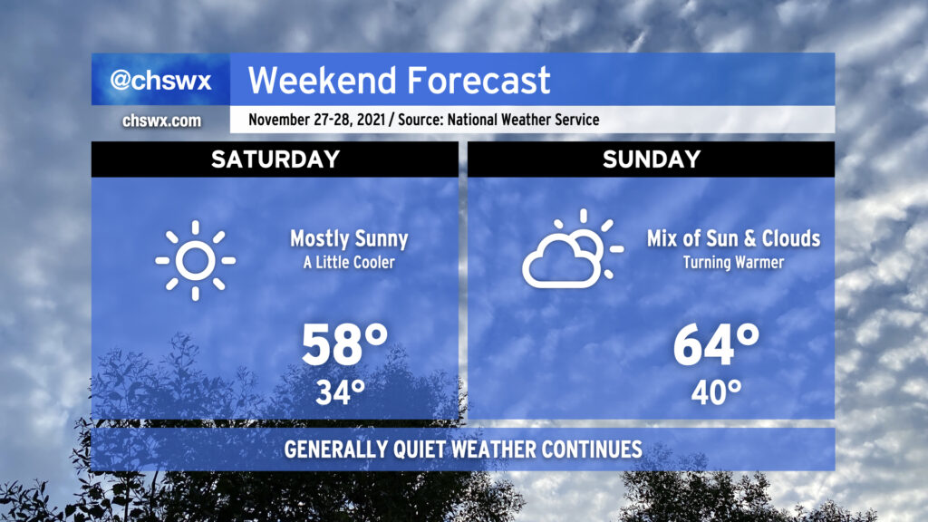
High pressure remains in control of our weather over the weekend, keeping partly cloudy skies in place and unseasonably warm temperatures in tow. We look to return to the mid-70s Saturday after starting out around 50°, weather that is more reminiscent of October than December. We keep this in place on Sunday, with highs perhaps coming in a couple degrees cooler as a cold front gets nearby (but not through the area, it looks like).
The only weather worry will be the risk for minor coastal flooding with the morning high tides on Saturday, Sunday, and possibly into Monday as the new moon at perigee brings us another round of king tides. High tide on Saturday morning arrives around 7:32am and on Sunday at 8:26am. Minor flooding can close a few roads around downtown Charleston, particularly near the Citadel and the City Market, but these disruptions should be easy to bypass. (It’ll be nothing like what we saw around this time last month, that’s for sure!) Keep an ear out for Coastal Flood Advisories from the National Weather Service and avoid roads covered in salt water as that’s nasty for your car.
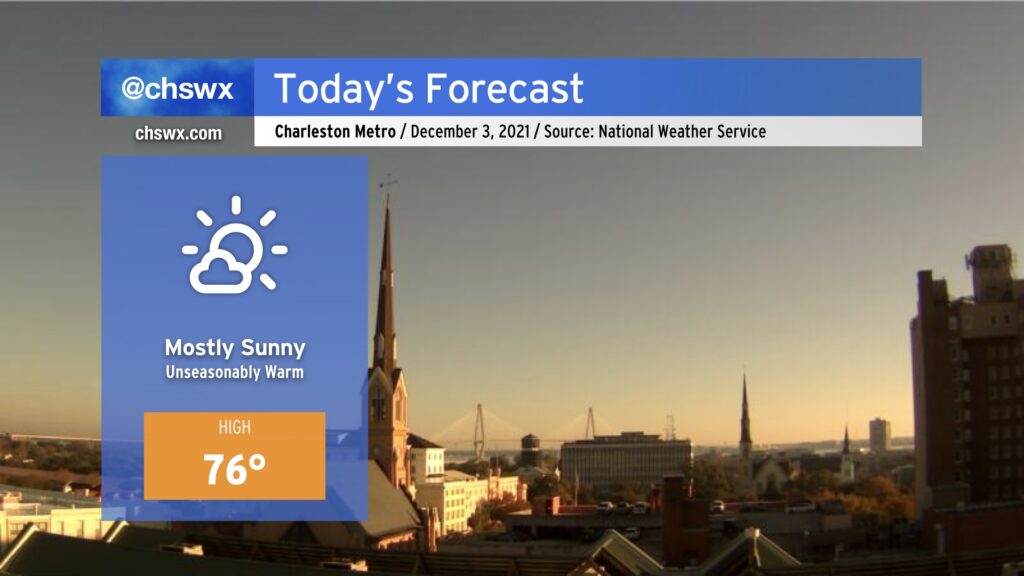
Mostly sunny skies and unseasonably warm temperatures will reign once again today as we remain under the influence of high pressure centered over the Gulf. Westerly winds with a touch of a downslope component will help temperatures warm some 8-10° above normal for early December. Warm weather fans, rejoice! Cool weather fans…I’m sorry.
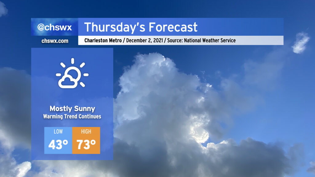
We hit 70° at the airport today for the first time since November 21, when we topped out at 75°. We’ll head north of 70° again on Thursday after starting the day in the low 40s in the metro (upper 30s further inland). Looks like we’ll top out in the low-to-mid 70s in the afternoon, with slightly cooler air at the immediate coast keeping temperatures in the upper 60s at the beaches. All in all, a fairly stellar December day (for our warm weather fans, anyway).
The 70s could continue all the way through next Monday before another frontal passage knocks temperatures back into the low 60s on Tuesday. Overall, the Climate Prediction Center outlook favors warmer-than-normal temperatures over the next couple weeks after what was a rather chilly November, tying 1940 for ninth-coolest November on record at the airport climate site with an average temperature of 54.1°. (Records began at the airport climate site in March of 1937.)
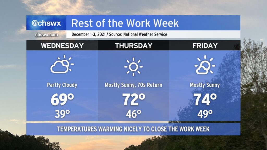
Meteorological winter begins tomorrow, running from December 1 through February 28, 2022. It sure won’t feel like it, though: temperatures will warm to near 70° on Wednesday, and then peek into the low to mid-70s on Thursday and Friday. We’ll have some cloud cover associated with a weak disturbance aloft Wednesday, but other than that, expect quite a bit of sunshine over the next few days.
The only weather concern looks to be a small risk for minor coastal flooding beginning with Friday morning’s high tide as we head toward the new moon phase. So far, the NWS forecast has that tide peaking just shy of 7’, which is the minor coastal flooding criteria. Peeking a little further down the road, guidance indicates that Saturday morning’s high tide may scrape that 7’ threshold as well. So far, though, it certainly does not appear to be a repeat of the last new moon, which brought us top-15 tides during the first week of November.
Finally, we bid adieu to the 2021 hurricane season, which was another extremely busy season in terms of named storms (21). For the second consecutive year, the primary storm name list was exhausted — but we did not have to crack open the supplemental list, at least. Once again, our luck has held here — aside from the quickly-developing Tropical Storm Danny and the nocturnal tornado outbreak associated with Tropical Storm Elsa, it was another rather quiet season for the Lowcountry, and for that I am grateful.
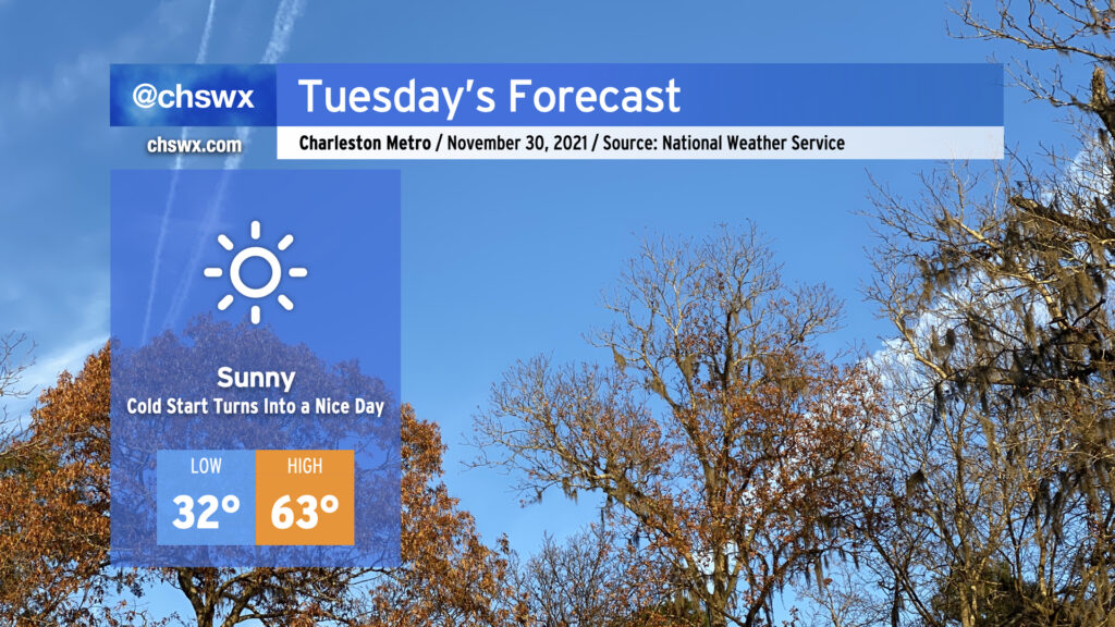
A freeze is expected overnight into Tuesday morning across much of the Lowcountry away from the immediate coast and near bodies of water. Make sure sensitive plants are covered and your pets are inside and warm!
Once we clear the chilly start, it’s going to turn out to be a really nice day across the area as highs head into the low 60s under brilliant, unfettered sunshine — a rare no weather worries day! Quiet weather continues for the next several days as a warming trend commences heading into the end of the week, in which the 70s will make a return.
The cherry on top? Tomorrow’s the last day of hurricane season — something we all can celebrate.
Below-normal temperatures and mostly sunny skies will continue through Tuesday to close out November, meteorological fall, and hurricane season as a weak front gets through overnight to reinforce the cooler airmass in place. Changes are coming, though — as the calendar turns to December and the beginning of meteorological winter, we’re gonna get warmer. The warming trend begins Wednesday, and we’ll look for temperatures in the low 70s for a spell Thursday-Saturday with generally partly cloudy to mostly sunny skies before another front gets through Sunday, sending temperatures a few degrees back below normal.
One thing that’s not forecasted? Rain, at least this week. Persistent dry air continues to keep any sort of rain to a bare minimum across the area with tonight’s frontal passage and will likely at least hamper rainfall development over land with Sunday’s passage, too. Peeking ahead in time, models suggest that the second week of December could see a little bit more in the way of precipitation, but we’ll need to see if that signal holds. For now, though, a good chunk of the Tri-County remains in abnormally dry conditions, with some of the northern fringes creeping into moderate drought. I expect this drought area to expand with Thursday’s Drought Monitor update.
For now, though, we will continue to savor the quiet weather. Have a great week ahead, and Happy Hanukkah to all of you who are celebrating!
We’ve got another chilly night ahead; temperatures could scrape freezing at a few spots by Saturday morning, so be sure you’ve got sensitive plants still protected and your pets have a warm place to be overnight.
Saturday will run a little cooler than today did in the wake of a cold front that came through earlier today. After starting the day around freezing (with wind chills making it feel about 3-5° colder), highs will top out in the upper 50s despite mostly sunny skies. Winds look to be generally light throughout the day with a shift in direction to the southwest late.
Sunday will feature more clouds but will also be warmer thanks to westerly winds ahead of another weak cold front poised to come through early Monday morning. Temperatures will rebound to the mid-60s in the afternoon after starting around 40°, making for a seasonably comfortable late November day in the Lowcountry.