Jared Smith founded @chswx on Twitter in 2008 as an experiment in disseminating weather data through social media. In the ensuing decade-and-a-half, @chswx has provided live coverage of tropical cyclones, tornadoes, severe weather, and even a couple bouts of winter weather to the good people of Charleston, SC.
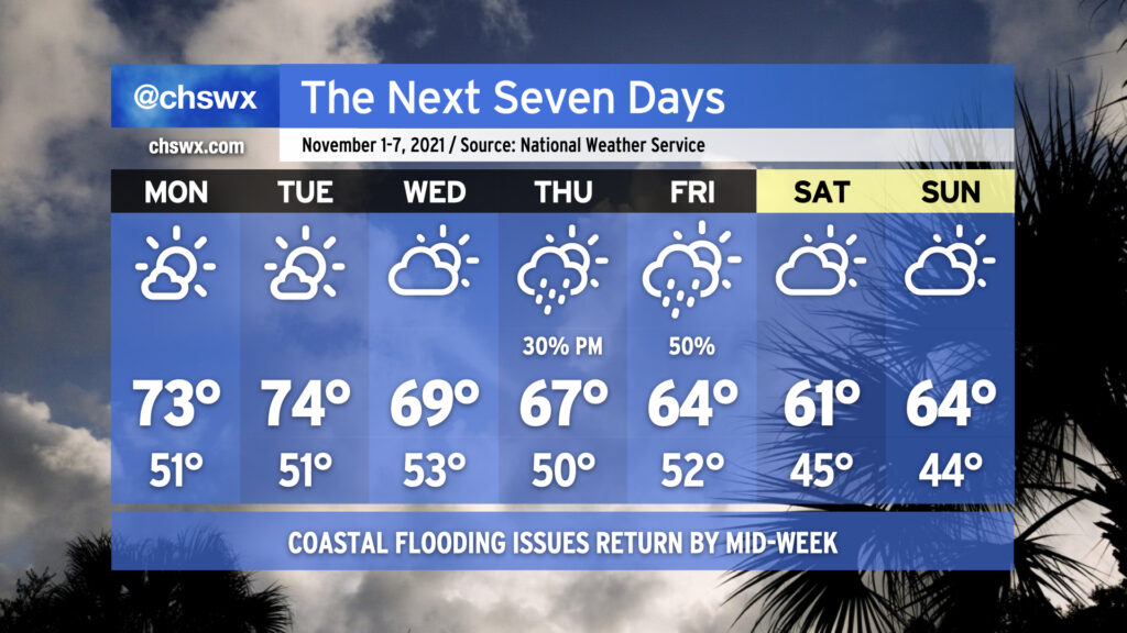
If the random few shots of cool weather in the past few weeks haven’t gotten you to extract your fall attire just yet, you’re going to want to get on that by the end of this week as prolonged below-normal temperatures are in the cards. Indeed, the air is going to take on quite a November feel (though one more characteristic of late November than the beginning) by the weekend. While you’re grabbing the sweaters, though, you might want to reach for the waders, as well, with moderate to major salt water flooding possible around times of high tide by the end of the week.
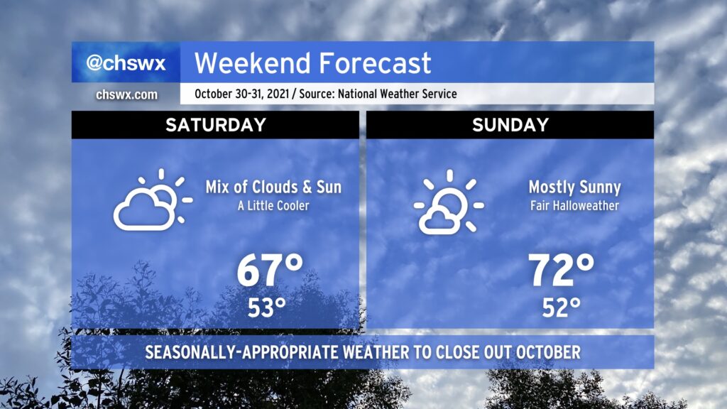
The potent upper low which helped drive through a front with heavy rain and gusty winds yesterday remains over the Southeast through this weekend, keeping temperatures on the cool side and cloud cover a little elevated, particularly on Saturday. We’re very likely not to get out of the upper 60s on Saturday given the mix of clouds and sun that’s expected. (You might want a sweater, at least for a bit!)
Sunday will run a touch warmer and a little sunnier, too, making for a rather pleasant Halloween free of weather-related frights. Nice weather on a warming trend looks to continue for the first few days of November, too. Enjoy your weekend!
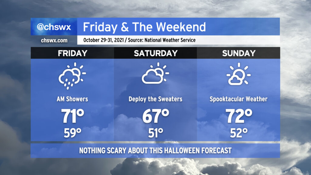
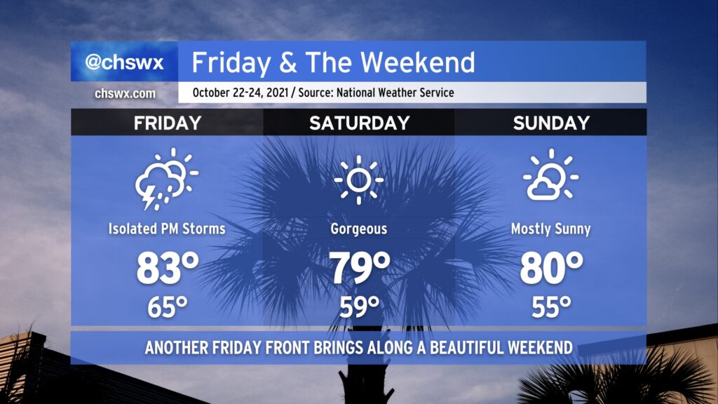
After some lingering showers clear the area Friday morning, we will head into the weekend with quite seasonable weather to close out October. Friday looks to be another breezy day across the area as low pressure in the Tennessee Valley lumbers northeastward. A shower or two can’t be totally ruled out in spots on Friday afternoon, but the chances are relatively small. Same for Saturday, as a mix of sun and clouds keeps highs in the mid-to-upper 60s across the area with a stray shower or two possible (but unlikely). Expect more sun for Halloween as high pressure begins to reassert itself a little bit and drier air takes hold over the area. Trick-or-treating will be in fine shape (weather-wise, at least). Be safe and enjoy!
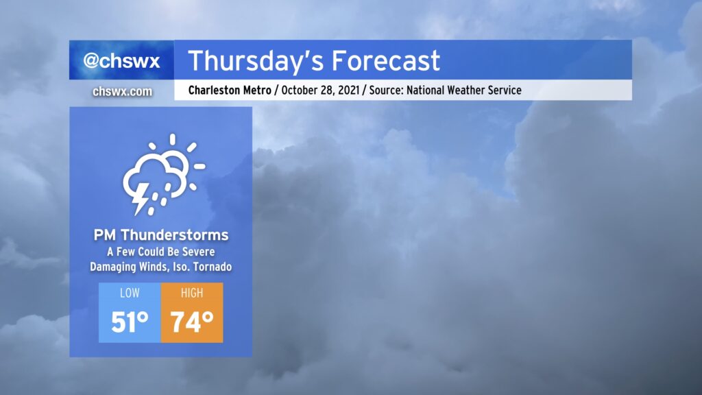
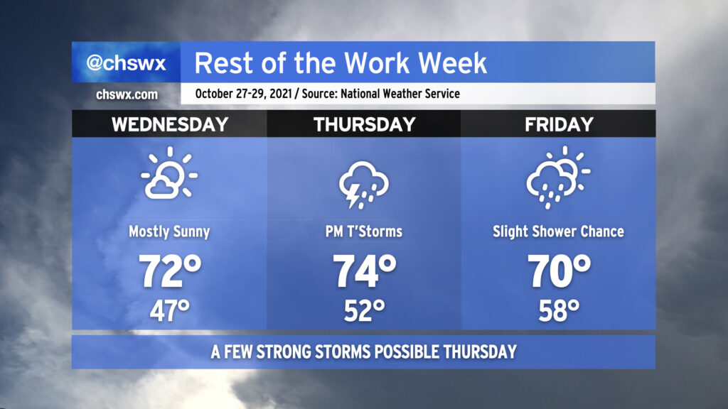
We’ll start Thursday much as we started today — a mix of sun and cloud cover with a bit of a chill in the air as lows bottom out in the low 50s. We look to end it with widespread rain with embedded thunderstorms, a few of which could be strong to severe, as a potent upper low and associated cold front approach the Lowcountry.
The severe weather threat on Thursday is certainly not a slam-dunk, but there are some concerning signals. First, there’s going to be plenty of wind energy available. A low-level jet of 55-65 MPH winds around 3,500 up looks to traverse the area in the afternoon and evening hours. This will help promote gusty winds throughout the day, even ahead of thunderstorms. Second, winds are veering with height, with southeasterly surface winds turning southerly and then southwesterly as you go up. This wind shear helps sustain thunderstorm updrafts and also can induce spin within stronger storms. Third, there is the potential for instability to spread into the area as a warm front passes by in the evening. However, instability is the biggest question mark given cloud cover and rain ahead of the storms, which often helps to tamp down on this “storm fuel” and, as a result, decreases the severe weather risk.
Ultimately, we will need to keep an eye on how things evolve tomorrow. If that instability does materialize as some of the guidance suggests it will, a few thunderstorms will be able to pull down some strong, potentially damaging winds. Given the spin in the atmosphere, a tornado or two is not out of the cards, either. Our best risk for severe weather appears timed between 4 and 10 PM, according to NWS, with the latter end of the timeline looking the most likely for SC. Stay weather-aware tomorrow and make sure you have multiple, redundant weather warning sources.
Wednesday will be another pleasant weather day. We’re going to get off to a chilly start with lows in the 40s across the area away from the locally warmer coastline. Temperatures will top out in the low 70s, and it’ll feel good in the sun.
As we head into Thursday afternoon and evening, we will want to watch the risk for heavy rain with the potential for a few strong to severe thunderstorms. Damaging wind gusts will be the primary concern, but the forecast wind profiles are such that a tornado cannot be totally ruled out. We’ll need to see how much instability can develop — the less instability, the better. Stay tuned to forecast updates.
The upper-level low that will help to drive Thursday’s severe threat will linger into Friday, keeping clouds and perhaps a few showers in the forecast. Temperatures won’t top out much higher than 70° on Friday afternoon.
Good news, though: The weekend looks good with sweater weather on Saturday, and Halloween is very much game on with picture-perfect weather to close out October.
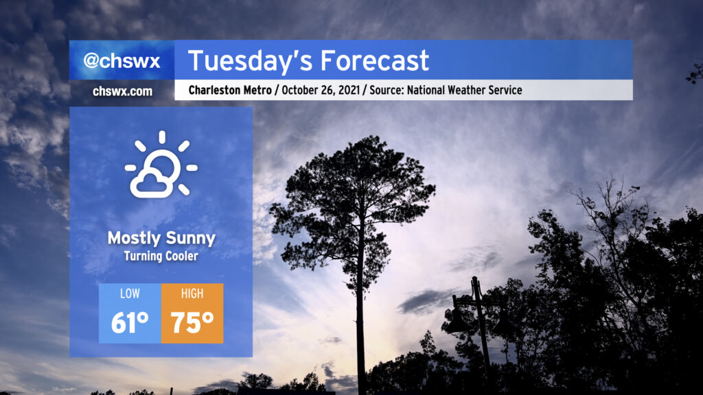
A cold front will come through early Tuesday, and with it will be a shot of cooler and drier air that will make for a pleasant day across the Lowcountry. We’ll start the day in the low 60s with highs rising to the mid-70s under mostly sunny skies. Overall, a really good day to get lunch outside if you can.
We’ll see a similar weather day on Wednesday with a cooler start (40s look possible in many spots). Thursday continues to look unsettled as a potent storm system approaches the area. Rain, heavy at times, will be the main concern, though a couple stronger storms are possible as well. We keep showers around on Friday as a lumbering upper low swings through the area before gradual clearing into the weekend.
We’ll see a little more of an unsettled pattern going into this week with plenty of temperature peaks and valleys to close October. Monday looks to begin with rain overspreading the area in response to an area of low pressure developing offshore, making for a wet morning commute with some rumbles of thunder possible especially near the coast. Overall rain amounts shouldn’t be terribly heavy, but watch for some slick roads nonetheless as much of the area hasn’t received rain for the better part of two weeks.
A cold front swings through late Monday, bringing with it a slight chance for showers and thunderstorms in the afternoon and evening hours. Thereafter, we will see a nice little cooldown for Tuesday and Wednesday with quiet weather expected. Lows Wednesday morning look to dip into the lower 50s.
We’ll be dealing with a pretty potent storm system heading into Thursday and Friday as a strong upper low digs southward toward the Gulf Coast and brings a cold front with it. Showers and thunderstorms — with a couple stronger storms not out of the question — look to come into the area primarily Thursday afternoon through Friday morning. Temperatures on Thursday peak in the mid-70s and the low 70s on Friday as clouds and maybe a shower or two persist through the rest of the day.
After the front passes through, we’ll get another shot of autumn-appropriate air for the weekend. Lows will flirt with 50° and lower with highs not even reaching 70° on Saturday under partly cloudy skies. Seasonable weather continues for Sunday — solid weather for costumed candy acquisition activities.
We’ve got more excellent weather on the way for this weekend, but first, we deal with a weak cold front on Friday. A few showers and storms could pop off in the afternoon ahead of said front before it swings through, but the vast majority of us look to stay dry. Expect warmer-than-normal temperatures, especially in the morning where we get started in the mid-60s away from the warmer coast and top out in the low-to-mid-80s in the afternoon.
Once the front is through, another area of dry high pressure works into the area. Saturday looks extremely good, starting out in the mid-to-upper 50s with highs topping out shy of 80°. After another cool start in the mid-50s, Sunday will warm to around 80-81° under mostly sunny skies. Enjoy!
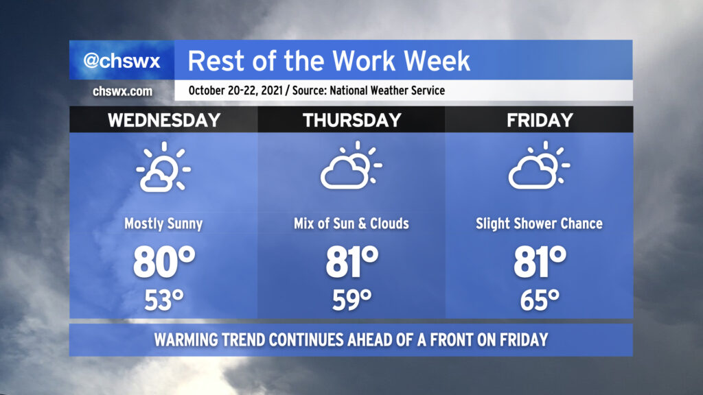
A warming trend will continue for the rest of the work week ahead of a cold front swinging through on Friday. Highs look to return to the 80s for Wednesday and beyond, though just barely. Lows will be creeping up more noticeably; we’ll wake up to low 50s on Wednesday, near 60° on Thursday, and in the mid-60s on Friday.
We stay rain-free through Thursday, and it’s probable that you’ll stay dry on Friday, too, with just a little moisture available for the front to squeeze out a few isolated showers in the afternoon. Overall, our weather pattern remains relatively quiet heading into the weekend, but there’s no sign of another good shot of cold air just yet as the temperature trend continues to favor above-normal temperatures heading into next week. (It is nice to dry out a bit, though!)
Expect a relatively tame week of weather as a series of high pressure systems transit through the area. We’ll get Monday off to the chilliest start since we bottomed out at 49° on May 15 as widespread 40s are expected under clear skies. Much like today, temperatures will rise back into the low 70s for the afternoon, making for a rather delightful day (weather-wise, at least.)
A warming trend commences Tuesday into midweek as high pressure moves over the area and eventually offshore, allowing temperatures to return to the 80s by Thursday. A dearth of moisture, though, will keep these above-normal temperatures feeling quite alright. A cold front comes through sometime late Friday into Saturday, allowing another area of cooler high pressure to build back in.
It’s a rare week of little to no weather worries: tides remain in check, the tropics are quiet, and we look to stay mostly rain free (unless Friday’s front can squeeze out a shower or two). We’ll have a good mix of cooler and warmer temperatures — really, a little something for everyone. Enjoy it!