Jared Smith founded @chswx on Twitter in 2008 as an experiment in disseminating weather data through social media. In the ensuing decade-and-a-half, @chswx has provided live coverage of tropical cyclones, tornadoes, severe weather, and even a couple bouts of winter weather to the good people of Charleston, SC.
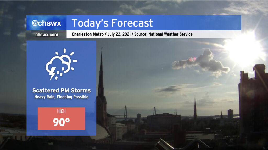
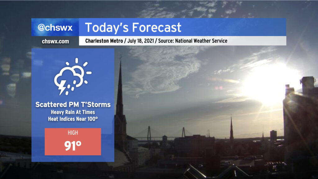
We start this Thursday with temperatures already approaching 80° as of 8am. Highs around 90° look to be common before showers and thunderstorms erupt this afternoon.
Today’s setup could portend a flooding event in downtown Charleston this afternoon and evening. Westerly winds look to pin the seabreeze closer to the coast, and with a front advancing from the north, there will be numerous focal points for showers and thunderstorms to develop. Atmospheric moisture is readily available, with precipitable water values running over 2″ once again today (anything 2″ or over generally requires more scrutiny for flooding). Finally, we are in a king tide period, and this morning’s thinking from NWS on tonight’s high tide is that it will fall just short of the 7′ level at which sunny-day salt water flooding typically begins. (It may yet be high enough, though, to begin to produce some flooding on Fishburne and Hagood.)
Guidance suggests that showers and thunderstorms generally should start to form between 1-3 PM. Storm motions will approach the coastline today, and with a seabreeze trying to push the opposite direction, this certainly invites concern about heavy rainfall stalling out for a period of time. The high-resolution model ensemble this morning once again paints a 30% chance of 3″ of rain in 3 hours across the metro area this evening, further lending credence to this concern. While this isn’t a slam dunk, it’s important to keep an eye on the weather today as impacts to the evening commute are certainly in the cards. More on this later today — stay tuned.
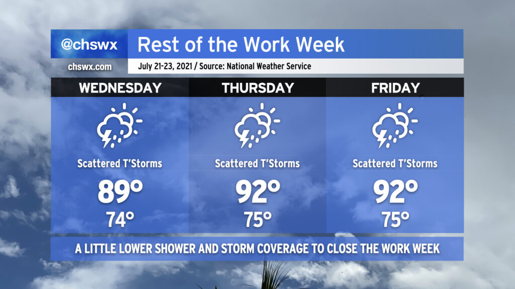
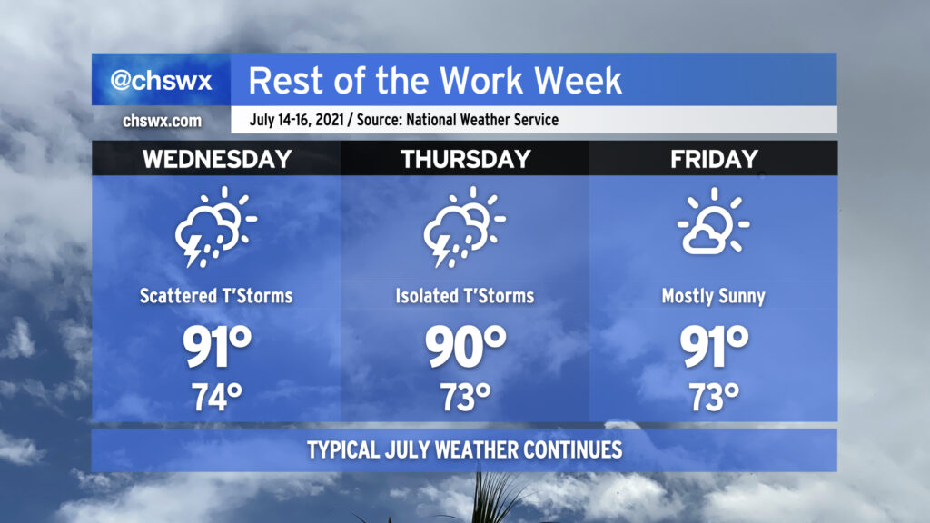
We’ll get back into a warming trend for the rest of the work week as the mid-level trough that’s been keeping us quite unsettled yields to a little more ridging over the next few days. This will, in turn, help suppress the more widespread shower and thunderstorm development we’ve seen to start the week. Expect scattered showers and thunderstorms primarily each afternoon as daytime heating and the seabreeze kick in. Heavy rain will be possible within the strongest storms, particularly on Wednesday as deep tropical moisture remains in place. We’ll see this deeper moisture shunted a little further south getting into Thursday and Friday, cutting the heavy rain threat a little bit more, but it’s summer — an isolated downpour or two just cannot be ruled out.
As mentioned earlier, temperatures are going to warm up, and we’ll be back into the low 90s by Thursday. Mix in some humidity and it’s going to feel like the low 100s, so make sure you’re getting enough water and shade if you’re outdoors in the peak of the afternoon.
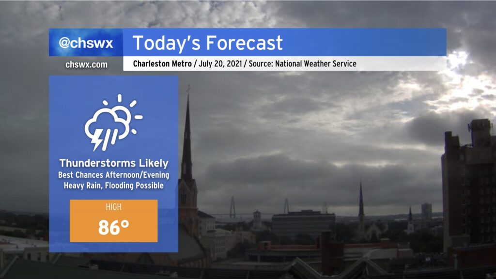
We look to have another wet day ahead, with some showers already popping up west of the Ashley as I write this. The best chance for showers and thunderstorms will again be later this afternoon into this evening. There will once again be a chance for localized heavy rain, with a 30% probability of 3” of rain in 3 hours once again being indicated by the high-resolution ensemble data. Yesterday this bore out in the 17-A corridor headed into College Park, with floodwater on the ground for a few hours after the main rain event. Thus, we are going to need to watch radar trends carefully, noting that high tide will be coming up at 5:39 PM.
Clouds and rain will keep temperatures a few degrees below normal, with highs in the mid-80s expected across the area. A few peeks of sun aren’t out of the question, allowing temperatures in a few spots to perhaps jump quickly. Humidity will still factor in, though, and it’ll feel closer to 94-95° in the afternoon.
Try to stay dry and weather-aware once again today!
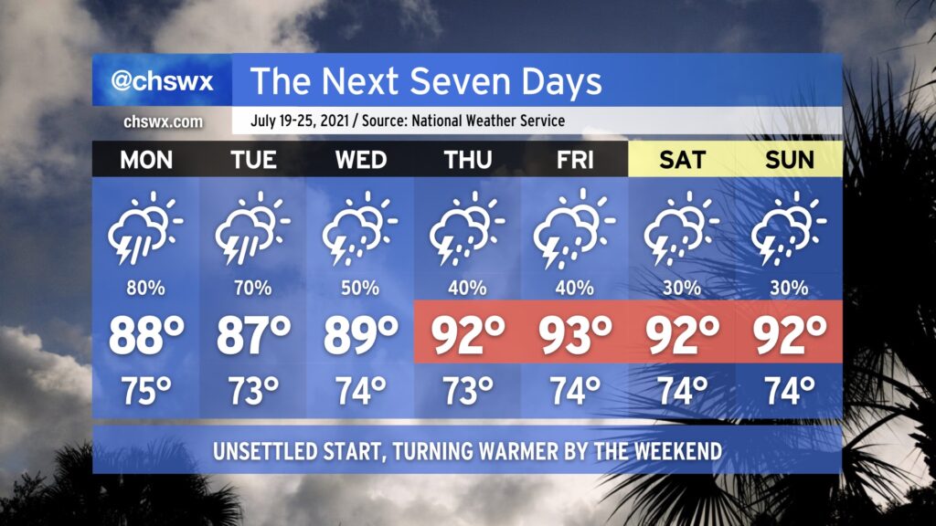
We’ll be getting this work week off to a wet start. Showers and thunderstorms will be commonplace as upper level energy combines with a stalling surface front and copious amounts of atmospheric moisture especially Monday afternoon into Tuesday. Heavy rain is certainly a concern, and we will want to monitor the risk for sporadic freshwater flooding episodes closely. Clouds and rain look to keep highs down into the mid-to-upper 80s, a few degrees below normal for this point in July.
As we get into Wednesday, we begin to see this soggier pattern break down and a more standard summertime regime returning to the area. We are back in the 90s by Thursday with more scattered coverage of showers and thunderstorms primarily in the afternoons heading into the weekend.
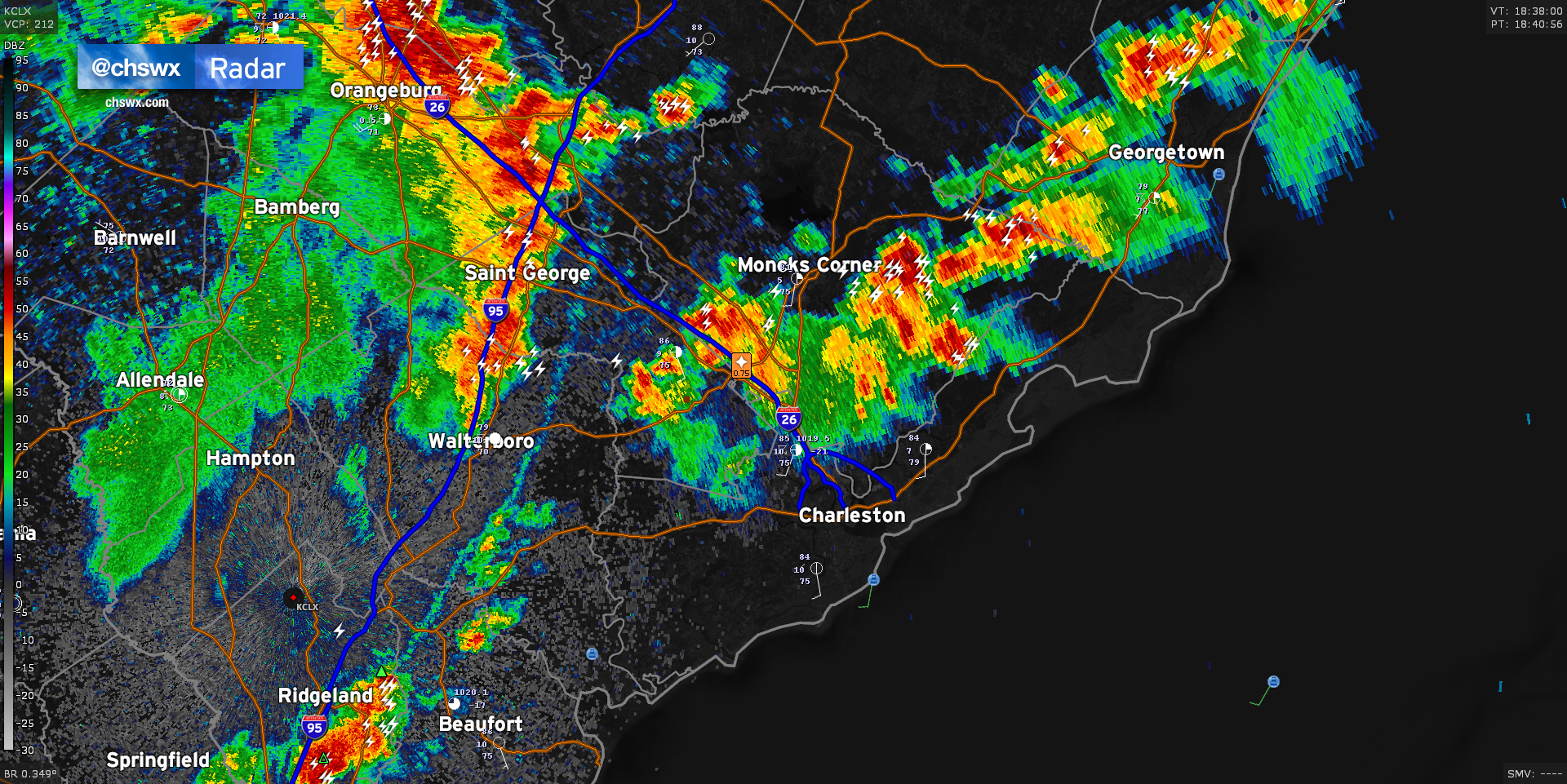
Radar is active this afternoon with two distinct areas of thunderstorms that look to merge over the next hour, potentially bringing storms further eastward toward the coast this evening. The first area is situated across the inland-moving seabreeze, which roughly sets from Ridgeville through Moncks Corner to Jamestown. Along this line, we’ve seen hail to the size of pennies reported in Summerville with a risk of strong wind gusts approaching 55 MPH. The second area to watch is coming in from the west, aided by a mid-level impulse and riding a fairly potent outflow boundary. This outflow boundary looks to collide with the seabreeze over the next hour, sparking up additional thunderstorms especially to the southwest of the area and across the Santee Cooper lakes. Damaging wind gusts and large hail can’t be ruled out as the two boundaries collide. The resulting thunderstorm complex should continue to head eastward as the afternoon goes on, with thunderstorms likely reaching the coast by early evening.
Remember: When thunder roars, go indoors! Every thunderstorm is dangerous due to the lightning it produces.
We’re starting today with partly cloudy skies and muggy temperatures in the mid-70s. This will give way to 90s ahead of the seabreeze this afternoon; heat indices will push 100° with low 70s surface dewpoints in place. Showers and thunderstorms will fire on the seabreeze possibly as soon as noon-1pm, which could portend some rainfall or lightning concerns at area beaches early this afternoon. The seabreeze will then make its usual daily inland trek, bringing the risk for showers and thunderstorms more inland with time. This will happen as a mid-level disturbance moves into the area, which will enhance the coverage of showers and thunderstorms today into tonight. Some areas of heavy rain are certainly possible, with the high-resolution model ensemble painting a 10% chance of 3″ of rain in 3 hours across the entire coastal plain. This could lead to isolated bouts of flooding, so we’ll want to watch this closely throughout the day.
Rain chances will continue overnight into Monday, with the risk for heavy rain continuing throughout the day Monday. More on that later today as we get the daytime guidance package in.
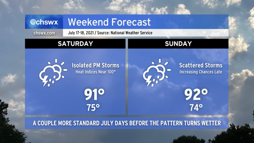
We’ve got more of the same July weather in store for the weekend. Heat and humidity will continue across the Lowcountry as highs top out in the low 90s each afternoon. Heat indices will approach 100° with the humidity in place, so be sure to watch your exertion during the peak of the afternoon heat.
Much like the last few days, we’ll see isolated showers and thunderstorms initiate on the seabreeze and move inland on Saturday. The pattern begins to change up on Sunday as a cold front begins to approach the area. Rain chances increase later in the day, and if the convection-allowing models are correct, it could be a somewhat stormy Sunday night. We’ll want to watch that trend, but overall, I hope you can enjoy a good weekend for summer activities across the area.
Atlantic high pressure and ridging aloft remains in control of our weather for a few more days before a pattern change greets us with increased chances for showers and thunderstorms for the new work week.
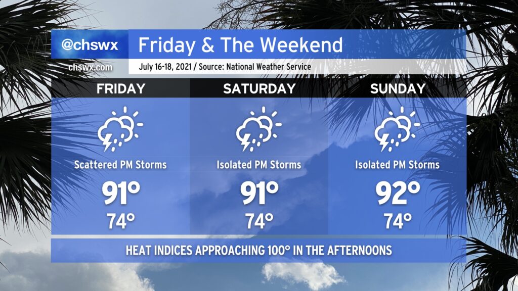
Temperatures through the weekend will top out in the low 90s each afternoon, but low-to-mid-70s surface dewpoints will make it feel a little closer to 100°. We’ll see the standard mid-July isolated to scattered coverage of showers and thunderstorms ahead of the inland-advancing seabreeze each afternoon. You can never totally rule out a strong wind gust or two to cause problems with any summertime thunderstorm, but the risk for severe weather looks quite low. This setup should yield a few good, if not hot, beach days — pretty much exactly what we should expect this time of year.
We’re in full-blown Command-C/Command-V mode here at @chswx HQ this week, as one would typically expect in a Charleston summer: Highs in the low 90s with isolated afternoon thunderstorms expected. This forecast is right on the dot with mid-July climatology, and there’s really not too much else to write home about.
If you’re headed to the beaches or out on the water this morning, there is the risk of a waterspout underneath any tall cumulus towers, and there will be a persistent rip current risk all day. These are the only caveats — mind these and you’ll be in good shape.
The work week rolls on with pretty standard July weather as we remain under the influence of Atlantic high pressure. We’ll stay warm and muggy with lows in the low to mid-70s away from the coastal communities (where lows likely won’t dip below 80°). Highs each afternoon will continue to top out around 90-91° — right around where we should be for this time of year. Rain chances come down a touch on Friday, with mostly sunny skies currently expected.
Overall, brief heavy rain will be possible within any thunderstorms, though storms today did show a propensity to train a bit, with 2″ of rain recorded at a gauge in Mt. Pleasant within a persistent round of thunderstorms earlier today. The strongest storms could produce sporadic wind damage, but widespread severe weather is not in the forecast by any stretch.
Rain chances stay around normal for July heading into the weekend before ramping up a bit as we get into next week.