Jared Smith founded @chswx on Twitter in 2008 as an experiment in disseminating weather data through social media. In the ensuing decade-and-a-half, @chswx has provided live coverage of tropical cyclones, tornadoes, severe weather, and even a couple bouts of winter weather to the good people of Charleston, SC.
After a couple days in a classic summertime Bermuda High setup, we’ll see that high continue to retrograde eastward, giving way to a cold front sinking south from the Ohio Valley. Said front will run into an incredibly juicy airmass courtesy of a robust moisture tap from the Gulf, and help to ignite numerous showers and thunderstorms in the afternoon. This will have the effect of holding temperatures down into the mid-80s.
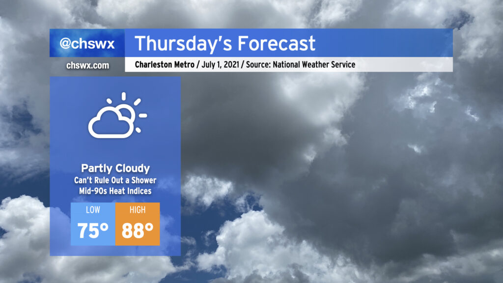
We’ve got a warm Thursday in store ahead of a cold front that will make for an unsettled Friday. Temperatures will run in the upper 80s away from the locally cooler coastline, and the humidity will make it feel well into the mid-90s. There will be a slight chance of showers and storms around midday as the seabreeze pushes inland, but that’s about it.
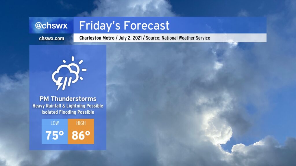
Friday will be a much different story as showers and thunderstorms become pervasive across the area ahead of a stalling cold front. This activity looks to continue into Saturday, but storm chances diminish significantly as we get into the Fourth. There’s still uncertainty here around the positioning of the front and the ultimate sensible weather outcome for the Charleston Metro Area, so I continue to encourage y’all to keep an eye on forecast updates as we head into the long holiday weekend.
The rest of the work week will feature generally isolated to scattered shower and thunderstorm coverage ahead of a cold front that will stall in the area for Friday into Saturday, bringing greater coverage of unsettled weather (and possibly a low risk of severe weather on Friday). Thereafter, said front introduces a good bit of uncertainty into the forecast.
A Bermuda high will stay in force for Wednesday into Thursday. This will generally keep onshore flow in place, allowing occasional showers and storms to stream into the area from the Atlantic particularly in the morning hours before the seabreeze focuses additional showers and storms inland during the afternoon. Reasonably good atmospheric moisture is in place, allowing a few showers or storms to perhaps generate some locally heavy rainfall, especially where outflow boundaries collide. Temperatures will generally run in the upper 80s away from the coast.
As we get into Friday, a cold front will approach from the northwest in association with a trough of low pressure aloft. This will focus more numerous showers and thunderstorms particularly as we get into the evening. Model soundings suggest some wind shear sufficient for organizing a strong to severe storm or two, so we’ll want to keep an eye on these details as they evolve. Additionally, the Gulf will be open for business with the trough helping to draw more moisture into the area (precipitable water values exceeding 2″ for the geeks out there), so areas of heavy rainfall will certainly be possible. Ahead of the front, temperatures will still flirt with 90° before showers and storms increase in coverage.
Forecast becomes more uncertain heading into the Fourth
The aforementioned cold front will stall out somewhere nearby on Saturday, and this is where a fair bit of forecast uncertainty begins to come into play. Depending on where the front sets up, we could have a warm and fairly dry Fourth, or we might keep some more humidity, showers, and thunderstorms in the forecast. Today’s global model runs were trending a little drier, but one should never put much faith in a stalling cold front in our neck of the woods in July. My advice right now: Stay tuned to forecast updates as the details flesh out a little more.
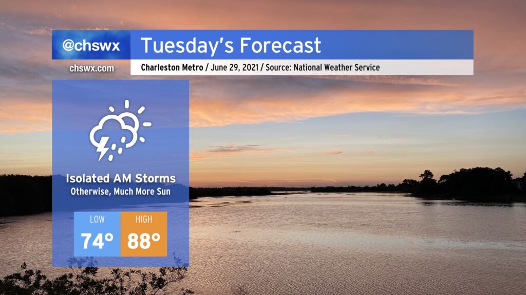
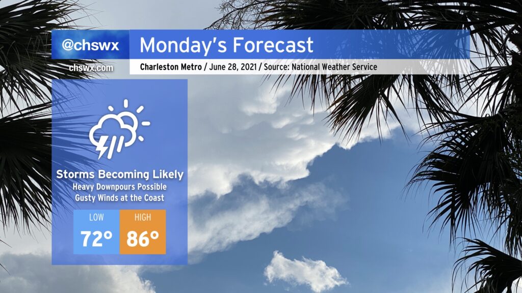
All tropical storm warnings have been discontinued as Danny moves away and weakens, and so we can now look forward to a calmer and more sunny Tuesday. We could see an isolated shower or storm come in off the Atlantic in the morning, but other than that, we should see a good bit of sunshine and warmer temperatures. Highs will top out in the upper 80s, still a few degrees below normal for late June. Rain chances head up as the week goes on, and it’s conceivable that this could end up being the driest day of the week, so try to take advantage where you can.
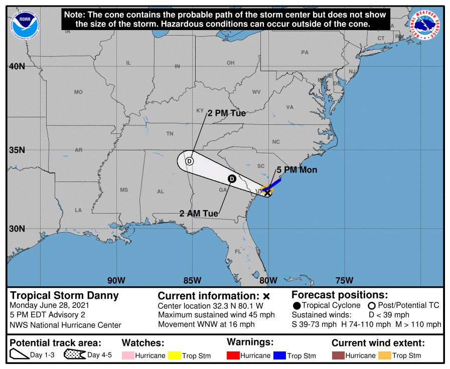
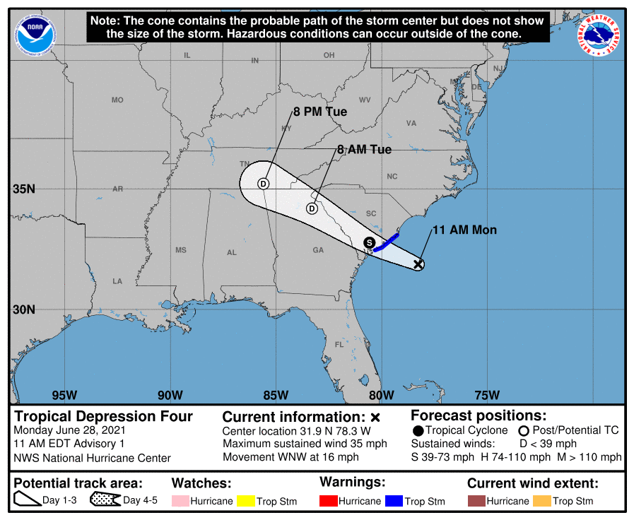
Tropical Storm Danny, which was named in a tropical cyclone update a little after 3PM after radar and recon data indicated it had strengthened, is on course to make landfall somewhere between Hilton Head and Edisto over the next couple hours.
At 5PM, it had maximum sustained winds of 45 MPH — a little up from the previous advisory. It’s still moving WNW at 16 MPH, and the NHC center fix had it 35 miles east of Beaufort and 35 miles SSW of Charleston. A tropical storm warning remains in effect for the Charleston County coastline, where gusts to tropical storm force remain possible through this evening.
On and off rain squalls have been pelting much of the Charleston area over the past few hours, with winds consistently gusting 20-30 MPH at the airport. It is worth noting, though, that with much of the heavy thunderstorm activity remaining displaced well to the west of the center, rainfall estimates have been rather tame across much of the area. The main exception is a small swath from Kiawah to Edisto, which received upwards of 1.5″ of rain after a heavy squall came through then. There have been no reports of flooding in the Charleston metro area, and so far only one report of a downed tree.
Model data and radar trends indicate that we are through the worst of it here in Charleston. The eastern semicircle of the storm is much drier, owing to the persistent wind shear that has been blowing the thunderstorms out to the west. Scattered showers continue across inland locations, but we are seeing a marked decrease in rainfall rates and coverage over the last couple hours. Still, tropical storm-force gusts will be possible especially from Charleston Harbor southward to Folly, Kiawah, Seabrook, and Edisto Islands through tonight, so we cannot totally rule out isolated power outages or additional downed trees.
The National Hurricane Center has classified Tropical Depression Four about 110 miles east-southeast of Charleston. It is moving west-northwest at 16 MPH. The forecast is for the storm to briefly strengthen to Tropical Storm Danny before the center makes landfall — currently pegged to roughly around Kiawah Island — this evening.
As for the going forecast, this doesn’t really change much. Gusty winds and periods of heavy rainfall remain the primary concerns especially near the coast. A power outage or two is not out of the question, but the thinking from earlier holds: this is going to be a lousy beach day with windy and rainy conditions.
High tide is coming up at 11:45 AM. Radar trends do suggest some rain could be in the area around that time, but the heaviest rain has so far shown itself to remain south of us. Indeed, the sheared nature of the storm has much of its thunderstorm activity well to the west of the circulation. However, given the more northward motion than models had previously indicated, the risk for some heavier rain increases slightly in the metro area. We’ll want to continue to watch this for the next few hours.
Next intermediate advisory from NHC with a position update comes at 2PM, with the next full track and advisory package at 5.
Get ready for periods of showers and thunderstorms tomorrow with heavy rain and gusty winds at the coast as a tropical disturbance of some kind comes ashore south of the Charleston metro area in the afternoon. While it’s unclear what state the disturbance will be in by the time it arrives tomorrow, the impacts are largely expected to remain the same.
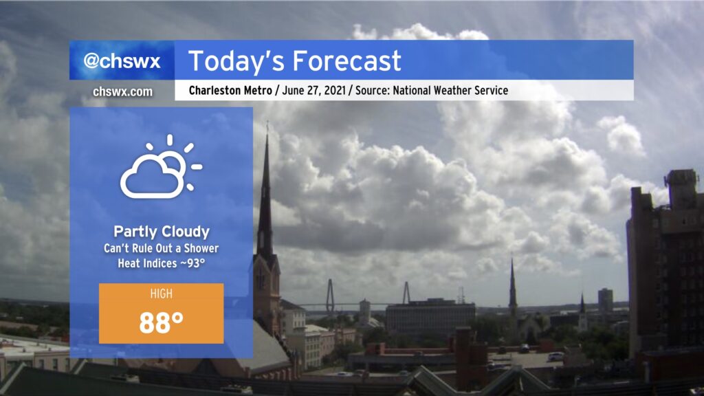
So far, Sunday has run a little drier than previous days without a better forcing mechanism to kick off showers and thunderstorms. While a shower or two cannot be totally ruled out, most of us should stay dry today as highs head into the upper 80s. Humidity will make it feel closer to the low 90s, especially right in the wake of the seabreeze passage this afternoon. Onshore flow will continue, and we should still see a decent breeze at the beaches throughout the day. All in all, not too shabby for the last Sunday in June. (Hard to believe, isn’t it?)
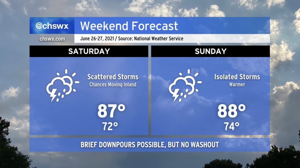
This weekend will feature scattered storms both days, with a little better coverage on Saturday as a trough moves inland. The good news is that it won’t rain all day, and there will be plenty of sunshine mixed in around the storms. Coverage becomes more isolated on Sunday, generally along and ahead of the seabreeze. Severe weather doesn’t look to be a major issue, but remember that all thunderstorms are dangerous thanks to the lightning they produce.
Temperatures will run a little warmer this weekend, but onshore flow will continue to keep them tamped down a few degrees below normal (about 90° this time of year). Mix in humidity and it’ll feel a little more like the low 90s in the afternoon. That’s pretty warm, but it could be so much worse in late June.
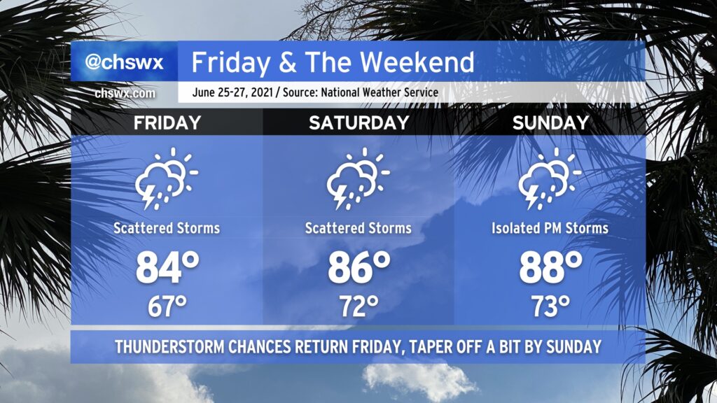
After a remarkably nice couple days behind a rare summertime cold front, said front retreats back over our neck of the woods as a trough of low pressure on Friday, bringing humidity, showers, and thunderstorms back into the weather picture. These elevated rain chances stick around to start the weekend before tapering off to more traditional isolated afternoon thunderstorm coverage on Sunday. Temperatures warm up from 84° on Friday to 88° on Sunday, but we are typically talking about 90s on a regular basis in late June, so we’ll take it.
One thing I’m not seeing is a total washout of the weekend by any stretch. Don’t cancel outdoor plans, just have a good backup ready to go in case you need it. Remember, all thunderstorms are dangerous because of the lightning they produce. If you see lightning or hear thunder, you’re close enough to be struck, so get inside as soon as you can if storms approach.
Coastal flooding will remain a possibility Friday and maybe Saturday nights as lingering astronomical influences and continued onshore flow could push tides above 7’ in the harbor in the late evenings. Be ready for additional bouts of coastal flooding and possible road closures as a result.