Jared Smith founded @chswx on Twitter in 2008 as an experiment in disseminating weather data through social media. In the ensuing decade-and-a-half, @chswx has provided live coverage of tropical cyclones, tornadoes, severe weather, and even a couple bouts of winter weather to the good people of Charleston, SC.
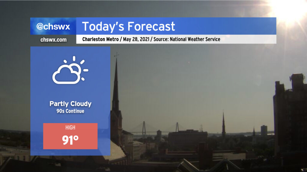
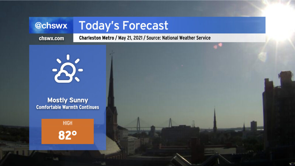
We’ll be back in the 90s today — perhaps for the last day for a little while — as the lingering effects of high pressure aloft remain for one more day before a front moves into the area on Saturday. Unlike yesterday, an earlier seabreeze progression will keep highs capped around 90-91°. (Yesterday’s high was 94°, tying Monday for warmest so far in 2021.) A shower or two can’t be totally ruled out as the seabreeze progresses inland, but with dry air remaining in place for one more day, coverage will be limited.
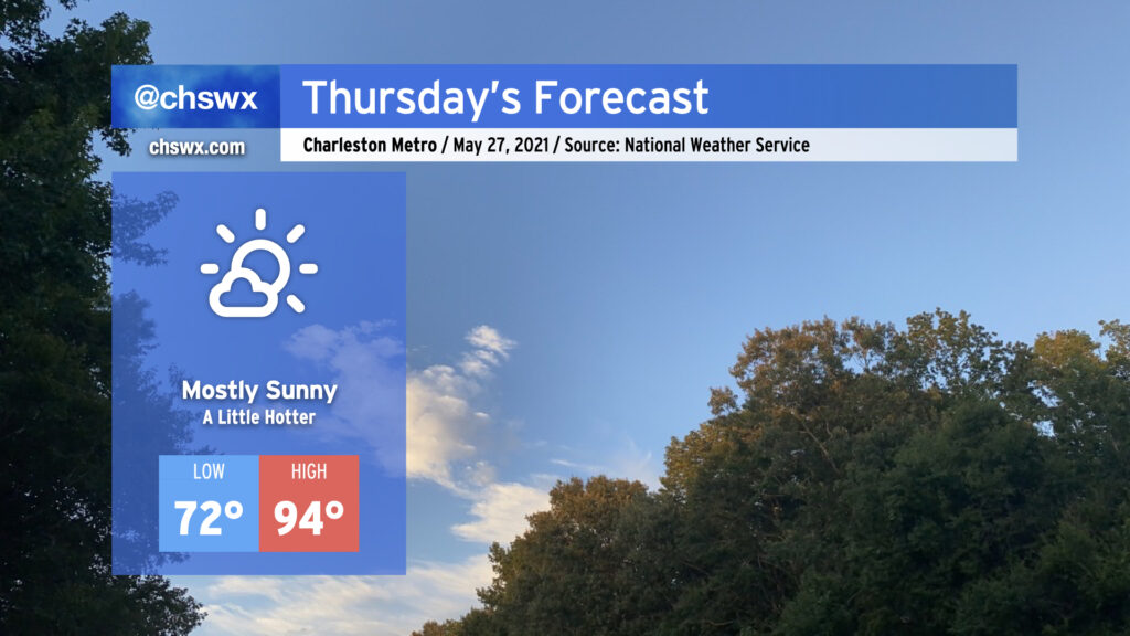
We’ll see a little more sunshine tomorrow, and that’ll add a little more heat to the forecast as a result. Temperatures will top out in the mid-90s away from the immediate coast on Thursday with winds out of the southwest turning more southerly as the seabreeze moves inland later in the day. A popup shower or two ahead of the seabreeze cannot be discounted, but the vast, vast majority of us continue our rain-free streak. We’ll see more shower and storm chances come into the picture over the weekend — hang in there, lawns and gardens.
High pressure will continue to slip a little more to the east today, allowing the resulting return flow to bring a little bit more humid air characterized by dewpoints in the mid-60s into the area. Once again, we look to remain mostly rain-free across the area; the best chance of a shower or two will be in northern sections of Berkeley and Dorchester counties near I-95 closer to a trough of low pressure. Otherwise, expect a mix of high clouds and fair-weather cumulus as temperatures rise into the low-to-mid-90s ahead of the seabreeze. Heat indices will be a couple ticks higher today, generally in the mid-90s in the afternoon, particularly right after the seabreeze and its associated dewpoint surge pass by.
Temperatures and humidity will continue to creep up for the next couple days before a cold front knocks down temperatures — and brings some isolated to scattered storms — for the Memorial Day weekend.
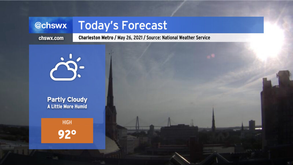
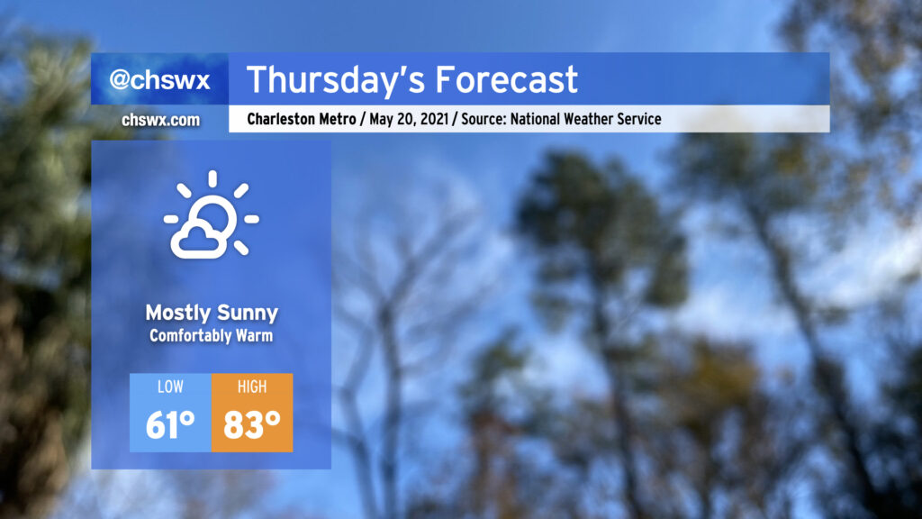
After topping out at 94° today to mark the hottest day of 2021 so far, we return to the 90s tomorrow as the stacked high pressure pattern remains in place. If you’re looking for rain, you’re not going to find it with the ridge keeping a lid on any deep convection. Humidity remains tolerable, so heat indices will not get too far out of bounds (though there may be a brief spike as the seabreeze pushes inland). That being said, low-to-mid-90s are still plenty toasty, so find shade when you can if you’re outdoors.
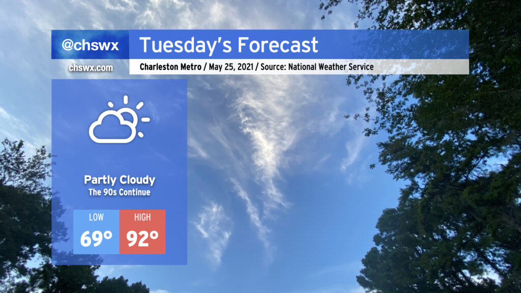
We stay in the 90s for the rest of the week, with temperatures turning hotter as we get into Thursday and Friday. Humidity will also be creeping up as high pressure slides offshore, bringing winds out of the southwest and pumping in 70°+ dewpoint air. Our next rain chances kick in over the weekend as a front gets close to the area.
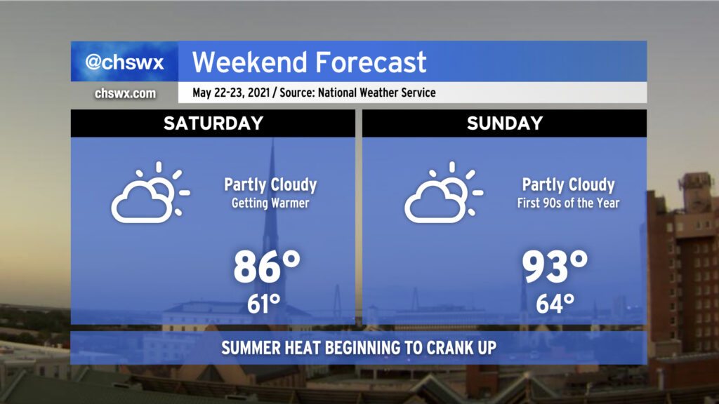
Summer heat will make its debut this weekend as high pressure at the surface and aloft dominates the weather picture. We’ll begin to feel a little of this on Saturday, but onshore flow will help keep temperatures capped in the mid-80s given a progressive seabreeze in the afternoon. Winds turn more westerly on Sunday, which will hinder the seabreeze’s inland progress and allow temperatures across much of the metro area to reach the low 90s for the first time this year. Temperatures will run cooler at the beaches — think upper 70s on Saturday and mid-80s on Sunday. The ridge aloft will keep a strong lid on any thunderstorms that try to fire, so don’t count on any rain over the weekend heading into the next several days. We look to get even hotter heading into the work week as the blocking pattern aloft looks to hang around for several more days.
We’ve got another comfortably warm day ahead as strong high pressure remains firmly in control of our weather. This morning’s satellite just shows some high clouds filtering in from the north, though we can expect some fair weather cumulus to develop this afternoon as highs get into the low 80s and the seabreeze circulation develops and moves inland. Temperatures will top out in the mid-70s at the beaches with onshore flow continuing. We could see some occasionally gusty winds behind the seabreeze, which is quite important particularly if you are trying to make the cut at a certain major golf tournament.
After today, we begin to warm up quite a bit, with the heat really turning on beginning Sunday. More on this later today.
Thursday is looking quite good with high pressure beginning to assert greater control over our weather. The periods of showers we saw over the past couple days will be a thing of the past, and temperatures will remain comfortably warm with onshore flow. After starting the morning in the 60s, expect highs in the low 80s away from the immediate coast. Dewpoints in the upper 50s keep heat indices in check, making for a nice mid-May day.
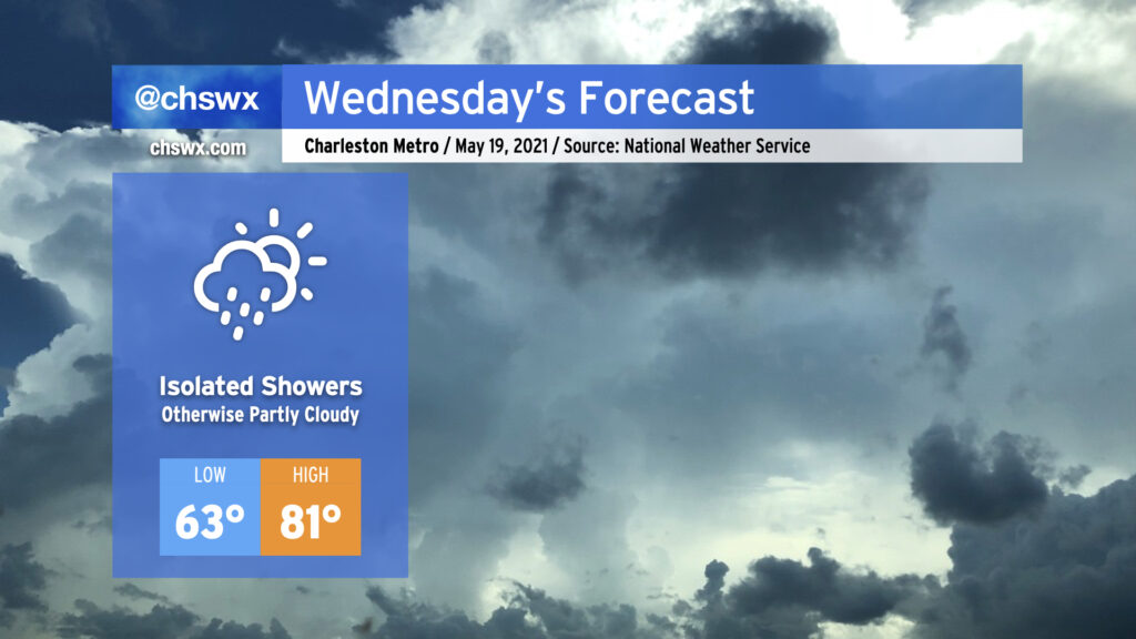
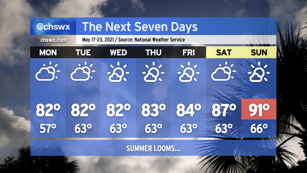
Wednesday looks quite a bit like today: a mix of clouds and sun with temperatures right around normal for mid-May. Much like today, a little bit of troughiness on the periphery of high pressure will come ashore during the day, potentially being a touchpoint for a shower or two. Don’t expect much in the way of widespread measurable rainfall — the vast majority of us will remain dry. Highs will top out in the low 80s away from the locally cooler coastline, and low 60s dewpoints will be reasonably comfortable.
After tomorrow, high pressure will take even firmer control of our weather. Expect temperatures to steadily rise into the end of the week through the weekend; we’re very likely going to see our first 90° days of the year beginning Sunday, with a bit of a heat wave persisting into next week as highs approach the mid-90s. It’ll certainly be the warmest stretch of 2021 thus far. Suffice to say, it’s safe to stow the winter wear for a few months!
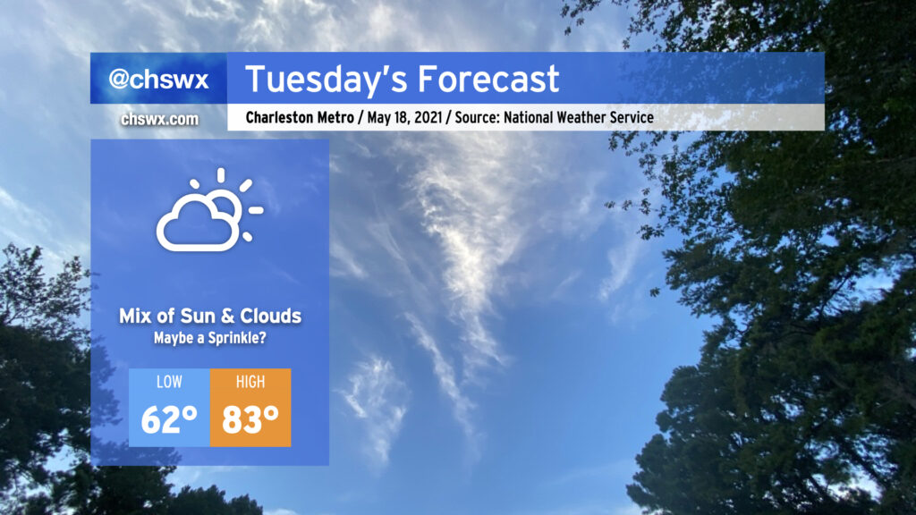
Despite a little more cloud cover, expect temperatures to run a little warmer Tuesday in part due to a little more moisture being available and the overall modification of the airmass that settled in behind the front last week. Temperatures will still run generally around, if not slightly below, normal for mid-May, with cooler air at the coast keeping highs at the beaches in the 70s.
Despite high pressure continuing to build across the area, one cannot totally rule out a shower or two developing on the southern extent of the ridge. The better rain chances will be south of us, but a few sprinkles aren’t out of the question. All in all, the vast, vast majority of us stay dry tomorrow — and we’ll stay that way through at least early next week.
The upcoming work week will feature temperatures right in line with what we would expect from the third week in May with low-to-mid-80s quite common away from the coast. Humidity will be creeping up a little bit beyond Monday, which will be felt primarily through slightly warmer low temperatures in the low 60s. Keep the sprinklers on standby throughout the week as you’re going to need them with dry weather expected for the next seven days thanks to high pressure at the surface and aloft keeping a lid on afternoon convection. This will expand on this spring’s rainfall deficit, which stands at 2.19″ at publish time. (We are hanging on to a 0.66″ surplus for the year, but this should be erased by the end of this week.)
As we reach the weekend, we’ll start to see the heat kick up a notch as the ridge aloft strengthens. The first 90° temperature at the airport in 2021 should be achieved by Sunday; if this ends up being the case, it’d be the latest first 90° day since 2005. Dewpoints in the low 60s will keep heat indices in check for now, but it’s only a matter of time before the humidity begins to kick in.