Jared Smith founded @chswx on Twitter in 2008 as an experiment in disseminating weather data through social media. In the ensuing decade-and-a-half, @chswx has provided live coverage of tropical cyclones, tornadoes, severe weather, and even a couple bouts of winter weather to the good people of Charleston, SC.
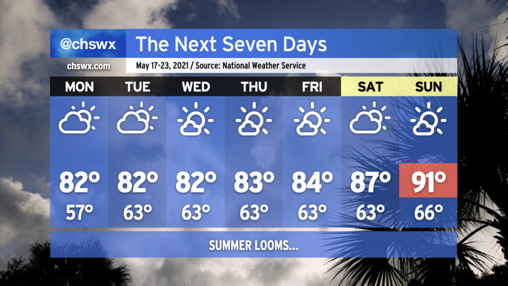
The upcoming work week will feature temperatures right in line with what we would expect from the third week in May with low-to-mid-80s quite common away from the coast. Humidity will be creeping up a little bit beyond Monday, which will be felt primarily through slightly warmer low temperatures in the low 60s. Keep the sprinklers on standby throughout the week as you’re going to need them with dry weather expected for the next seven days thanks to high pressure at the surface and aloft keeping a lid on afternoon convection. This will expand on this spring’s rainfall deficit, which stands at 2.19″ at publish time. (We are hanging on to a 0.66″ surplus for the year, but this should be erased by the end of this week.)
As we reach the weekend, we’ll start to see the heat kick up a notch as the ridge aloft strengthens. The first 90° temperature at the airport in 2021 should be achieved by Sunday; if this ends up being the case, it’d be the latest first 90° day since 2005. Dewpoints in the low 60s will keep heat indices in check for now, but it’s only a matter of time before the humidity begins to kick in.
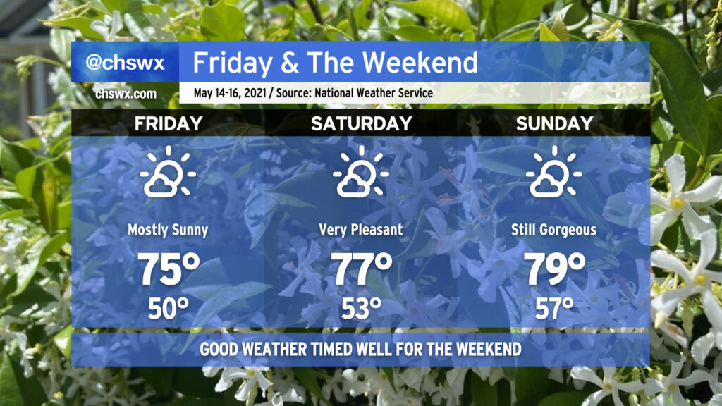
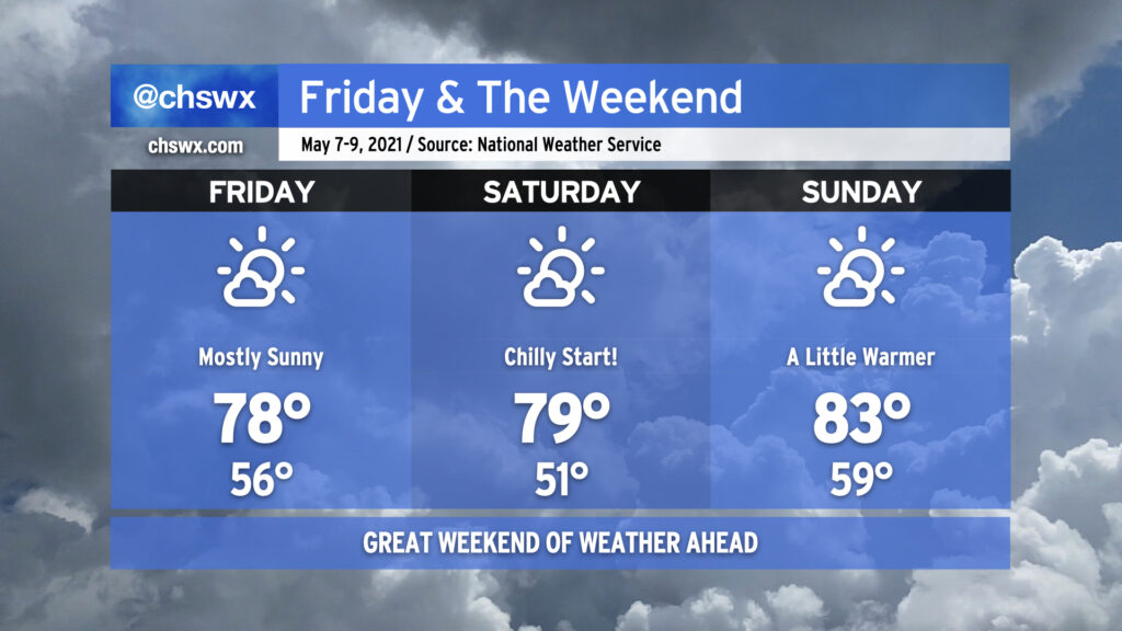
After a nicer-than-expected Thursday, we have a pretty outstanding mid-May weekend coming up in the Lowcountry. High pressure will remain the dominant player in our weather both at the surface and aloft. Onshore winds will keep temperatures quite comfortable, and deep-layered dry air will help mix dewpoints out into the 40s during daytime heating, providing for a comfortably dry atmosphere particularly on Friday and Saturday. The airmass will continue to moderate through the weekend, and we should be back to around 80° by Sunday. Overall, this is a great opportunity to get out and about — summer and its associated muggy heat will be here before you know it.
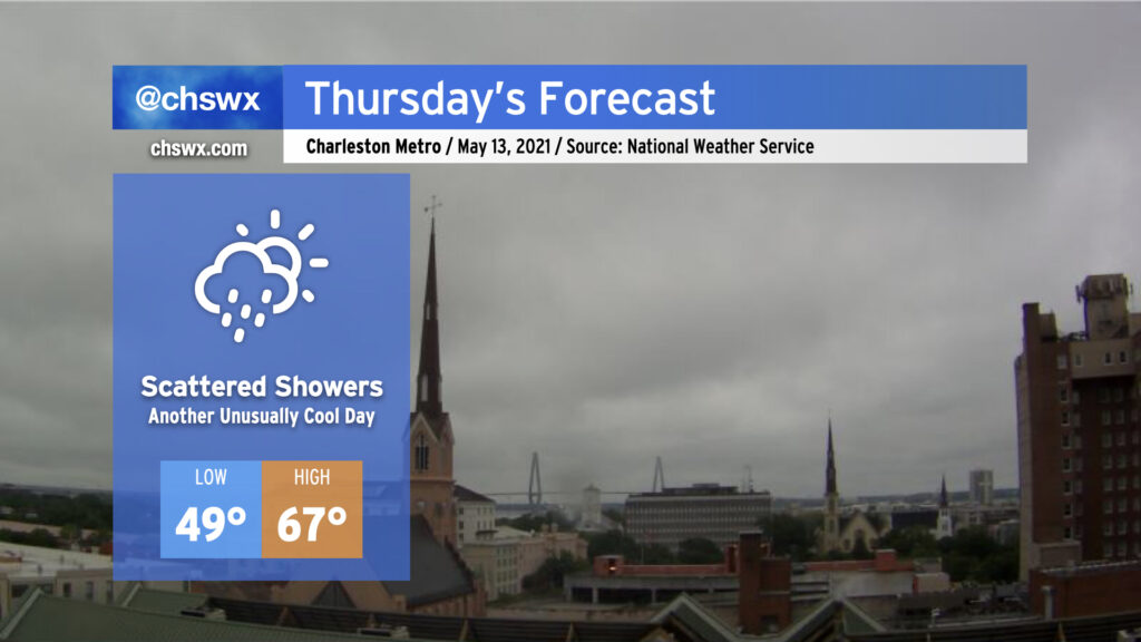
A late-season cold air damming wedge will remain in place on Thursday, keeping temperatures well below normal for mid-May and shower chances in place as low pressure develops off the Florida and Georgia coasts. We’ll start the day in the upper 40s to around 50° with highs — provided the wedge scours away a bit — topping out in the mid-60s. That may be generous, though. Breezy northeast winds will continue within the wedge throughout the day with persistent cloud cover. There’s a chance we could see some breaks in the clouds later in the evening, but that’s somewhat up in the air based on how much moisture could be trapped within the wedge.
As mentioned before, scattered showers look probable, with even some drizzle possible especially if the wedge remains entrenched. Suspect that the best rain chances are going to be closer to the coast and will be greatest in the morning. As low pressure pulls away, drier air will punch into the area, but it may take time to erode the layer of overcast just off the surface.
Fortunately, this will be relatively short-lived — clouds will begin to break on Friday, and by the weekend we’ll see mostly sunny skies and temperatures in the mid-to-upper 70s. Hang in there!
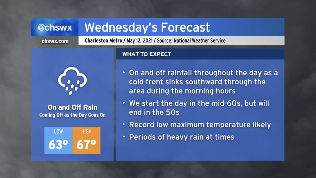
We will start Wednesday in the low to mid-60s across the area with showers and maybe a thunderstorm or two ahead of a cold front. Said front will sink southward through the area during the morning, and we will cool off as the day goes on. Expect our high in the mid-60s to be recorded before noon, with temperatures falling into the 50s during the afternoon and evening hours. Rain will be off and on throughout the day, so just be prepared with the rain gear as needed. (You might want to go with something fleece-lined.) Models suggest we may see a little break in the rain as we get into the evening hours once low pressure develops offshore and heads away, which may not be the worst thing for the commute home.
It looks like we will set a new record low maximum temperature on Wednesday. The current coldest high recorded at the airport on May 12 is 69° set in 1963. The current forecast high of 67° will clear that bar fairly comfortably. All will hinge on how quickly the cold front can get through the area during Wednesday morning.
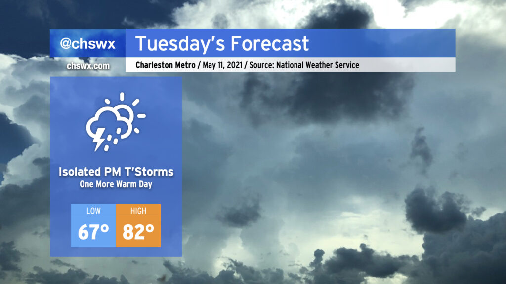
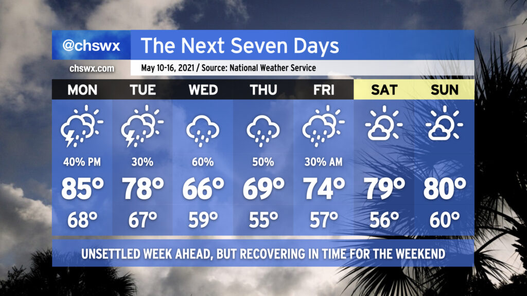
We have one more day in the 80s on Tuesday before a backdoor front sinks south of the area Tuesday evening, bringing quite a cooldown to the area Wednesday and Thursday. Isolated showers and thunderstorms will be possible as the front sags southward across the area, particularly in the afternoon.
Better rain chances arrive overnight into Wednesday, as moisture overruns a weak wedge of high pressure, setting up widespread precipitation for Wednesday and potentially into Thursday. An excessive rainfall event is not expected — indeed, this rain will be quite welcome as we continue to experience abnormally dry conditions across the Lowcountry. The persistent rain falling into the wedge will keep temperatures pinned down in the upper 60s. Record low maximum temperatures of 69 on Wednesday (set in 1963) and 68 on Thursday (set in 1996) are certainly in jeopardy. (At least it’s May and not January, where the wedge is often much chillier and the rain much more unpleasant!)
Temperatures rebound beginning Friday, and we continue to look really good for an extremely pleasant weekend of weather. (It’s never too early to think about the weekend, after all.)
After an excellent weekend of weather, we’re back into a bit of an unsettled pattern for the work week. Monday should be mostly dry to start, but showers and thunderstorms will be possible in the afternoon as mid-level energy works its way through the area. Highs will top out in the mid-80s with humidity making it feel a little warmer.
We’ll begin to see a frontal boundary sink into the area on Tuesday, bringing another chance for scattered showers and thunderstorms throughout the day. As the front sinks southward, a wedge of high pressure will begin to build in from the north and northeast, spelling a chilly (by mid-May standards) couple days for Wednesday and Thursday with highs only topping out in the mid-to-upper 60s. Rain looks likely as moisture overruns the wedge, and we sure could still use it as abnormally dry conditions persist across the Lowcountry.
By Friday, we begin to see drier high pressure reassert itself. Rain chances will remain with us especially in the morning before clearing the way for another gorgeous weekend of weather. (I like it when the pattern works out like this!)
No complaints about this weekend’s weather: Solid late-spring fare for the Lowcountry, with low humidity, a chill in the air to start each morning, and comfortably warm temperatures each afternoon under plenty of sunshine with just some fair weather cumulus at times providing a little natural shade. (Mom will love it.)
If I had to pick a day out of the three for the best weather, I’d say Saturday is probably it for its wide spectrum of temperatures, low humidity, and relatively calm winds. Friday and Sunday look to be a bit on the breezy side with high pressure building on Friday and beginning to depart on Sunday.
We’ll need to monitor weather conditions for enhanced fire danger over the next few days as we still remain abnormally dry. A Fire Weather Watch is in effect for Friday due to very low humidity and winds gusting up to 30 MPH at times, and I wouldn’t be surprised to see fire danger remain elevated into Sunday before our next rain chances arrive Monday. Please don’t burn outdoors as flames could quickly get out of hand. Otherwise, though, enjoy a nice weekend!
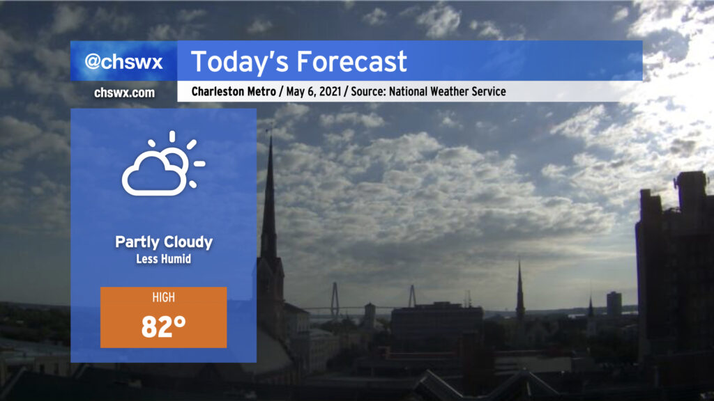
A cold front came through early this morning and you can really feel the difference out there! The air is much drier this morning in comparison to yesterday, with dewpoints down into the upper 50s and low 60s as opposed to the mid-to-upper 60s as they were 24 hours ago. Partly cloudy skies will continue today as low pressure organizes off the coast later today, with a very tiny chance of a shower this evening. We’ll see a second round of dry air punch in overnight, making for excellent weather especially Friday into Saturday.
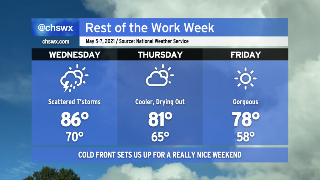
We’ve got one more day of thunderstorm chances this week before a cold front sweeps them out of here by Thursday, setting us up for a fine end to the work week and a nice weekend.
First, though, we need to handle Wednesday. Wednesday is going to be a tricky day in the forecast; scattered showers and thunderstorms certainly seem possible, but the overall coverage of storms is less certain. It appears that thunderstorm activity along the Gulf Coast will rob our area of moisture, which should keep coverage and intensity a tick lower than we’ve seen over the past couple days. Still, a strong to severe storm or two cannot be totally ruled out, either.
What is certain about Wednesday is that it’ll be another warm and muggy day. Temperatures will head into the mid-80s once again, with heat indices running around 90°.
The cold front swings through overnight Wednesday/early Thursday morning, and the airmass begins to change in response. We’ll see partly cloudy skies on Thursday with highs topping out in the low 80s with a little lower humidity. This airmass really begins to take hold later Thursday into Friday, when temperatures will start in the upper 50s and warm to comfortable temperatures in the upper 70s with lower humidity. This nice weather hangs around into the weekend, particularly on Saturday. Enjoy it — we don’t have too many more of these “cool” snaps left until later this year!
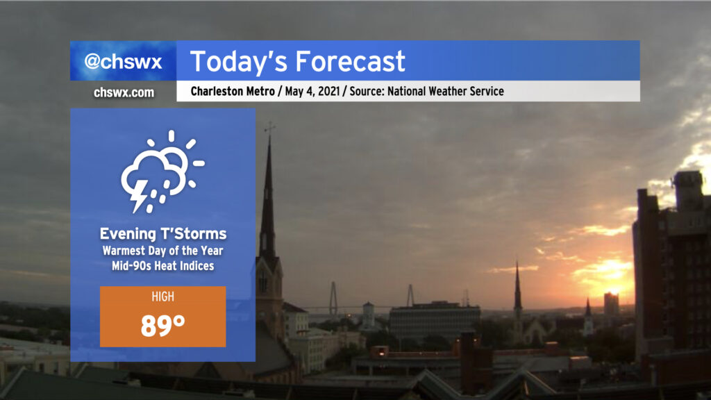
After the high topped out at 88° yesterday, we look to take at least one step closer to 90° today with another very summer-like day ahead. Humid air will allow heat indices to head up into the mid-90s for the first time this year. We’ll stay dry for much of the day absent any triggers for thunderstorm development, with our best chance of showers and thunderstorms coming later this evening (much like last night). Once again, we’ll be looking to our west throughout the day to nail down timing of any showers and thunderstorms that impact the area. Much like last night, there will be a damaging wind risk as well with the strongest thunderstorms, so keep an ear out to forecast updates throughout the day.