Jared Smith founded @chswx on Twitter in 2008 as an experiment in disseminating weather data through social media. In the ensuing decade-and-a-half, @chswx has provided live coverage of tropical cyclones, tornadoes, severe weather, and even a couple bouts of winter weather to the good people of Charleston, SC.
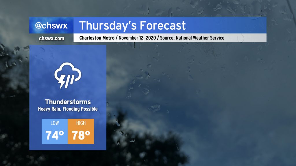
Some pretty heavy rain for any time of year, much less November, is in store for Thursday. Deep tropical moisture will continue to blanket the area ahead of a cold front. At the same time, Tropical Storm Eta will move across northern Florida and into the Atlantic, weakening while undergoing a post-tropical transition. Be ready for the potential for flooding due to heavy rain, especially around times of high tide (4:54am, 5:10pm). Some tidal flooding cannot be ruled out, either.
Temperatures are just not going to move much tomorrow with rain expected to be in place for a fair bit of the day. Highs will top out in the upper 70s after a low in the mid-70s, which would absolutely destroy the record high minimum temperature of 68° set in 1975. Our lows have been rewriting the record books for the last few days due to such abnormal warmth. (A normal November low based on 1981-2010 climatology is 48°!) Fortunately, there is some relief in sight with the cold front.
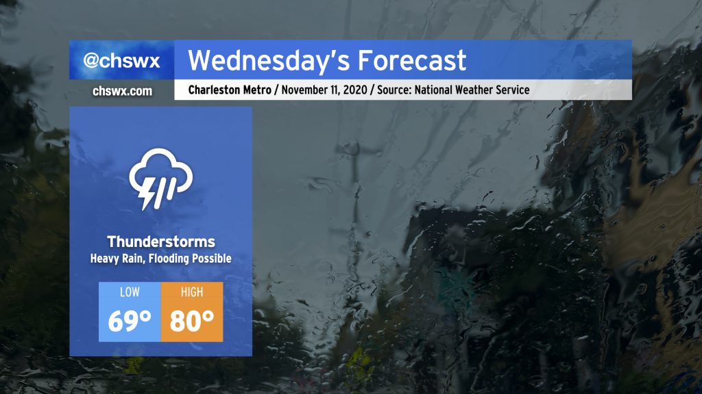
Periods of heavy rain look to continue for the next few days as moisture from Tropical Storm Eta in the Gulf continues to overspread the area with a stalling cold front to our west. For Wednesday, showers and thunderstorms continue to overspread the area throughout the day. It’ll be muggy, with highs once again topping out around 80° after starting out near 70°, which may threaten record high minimum temperatures once again.
As always, when heavy rainfall is in the forecast, we need to watch around times of high tide for particularly acute flooding in downtown Charleston. High tides will be at 3:55am and 4:13pm on Wednesday. Given continued onshore flow, the Wednesday afternoon high tide could tip briefly into coastal flood stage as well, so that will be something to watch carefully.
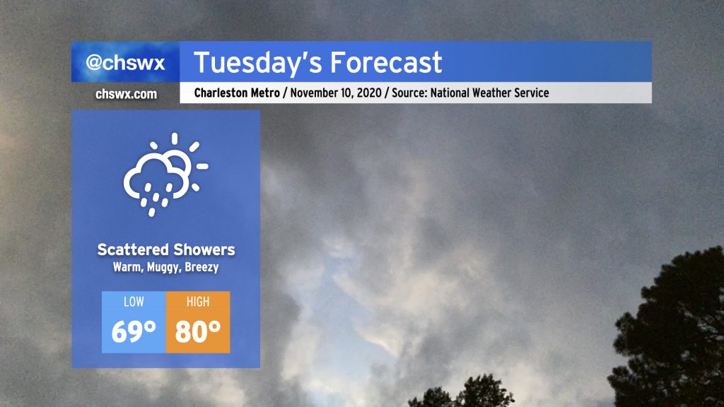
Expect a bit more in the way of cloud cover and showers for Tuesday as a moisture plume courtesy of Tropical Storm Eta begins to spread northward. Temperatures will remain rather warm for this time of year. We’ll start the day in the upper 60s to low 70s (especially near the coast). Temperatures will top out in the low 80s, with periods of cooling where showers develop. Shower chances will continue to ramp up with time on Tuesday, with thunderstorms becoming likely as we head into Wednesday.
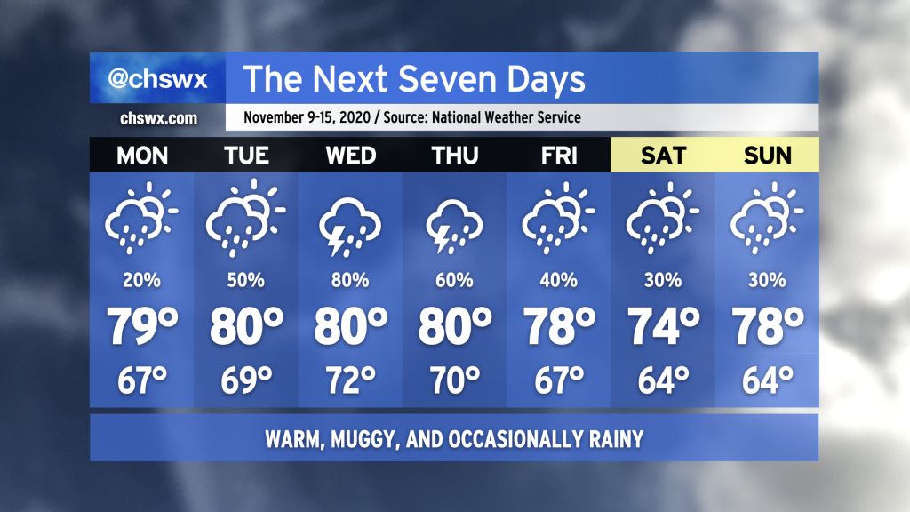
Fall’s hiatus continues this week as we sit between high pressure to the north and Tropical Storm Eta to the south. Monday looks to be the driest day of the week with just a slight chance of showers throughout the day. Rain chances head up into Wednesday as tropical moisture associated with Eta gets drawn up into the area by a frontal system approaching from the west. This front looks to stall out by the end of the week, keeping a chance for showers in the forecast through the weekend. (Eta could make the weekend a little more wet and windy, so consider that forecast somewhat low-confidence at the moment.)
Temperatures will remain rather warm for early to mid-November. NWS notes that some record high minimum temperatures could fall this week, with lows in the 70s forecasted especially Wednesday and Thursday. (For contrast, the typical high temperature this time of year is around 71-72°.) Highs will generally run in the upper 70s to low 80s, roughly 8-10° above normal for this time of year.
If you’re looking for a shift back into Fall, this week ain’t it. While we may cool off as we get into the following week, long-range guidance continues to hit on above-normal temperatures remaining the norm (as one would expect in a La Niña winter, which tends to trend warmer and drier in the Southeast).
Get your sweaters ready, at least for Monday and Tuesday morning: A cold front swinging through tonight will usher in the coolest airmass of the season thus far. The high of 59° forecast on Monday would be the coolest high since early March, and this is happening despite full sunshine. We could see some frost develop away from the barrier islands Tuesday morning as temperatures dip into the 30s. We’ll rebound to near 70° in the afternoon under mostly sunny skies, making the weather a non-impediment for Election Day.
Temperatures recover fairly quickly as we get into mid-week; we’ll be up into the 70s by Wednesday, and that continues for the rest of the week. We’ll gradually see a warmer and more humid airmass get into the area, with lows creeping up into the 60s by the weekend. Isolated to scattered showers become possible later this week, but so far, not seeing a prolonged rain event.
We’ll close out this rather warm month of October (eighth warmest on record as of this evening) with one last stretch of warm, muggy days before a storm system rolls through the area Thursday into Friday.
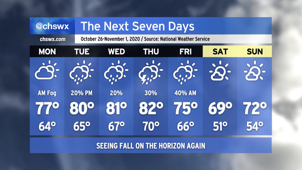
Temperatures will head back above normal this week with shower chances coming back into the picture starting Tuesday. Showers will be isolated to scattered at best for most of the week as a coastal trough persists. Onshore flow will keep dewpoints up, making for a warm and humid mid-to-late October week. Expect highs in the 80s just about every day with lows in the mid-60s. (Closer to the coast, take a couple degrees off the high and add it to the low.)
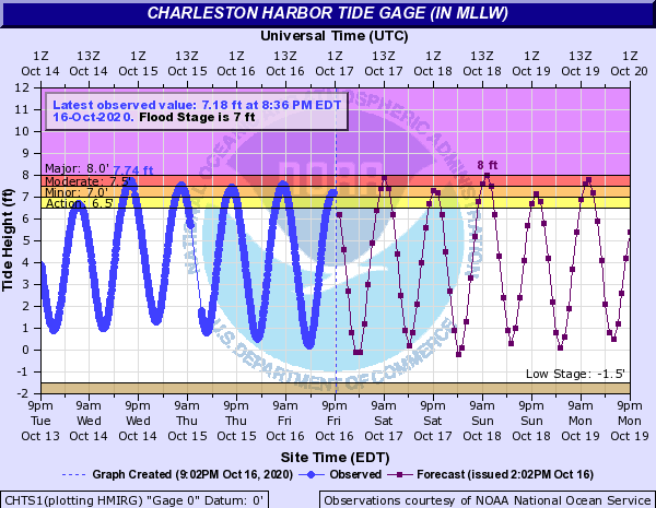
Astronomical influences and onshore winds will send water levels in Charleston Harbor well into flood stage at times of high tide this weekend. Moderate to major coastal flooding (8.0′ MLLW) will be possible with each morning high tide through at least Monday, while minor flooding is expected with each evening high tide. Road closures will be possible at times of high tide, with some routes becoming temporarily cut off due to salt water inundation.
The remnants of Delta are on their way out, giving way to a series of fronts over the next few days that will gradually ease us back into fall weather. First, though, we will still contend with elevated heat and humidity Monday into Tuesday with highs in the mid-80s and dewpoints in the low 70s. Then, a front will wedge in from the north, cooling us off a little for Wednesday and Thursday with highs only topping out in the low 80s. A better shot of cooler and drier air arrives late Friday into early Saturday — perhaps with some showers — as another area of high pressure builds in from the west. This one will bring us back to fall, with upper 60s to around 70° for Saturday and low 70s for Sunday.
Temperatures this week will run a little warmer than last week with a bit more moisture in the area. We’ll start off the work week with a pleasant mix of sun and clouds and a high in the mid-70s. A little more moisture moves in with a trough of low pressure on Tuesday, bringing some shower chances to the area. Temperatures warm into the low 80s for Wednesday and Thursday before high pressure wedges in, with moisture riding over the top of the wedge bringing some shower chances into the cards. Overall, not too shabby, if not quite as crisp as it felt last week.