Jared Smith founded @chswx on Twitter in 2008 as an experiment in disseminating weather data through social media. In the ensuing decade-and-a-half, @chswx has provided live coverage of tropical cyclones, tornadoes, severe weather, and even a couple bouts of winter weather to the good people of Charleston, SC.
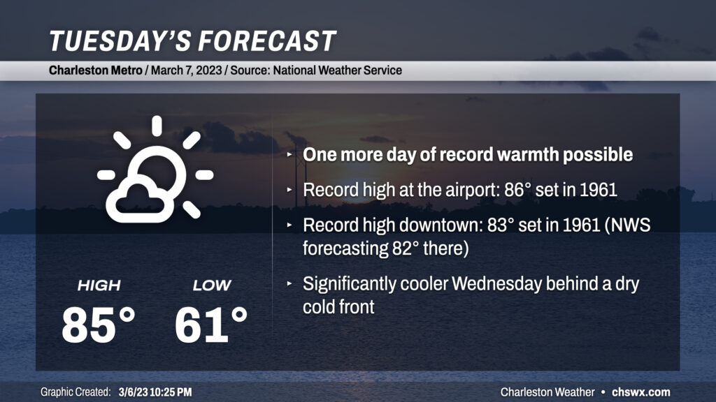
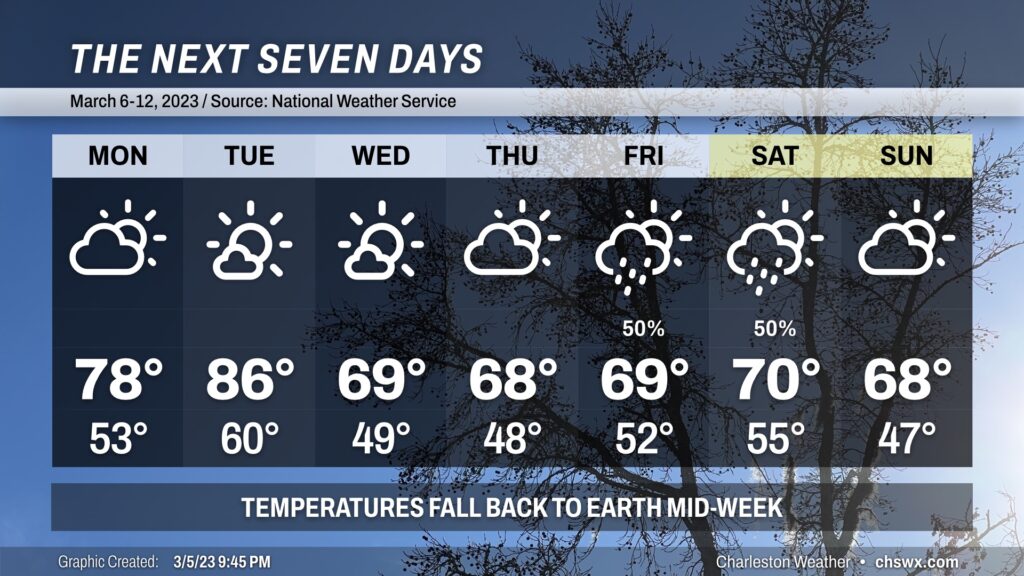
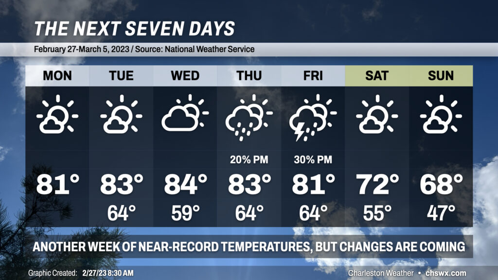
We’ve got one more day in the 80s coming up for Tuesday before the May-like warmth takes a backseat to more seasonable March temperatures. Temperatures will soar into the mid-80s in most spots except at the immediate coast as winds out of the west and northwest pin the seabreeze. We look to threaten record highs both at the airport and at downtown Charleston one more time — 86° and 83°, respectively, both set in 1961 — before a cold front sweeps through the area in the late afternoon/early evening hours.
Dewpoints will fall throughout the day as low-level moisture mixes out into an increasingly dry airmass. Once the front gets through, temperatures should hold in the upper 70s before falling quickly once daytime heating is lost. The front will pass through with little fanfare other than a wind shift more toward the north and then the northeast as cool high pressure builds in behind it. We’ll bottom out on Wednesday in the mid-to-upper 40s — easily the coolest start to a day since mid-February — and only top out in the mid-to-upper 60s in the afternoon, perhaps as much of a 20° drop from Tuesday’s high!
If you’ve enjoyed this stretch of exceptionally warm weather for this point in the year, savor the next couple days as we will be cooling off by mid-week, with this cooler weather looking to persist for a while as the pattern flips more favorably for below-normal temperatures for much of the continental US.
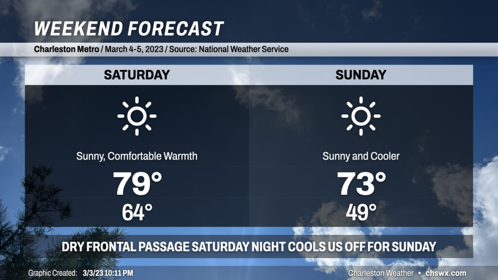
If it weren’t for the pollen, I’d unequivocally endorse this weekend as a great one to get out and about. Once a cold front and its associated thin line of showers clears the area overnight, skies will clear and give us a brilliant couple days. We start Saturday in the mid-60s as some of the slightly cooler and drier air lags a bit, but we’ll see dewpoints mix out nicely as the day goes on, allowing for a comfortably warm day as temperatures approach 80° but with less humidity than the past few days.
A secondary cold front will come through overnight Saturday into early Sunday morning. It will be starved of moisture, so a dry passage is expected. The airmass behind this front is more noticeably cooler and drier. You’ll certainly feel the difference when we start Sunday around 50° — the coolest start to a day since the temperature bottomed out at 48° on February 20 — and only see temperatures rise into the low-to-mid 70s in the afternoon despite pristine skies. We’ll see some occasionally breezy conditions both days, but other than that, really nice weather is in store with a little more seasonable feel on the way.
Changes are coming in the forecast as we get through the weekend as the abnormal warmth for this point in the year finally starts to get blunted a bit.
We had another record warm day in the Lowcountry today. The high at the airport reached 86°, breaking the record of 83° set in 2017. Despite the seabreeze making more of an inroads today, Downtown Charleston appears to have tied its record high as well, topping out at 79° to match the mark on March 1, 1918.
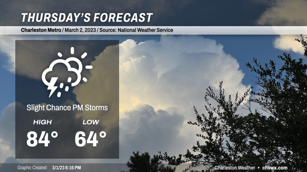
We will have one more day of record-challenging temperatures on Thursday before some of the extreme warmth begins to subside. Highs should top out once again in the mid-80s, getting within spitting distance of the record high of 85° set in 1997. This is despite some additional cloud cover and perhaps a few showers and maybe a thunderstorm in the afternoon and evening hours as southwesterly winds ahead of a cold front continue to strengthen across the area. Most of us will get the day in rain-free, though, with the better risk of showers and storms to our north near a frontal boundary. (This might or might not be such a great thing considering the absolute onslaught of pollen that continues across the Lowcountry!)
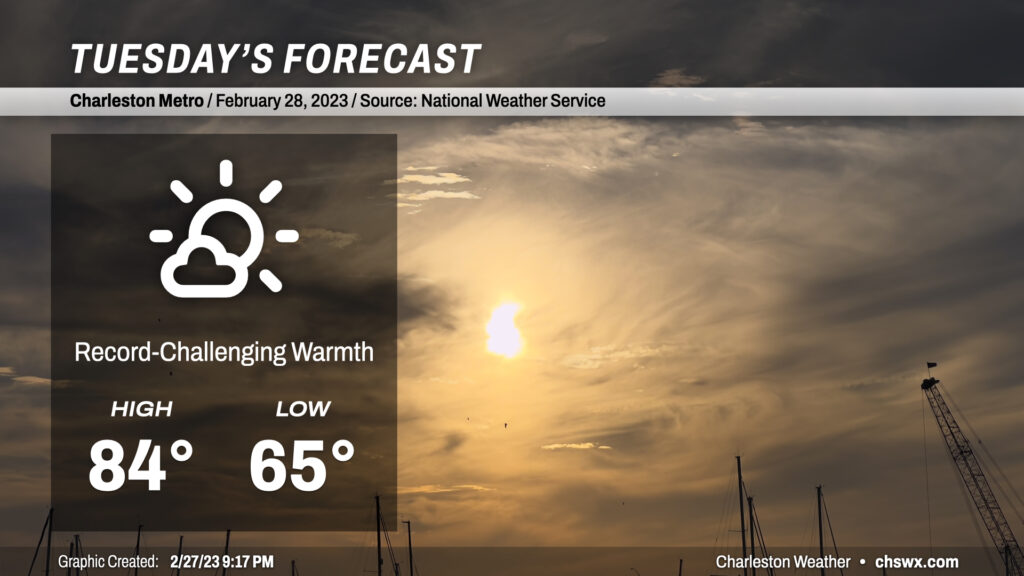
February — and meteorological “winter” — will close on an abnormally warm note. Today’s high of 86° at the airport tied the record high first set in 1962. This stretch of record warmth looks to continue as we kick off March and meteorological spring, but there are signs that cooler weather is on the horizon, both this weekend and in the longer term.
Mostly sunny skies and westerly winds will combine to bring temperatures in striking distance of additional records on Tuesday. Highs across the area will generally top out in the low-to-mid-80s, with the warmest weather away from the coast. The seabreeze is going to have a tough time getting too far inland with the persistent and occasionally breezy west winds, which should spread the 80s onto the barrier islands. The beaches should run much cooler, with temperatures in the low-to-mid-70s right on the coast.
The record high for Tuesday is 86°, set in 1962. While we may not tie or break that record, the record high minimum temperature of 63° set in 2021 certainly looks attainable.
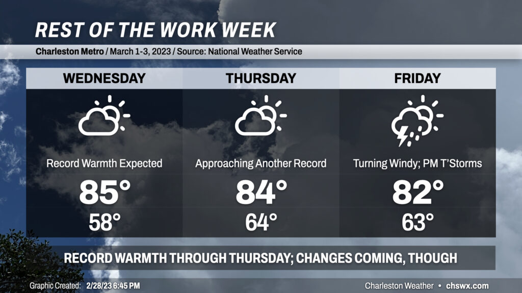
We will continue to get near record highs for a good chunk of the rest of the week before a cold front — and perhaps some strong storms — approach the area Friday.
We’re back in the 80s starting today as much warmer-than-normal temperatures continue across the Lowcountry. We may once again threaten record highs over the next few days with temperatures topping out in the low to mid-80s each day through Friday. Lows in the mid-60s most days (except for Wednesday, the result of a weak front) will also challenge record high minimum temperatures across the region — indeed, this remains unusually warm weather for this point in the year and The Pollening should, unfortunately, continue apace.
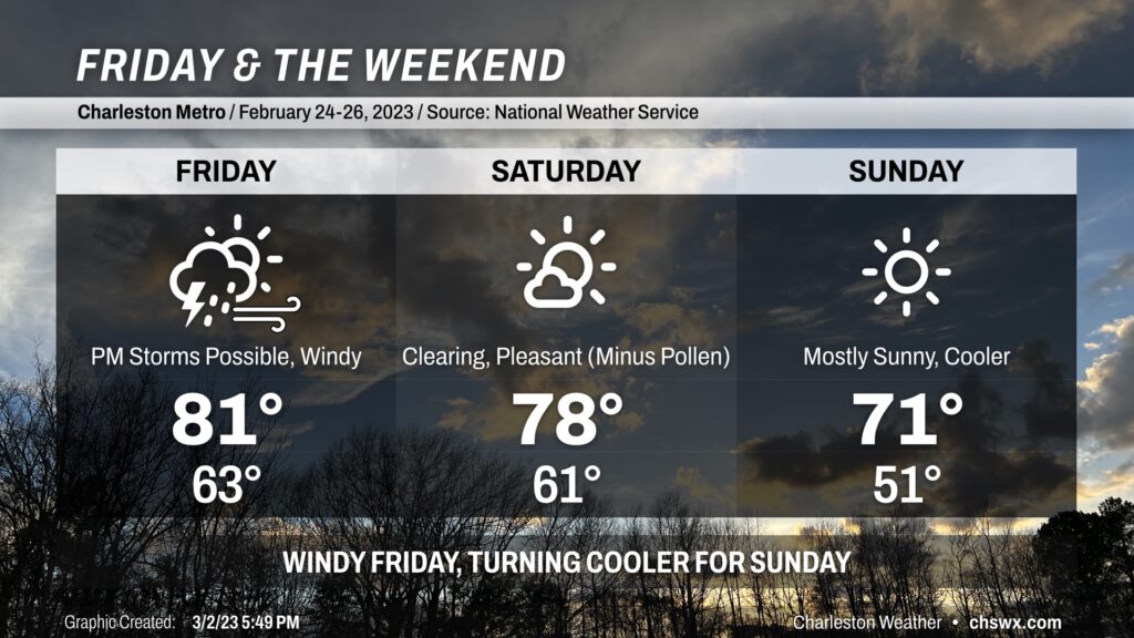
Changes are coming later this week for the weekend, though. A strong cold front looks to approach the area Thursday into Friday, which will shift the airmass more substantially and get temperatures back within striking distance of early March normals. This will come with the risk for strong to severe thunderstorms on Friday afternoon, with strong winds expected even outside of thunderstorms. We’ll want to watch this closely for later this week, but there’s still model difference right now in the exact track of the storm system. Stay tuned.
Regardless of what pans out with the severe weather threat, we’ll have a much more seasonable — but still warmer-than-normal — weekend ahead with highs topping out in the low 70s Saturday and the upper 60s on Sunday. Lows will fall back to earth as well, with the first lows in the 40s since February 20 in the forecast. The good news in all this is that we should see plenty of sunshine this weekend to go along with the more comfortable temperatures. (Just take some precautions against the pollen if you are sensitive to it.)
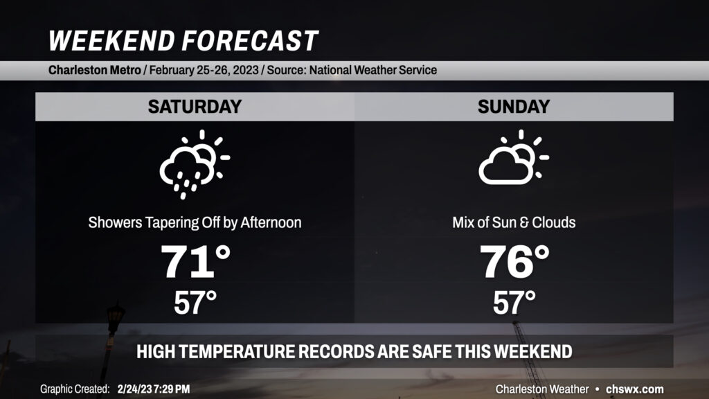
Our recent string of record warmth, punctuated by a high of 86° today that breaks last year’s record of 84°, takes a pause this weekend as a backdoor cold front stalls out near the area. Showers filling in tonight will peak overnight as low pressure develops along the coast. As this low pressure pulls away during the day Saturday, so will the chance for rain. Bottom line for precipitation: Keep rain gear handy, but you may not end up needing it. Cloud cover and high pressure wedging in from the north will keep temperatures well below where they have been recently, but still above normal, peaking in the low 70s.
Said front lifts back north of the area on Sunday, bringing in a little more in the way of sunshine and warming temperatures back into the mid-70s. This is roughly 10° above normal for this point in the year, but the record books will remain intact as the record high of 83° set in 1996 looks to remain safe. By Monday, we should be back into the 80s as ridging re-establishes itself aloft.
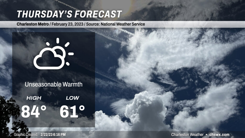
Our warm spell peaks on Thursday on the heels of a second consecutive day where we’ve at least tied the record high. Temperatures will soar into the mid-80s, getting within striking distance of the record high of 86° set just last year. We’ll see a few more clouds ahead of an approaching backdoor cold front, but we look to remain rain-free for one more day.