Jared Smith founded @chswx on Twitter in 2008 as an experiment in disseminating weather data through social media. In the ensuing decade-and-a-half, @chswx has provided live coverage of tropical cyclones, tornadoes, severe weather, and even a couple bouts of winter weather to the good people of Charleston, SC.
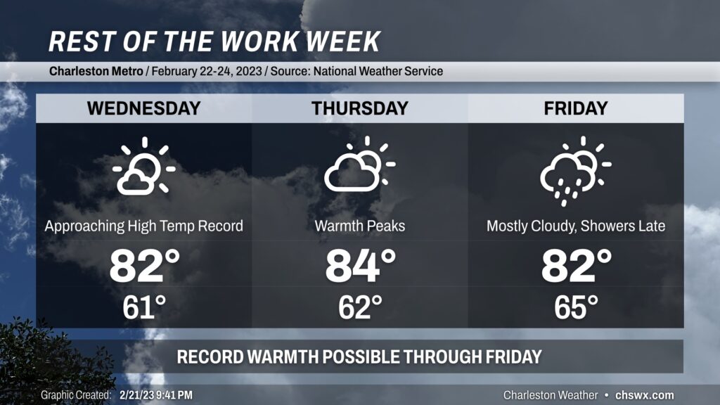
After setting a new record high on Tuesday (83°, breaking the record of 82° last set in 2019), we’ll take another shot at the record books on Wednesday as highs look to once again top out in the lower 80s. The NWS forecast explicitly ties the record high of 82° last set in 2018, and it’s certainly plausible we’ll break that record.
Thursday will represent the peak of the warmth before a cold front gets closer on Friday. The record high of 86° on Thursday, while not explicitly forecast to be broken, will still be well within striking distance and has a chance to fall. Friday’s high of 82° will also be in range of the record high of 84°, though that record may be a little tougher to realize with increasing cloud cover ahead of a cold front that will cool things down markedly for Saturday (and bring some rain chances, as well). That cooldown will be short-lived, though, as we head back well above normal for Sunday and beyond.
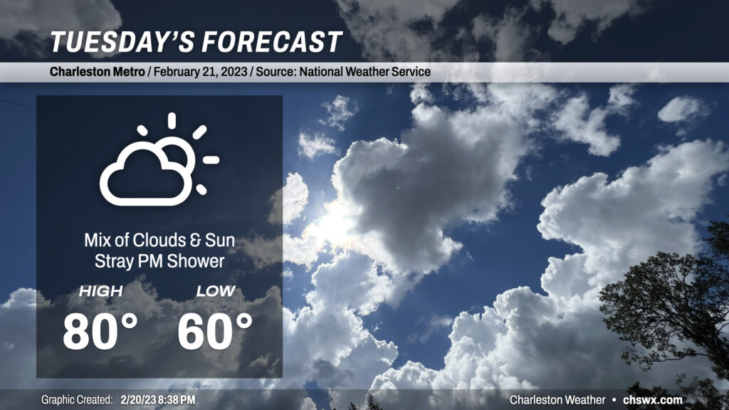
After highs topped out around 78° today, we’ll once again challenge (and likely reach) 80° for the third time so far in 2023 on Tuesday as high pressure continues to build across the area. We’ll be in a mix of clouds and sun throughout the day with perhaps a shower or two later in the day/early evening as some upper-level energy glances the area.
The record high for Tuesday is 82°, first set in 1991 and then tied in 2019. We will get within striking distance, especially if cloud cover thins out a bit more. It’s also worth noting that the forecast low temperature of 60° is only five degrees below the normal high for this point in the year, and is just one degree below the record high minimum temperature of 61° set in 1989.
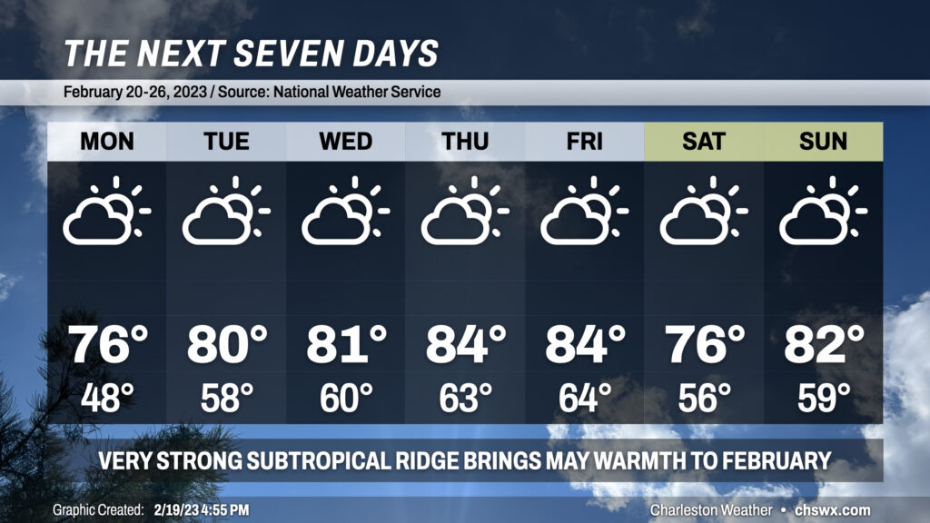
High pressure at the surface and aloft will keep very warm temperatures in the forecast for much of the week with no rain to show for it as strong subtropical ridging more characteristic of late spring/summer builds across the area. Put another way: It’s a scary week to be a record high at the North Charleston climate site.
The bad news is that we’re going to see some rain on Friday (probably midday through mid-afternoon). The good news is that it will be short-lived, and that we will have a rain-free weekend for the first time since the first weekend of 2023!
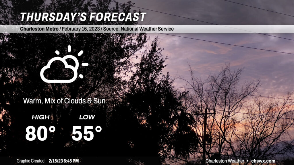
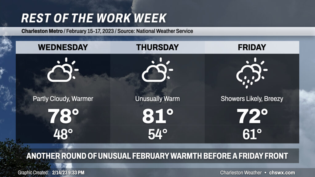
Temperatures topped out close to 80° today in the Lowcountry, and we should meet or even slightly exceed that for Thursday despite a little more cloud cover ahead of Friday’s cold front. We start the day quite mild for mid-February (mid-50s) before soaring to around 80° in the afternoon. Certainly a short-sleeve day for a majority of the day; you’ll shed that light jacket quite early on, methinks.
After reaching a lovely 70° on Valentine’s Day, we will climb even higher into the 70s for Wednesday as southerly flow on the back side of high pressure and ridging aloft turns the heat pump up. We’ll see a little more in the way of cloud cover, but still expect plenty of sunshine.
Thursday turns even warmer as a cold front gets closer and compressional heating starts to come into play a bit more. Expect highs to top out in the low 80s with a mix of sun and clouds. Incredibly, this will not even be close to a record — the record high of 87°, set in 1989, looks to remain solidly intact.
Rain returns to the weather picture on Friday, though unlike the last few weeks, it won’t hang around for the weekend. Expect highs to top out early in the day around 72° before the front and its associated showers arrive in the area. Said front cools us off below normal for Saturday before a little rebound in temperatures for Sunday, but the operative thing here is that the sun will be out for both days this time — quite a rare occurrence lately.
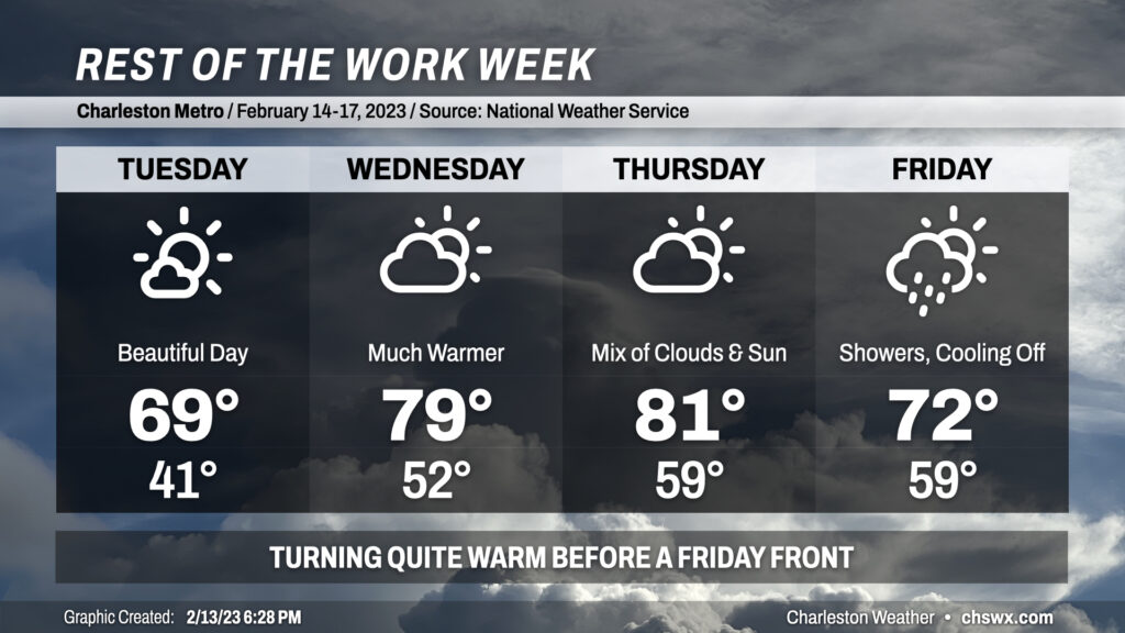
Mother Nature’s Valentine’s Day gift to Charleston is beautiful weather as high pressure remains in control. We’ll start Tuesday in the low 40s before temperatures rebound to around 70° under mostly sunny skies. Dewpoints will run in the low-to-mid-40s, yielding comfortable relative humidity values — overall, should be a nice day to enjoy some lunch outdoors. The only fly in the ointment may be the winds shifting to the south around 10-15 MPH at times. Other than that, though, no cold shoulder this year.
We turn much warmer Wednesday into Thursday as southerly winds continue ahead of a cold front which arrives Friday. Temperatures will jump to around 80° on Wednesday and could exceed 80° on Thursday despite increasing cloud cover. While we could get within striking distance of Wednesday’s record high of 82° set in 1989, we’ll be a far cry from Thursday’s daily record which is 87°, also set in 1989.
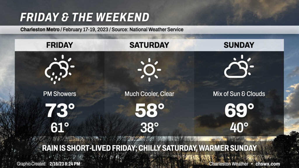
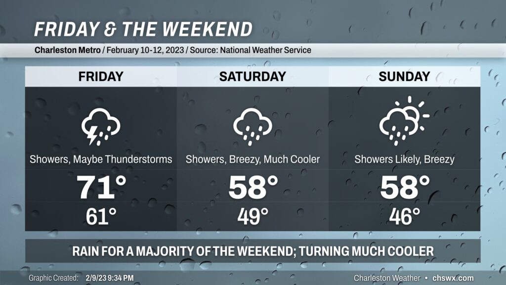
A cold front and associated band of showers moves through the area on Friday, limiting highs to the low 70s early in the day and cooling us off pretty quickly in the evening. The good news is that this rain won’t linger — the sun will be back out on Saturday, and a rain-free (albeit much cooler) weekend is expected.
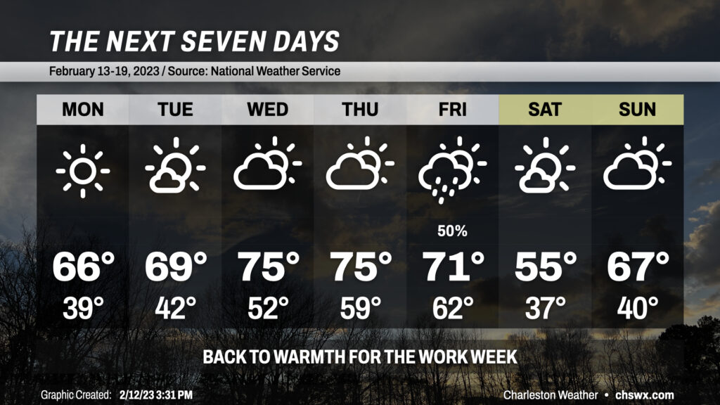
As has been true of the pattern for much of 2023 thus far, rain will have long since departed by Monday, which should end up being a rather beautiful day after starting in the upper 30s. Few, if any, clouds are expected as high pressure builds in; highs top out in the mid-60s. Another similarly beautiful, if not slightly warmer, day is on tap for Tuesday as highs approach 70° in the afternoon — really hard to ask much more for Valentine’s Day.
70s return in full force by Wednesday as high pressure moves offshore and winds go back to the south. We’ll see this accompanied by an increase in cloud cover through Thursday ahead of another cold front. Rain returns Friday, but shouldn’t be quite as much as we saw with this past weekend’s storm system, nor will it hang around as long. Cooler high pressure returns for the weekend, with highs in the mid-50s for Saturday but rebounding quickly into the the upper 60s for Sunday. At least it won’t be raining — feels like forever since we had a rain-free weekend!
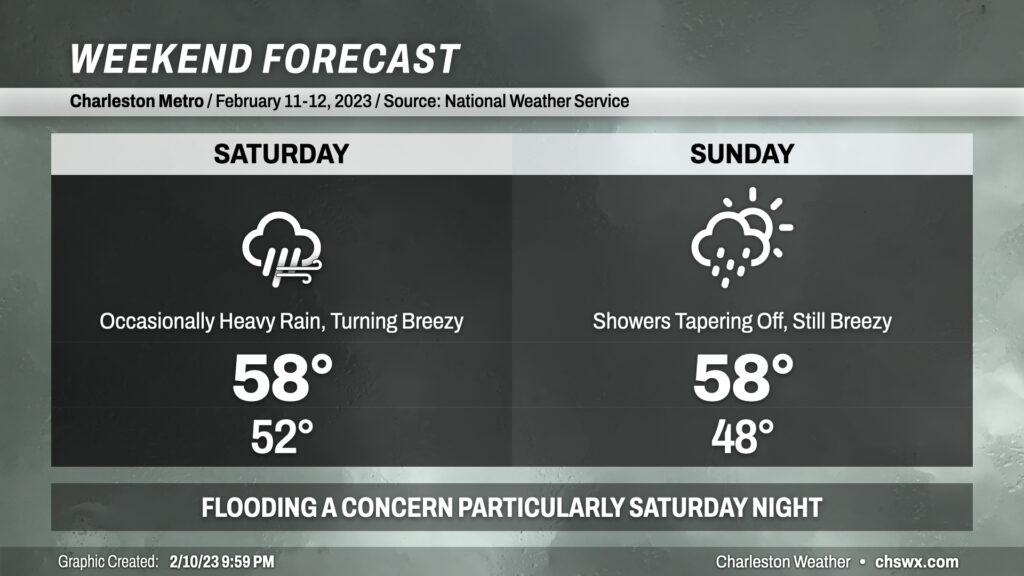
The weather takes a turn for the unsettled starting tomorrow as a cold front approaches the area from the west. We get one more day in the 70s ahead of this front, but plenty of showers are expected within a solid moisture feed from the Gulf, with the better rain chances arriving in the afternoon. A few thunderstorms can’t be ruled out if instability can materialize particularly later in the afternoon and into the evening, and the wind fields are such that a few stronger storms are possible.
A deep trough coming along with the front will slow down and cut off into an upper low. This is going to help keep the weather quite unsettled into the weekend, particularly Saturday as low pressure develops off the coast. Temperatures will drop into the 50s on Saturday and won’t rise terribly much as the upper low pivots overhead and showers stay in the picture. We stay quite chilly on Sunday as low pressure begins to move northeast, and showers will remain likely for much of the day. Highs top out in the upper 50s.
All in all, this is a weekend best experienced indoors. At least there’s going to be a reasonably super football game on Sunday.