Jared Smith founded @chswx on Twitter in 2008 as an experiment in disseminating weather data through social media. In the ensuing decade-and-a-half, @chswx has provided live coverage of tropical cyclones, tornadoes, severe weather, and even a couple bouts of winter weather to the good people of Charleston, SC.
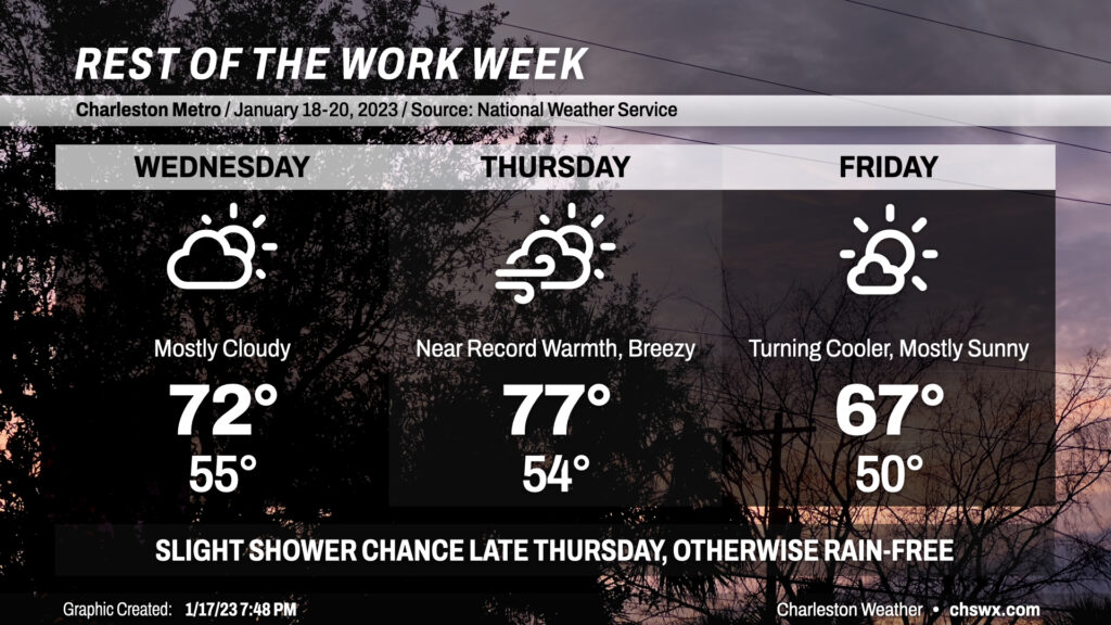
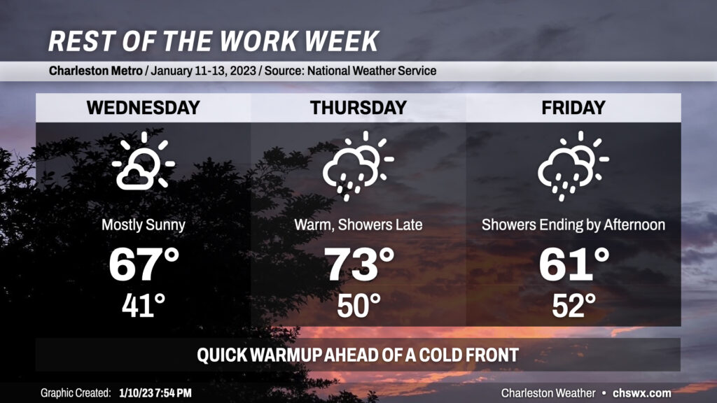
Temperatures look to stay well on the warm side of normal heading into the weekend, especially Wednesday and Thursday before a front late Thursday brings temperatures back down a little bit.
The rest of the work week will be punctuated with a warming trend through Thursday before a cold front knocks temperatures down slightly for Friday. There will be a few shower chances, but mostly after dark.
We have another round of subfreezing lows ahead for tonight, with clear skies and calm winds allowing temperatures to fall to the low 30s to start the day away from the warmer coastline. It won’t be a terribly long-duration freeze, but regardless, make sure pets are in and plants are covered again tonight.
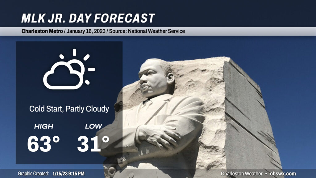
After that chilly start on Monday, we’ll see temperatures head into the low 60s in the afternoon as shortwave ridging aloft and more southerly winds kick in. We’ll see an increase in high clouds as the day goes on, but overall, expect plenty of sunshine for any outdoor Martin Luther King, Jr. commemorations.
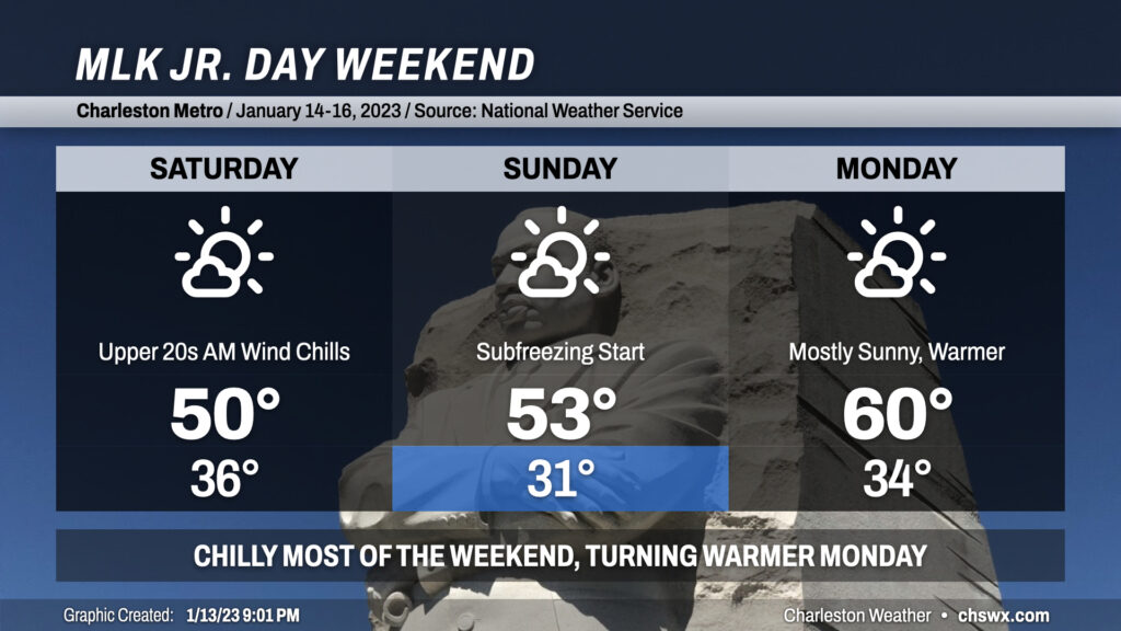
The weather turns quieter but much cooler this weekend as we get the first real taste of January weather almost mid-way through the month. After showers depart overnight, clouds will break up and temperatures will bottom out generally in the mid-30s; northwest winds 10-15 MPH will make it feel closer to the upper 20s. Despite clearing skies, the high will struggle to about 50° on Saturday with breezy northwest winds ongoing.
Winds slacken some, but not completely, Saturday evening into Sunday. We should see freezing temperatures in the metro for at least a few hours Sunday morning as lows drop to around 30-31°. The continued cool advection from the northwest will help bring these colder temperatures to the coast, though we should stay just above freezing there. This isn’t a December 2022 freeze by any stretch, but be sure to have your pets inside and loved ones accounted for. A little ridging begins to nose in aloft, which will allow highs to head a little more north of 50° than we will see on Saturday.
Monday will start in the mid-30s once again, with calm to light winds expected, taking the bite off the wind chill. Continued mostly sunny skies will allow the high to reach up around 60°, making for fairly nice conditions for outdoors Martin Luther King, Jr. commemorations.
Showers and maybe a thunderstorm will be accompanying a cold front tonight into tomorrow morning. There could be some brief pockets of heavy rain and gusty winds, but no severe weather is expected.
The front will get through around daybreak or so Friday morning. Persistent cloud cover and cold air moving in will limit highs to the low 60s. Showers become possible once again later into the evening hours as low pressure develops to our northeast; any rain, if it does end up falling, should be relatively light.
As low pressure departs, skies will clear and temperatures will tumble. Expect to wake up to mid-30s on Saturday morning, with highs struggling to 50° in the afternoon despite full sunshine. Subfreezing temperatures are expected Sunday morning, with a few spots well inland perhaps dipping into the upper 20s. Full sunshine and some shortwave ridging aloft will help temperatures start to rebound a little in the afternoon, with highs in the mid-50s expected. We’ll return to the low 60s for Monday, and will be back in the 70s by Wednesday, so this cold spell won’t have much staying power — good news for warm weather fans, and not so much fun for the cool-inclined amongst us. But so it goes in the “cool season” during a La Niña year here in the Lowcountry.
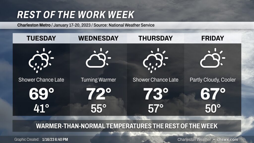
The rest of the work week will feature a quick warmup (with a brief return to the 70s on Thursday) before a cold front brings temperatures back down to earth for Friday and the weekend.
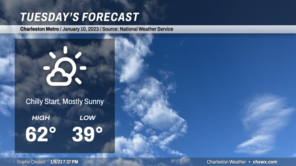
Tuesday will start a little cooler as light winds and a decent period of clear skies should allow lows to drop into the upper 30s. High pressure will continue to exert itself across the area during the day, with highs heading into the low 60s under mostly sunny skies. Otherwise, there’s not much to write home about weather-wise: We stay with fair weather through Wednesday, and our next rain chance arrives late Thursday before a cold front cools us off for what will otherwise be a quiet weekend of weather.
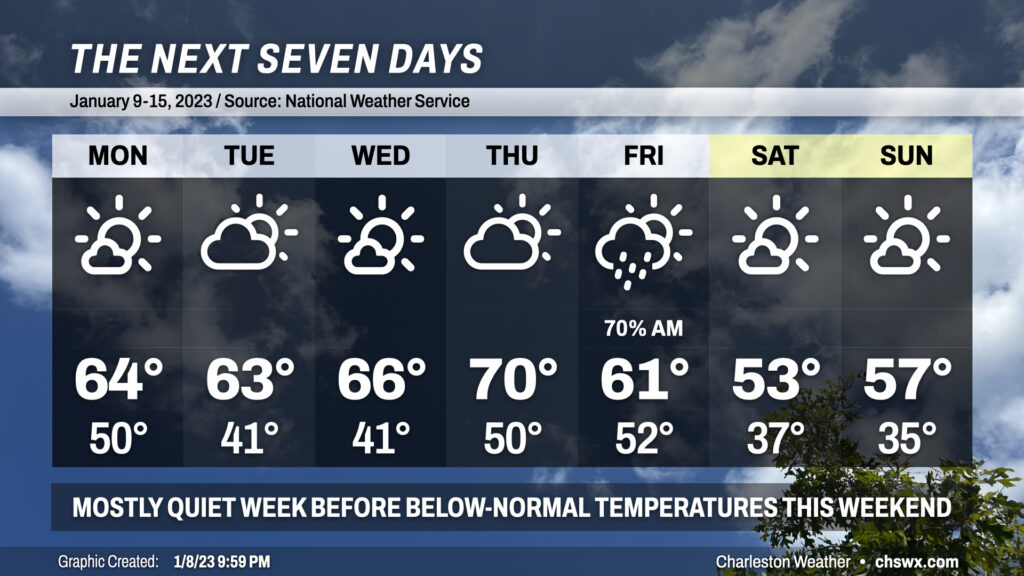
We’ve got a pretty quiet week of weather ahead aside from a frontal passage overnight Thursday into early Friday morning, which should spread some showers and maybe a thunderstorm through the area. Highs for much of the work week will run in the mid-60s, with temperatures approaching 70° on Thursday. Lows on Monday will bottom out around 50°, with a couple chillier mornings ahead for Tuesday and Wednesday with lows in the low 40s before warming back to 50° for Thursday and Friday morning.
The best chance of rain arrives late Thursday night into Friday morning, with showers expected. A thunderstorm or two can’t be ruled out ahead of the front, either, but timing will generally be a little less favorable climatology-wise for thunderstorms. Rain comes to an end Friday morning, and the cold front will be clearing the area during the day. Cooler and drier air filtering into the area will limit highs to the low 60s in the afternoon. Saturday will be as chilly of a start as we’ve seen since the turn of the year with lows in the mid-30s. Highs on Saturday will struggle to the low-to-mid-50s, while Sunday will run a little warmer with highs in the mid-50s after starting solidly in the mid-30s. Overall, though, not too shabby for the first full work week of 2023.
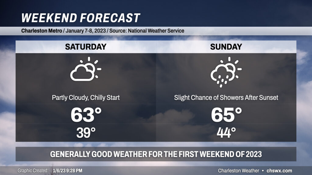
The first weekend of 2023 is here, and the weather overall looks pretty good across the area, particularly Saturday. Morning cloud cover and lows in the upper 30s will give way to more sunshine and highs in the low-to-mid-60s, still above normal for this point in the year. Sunday will feature more in the way of cloud cover throughout the day as some energy aloft approaches from the west. Despite the cloud cover, expect highs to still reach into the mid-60s in the afternoon. The aforementioned energy could lead toward some isolated to scattered showers breaking out after sunset Sunday into early Monday. Significant rainfall is not expected, though. All in all, not a bad weekend to get out and about!
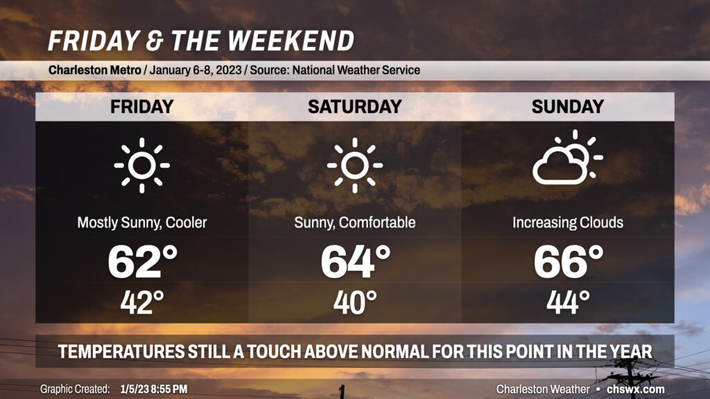
Friday and the weekend will feature quiet and comfortable weather for early January as cooler and drier air behind a cold front continues to filter in. Temperatures will still be running a click or two above normal, with highs in the low-to-mid-60s each day and lows generally in the low-to-mid-40s. Sunday looks to be the warmest of the three days as another cold front draws closer to the area, which could bring some rain chances late into Monday. Overall, our mild start to 2023 largely continues, and that ain’t bad.