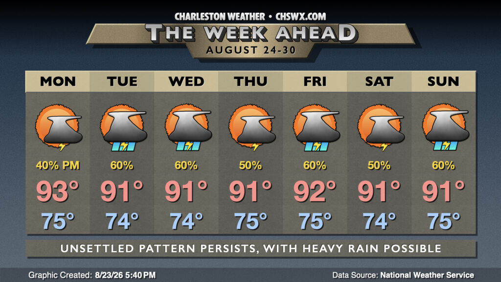
The hot pattern we have been stuck in for the better part of a week and a half finally begins to break down starting Friday, helping to temper some of the extreme heat that we’ve experienced while also allowing for more showers and thunderstorms, particularly Friday and Saturday.
Another hot day lies ahead on Thursday, but we do have some changes coming that will turn conditions a little more unsettled, which in turn will start to take the edge off this heat some.
That being said, Thursday will mark the ninth consecutive day of heat headlines of some sort, whether it be a Heat Advisory or an Extreme Heat Warning, and it’s getting very difficult to find new ways to tell you it’s going to be hot. We start Thursday in the upper 70s to low 80s once again, with air temperatures in the afternoon peaking in the mid-90s. Heat indices will once again peak between 108-112° — not as bad as it has been, but still pretty gnarly — and that’s prompted the aforementioned heat advisory for Charleston and Berkeley counties. (Looks like we’ll fall short of heat advisory criteria in Dorchester County, but it will still be quite hot to the point where you’ll want to monitor for heat illness if outdoors for an extended period.) A few of us should see some isolated to scattered thunderstorms in the afternoon along and ahead of the seabreeze. There’s not much shear and storm motions will be slow, so heavy rain will continue to be a concern, and with plenty of instability available, storms could produce frequent lightning and gusty winds in downbursts. Be ready for conditions to change on a dime if out and about.
After reaching 99° again on Tuesday, we will start to see a a slow down-trend — though not necessarily an end — to the heat wave as we get through the second half of the work week and head toward the weekend.
Another extremely hot day is on tap for Tuesday as temperatures take what should be one last shot at the 100° mark before sanity begins a slow return to the forecast. We’ll start the day near 80° inland of the coast, and we’re almost assuredly not getting below 80° at the coast and in downtown Charleston. From there, temperatures will soar into the upper 90s to near 100°, with the best risk of reaching the 100° mark inland of Highway 17. And then there are the dewpoints running in the mid-to-upper 70s, which will propel heat indices well into the mid-110s for many of us, with a few readings getting uncomfortably close to 120° in more rural spots. For the first time in this heat wave, an Extreme Heat Warning is in effect for the entire Tri-County, including Dorchester; to this point, we’ve only seen those warnings come out for Berkeley and Charleston. Continue to heed precautions for extreme heat: air conditioning if at all possible, but frequent breaks in the shade with water if you must be outdoors.
There will be a slightly better chance of thunderstorms Tuesday afternoon than we saw on Monday, which will cool some of us off. The price for this, though, is an elevated risk for strong and potentially damaging wind gusts, excessive lightning, and very heavy — perhaps flooding — rain in a few spots. Instability will be running on the high end of what we usually see around these parts, so any storm that can take advantage could take off like a rocket. The good news is that without much shear, storms will generally pop, rain for a while, and then collapse.