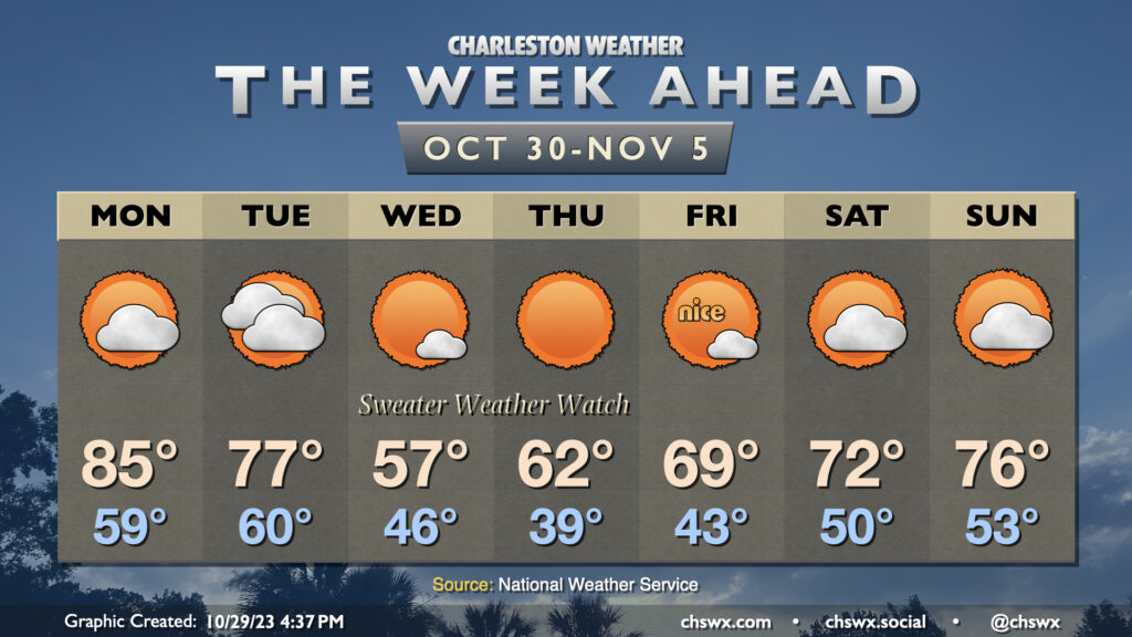
The week ahead will feature the strongest cold snap of the season thus far sandwiched between a warm start and a warm finish. It’s a classic “shorts then sweaters” week of fall weather in the Lowcountry as a strong front moves by late on Halloween.
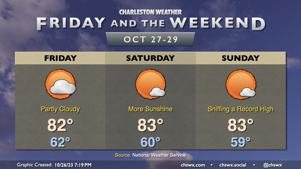
This will be an unseasonably warm final weekend of October across the Lowcountry as temperatures will bear more resemblance to mid-May. Expect highs in the mid-80s each afternoon with lows around 60° to start each day. Sunday’s forecast high of 85° would, if it came to pass, tie the record high for October 29 set in 1946. We’ll do this courtesy of stacked high pressure remaining in control for a few more days; dry air aloft will keep cloud cover at a minimum, and it’ll be a good weekend for sunshine overall.
No good weather deed goes unpunished, though: There will be a high risk of rip currents at the beaches in case you are wanting to wade into the water, and morning high tides will be high enough to cause some minor salt water flooding as well. Keep an ear out for Coastal Flood Advisories from the National Weather Service.
A strong front coming by around Halloween will flip the script on temperatures. We’ll go from 83° on Monday to 77° on Tuesday before highs only top out around 60° on Wednesday and Thursday. It’s probably safe at this point to go ahead with a Sweater Weather Watch for next week!
Warm weather continues for Friday and the weekend, feeling a lot more like September than late October. Temperatures will continue to run in the low 80s each afternoon after starts in the low 60s each day. Unsurprisingly, these temperatures run well above climatology. At this point in October, a normal day starts in the low 50s, and we will run well above that through the end of the month, it looks like. Our high temperatures will come in about 8-9° or so above normal each day; we should be in the mid-70s. While the record highs for Friday and Saturday seem out of reach (87° and 86°, respectively), Sunday’s forecast high of 83° comes within a couple degrees of the daily record high of 85° set in 1946.
Fall fans, do not fret, though: A strong cold front appears timed for Halloween. This front will knock temperatures back to near normal for Tuesday, followed by below-normal high temperatures as we start November (think mid-60s vs. mid-70s).
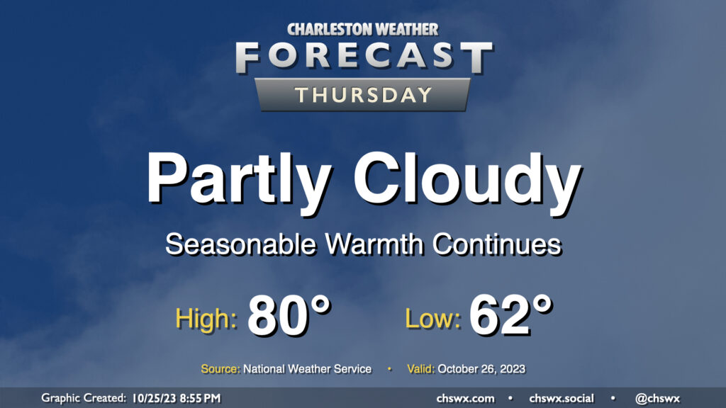
Rinse and repeat: More quiet and warm weather is on tap for Thursday (and beyond!) High pressure remains in control, and that’ll keep things rain-free and rather warm for late October. We start the day in the low 60s (for reference, the normal low for October 26 is 54°) and warm to around 80° in the afternoon. Much like Wednesday, we’ll see a few clouds amongst otherwise blue skies.
The only fly in the ointment will be the potential for some minor coastal flooding with the Thursday evening high tide. Water levels should peak between 7-7.2′ in the harbor, and this’ll cause some salt water to spill onto the typical trouble spots roughly an hour or two on either side of the 6:49 PM high tide. We’ll probably land a Coastal Flood Advisory during Thursday evening’s commute, so be ready to route around a little salt water especially around the Citadel and MUSC.
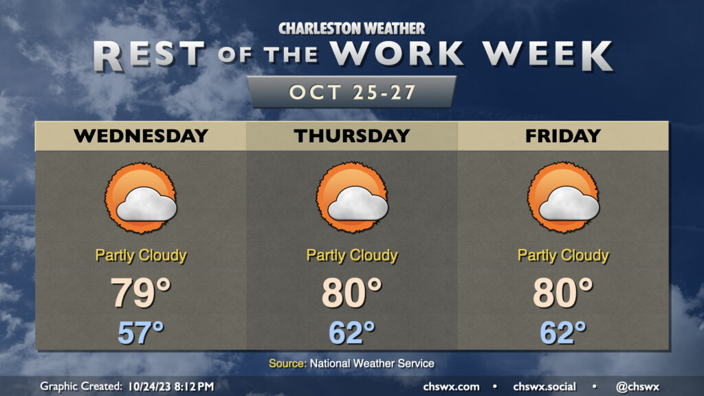
The rest of the work week will be seasonably warm as high pressure remains in firm control of our weather. We’ll start Wednesday noticeably warmer than Tuesday with lows in the upper 50s as opposed to the upper 40s. From there, temperatures will warm to near 80° under partly cloudy to mostly sunny skies. We start Thursday even warmer, with low 60s forecast — several degrees above normal for this point in the year. Temperatures top out around 80° with a mix of sun and clouds. As for Friday, copy and paste — pretty much the same story as Thursday. We keep warmth heading into the weekend and to start next week, though we should see a cooldown in time for Halloween.
High tides on Wednesday will get close to coastal flood criteria and could yet require a Coastal Flood Advisory or two if the departures tick up just a little more. We’ll flirt with minor coastal flood criteria at times of high tide into the weekend, so keep an ear out for possible Coastal Flood Advisories from the National Weather Service.
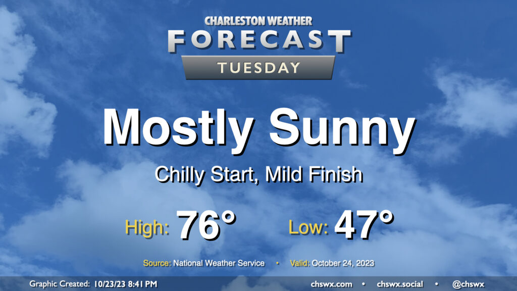
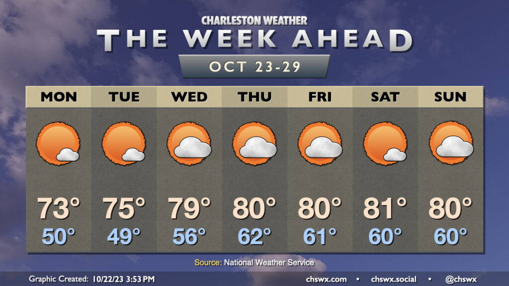
We get off to a fairly chilly start on Tuesday as lows bottom out in the upper 40s thanks to clear skies and light winds. This will be the low-water mark (so to speak) for temperatures, though, as we head into the rest of the week. Highs on Tuesday top out in the mid-70s once again, perhaps a degree or two warmer than we saw on Monday. All in all, another nice October day.
The story of this week’s weather will be high pressure keeping a firm grasp on the area for the rest of the week (and maybe even the rest of October). This will lead to generally quiet weather, with a warming trend bringing us into the low 80s starting around midweek. Monday will be the coolest of the set in the wake of a dry cold frontal passage; we start the day around 50° and warm into the low 70s in the afternoon with just a few clouds. Tuesday starts a touch cooler, but the warming trend will begin with temperatures reaching a little warmer in the afternoon. A decent stretch of above-normal warmth takes hold from there, with variable cloud cover but little else to write home about as moisture is generally scant. All in all, it’s not a bad week to get the car washed (note to self) and enjoy some outdoor lunches.
The only concern may end up being coastal flooding at times of high tide possibly starting as early as Tuesday. Winds will be out of the northeast as high pressure settles in to our northwest, and this combined with the upcoming full moon will once again start to send water levels above coastal flood criteria as we head into the latter half of the week. Keep an ear out for Coastal Flood Advisories from the National Weather Service.