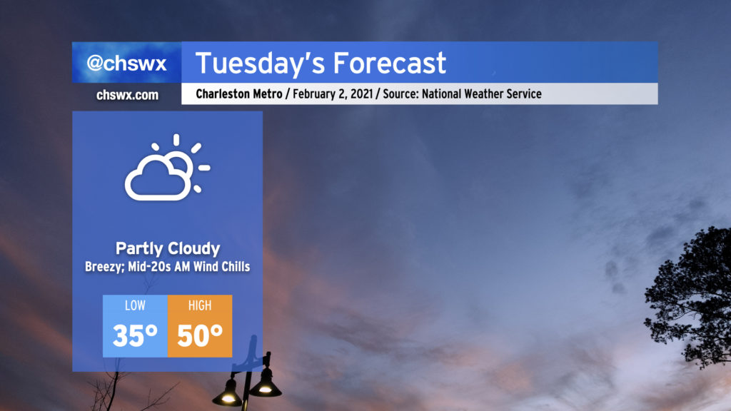
Cooler and drier air will rush into the area tonight into Tuesday, helping to break up the cloud cover but keeping us rather chilly. Breezy northwest winds will make tomorrow morning’s mid-30s feel more like the 20s, so if you’re headed out in the morning, make sure you’ve got a little layering going on to stay warm. Despite some downslope flow, highs will struggle to reach 50° in the afternoon with periods of cloud cover. (At least it won’t be raining.)
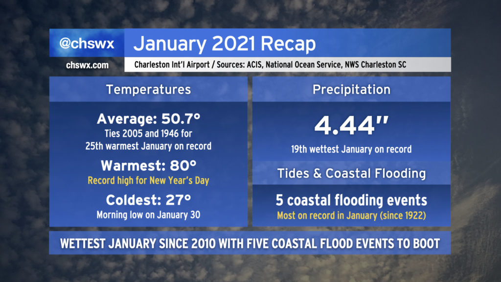
January 2021 has come to an end. It was an interesting month in many ways, but as far as weather goes, the month was on the warm and wet side of what passes for normal around here, but wasn’t too out of bounds.
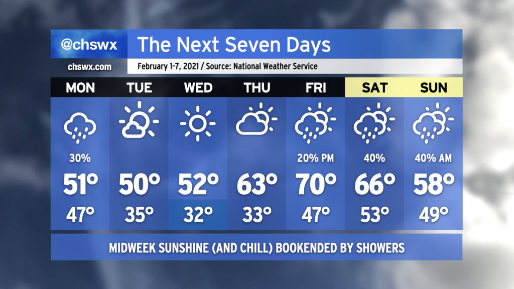
We will begin February much as we spent about half of January: Chilly, cloudy, with occasional showers in the area. Fortunately, showers will depart for mid-week, as chilly high pressure runs the show through Thursday. Watch for some frosty and freezing temperatures mid-week before a warming trend commences Thursday afternoon. By Friday, we’re scraping 70° again as we return to the warm sector ahead of our next storm system, with showers becoming possible late in the day. Timing of our next front is somewhat suspect, so you’ll want to keep an eye on the forecasts for the weekend in anticipation of adjustments to rain chances and temperatures.
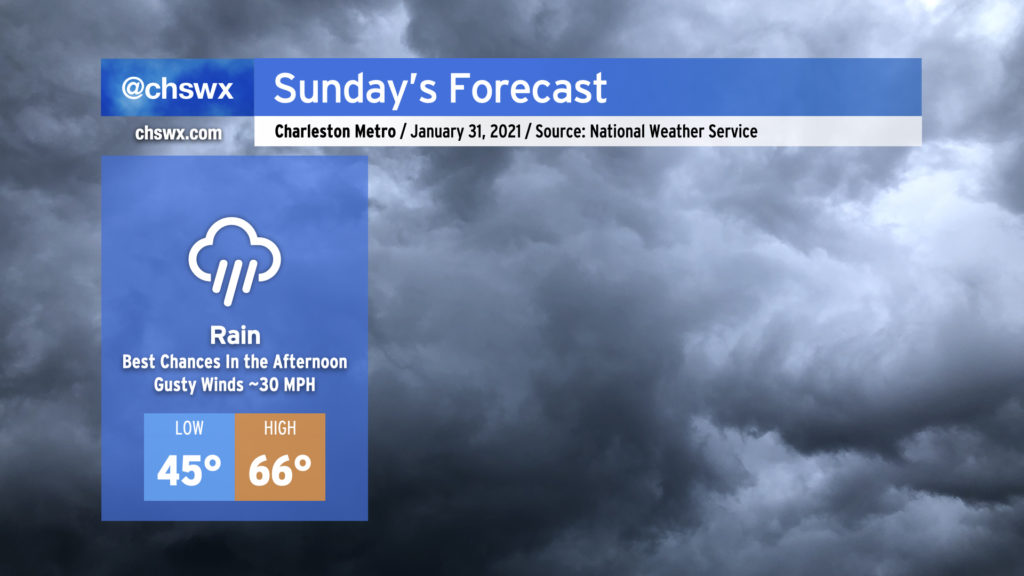
Cloud cover has arrived, and the rain will pick up as Sunday goes on as yet another cold front makes its way toward our neck of the woods. The best chances of the heaviest rain will come later in the afternoon into the evening hours, but showers will be possible at really any point of the day. Once it’s all said and done, we could log another half-inch to inch of rain in the books to close out January.
Temperatures will run in the mid-60s with a stiff southerly wind pumping warm, moist air into the region. Gusts could reach 30 MPH at times, particularly on exposed overpasses and bridges, so be cautious when traveling tomorrow.
There will be a small risk of some minor coastal flooding with tomorrow morning’s high tide, which would primarily affect areas near The Citadel and around Lockwood Dr. High tide is forecast to peak a little after 9:30am.
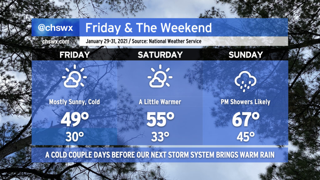
Chilly high pressure will continue to build into the area tonight into Friday, bringing freezing temperatures very close to the coast to start the last day of the work week. Temperatures will struggle to reach 50° despite full sunshine. Expect mostly sunny skies to prevail through Saturday as temperatures moderate back into the mid-50s in the afternoon. Our next storm system begins to affect the area possibly as early as late Saturday night, with rain likely on Sunday. Can’t rule out a few rumbles of thunder, either. It’ll be noticeably warmer — highs in the mid-60s will be common Sunday in the warm sector of the storm system before it moves through late Sunday into early Monday.
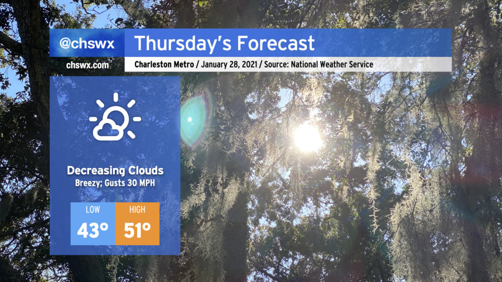
A cold front will swing through overnight, bringing much cooler and drier air to the Lowcountry for the next few days. Wind gusts 30-35 MPH could be common overnight into Thursday morning, with higher gusts possible on bridges and overpasses. Be careful during your morning commute.
Skies should clear out by midday, but despite plenty of sunshine, temperatures will struggle to the low 50s as cold air pumps into the area. But, hey, the sun will come out, and that’s better than we can say for the last few days.