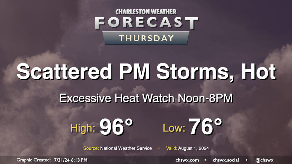
Heat will be the main weather story on Thursday as air temperatures reach into the mid-90s and dewpoints peak in the mid-70s, combining for heat indices that could approach 110-115° in the afternoon. This has prompted an Excessive Heat Watch from noon-8PM, when heat indices could be highest. If the forecast indicates heat indices approaching or exceeding 113°, this could be upgraded to an Excessive Heat Warning; otherwise, a Heat Advisory would likely be the move barring an unexpected cooler start (like we saw today, in fact!)
Showers and thunderstorms will be possible in the afternoon and evening hours as the seabreeze pushes inland. We could also see storms coming our way from the Midlands once again as well. Widespread severe weather is not expected, but you can never rule out a damaging wind gust or two this time of year.
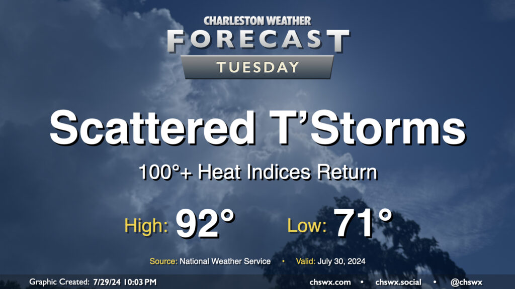
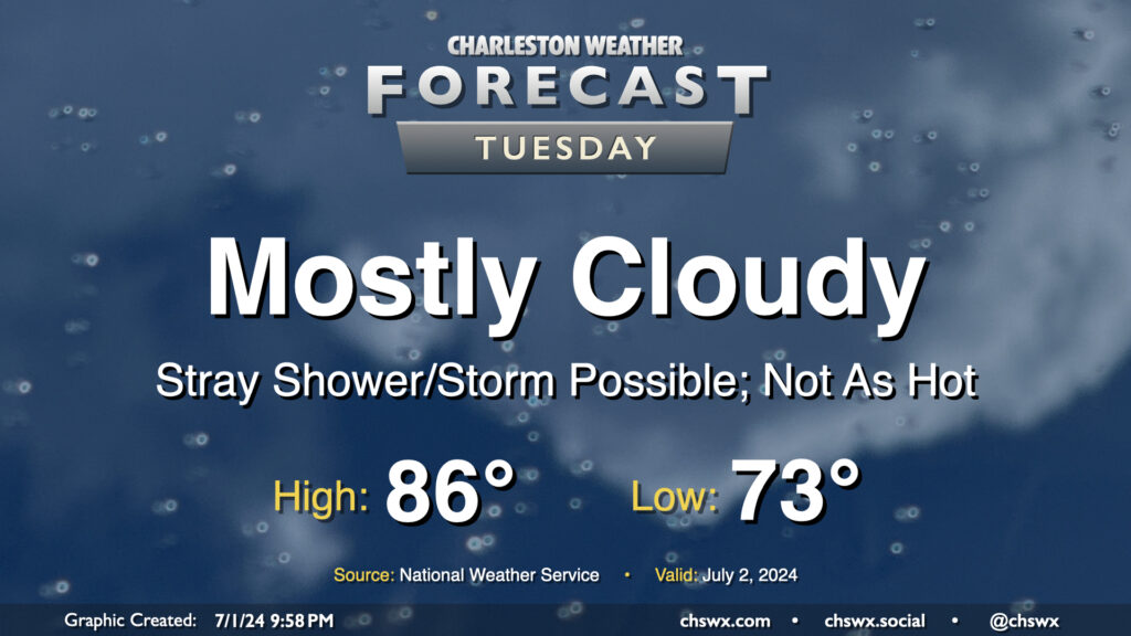
Well, the respite is decidedly over: we’re back to 100°+ heat indices on Tuesday as surface high pressure shifts offshore and higher-dewpoint air returns to the area. We start the day in the low 70s one more time, but will warm quickly into the 80s by mid-morning and should be back in the 90s by early afternoon. Dewpoints look to climb into the mid-70s throughout the day, and this will yield heat indices around 103° — hot to be sure, but shy of advisory criteria. Scattered showers and thunderstorms are primarily expected in the afternoon and evening hours, though a few showers can’t be ruled out in the morning. A few showers may try to get going on the seabreeze, but high-resolution guidance suggests that the bulk of any activity will get going perhaps in the Midlands and Upstate before dropping southeasterly into the metro. Some heavy rain is possible, and a damaging wind gust or two is not out of the question, either. Keep an ear out for possible warnings Tuesday evening, just in case.
More active weather is expected Thursday as a stalled front combines with a favorable upper-air configuration and plenty of available moisture for numerous showers and thunderstorms. While it won’t rain all day at any one location, be ready for downpours to affect your day. We could see showers and storms fire overnight near the coast, in fact, and those could impact the morning commute, while guidance continues to paint solid afternoon thunderstorm chances as well.
This at least helps drives temperatures down a touch: while the low of 77° is still quite balmy, highs top out in the low 90s at best with heat indices running lower than they have on previous days. (A meteorological Pyrrhic victory, perhaps, but so it goes in late July.)
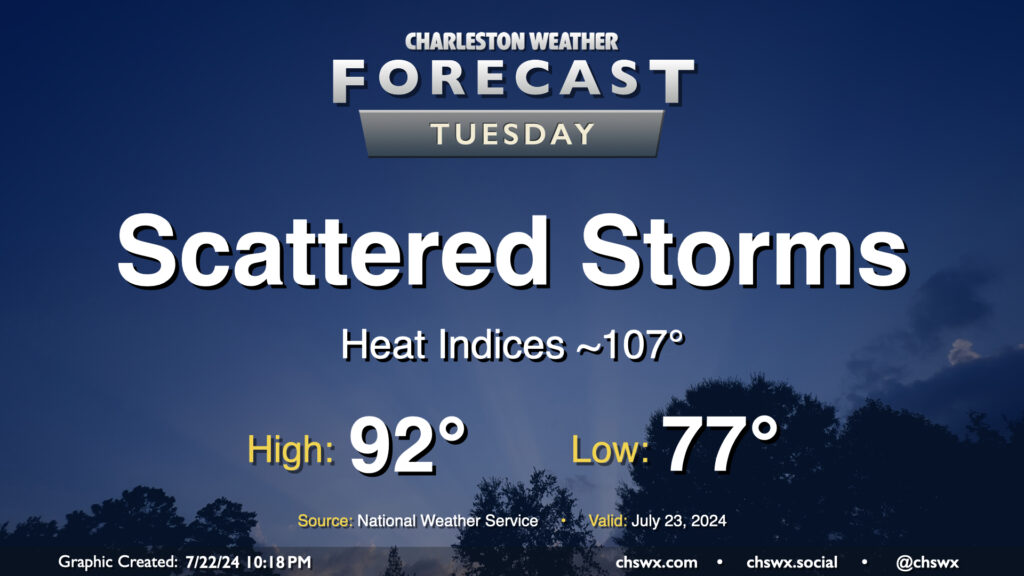
Heat and humidity will continue to rule the roost for Tuesday and for the next couple days as we stay within southerly flow at the surface and aloft, keeping the moisture pump moving right along. This will also lead to periods of storms. Guidance is hinting at another round of morning showers and storms near the coast as the land breeze develops before afternoon storms develop further inland. Coverage will generally be scattered in nature, and not all of us will see rain as a result. Highs top out in the low 90s after a start in the upper 70s; expect heat indices to get close to advisory criteria in the afternoon, perhaps approaching 107°.
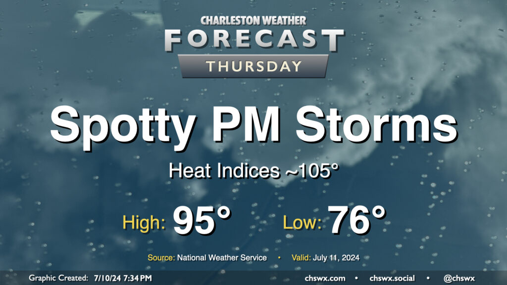
A stalling front will briefly usher in slightly drier air on Thursday, helping to keep heat indices below heat advisory levels, but it’ll still be plenty warm with air temperatures peaking in the mid-90s and heat indices in the mid-100s expected. We should still see a few showers and thunderstorms pop in the afternoon, but like Wednesday, coverage should be reasonably limited.
Scattered showers and thunderstorms will stay in the forecast for much of the day Tuesday. While it won’t rain all day at any one location, a shower or storm will be possible pretty much anytime especially beyond 10am. Locally heavy rainfall will be possible, but severe weather is unlikely.
We start the day in the upper 70s to low 80s at the coast, warming to the low 90s in the afternoon. Dewpoints in the upper 70s yield heat indices in the mid-100s (though just shy of advisory criteria), which will continue this stretch of uncomfortably steamy weather.
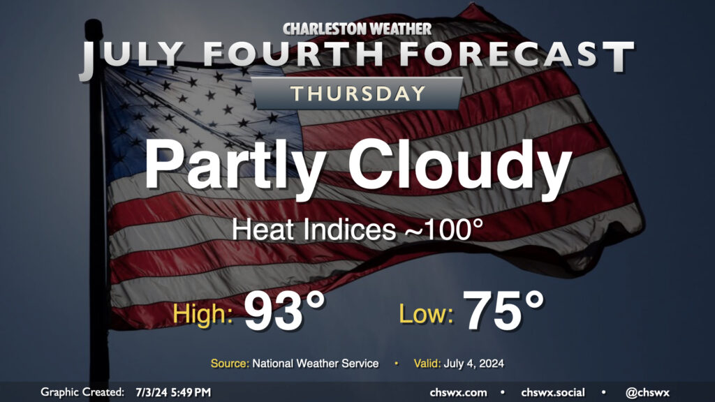
The Fourth of July should be a generally quiet weather day across the area, featuring partly cloudy skies and generally near-normal temperatures (read: still fairly hot). We start the day in the mid-70s and will warm to the low-to-mid-90s away from the coast, which looks to run more into the upper 80s to around 90°. The heat index will run around 100° as dewpoints remain a touch lower than they have been (generally low 70s). You’ll want the sunscreen with the UV index expected to run close to 10 at the height of the afternoon. Ridging aloft will keep a lid on any thunderstorm activity, removing Mother Nature’s fireworks from the equation this go-around.
We get a brief reprieve from the heat on Tuesday as the front that brought today’s deluge nudges just south enough for a little bit of cooler and drier air to work in, especially further inland. Mostly cloudy skies will be the rule as onshore flow persists throughout the day. We start the day in the low 70s, but dewpoints sneaking briefly back into the upper 60s could feel a little bit better than we’ve felt. Those dewpoints will start to creep back up, but the cloud cover and onshore flow keeps highs capped to the mid-80s. A stray storm can’t be totally ruled out near the coast; in fact some model data suggests a few downpours will be possible before sunrise. Wait and see on that, but most of us should get Tuesday in rain-free.
It was a nice couple days of heat indices “only” in the upper 90s to low 100s, but we return to Advisory-level heat on Sunday as air temperatures in the mid-90s combine with dewpoints in the mid-to-upper 70s to yield heat indices 108-110°. Once again, you’ll want to be sure your outdoor activities involve frequent breaks in the shade with plenty of water.
Those outdoor activities may become disrupted as we get into the afternoon and evening hours as thunderstorms begin to fire along and ahead of the seabreeze. Coverage should increase as the evening goes on as a disturbance aloft swings by. Scattered to numerous showers and thunderstorms will be possible with some periods of locally heavy rain and cloud-to-ground lightning. A few stronger storms could produce sporadic damaging wind gusts, so be alert for possible severe weather warnings as well. Regardless of the severity of the storms, lightning makes every thunderstorm dangerous. If you can hear thunder, you’re close enough to be struck by lightning, so move those outdoor activities inside if a thunderstorm approaches your location. Most of the activity should disperse as we get later into Sunday night, though some could hang around with the energy aloft and an approaching front.
We’ll want to keep an eye on Monday for the potential for some flooding as slow-moving showers and storms should fire on that aforementioned front as it stalls out across the area. I’ll have more on that risk tomorrow as more data rolls in.
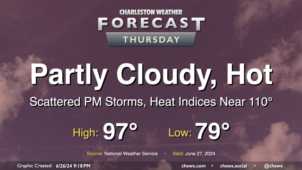
The meteorological status quo continues on Thursday: Heat, humidity, and a few storms in the afternoon. Temperatures will be fairly heinous on Thursday, with lows barely dipping below 80° away from the warmer coastline and highs getting into the mid-to-upper 90s in the afternoon. Mix in dewpoints in the mid-70s, and that’ll yield another day of dangerous heat indices in the 107-110° range. I’d be ready for yet another Heat Advisory to be issued for tomorrow.
A front sinking southward into the area combined with the usual seabreeze influence will help improve shower and thunderstorm chances for more of us tomorrow afternoon and evening. Pockets of heavy rain will be possible, and some gusty winds will be possible in any thunderstorm as well. A stray Severe Thunderstorm Warning certainly is in the cards, but widespread severe weather isn’t expected.