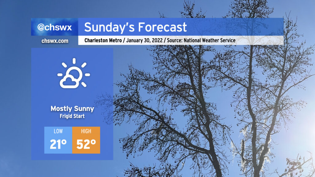
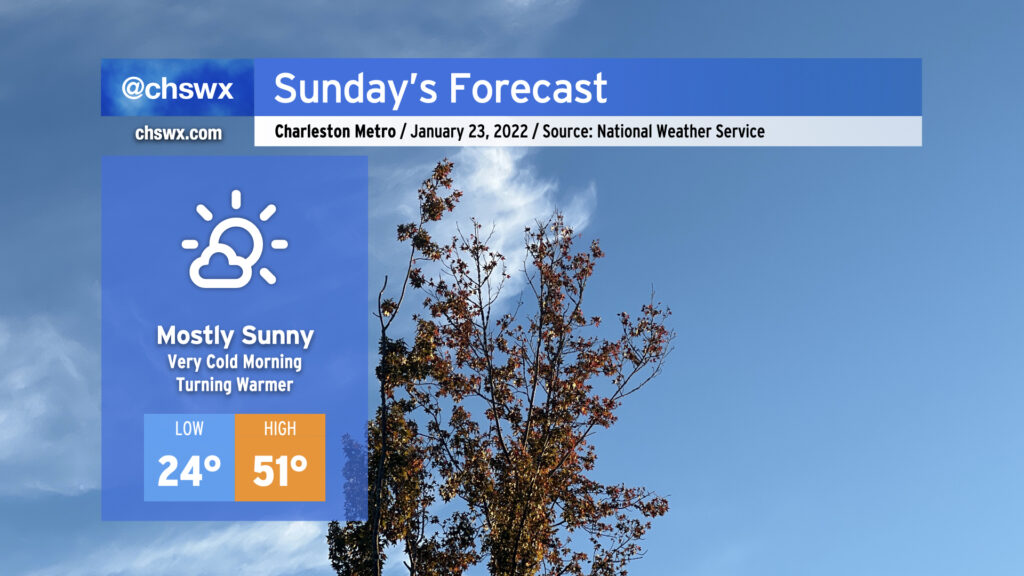
Sunday morning will be the coldest of the season thus far as lows bottom out in the low 20s in the metro area. I wouldn’t be surprised to see a few spots dip below 20°, even. Suffice to say, this is pipe-busting cold — keep a faucet on drip and make sure your pets and plants are in a warm place tonight. Add on some wind kicking in after sunrise, and temperatures could feel closer to the mid-teens during the morning.
A warming trend will commence, though, as winds go southwesterly during the day Sunday. Temperatures will top out in the low 50s (as opposed to the mid-40s) in the afternoon. We won’t fall below freezing overnight in most locations in the metro area (staying in the mid-30s) as we head into Monday morning, either. From there, Monday could be the warmest afternoon in a week and a half as highs climb into the low 60s for the first time since it was 73° on January 20. We could even see 70s again on Thursday ahead of our next storm system which, thankfully, looks to stay all liquid this go-around.
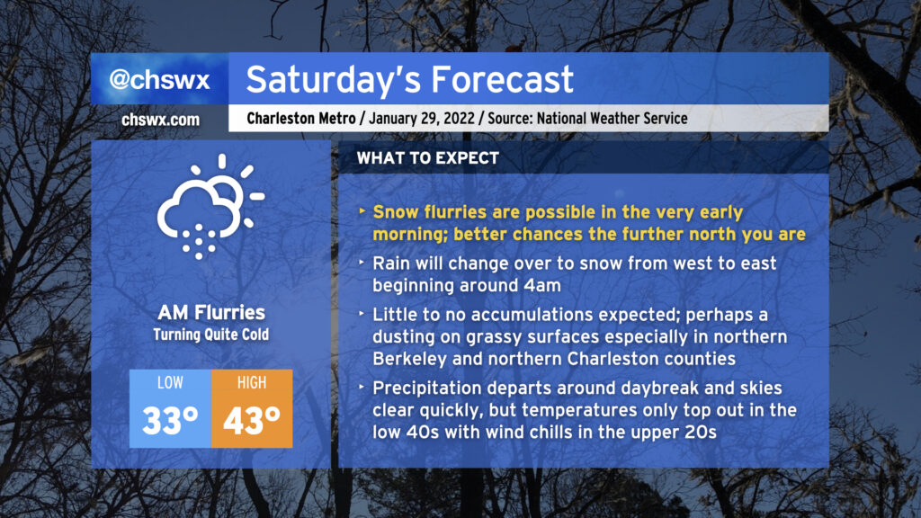
No point in burying the lede: Yes, we do have a legitimate shot at some light snow very early on Saturday morning. If you’re looking for your best chance to see snow, you’ll need to get up pretty early — general thinking around timing the change from rain to snow is generally from 3-5am from west to east.
There’s inherent uncertainty in where flakes will fly. We’re likely to see our best snow in northeastern Berkeley County and far northern Charleston County, where a couple hundredths of an inch could accumulate primarily on elevated and/or grassy surfaces. Further south into the Charleston metro area, precipitation looks to lighten up and taper off as moisture is stripped out of the atmosphere. It’s here where my confidence in whether we even see flurries is lower — a lot will be determined by the path of the upper low over the next few hours. In all cases, though, it is unlikely that we will see any problems.
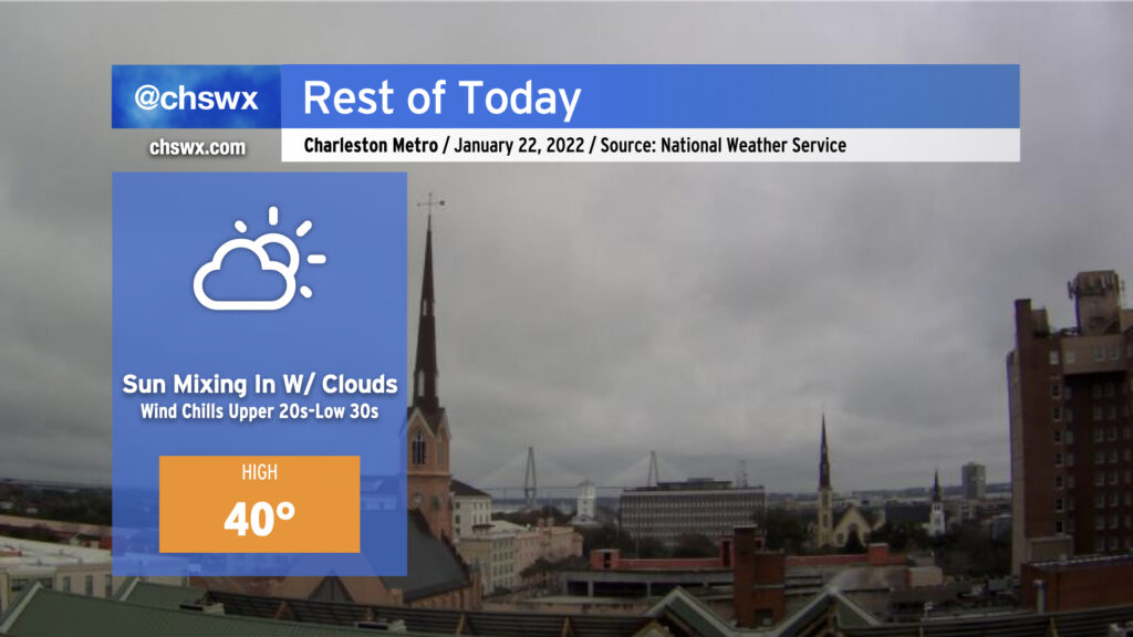
Precipitation looks to depart generally around daybreak, though the further north you are, the longer it might linger as light snow. Once the snow is gone, attention turns to the surge of Arctic air in the wake of the strengthening coastal low pressure that is going to bring a blizzard to a fair number of people in New England. Highs will only top out in the low 40s, and it’s conceivable that wind chills could be in the 20s well into the afternoon. Air temperatures get that low for Sunday morning as another cold day is on tap before a warming trend evolves beginning Monday.
Let me know what you’re seeing tonight into tomorrow morning if you end up trying to wake up early for this — just make sure you’re bundled up!
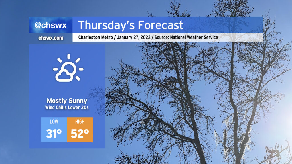
Thursday will start below freezing as cold air continues to push into the area from the northeast. Temperatures generally look to range between the upper 20s well inland to around freezing in the North Charleston area to the mid-to-upper 30s closer to the coast. Factor in the wind, though, and it may feel like the low 20s in spots. Make sure everyone’s bundled up well heading to work or school. Afternoon temperatures top out in the low 50s despite the plentiful sunshine.
As we get into Friday, we’ll be watching the development of a low pressure system off the coast closely. Said low pressure will spread rain into the area on Friday before another shot of Arctic air arrives. There remains a possibility for some flurries or brief snow showers early Saturday morning. The closer the low is, the better shot we have at some wrap-around flurries. Generally speaking, though, cold chasing moisture can be a recipe for winter weather disappointment in the Carolinas, so be sure to set expectations accordingly. Most importantly, no accumulations are forecast, limiting travel impacts. (No freezing rain, either!)
The certain impact from this storm will be the aforementioned Arctic air being drawn southward behind it. We may not get out of the 40s from Friday night through Monday afternoon, with a particularly frigid morning on tap on Sunday with low 20s in the Charleston metro area and the potential for air temperatures in the teens further inland.
Stay tuned to forecast updates on our (thankfully much more conversational) winter weather chances overnight Friday into Saturday morning!
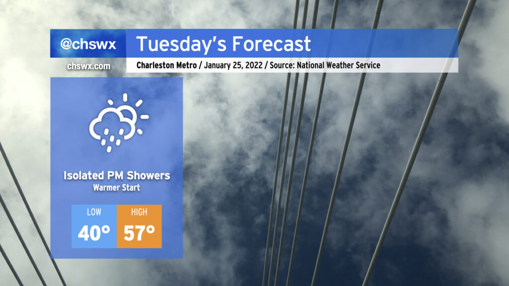
Low pressure moving along the Gulf Coast will keep a little more cloud cover in the area for Tuesday than we saw on this brilliantly sunny Monday. That will have the effect of keeping temperatures right around 40° to start the day, a touch warmer than we started with today and definitely warmer than how we started the weekend. Highs will rise back into the mid-to-upper 50s with winds coming out of the west. This is still cooler than normal for this point in January, but decent considering the expected broken cloud cover in place.
A shower or two will be possible in the afternoon and early evening hours mainly near the coastal areas as the aforementioned low pressure moves on by, but the vast majority of us look to stay rain-free. If it does rain, it may not even be measurable.
I’m also continuing to monitor model trends for scuttlebutt around a potential coastal storm this weekend. If you’re looking for another dose of winter weather, today’s trends aren’t ideal: model agreement has been improving in keeping the low pressure system in question well off our shores, with the GFS and ECMWF now in a bit more agreement on bringing drier air into the area before the colder air arrives. While the two models did a better job lining up today, I’m going to need to see a bit more run-to-run consistency overall before confidence in any one solution can improve.
For its part, NWS has a 40% chance of rain — and that’s it — for Friday afternoon into early Saturday morning, and if you need to be making any decisions about your weekend, that’s the forecast you want to be following. Stay tuned, for future adjustments to the forecast are more likely than not.
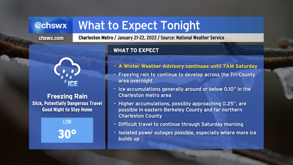
We’re headed into the coldest night of the season in the wake of last night’s winter weather. Temperatures will easily drop into the mid-20s and even lower — perhaps scraping the upper teens in the northern part of the Tri-County — which will be our first real bout with pipe-busting cold so far. Make sure you’ve got a faucet running on a drip and your pets have a warm place to be tonight. If you’re traveling, slick spots are not out of the question tonight into tomorrow, so please be careful on the roads.
After that frigid start, temperatures will warm into the low 50s for Sunday afternoon. Certainly chilly, but downright balmy when compared to today’s high of 38°. We’ll have plenty of sunshine to close out the weekend, and that should help finish the job on any remaining ice issues.
Cloud cover will continue to break up as the day goes on, and yes, most of you should see at least some periods of sunshine before the day is out. Temperatures, however, will struggle to around 40° as much of that energy goes to melting ice and sleet accumulations. Winds out of the north will still be a bit brisk, with wind chills dropping into the upper 20s to low 30s at times.
Roads will continue to improve throughout the day, but traveling is still probably unwise until mid-afternoon at least as there are still reports of troublesome bridges and overpasses.
We’ll want to see the degree of melting and drying that can happen today into tonight. We’re looking at the coldest night of the season so far tonight into tomorrow morning, so the risk for black ice redeveloping is something we will want to keep an eye on as we head into Sunday.
Freezing rain will continue overnight into early Saturday morning as moisture streams across the area from the southwest and a shallow layer of cold air continues to wedge southward into the area. As of this writing, temperatures are at freezing at all stations inland of the immediate coast, with reports of ice covering vehicles, elevated surfaces, and grassy surfaces starting to come in throughout the Tri-County.
Rain will continue to fall overnight, and as a result will continue to freeze on contact. At this point, it’s best to be where you’re going to be until tomorrow morning as ice buildup will continue. Most spots should see at or below a tenth of an inch of ice accretion before it’s all said and done; however, high-resolution guidance continues to suggest a little bit more accretion, possibly approaching 0.25″ in spots, in eastern Berkeley County and far northern Charleston County.
Travel will become increasingly difficult tonight, and the risk for isolated power outages will continue. Keep a flashlight nearby and your phones charged just in case.
Freezing rain is expected to be out of here by daybreak Saturday. Slick spots could persist into the late morning and early afternoon, though, as temperatures slowly warm to the low 40s with gradually decreasing cloud cover.
Here’s a little weather whiplash for you: We got to 73° today at the airport. Tomorrow, we won’t even reach 40°.
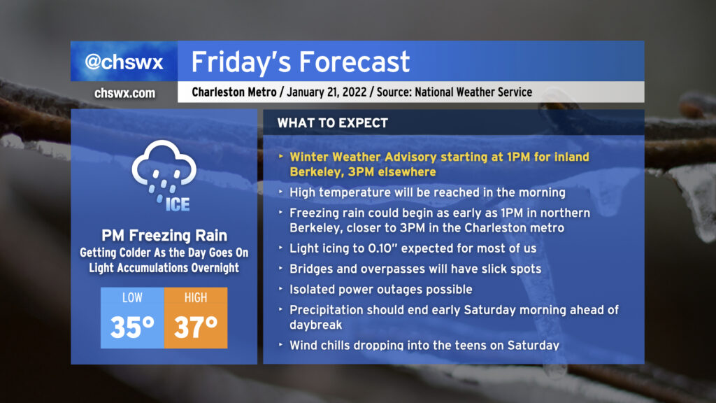
A cold front is sinking steadily southward in our direction this evening, which will allow a wedge of Arctic high pressure to steadily build in from the north as we get into Friday. We’ll start the day in the mid-30s, warm up to the upper 30s, and then temperatures fall below freezing in the afternoon, all while light rain blankets the area. As the freezing line moves southward, so will the changeover to freezing rain, generally on elevated surfaces (including bridges and overpasses.) This freezing rain threat will arrive by Friday evening and stick around through early Saturday before low pressure departs and brings the stalled front with it.
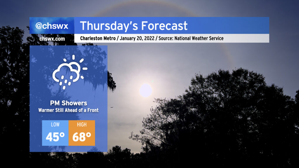
It’s going to be hard to believe that we’ll go from near 70° during the day Thursday to a winter storm come Friday, but that’s what’s going to happen. We’ll spend one last day in the warm sector as the cold front steadily pushes eastward; by afternoon, we should begin to see some showers work their way into the area ahead of said front. Rain will turn more likely as we get into the evening hours, so be ready for a wet commute home from work.
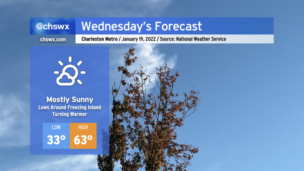
Wednesday’s weather looks pretty good. Temperatures will start out right around freezing — be sure pets and plants are protected once again tonight — with a nice warming trend up to the low 60s as high pressure slips offshore. All this will be under mostly sunny skies, with a few more clouds today than yesterday.