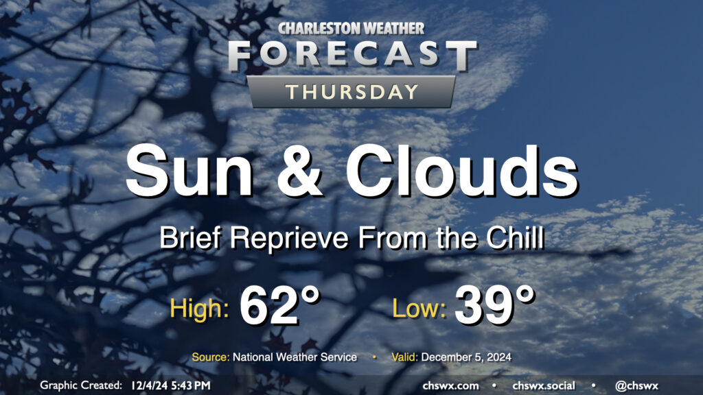
A warmer day is on tap Thursday as we sit between one Arctic-sourced high pressure system moving away and another approaching the area that’ll chill us right back out for Friday. We start the day in the upper 30s to around 40°, which will run much warmer than we ran on Wednesday morning after lows in the 20s for much of the area (and even some upper teens in northern Berkeley County!). Temperatures will top out in the low 60s in the afternoon as gusty southwest to westerly winds (perhaps approaching 30 MPH at times) ahead of the next front keep us a little warmer. We should see the front come through with little fanfare other than an uptick in cloud cover, especially in the first part of the day.
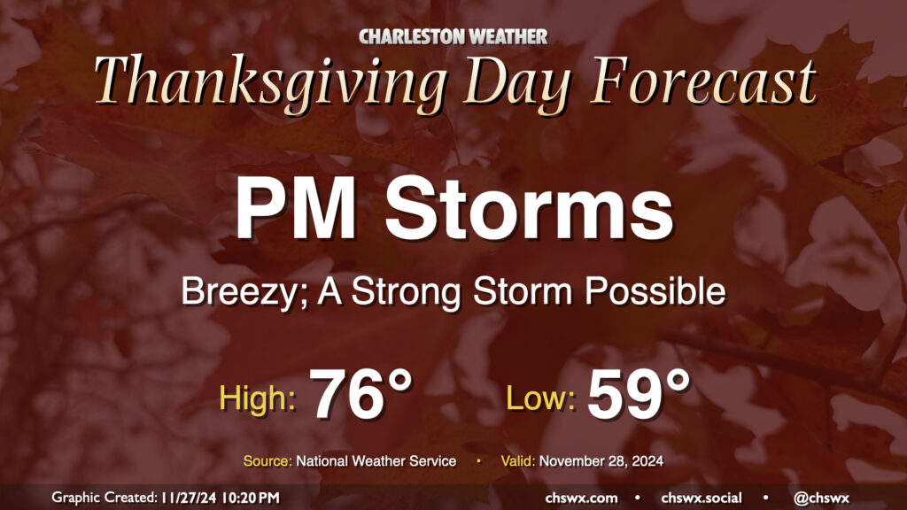
We won’t have the best weather on Thanksgiving Day, unfortunately, as a strong cold front moves through the area. It’ll bring with it some gusty winds and eventually some showers and even a few thunderstorms as we get into the afternoon and evening hours. It’ll be a warm and humid day by late November standards, with lows in the upper 50s to around 60° yielding to the mid-70s in the afternoon. This could help provide sufficient instability within a fairly well-sheared airmass to produce a strong to severe thunderstorm or two as the front approaches, with damaging straight-line wind gusts the main concern. The timing for storms appears to be generally between about 2pm-9pm, progressing west-to-east. It’s possible not everyone will see a storm or even any rain, but we just need to keep an eye on the storms that do fire to make sure they behave.
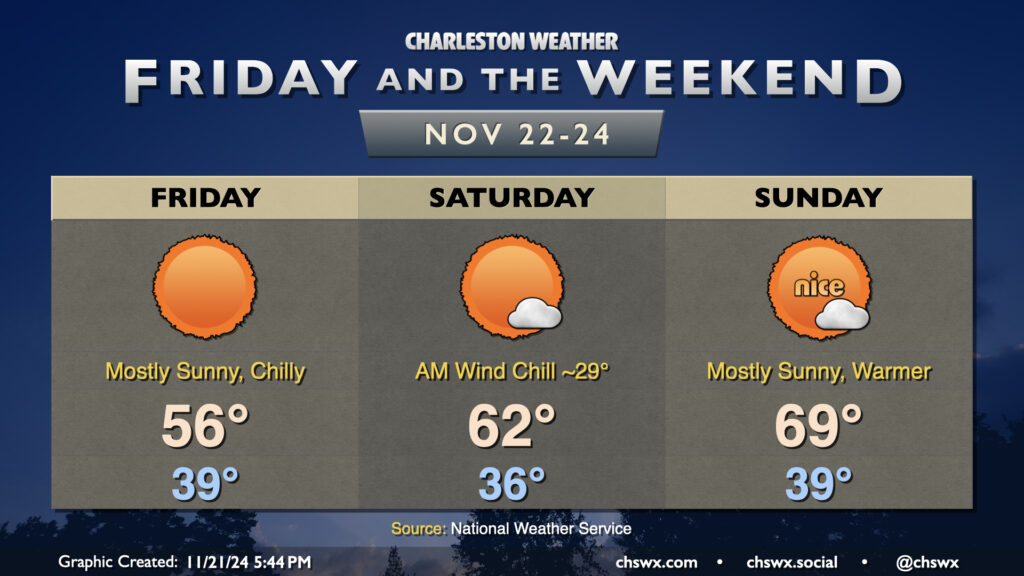
We have a chilly few days ahead as we close out the last work week before Thanksgiving. Friday will start in the upper 30s to around 40°, but factor in the wind, which will still be a bit breezy throughout the day, and it’ll feel closer to freezing as we head to work and school. Temperatures will then struggle to warm to the mid-50s in the afternoon despite full sunshine — a very wintry-feeling day, not so much like what a typical November day looks like.
Winds remain a touch elevated heading into Saturday, which will feature the coldest morning of the set. Expect temperatures to fall into the mid-30s in the metro thanks to continued cool advection and mostly clear skies; with the winds mixing in, it’ll feel more like the upper 20s at times. We’ll see a bit more of a rebound in highs, though, as the core of the coldest air lifts out of the area. Expect highs on Saturday to peak in the low 60s as the airmass begins to moderate. Another chilly start awaits on Sunday, with lows once again dipping into the upper 30s, but we’ll warm to near 70° in the afternoon under mostly sunny skies with a little lighter winds, too.
Looking for rain? It’s not looking likely for the next few days heading into Thanksgiving. We’ll be keeping an eye on a front for the middle of next week, which could kick up some rain chances for mid-to-late week, but it’s certainly not a done deal yet. Stay tuned.
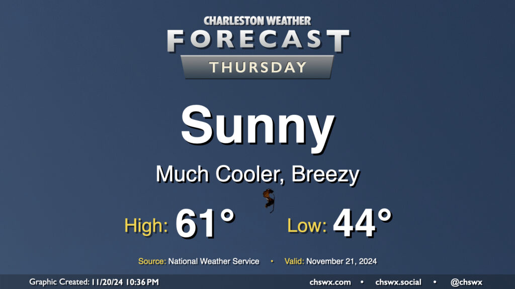
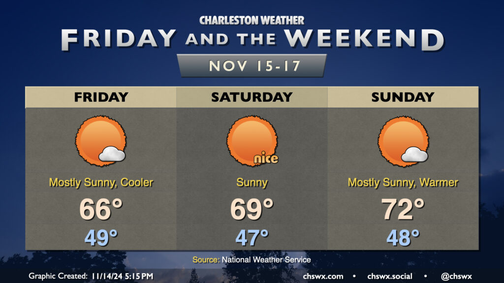
Thursday will kick off a stretch of below-normal temperatures that will continue into the first part of the weekend before we turn a little warmer for Sunday. We start Thursday in the mid-40s, but as cooler and drier air rushes into the area, producing some gusty winds at times, high temperatures will be limited to the low 60s at best despite full sunshine. This is closer to January normals than November normals — you’ll likely want to opt for some longer sleeves as a result, at least during the morning.
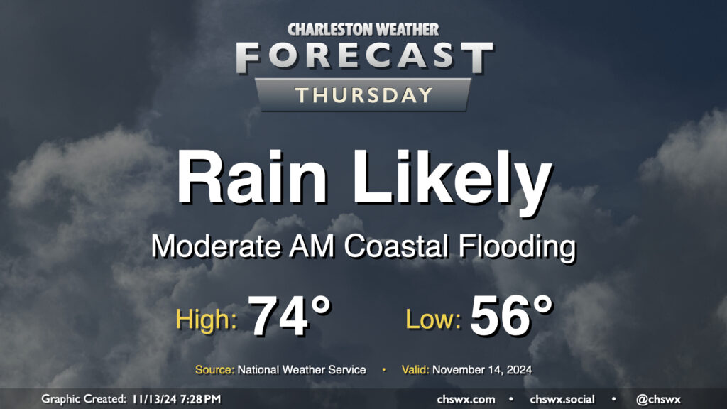
Showers scour out overnight Thursday, and by Friday morning, clouds will be diminishing as cooler and drier air works into the area. We’ll start the day in the upper 40s to around 50°, while the continued influx of cooler air will keep highs pinned to the mid-60s despite increasingly full sunshine. The only fly in the ointment will be the risk for minor to moderate coastal flooding around high tide, which should peak just before 7am. Water levels between 7.3-7.5′ are forecast, which will close some roads, though not as extensively as we saw Thursday morning.
Seasonable and quiet conditions continue for the weekend. Saturday should be a particularly nice day, with lows in the mid-40s yielding to highs in the upper 60s to around 70° in the afternoon, while temperatures turn a little warmer for Sunday as highs get to the low 70s after another upper 40s start. Sunshine will be very prevalent throughout the weekend, and I hope you get a chance to take advantage of weather that feels much more appropriate for mid-November.
Coastal flooding concerns will continue into the weekend, though, with major flooding expected with Saturday morning’s high tide as water levels are expected to peak around 8-8.2′ with the 7:46am high tide. Expect another round of numerous road closures in downtown Charleston on Saturday morning. Moderate to potentially major flooding can’t be ruled out for Sunday morning, either, as water levels once again approach 8′. Keep an ear out for Coastal Flood Watches, Warnings, and Advisories from the National Weather Service as your signal that travel could turn difficult.
Thursday figures to be a somewhat wet day at times across the Lowcountry, starting with salt water flooding downtown and ending up with showers across much of the area by evening.
First, the salt water flooding: Water levels around 7.9′ MLLW are expected with the 6:07am high tide Thursday. This will produce fairly widespread coastal flooding in downtown Charleston, and should also affect Long Point Road and parking areas around Shem Creek in Mt. Pleasant. Expect numerous road closures early on in the commute, with improving conditions heading into 8-9am. Be alert to detours around the aforementioned road closures, and never cross through floodwaters even if a road is closed — remember, this is all going to be salt water and that is incredibly not good for your car’s undercarriage!
The risk for showers should, thankfully, miss the worst of the salt water flooding. It will begin to kick up around mid-morning to midday, with the best chance of showers on Thursday afternoon into the early evening hours. Rainfall amounts should generally stay under a half-inch in most spots, but locally higher amounts are possible where heavier showers develop. Temperatures start in the mid-50s, topping out in the mid-70s early in the afternoon.
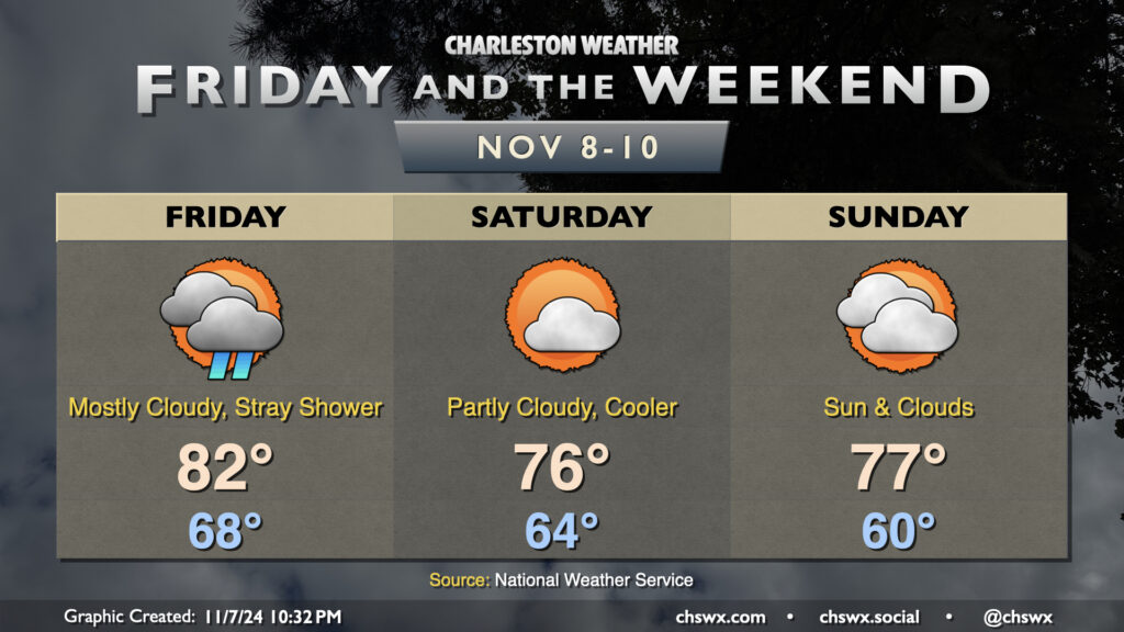
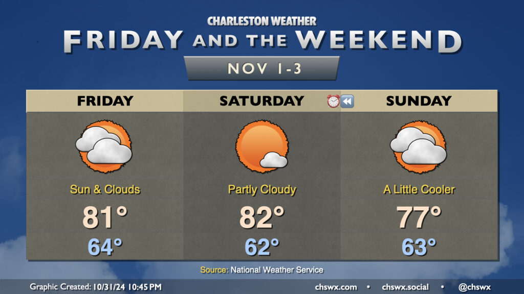
A brief respite from the really unseasonable weather arrives this weekend behind a front, but first we deal with Friday and the potential for a shower or two along with one more day of very warm temperatures. Expect lows in the upper 60s to yield to the low 80s in the afternoon with a mix of sun and clouds around the shower activity.
A front gets through later Friday, though, and this begins to temper things a little bit — though by no means anywhere near where we should be for this point in November. Expect a fairly nice day on Saturday, though, with lows in the mid-60s warming to the mid-70s in the afternoon under partly cloudy skies. A few more clouds arrive on the scene for Sunday, but we should stay rain-free again, with lows around 60° warming to the upper 70s in the afternoon.
We’ll briefly return to the 80s early next week before a front moves by on Tuesday. This front will help take the edge off some of the warmer temperatures, getting us much closer to mid-November normals, but still on the warm side of normal, with highs in the low to mid-70s and lows in the mid-50s expected starting around mid-week.
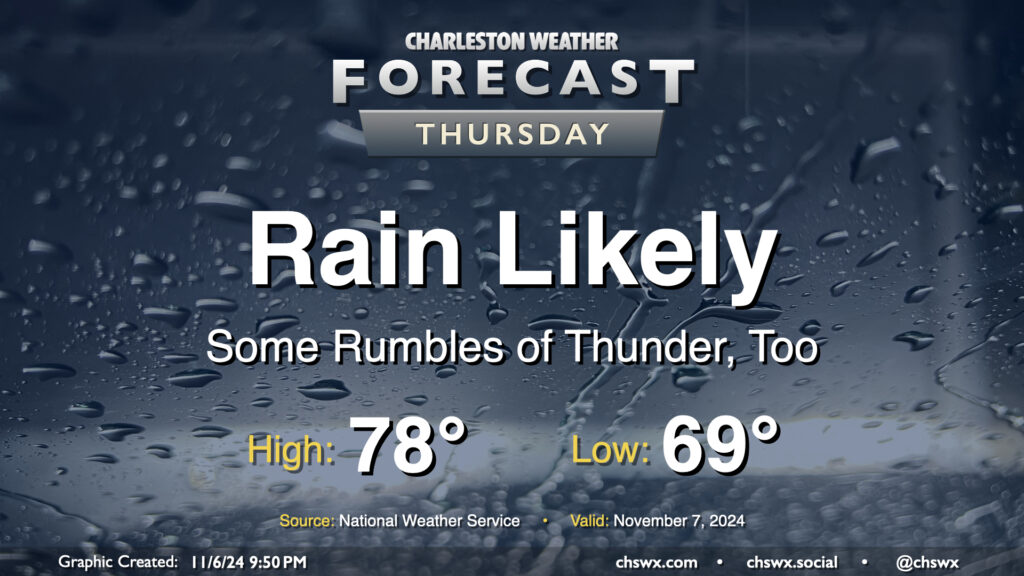
Rain continues on Thursday as northward-moving moisture from Hurricane Rafael interacts with a front. As far as average temperature goes, it’s going to be a particularly warm November day: expect to start the day in the upper 60s to around 70°, with highs topping out around 78° (largely governed by the expected rain). If it verifies, the low of 69° would be a new record warm low temperature for November 7, breaking the record of 68° set in 2018.
Rainfall totals should continue to climb across the area, with another 1-2″ possible across much of the metro overnight into Thursday evening. Expect the best chances for rain during the morning, with some scattering of the activity as we get into the afternoon and evening hours. Flooding doesn’t look to be a major concern here, but if training of rain does occur, some localized issues can’t be ruled out.
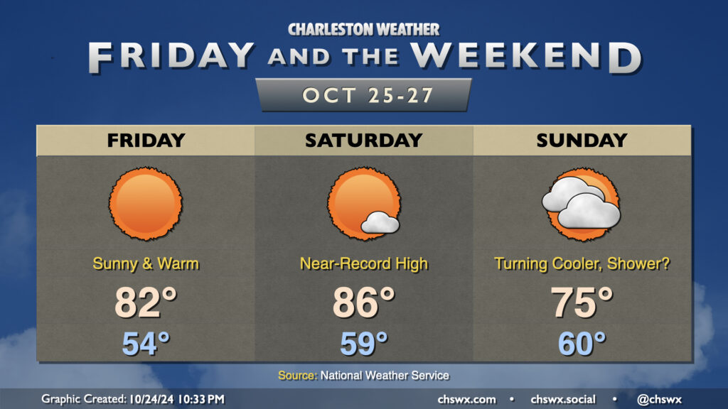
Unseasonable warmth rolls right into November as temperatures for Friday and Saturday remain upwards of 8-10° above normal for the start of the final month of hurricane season before a front cools things off slightly for Sunday. Overall, expect highs in the 80s on Friday and Saturday after starts in the low to mid-60s. A mix of sun and clouds will continue across the area, with perhaps a bit more sunshine on Saturday before a backdoor front moves by on Sunday, cooling us off a few degrees and thickening cloud cover once more.
Measurable rainfall remains extraordinarily difficult to come by; a few spots have had some sprinkles from time to time, but that’s about it. In fact, October 2024 is going to go down as the second-driest October on record with only 0.03″ of rain measured at the airport on October 4, and only traces of rain on a few occasions since then. This is second only to October 2000, when only a trace of rain was recorded that month. Records at the North Charleston climate site at the airport go back to 1937. As you can imagine, drought is developing over the area, and this week’s Drought Monitor puts much of the Lowcountry into moderate drought, while the rest of the state (except for a sliver of Lancaster and York counties) is now into Abnormally Dry conditions. We could certainly use a bit of rain, and none seems likely through at least the middle of next week.
Warm weather continues for Friday into Saturday ahead of a front that’ll knock temperatures down for Sunday. High pressure aloft will help drive highs on Friday into the low 80s, while we may flirt with record highs on Saturday as temperatures head to the mid-80s. (The record high for Saturday at North Charleston is 87°, set in 1939.)
A front moves through late Saturday into Sunday. It’ll kick up a bit more in the way of cloud cover, and after starting the day around 60°, we’ll warm to just the mid-70s under partly cloudy to mostly sunny skies. There’s an outside shot that some of us may get a shower or two as the front gets by, but I wouldn’t bank on it. The cooloff won’t last too long; after highs bottom out in the low 70s Monday, we’ll be back in the 80s in time for Halloween.