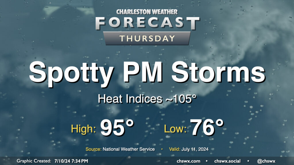
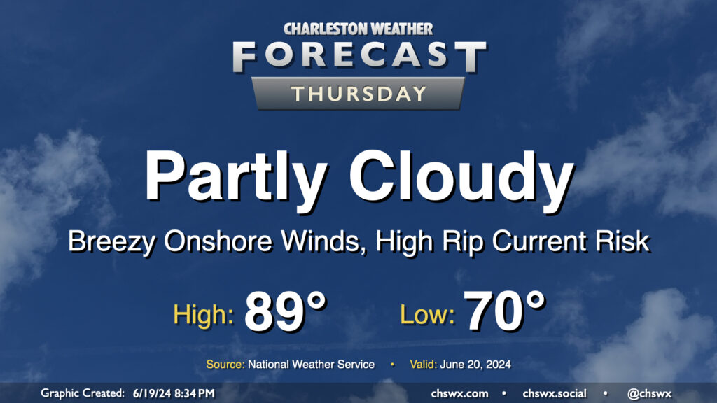
A stalling front will briefly usher in slightly drier air on Thursday, helping to keep heat indices below heat advisory levels, but it’ll still be plenty warm with air temperatures peaking in the mid-90s and heat indices in the mid-100s expected. We should still see a few showers and thunderstorms pop in the afternoon, but like Wednesday, coverage should be reasonably limited.
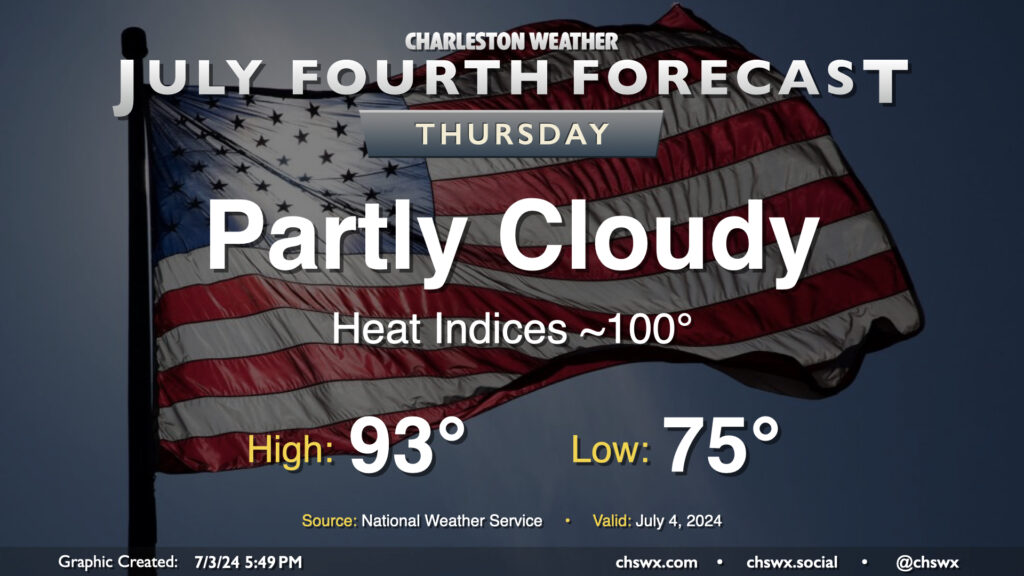
The Fourth of July should be a generally quiet weather day across the area, featuring partly cloudy skies and generally near-normal temperatures (read: still fairly hot). We start the day in the mid-70s and will warm to the low-to-mid-90s away from the coast, which looks to run more into the upper 80s to around 90°. The heat index will run around 100° as dewpoints remain a touch lower than they have been (generally low 70s). You’ll want the sunscreen with the UV index expected to run close to 10 at the height of the afternoon. Ridging aloft will keep a lid on any thunderstorm activity, removing Mother Nature’s fireworks from the equation this go-around.
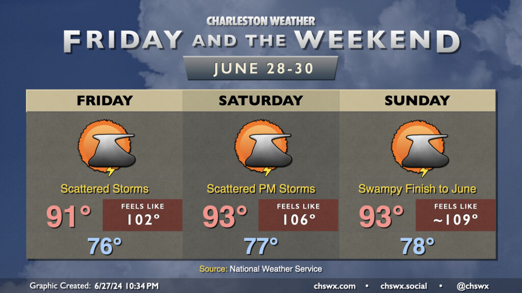
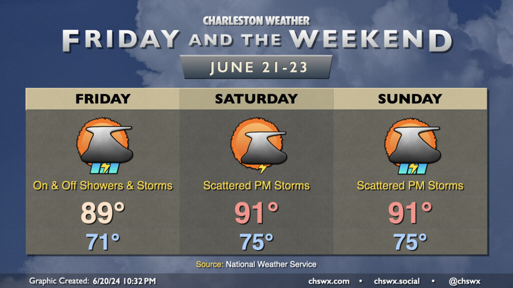
After some much-needed rainfall Thursday, we’ve got a few more shots at additional rain as we close out the month. In fact, the thunderstorm activity Thursday night will likely help keep temperatures and dewpoints down a little heading into Friday, with heat indices “only” in the low-to-mid-100s for many of us before thunderstorms fire in the afternoon. The early return from the late Thursday evening model runs suggests less storm coverage Friday than we saw Thursday, but some of us will still see another round of needed rain.
The active summertime pattern stays in place for Saturday into Sunday as well, with air temperatures in the low 90s combining with increasing dewpoints in the mid-to-upper 70s to prompt Heat Advisory-level conditions once again each afternoon before thunderstorms fire. Scattered coverage continues to be expected, with some of us getting luckier than others as far as rainfall goes. Some of the rain could be quite heavy at times, though, with minor flooding a possibility if it sets up in the more vulnerable locations. And as always, you can’t rule out a stronger or even marginally severe thunderstorm in the summertime; while there isn’t much to hang your hat on as far as organized storms, boundary and cell collisions can help bring down some strong wind gusts.
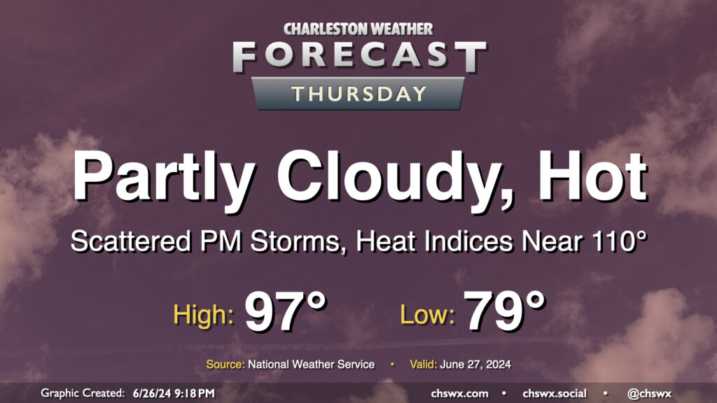
The meteorological status quo continues on Thursday: Heat, humidity, and a few storms in the afternoon. Temperatures will be fairly heinous on Thursday, with lows barely dipping below 80° away from the warmer coastline and highs getting into the mid-to-upper 90s in the afternoon. Mix in dewpoints in the mid-70s, and that’ll yield another day of dangerous heat indices in the 107-110° range. I’d be ready for yet another Heat Advisory to be issued for tomorrow.
A front sinking southward into the area combined with the usual seabreeze influence will help improve shower and thunderstorm chances for more of us tomorrow afternoon and evening. Pockets of heavy rain will be possible, and some gusty winds will be possible in any thunderstorm as well. A stray Severe Thunderstorm Warning certainly is in the cards, but widespread severe weather isn’t expected.
Humid days are here again: tropical moisture associated with a disturbance (which might become a tropical depression before coming ashore in Georgia tomorrow) will overspread the area, with showers and a few thunderstorms expected for a fair bit of the day as a result. It won’t rain all day at any one location — the rain will generally be off and on and be moving fairly quickly — so generally expect a half-inch of rain in most spots. A few locations could see locally heavier rainfall in the wetter storms. Thankfully, severe weather and flooding don’t appear to be major issues this go-around. Temperatures start in the low 70s, warming to the upper 80s between storms. It’ll be a muggy day as dewpoints surge into the low 70s by morning, with heat indices in the mid-90s expected.
High pressure gets into a typical summertime configuration starting Saturday, and we’ll definitely be feeling it as lows bottom out only in the mid-70s. The 90s return Saturday afternoon and will have some staying power through the weekend and well into next week, too. Showers and thunderstorms will be possible each afternoon along and ahead of the seabreeze, with locally heavy rain possible but severe weather generally not expected. Just be ready to bring outdoor activities inside if a thunderstorm approaches your location.
Thursday looks to remain mostly quiet over the area, though a few showers will be possible near the coast once again during the morning as showers within onshore flow reach land and dissipate in drier air. We start the day around 70° and warm to the upper 80s in the afternoon, much like the past few days. If you’ve been enjoying the somewhat lower-humidity mornings that we’ve had lately, enjoy this tomorrow morning because we’re shifting back into more traditional mid-to-late-June dewpoints starting Friday.
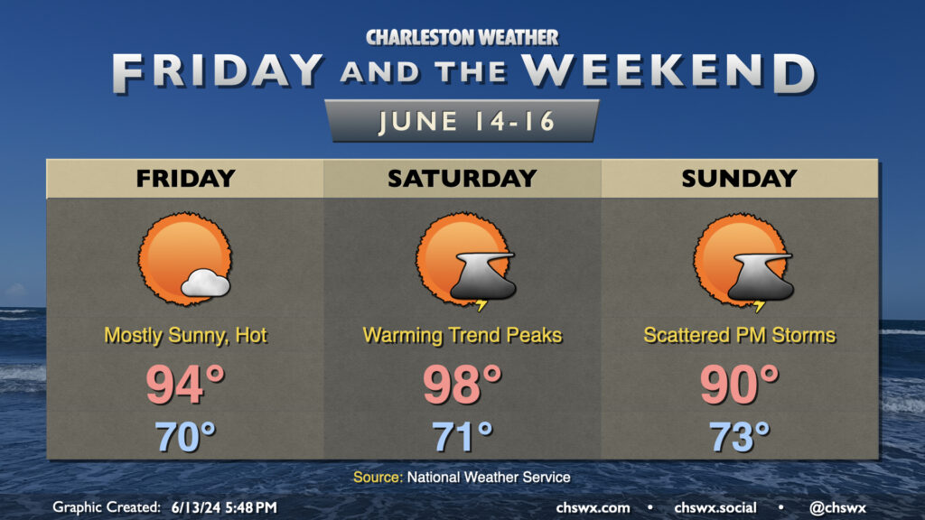
Temperatures climb fairly sharply before dropping off back toward normal as we get into Friday and the weekend. Friday will start around 70°, warming to the mid-90s in the afternoon under mostly sunny skies as ridging builds aloft. We make a run toward the Lachey mark on Saturday as highs top out near 98° away from the coast. Dewpoints in the low 70s will contribute to heat indices approaching 104° or so during the height of the afternoon, so be sure that you’re getting enough hydration and taking breaks if you’re going to spend time outdoors. Temperatures back off a bit for Sunday as the wind turns more onshore, but will still be plenty of warm with highs around 90°.
We’ll stay rain-free Friday, but the standard afternoon chance of scattered showers and thunderstorms re-enters the weather picture on Saturday into Sunday as another front stalls out nearby. Overall, though, we should see more sunshine than not. Try to stay cool!
Thursday could feature a few showers and storms brushing the coast as low pressure tries to organize along a stationary front that’s been lingering offshore for the past few days. It’ll otherwise be a fairly standard warm June day — lows in the low 70s yielding to highs around 90° in the afternoon under a mix of sun and clouds. Dewpoints in the upper 60s will help keep heat indices from getting too far out of hand, thankfully.
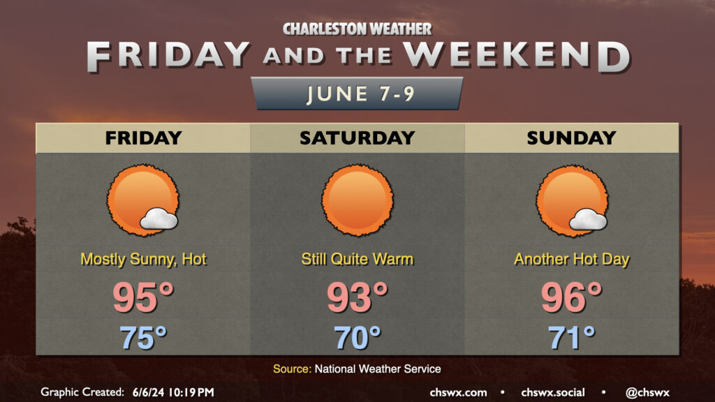
Mother Nature will come out throwing heat this weekend — thankfully coming along with lower dewpoints than we typically see in summertime. A “cold” front swings through during the day Friday, and while the airmass will trend drier, it’ll still be quite warm — highs in the mid-90s are expected. Thankfully, the drier air keeps heat indices within a degree or two of the air temperature. Sunshine will be in abundance, with the dry, sinking air keeping cloud cover at a minimum.
We’ll keep this going into the weekend. Saturday will be the “cooler” of the two days, but still plenty warm with highs reaching the low to mid-90s under mostly sunny skies. Sunday turns a little warmer and a touch more humid, with highs solidly in the mid-90s under mostly sunny skies once again. The next shower or thunderstorm chance arrives Monday afternoon as dewpoints continue to climb heading into next week.
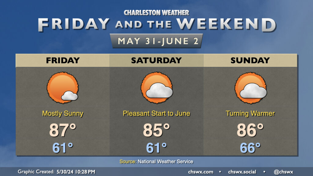
We’ll close out May with plenty of sun, temperatures generally near if not slightly below normal (especially in the mornings), and reasonably low humidity. Friday looks to run a little warmer than Thursday did, but the northerly breeze will keep the air on the dry side as dewpoints fall into the low 50s during the height of the afternoon. Expect mostly sunny skies, with just a few passing clouds as moisture remains a little tough to come by.
Saturday will be one more really nice day before a warming trend kicks in beginning Sunday. Temperatures on Saturday will once again bottom out in the low 60s, with highs in the mid-80s in the afternoon. Dewpoints will creep up a couple degrees, but it should still feel plenty comfortable outside as relative humidity values drop below 35% in the afternoon. Dewpoints begin to rebound to more June-like levels on Sunday as high pressure starts to slip offshore. Expect a milder start to Sunday with lows bottoming out in the mid-60s, warming to the mid-80s in the afternoon with a little bit more mugginess in the air as dewpoints return to the 60s. This warming trend continues into next week, with highs returning to the 90s and slight afternoon shower and thunderstorm chances coming along for the ride as well. But first, we have a beautiful weekend to enjoy — so enjoy it!