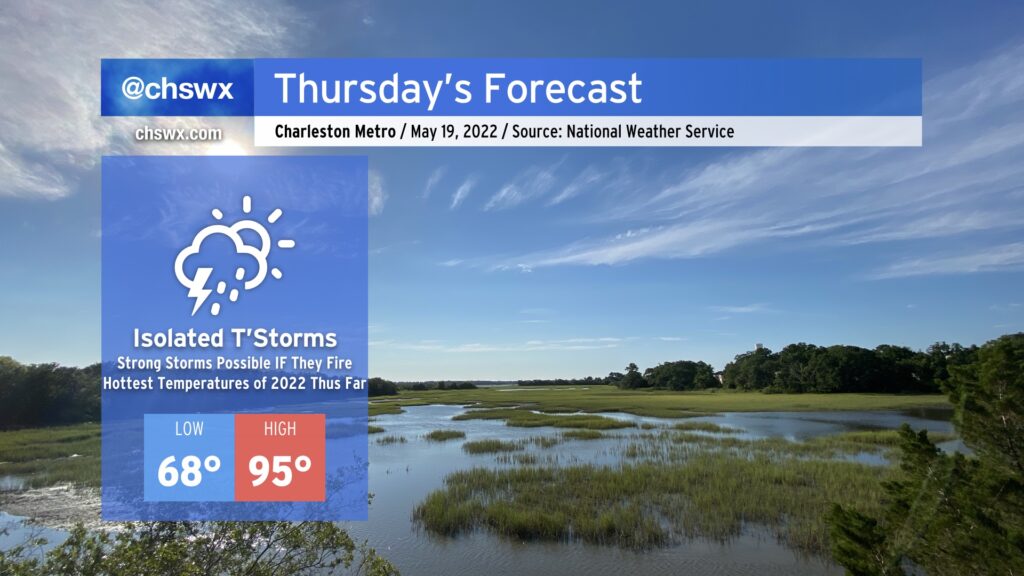
The hottest weather thus far in 2022 looks to arrive on Thursday. We’ll start the day in the upper 60s and warm well into the mid-90s in the afternoon. The record high of 96°, set in 1996, will be challenged under partly cloudy to mostly sunny skies. Heat indices could run close to 100° in the afternoon, so be sure to hydrate and take breaks accordingly.
As a series of mid-level disturbances ripple through the area, there will be a chance for showers and thunderstorms to fire off and move through in the late afternoon and evening hours. IF storms can fire — and this is a big IF — they could be on the strong to severe side. The thermodynamics certainly look good for storms to produce damaging wind gusts and large hail, but it remains to be seen if they can get going thanks to a strong cap on the atmosphere. Gonna be a game of wait, see, and watch the satellite and radar in the meantime.
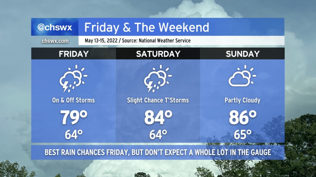
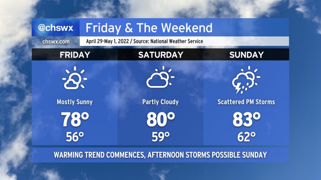
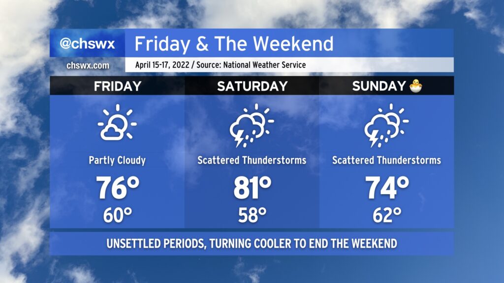
Low pressure, which has brought some generally light showers to the area today, will continue to push southwestward across the area for Friday and the first part of the weekend. The best rain chances arrive tomorrow as the low makes its closest approach, but aside from some pockets of heavier rain, storm totals should generally run around a half-inch to 3/4” at best — certainly not the drought-buster we need. Temperatures will top out a little warmer in the upper 70s to around 80° as winds begin to turn more southerly as the low moves inland.
Scattered showers and a thunderstorm or two will continue to be possible heading into Saturday as the low meanders westward. Southerly flow around the low will continue to keep the heat pump running, though, and highs should top out in the mid-80s in the afternoon after we start in the mid-60s. While a shower or storm can’t be ruled out for Sunday, most should stay dry, and temperatures continue to nudge upward in the afternoon on the higher end of the mid-80s. By next Monday, we should be in the 90s again, so soak up the last of this cool air while you can!
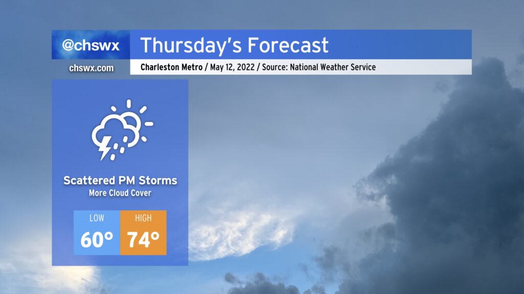
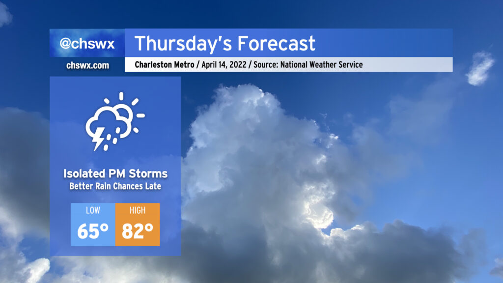
After a rather gorgeous — if not a touch windy — stretch of weather across the Lowcountry, rain chances return to the forecast for Thursday afternoon and evening as coastal low pressure drifts closer to the area. We’ll start to see an increase in cloud cover overnight into tomorrow morning, but the best rain chances should hold off until the afternoon. We may be contending with some showers for the evening drive, so be alert to that possibility. Temperatures will still run on the cool side as breezy north and northeast winds continue across the area; with the cloud cover and approaching rainfall, we shouldn’t see highs much warmer than the mid-70s.
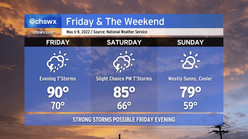
A cold front will come through this weekend, bringing strong storms to the area Friday evening before restoring order to temperatures by Sunday.
After hitting 92° at the airport today, we’ll climb back into the 90s on Friday afternoon. Much of Friday looks to remain dry (though a stray shower or two can’t be ruled out in the morning). However, we’ll be watching a squall line and an associated risk for severe weather push eastward through the Carolinas during the day. Damaging winds and large hail would be the primary concerns, though a tornado can’t be ruled out. The best risk of severe weather will be along and west of I-95. The line will be getting into the Charleston metro area later in the evening, and as a result, we should begin to see some weakening as daytime heating is lost. However, sporadic wind damage or hail will still be possible as the line pushes offshore, so you’ll want to keep an eye out for rapidly changing conditions Friday night.
The cold front will get through the area Saturday morning, but a deep trough aloft will still allow for a slight chance of showers and thunderstorms in the afternoon. Temperatures will top out in the mid-80s, a far cry from where we’ve landed the last couple days.
Pleasant weather returns in full force for Sunday. High pressure will build in, and the cooler and drier airmass will yield highs in the upper 70s to around 80° under mostly sunny skies. If there’s a pick day for getting out and about this weekend, it’s Sunday.
From there, seasonable temperatures continue for much of the new work week, with highs in the upper 70s to low 80s continuing at least into mid-week, with dry weather looking to stay in place until Thursday. But let’s not trouble ourselves too much with a new work week with a weekend on tap, shall we?
Generally good weather continues as we head into Friday and the weekend. We’ll see high pressure begin to slip offshore, allowing a little more warm and moist air to move into the area as the weekend goes on. This will allow temperatures to reach the low 80s on Saturday and run even warmer on Sunday.
With the influx of moisture and some upper-level energy coming through on Sunday, expect a scattering of showers and thunderstorms particularly in the afternoon. Definitely no washout here, just make sure you’ve got a backup plan for any outdoor activities. Remember: When thunder roars, go indoors!
The warming trend will continue well into next week, with some of the warmest temperatures so far in 2022 expected by mid-week. (But let’s enjoy the weekend first before we dive into another work week!)
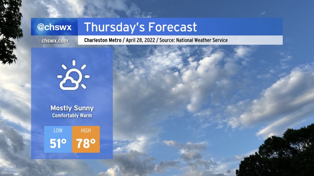
Thursday continues where today left off, with a seasonably cool morning followed by a comfortably warm afternoon in the upper 70s, right where we should be at this point in April. Humidity will be low once again as dewpoints mix out into the low 40s, yielding relative humidity values approaching 25% during the peak of the afternoon. It’ll be another good day for an outdoor lunch or evening walk as a result — just make sure you’ve got some sunscreen!
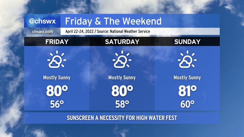
It’s going to be a pretty amazing weekend of weather, folks. Temperatures will return to the 80s as ridging continues to build aloft, and clouds will be at a minimum as high pressure rebuilds at the surface. The only weather concern I’d have is sunburn! Use sunscreen if you’re out and about, especially if you’re putting in a couple days at High Water Festival this weekend. Enjoy the excellent stretch of spring weather! We’ll stay dry through at least Monday before our next rain chances enter the picture later Tuesday.
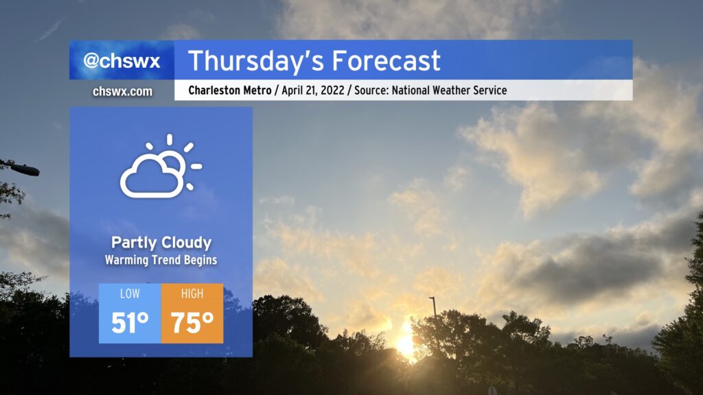
After another cool day by mid-April standards, we return to the 70s on Thursday as surface high pressure shifts offshore and we begin to see ridging start to build in aloft. We’ll have a few more clouds than we’ve seen in previous days with a little more available moisture, but they will be benign and non-precipitating.
A series of cold fronts will make for a bit of an unsettled forecast heading into the weekend. A washout is not anticipated, though.
Said front will come through sometime Friday morning, clearing out any shower activity from overnight. Cooler and drier air will punch into the area, setting up a rather nice day for many of us as highs peak in the mid-70s under partly to mostly sunny skies. It’ll be breezy, though, with gusty winds possibly approaching 30 MPH at times according to NWS. Keep this in mind if you decide to have lunch outside!
Unsettled weather returns Saturday as moisture return improves across the area and mid-level disturbances pass on by. These disturbances should kick off some scattered showers and some thunderstorms across the area, particularly in the afternoon. Ahead of thunderstorms, temperatures will top out in the low 80s across the area with the more warm and moist airmass returning to the area.
Sunday, another cold front will stall out across the area and another disturbance will ripple overhead. This will bring another round of scattered showers and maybe some thunderstorms to the area. Temperatures will run noticeably cooler behind the second front with highs only topping out in the mid-70s in the afternoon.
The good news in all this is that no severe weather is anticipated — getting the rain without all the other stuff is a win for our still-parched part of the world.
A cold front will approach the area Thursday, packing a (thankfully weaker) line of showers and thunderstorms that will continue to lose oomph as it trudges ever eastward. We should get a majority of the day in rain-free, with only slight shower and storm chances as we get later into the afternoon. Temperatures will rise into the low 80s despite the increased cloud cover. The better rain chances are pegged for later in the evening and into Friday morning, which you’ll want to keep in mind for dinner plans and beyond. Severe thunderstorms are highly unlikely in the Charleston metro area, with a low risk of severe weather around and west of I-95.