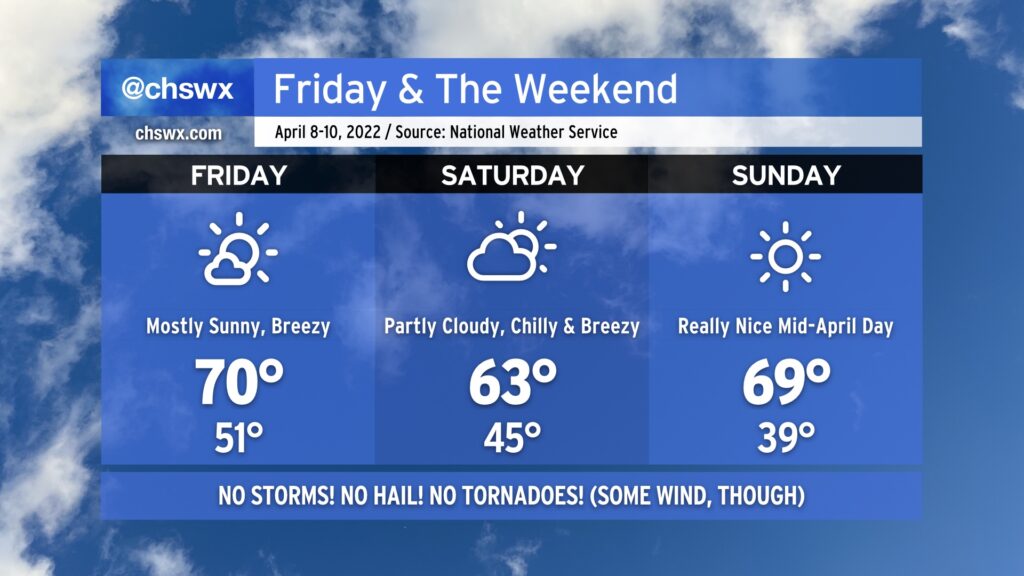
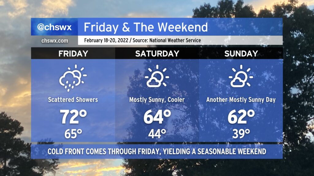
A series of cold fronts will usher in a pretty unseasonably cool airmass for Friday and the weekend. Tonight’s front, which was responsible for another round of thunderstorms that produced hail across the metro area, will bring considerably cooler and drier conditions for Friday. After starting out in the low 50s, highs will top out no warmer than the low 70s with mostly sunny skies throughout the day. Winds will be a little breezy behind the front as cold air advects into the area throughout the day, but it’s nothing we can’t handle at this point.
A reinforcing cold front comes through Friday night/early Saturday morning, bringing some cloud cover along for the ride (but it’ll be too dry for precipitation). After starting the day in the mid-40s, highs will only top out in the low 60s — temperatures that are much more reminiscent of January than April in these parts. Sunday morning starts even cooler, with lows in the upper 30s in the metro area. We could turn even cooler than that further inland, and frost may become a consideration. Temperatures do rebound to near 70° under full sunshine, though.
Rain-free conditions will continue through to at least next Wednesday if not Thursday as temperatures warm back to the low 80s by the middle of the work week. Enjoy the break from wacky weather!
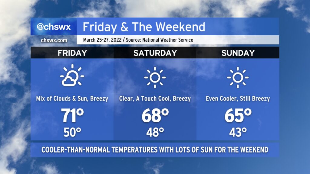
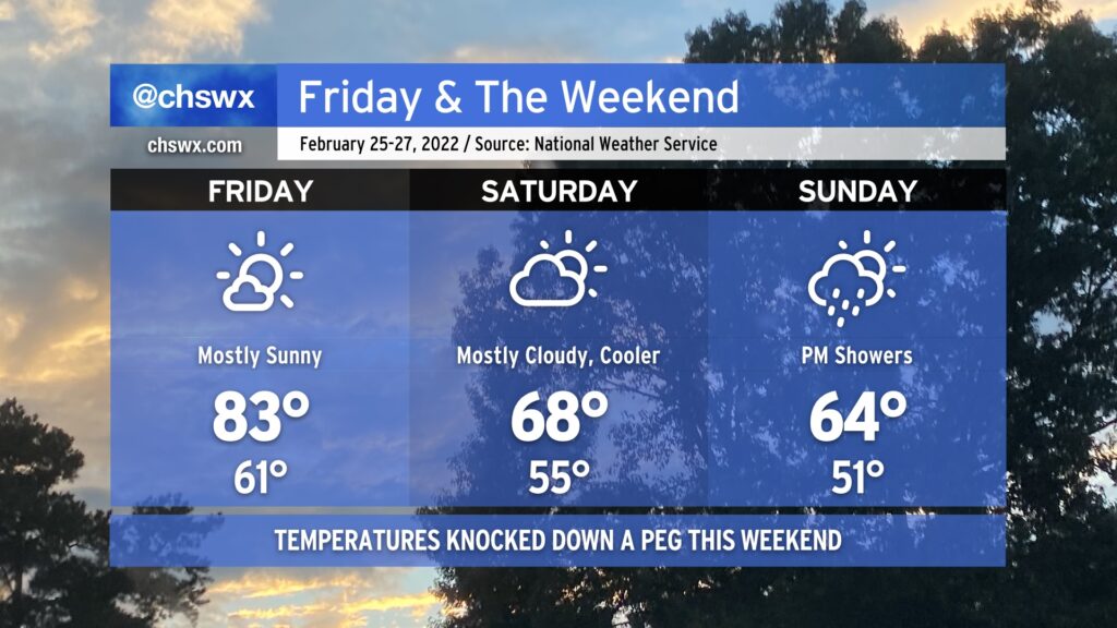
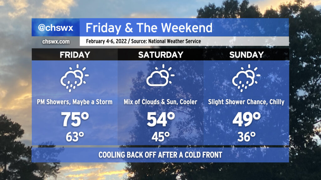
After some much needed rain Wednesday into Thursday, cooler and drier air builds back into the area for Friday and the weekend thanks to a series of cold fronts. Highs will top out in the low 70s on Friday with a mix of clouds and sun ahead of Saturday’s front, which will scour those clouds out and kick temperatures down a couple degrees, capping highs in the upper 60s to around 70°. Another reinforcing cold front gets through late Saturday into early Sunday, knocking temperatures back even further into the low 40s to start before only rebounding to the mid-60s in the afternoon despite full sunshine.
Through all of these frontal passages, expect gusty winds. Winds could gust upwards of 25-30 MPH on Friday, with gusts reaching or even exceeding 30 MPH on Saturday. Breezy conditions should also persist on Sunday as well. Keep this in mind if you have any outdoor activities planned, particularly those that involve tents or inflatables.
Fair weather persists into the upcoming work week, too, as a warming trend commences with highs approaching 80° by next Wednesday.
It’s turned out to be a pretty nice Thursday after a very foggy start. Temperatures topped out in the low-to-mid-70s across the area with plenty of sunshine emerging in the afternoon.
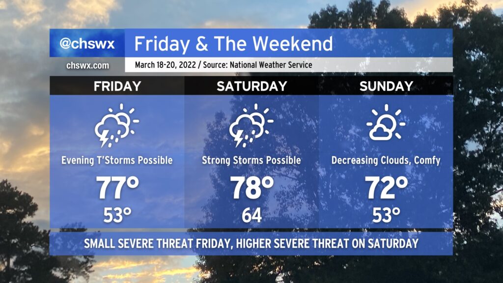
As we head into Friday and the weekend, another storm system will approach the area, bringing with it another round of showers and thunderstorms for some. Much of Friday should remain dry; temperatures ahead of the front will get into the upper 70s under partly cloudy skies. Thunderstorm chances increase with some upper-level energy moving in Friday evening. There’s an outside shot for a storm to briefly become strong or severe, with damaging winds the main concern, but that risk is conditional on whether any instability can develop.
Saturday could have a bit better severe weather threat as the cold front moves through. Wind shear will be favorable, and as long as Saturday doesn’t stay too overcast or showery, some decent instability should develop. This could lead to thunderstorms with damaging winds and large hail. A tornado isn’t off the table, either, with a little low-level shear indicated in the guidance suite. Temperatures look to head into the upper 70s once again before the front gets through later in the day.
Sunday looks great, though! A cooler and drier airmass will move into the area overnight, yielding lows in the low 50s and highs topping out in the low 70s under mostly sunny skies. It’ll be a little gusty as high pressure builds in behind the front, but there are no other weather concerns.
Quiet weather continues Monday into Tuesday before the next storm system and accompanying thunderstorm chances arrives on Wednesday.
This weekend’s weather encapsulates the power of March in a nutshell: Cold air damming, followed by a severe weather threat, followed by an Arctic blast.
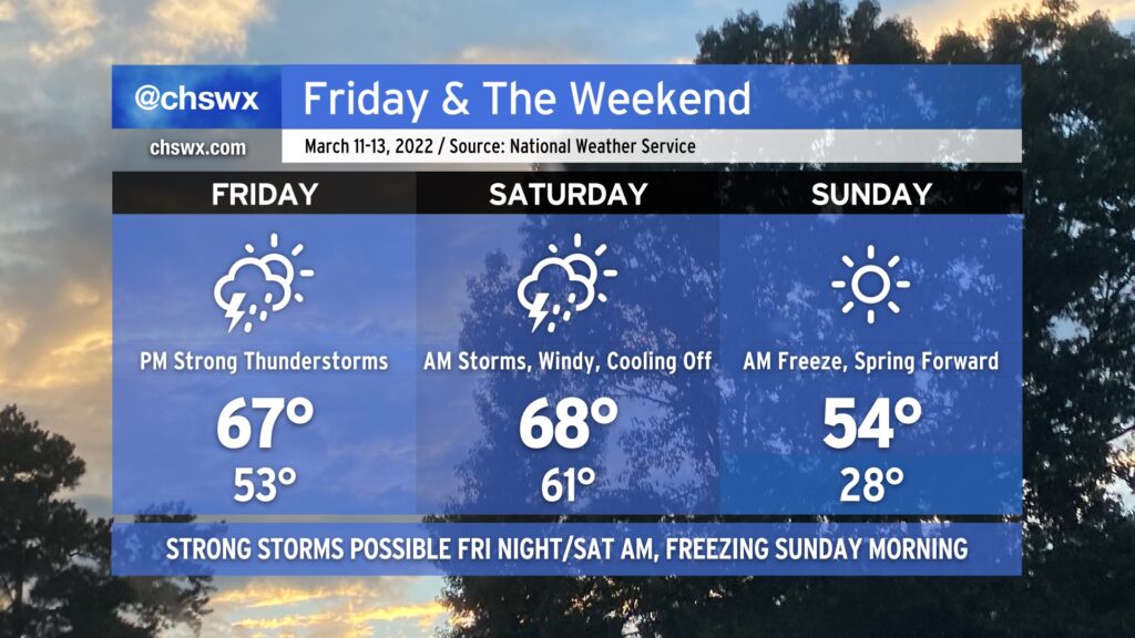
We’ll start Friday within the cold wedge that’s kept it cloudy and chilly across the area today. During the day, a warm front should lift north of the area, scouring out the wedge and putting us back in the warm sector of an approaching storm system. Showers and thunderstorms will be on the uptick as the front approaches, and a few of those could turn strong to severe especially as we get into Saturday morning. Guidance is pretty consistent in depicting a squall line-like feature moving through the area to start Saturday, promoting a damaging wind threat. A tornado or two could be possible inland as well, with that risk decreasing as you get closer to the coast and significantly cooler shelf waters.
After the front gets through Saturday morning, conditions will turn quite windy by afternoon as Arctic high pressure builds in from the northwest. The high temperature will be attained in the morning as we’ll cool off fairly substantially post-frontal passage, with temperatures just in the mid-50s in the afternoon.
Saturday night into Sunday morning, clocks will spring forward and temperatures will fall way back into the 20s in much of the metro area, with freezing temperatures possible to the coast. I’d advise everyone with tender vegetation to be ready for a freeze regardless of where you are; cover or bring in those sensitive plants and do not forget about your pets, either!
The chill will be short-lived heading into the new work week; we’ll be back in the 70s by Tuesday (along with another storm system).
For the second straight day, we reached a record high at the airport as the temperature peaked at 84° a little after 2:30 PM. This broke the previous record high of 83° set in 2018. (The normal high for this point in February is 66°.)
The early evening surface analysis showed a wedge front stalled out roughly north of I-20. Ahead of that front, temperatures were in the upper 70s to low 80s. Behind that front, temperatures were in the 60s and below! This front is not going to make it this far south for tomorrow, though, which will allow Friday’s temperatures to once again soar into the 80s under partly cloudy to mostly sunny skies. The record high of 86°, set in 2018, will bear watching.
Patches of fog will be possible in the morning, so be ready for brief disruptions in visibility during your Friday morning commute.
By Friday evening, though, the frontal zone will be moving through the area, yielding a much cooler weekend. Temperatures on Saturday will struggle to the upper 60s under partly to mostly cloudy skies. (68° is still a couple degrees above normal for this point in the year, though.) On Sunday, a few showers will be possible as a disturbance passes by overhead. We’ll run a few degrees cooler with highs generally topping out in the mid-60s in the afternoon.
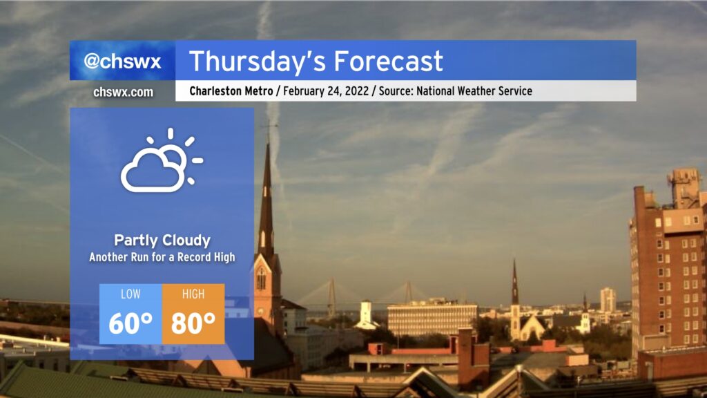
Wednesday was a very unusually warm February day in the Lowcountry. The high of 86° handily obliterates the daily record for February 23 of 82° set in 2018, but today also marked just the fourth time since records began in 1938 that the high temperature reached 86° in February. Previously, this happened on February 25, 2018, February 16, 1989 (when the high was 87°, setting the all-time February record), and February 28, 1962.
We look to take another trip into the 80s tomorrow. While surface flow coming a touch more off the Atlantic may modulate temperatures a bit, it is still certainly possible we may at least tie the daily record of 83° set in 2018. Fog may be a greater issue tonight and tomorrow morning, though, with lighter winds making for more favorable conditions for fog development. This fog could be dense, so be ready for visibility restrictions as you commute Thursday morning. The slightly more onshore trajectory could also help spread sea fog inland later in the day, which would have a chilling effect on temperatures as well. As usual with our weather, there’s so many variables to watch, even when there’s no precipitation involved. But regardless, prepare for another absurdly warmer-than-normal February day.
We’ll be dealing with some showers on Friday as a cold front swings through the area. It’ll be one more day of unseasonably warm temperatures — the forecast low of 65° Friday morning is around the normal high for this part of the year — but those will come to an end with the frontal passage. The weekend looks great — mostly sunny skies with seasonable temperatures at or a touch below normal are in the forecast as high pressure builds across the area. Hope y’all get a chance to enjoy it a bit!
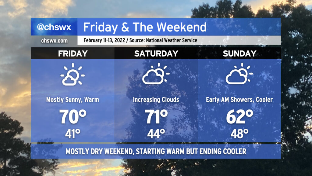
After an absolutely gorgeous day today, we’ve essentially got a repeat on tap for Friday as high pressure remains in control of our weather. Temperatures will once again top out right around 70° with low humidity continuing. Try to get outside if you can!
Saturday may actually run even a touch warmer, but increasing cloud cover will portend changes coming to the area as a cold front approaches the area Saturday night. Right now it looks to come through sometime Sunday morning, which should act to knock high temperatures down around 10° from the previous day. Even colder air will arrive for Valentine’s Day, but temperatures look to moderate back to spring preview levels as next week goes on. Overall, it looks like we’re going to end February on a warmer note, and that isn’t too shabby considering the pretty chilly stretch we’ve been in over the last month or so.
Our spring preview has one more day to go before a cold front comes through later Friday and knocks temperatures down quite a bit for Saturday. We’ll see rain chances head up as we head into Friday afternoon and evening, with even a chance for a rumble of thunder or two. Instability will be lacking, but the shear should be enough to support a couple thunderstorms. It won’t rain all day, though, with the best chances around dinnertime.
We turn much cooler Saturday in the wake of said cold front. We’ll see a brief round of clearing on Saturday before a coastal low develops near Florida and heads northeastward, helping to drive a wedge of cooler air southward and keeping a shower chance around near the coast for much of the day. (That being said, it will not rain all day at any one location, either!) Temperatures may not get out of the upper 40s on Sunday. The good news? No sub-freezing temperatures are in the forecast, thus there are no winter weather concerns.
Despite winds going back around to the northeast later Saturday into Sunday, we’re far enough removed from the perigean spring tide where coastal flooding doesn’t look to be a concern for the weekend. It’s been an active year for coastal flooding already, with 11 events in 2022 so far, and we’re just into February 3rd. This already beats 1998’s total of ten coastal flooding events in that year’s first two months.
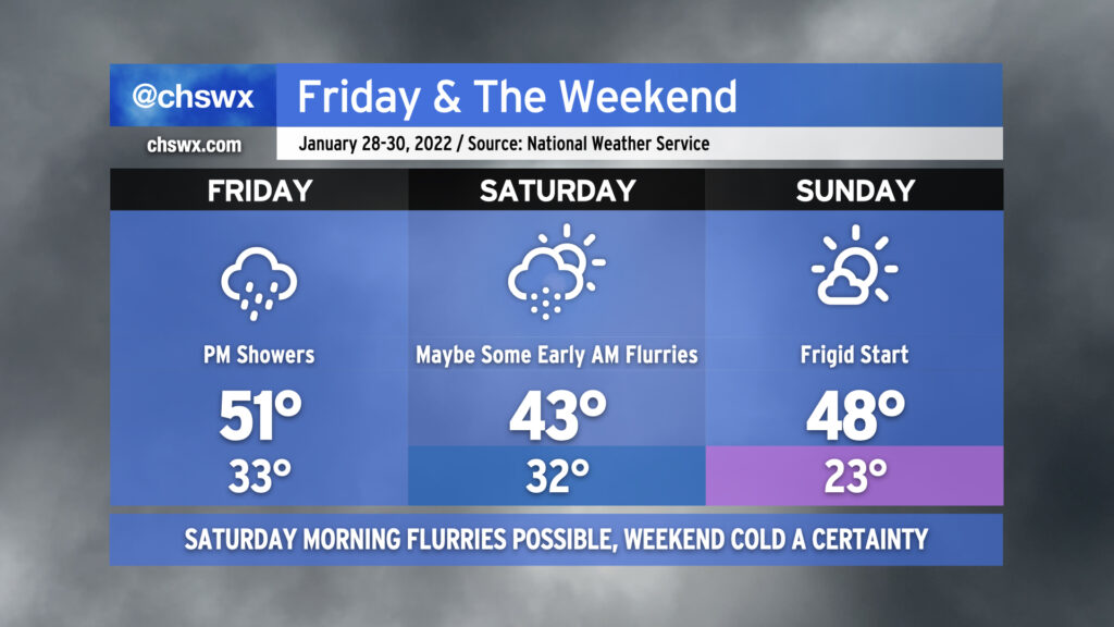
Well, here we are getting into the weekend with another storm system primed to affect the area. Overcast skies will be the rule for much of Friday as showers develop in the afternoon on the periphery of offshore low pressure. Temperatures will only top out around 50-51° given the lack of sunshine and northerly component to the wind.
As we get into the overnight hours Friday into Saturday morning, showers could give way to some snow flurries as colder air punches into the area. I always urge caution with cold-chasing-moisture scenarios like the one we will find ourselves in, but as an upper low traverses the area on the heels of the surface low pressure system moving northeast, it’s certainly conceivable that parts of the Tri-County, especially along and north of a Summerville-Moncks Corner-Jamestown line, could see a period of snow. Flurries will be possible all the way to the coast and perhaps as far south as Edisto as we get toward daybreak Saturday. Accumulations, if any, will be quite light and confined to grassy surfaces, and travel disruptions are not expected. And yes, folks — there will be no ice.
While the risk for snow is still quite conditional (and, to be fair, may not fully pan out), the certainty in the forecast is another shot of Arctic air that will turn this weekend frigid. Temperatures will struggle into the low 40s on Saturday afternoon despite cloud cover scouring out, producing clear skies by the afternoon. Sunday morning is setting up to rival the coldest of the season with lows in the low 20s expected in the Charleston metro area. This is potentially pipe-busting cold, and you’ll need to make sure that pets, plants, pipes, and people are safe and sound Saturday night into Sunday morning. Any bit of light wind could bring the wind chill factor into the upper teens on Sunday morning, too. We’ll keep plenty of sun in the forecast for Sunday, but even then, highs will likely not crack 50°.
The good news is that we begin a sharp warming trend on Monday. As we get into later in the new work week, we may even flirt with 70° for a time. With that in mind, though, the large scale pattern continues to favor generally cooler-than-normal conditions in the eastern half of the US, so don’t change out the wardrobe at the first sign of upper 60s just yet.