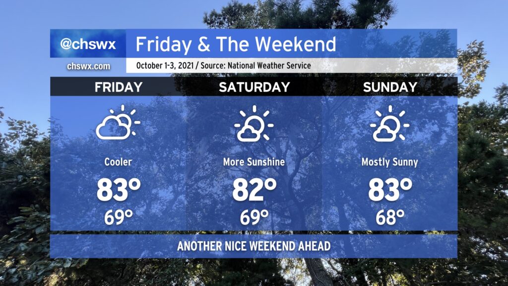
All in all, expect another nice weekend across the Lowcountry as a little cooler air works down into the area over the next few days. Temperatures will generally top out in the low to mid-80s across the area, with lows in the upper 60s inland and the low 70s near the coast. Aside from a small risk for a shower or storm tonight, particularly in the upper reaches of the Tri-County, our next appreciable rain chance doesn’t arrive until next Tuesday.
The tropics remain busy, but Hurricane Sam and recently-minted Tropical Storm Victor are staying out to sea and are not threats to the Lowcountry. We may see some enhanced rip current risk and wave action from Sam over the next few days, so be aware of this risk if the beach is in your plans. Otherwise, no concerns. Fingers crossed it stays this way — we’ve got two months to go in what has been a very busy 2021 hurricane season.
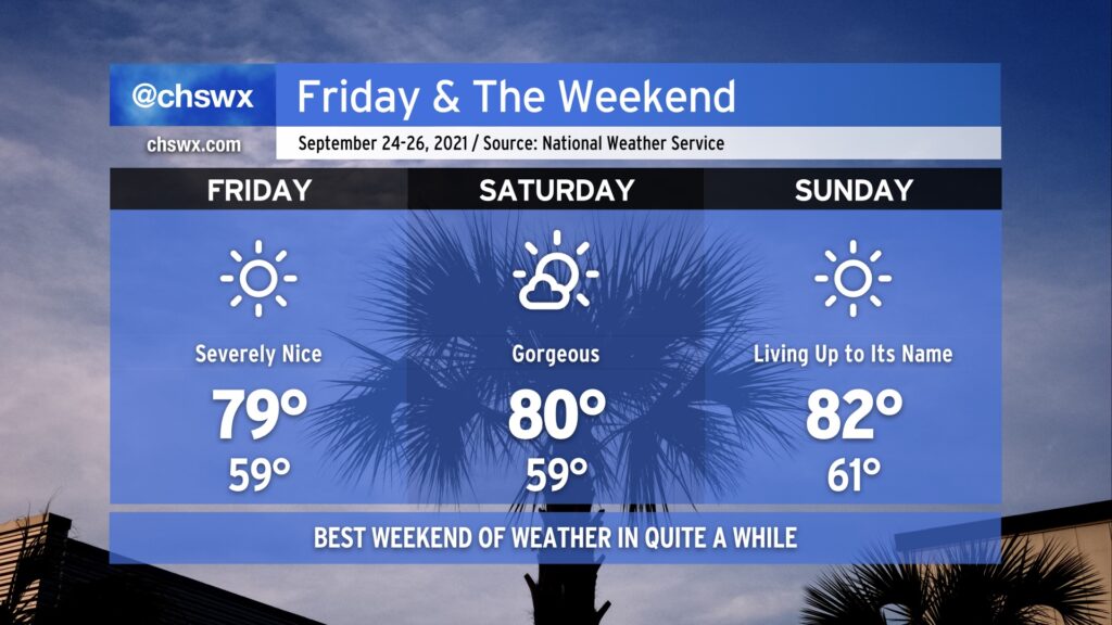
We’ve earned it: A beautiful weekend is imminent as the first really solid shot of fall weather, ushered in by a cold front that swung through late last night, continues for the next several days. Lows look to bottom out in the upper 50s for the first time since June 1, and we likely will top out right around 80° under full sunshine. Similar conditions, with perhaps a few more clouds, continue into Saturday. Sunday will certainly live up to its name, with temperatures beginning to moderate ever so slightly back to the low 80s with continued low humidity.
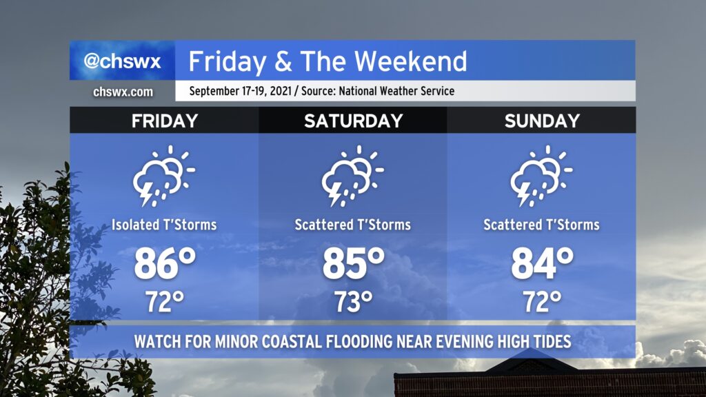
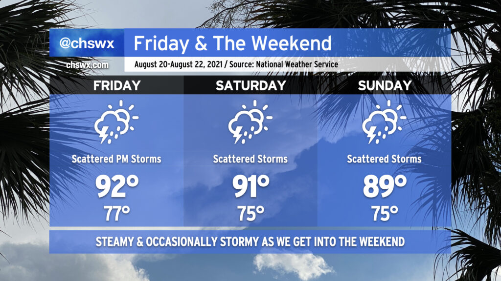
We will remain in a warm and muggy regime on Friday into the weekend as tropical moisture remains in place over the area. We should see a little less shower and storm coverage on Friday as compared to today without much in the way of forcing, but a few airmass thunderstorms will be possible especially ahead of the seabreeze. Saturday looks similar right now as forcing mechanisms remain few and far between. Heading into Sunday, though, upper-level energy will rotate into the area, and this should help enhance shower and thunderstorm coverage especially in the afternoon and evening hours. A total washout is not in the cards, though, so don’t go torching your weekend plans — just keep an eye on the forecast as there will be adjustments and fine-tuning throughout the weekend.
Temperature-wise, we’ll remain generally in the mid-80s each afternoon after starting out in the low 70s each morning (with perhaps some upper 70s to around 80° lows close to the coast, including downtown). Temperatures should be knocked down a peg for Sunday given more expansive cloud cover and shower and thunderstorm activity in the region.
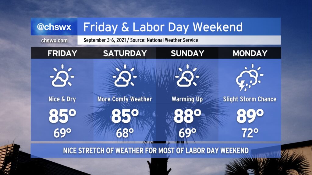
You can likely already feel it in the air — drier air has filtered into the area today, and it feels so much better outside already after a really humid August. A stretch of nice weather will ensue, with temperatures running a little below normal for Friday and Saturday. Lows in the mid-to-upper 60s will feel pretty good, for sure, and we’ll top out in the mid-80s Friday & Saturday. Temperatures moderate a bit higher on Sunday, with dewpoints creeping up as well. Humidity does make a comeback for Monday with a slight chance of afternoon thunderstorms, but all in all, the vast majority of us will stay dry this Labor Day weekend. Hope you can take advantage!
High pressure will continue its influence on our weather as we head into the final weekend of August. Temperatures look to remain in the upper 80s to around 90° each afternoon with warm starts in the mid-70s away from the coastline, where temperatures continue to struggle to get below 80° each morning. The aforementioned high pressure will act to keep shower and thunderstorm activity to a minimum through the weekend, certainly welcomed considering how soggy of an August we’ve had.
High pressure will also keep Tropical Storm Ida, forecast to become a hurricane as it approaches the central Gulf Coast this weekend, out of our hair. Unfortunately, it looks to be another direct strike on Louisiana, an area that is very tropical-cyclone weary after the numerous storms it dealt with last season. If you have friends or family there (as well as in coastal Mississippi and Alabama), please make sure they understand that time is of the essence to prepare as tropical storm-force winds could begin as soon as Saturday evening along the coast. Ida is forecast to make landfall sometime Sunday evening along the Louisiana coast. From there, its moisture may get caught up in a frontal system and help provide the juice for another round of wet weather here next week.
For now, though, enjoy a relatively quiet weekend of weather in our neck of the world.
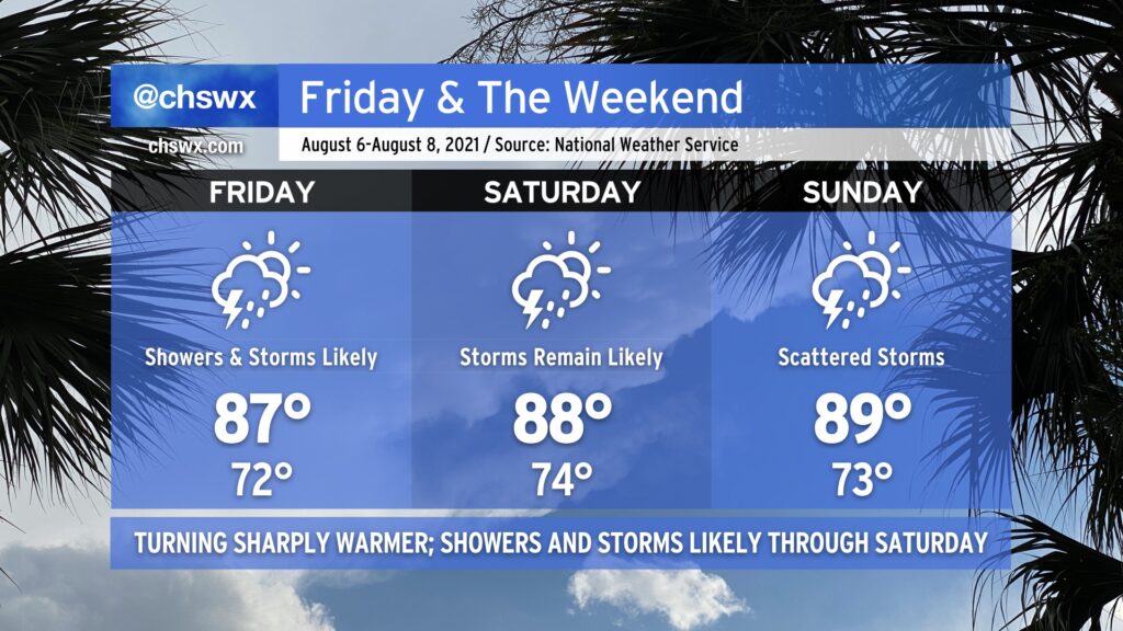
We remain in a bit of an active pattern heading into the weekend as disturbances traversing an upper-level trough over the region help to enhance coverage of afternoon thunderstorms. Heat and humidity will continue, with temperatures in the low 90s for Friday and Saturday in particular. Dewpoints remain quite elevated — mid-to-upper 70s will be common, especially after the seabreeze moves inland — and this will keep heat indices in the 100-105° range before thunderstorms break up the party a bit.
Much like we saw Thursday evening, thunderstorms that fire will be capable of producing very heavy rain, a lot of lightning, and likely won’t be moving too terribly much, either. Thus, the risk for isolated flooding events continues. Thunderstorms could become briefly severe where outflow boundaries and cell mergers occur, with wet microbursts a distinct possibility in the strongest storms, but widespread severe weather is not expected. The good news is that it won’t rain all day, but when storms do fire, you’ll want to be headed indoors as they will be prolific lightning producers.
Long story short: Keep your water bottles and rain gear handy, because you’ll need both at times throughout the weekend.
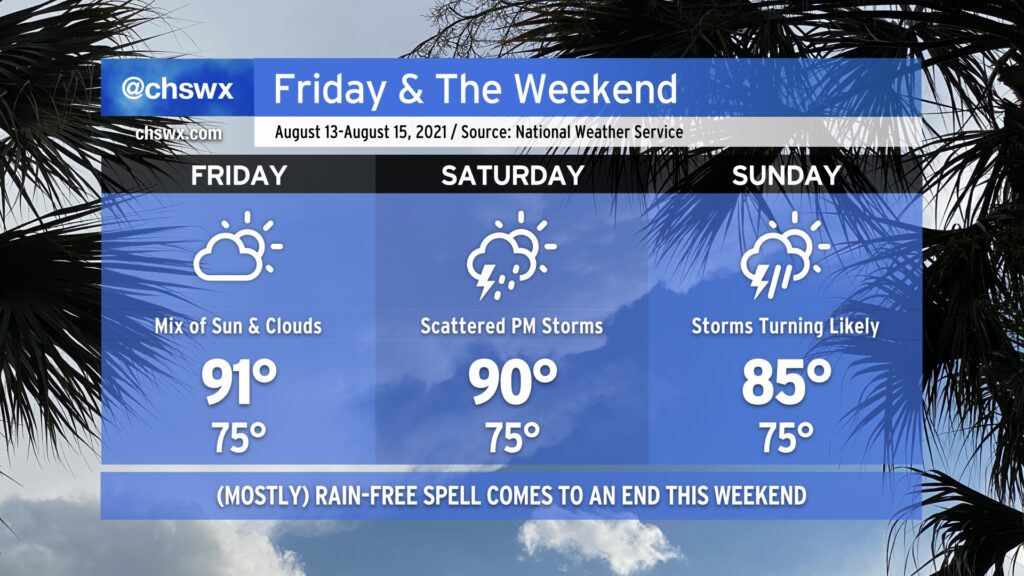
Friday gives us one more day of warm and mostly rain-free weather before the pattern turns back toward being more unsettled. Like today and the past few days, expect highs to top out a little over 90° in the afternoon, with heat indices in the low 100s. As always, a stray shower or thunderstorm can never be ruled out because, well, summer.
Our quieter weather pattern begins to shift back toward a more unsettled setup as the weekend wears on. Expect scattered thunderstorm coverage on Saturday, with highs topping out around 90° outside of those storms.
A front will sag southward into the area as we get into Sunday, stalling out over the Carolinas as Fred — forecast as a tropical storm — approaches the Florida panhandle (based on the current NHC forecast). The influx of tropical moisture with the nearby frontal boundary could spell some heavy rainfall at times across the area starting Sunday and into early next week. Stay tuned to forecast updates as the rain threat evolves.
After two straight days of 70s — the earliest that’s happened in August on record — a warm front will lift across the area late tonight into Friday morning. Said warm front will scour out the cool season-esque wedge of high pressure that’s been in place for the last couple days and bring warm temperatures and humidity back to the Lowcountry. This, too, combined with good mid-level forcing from a trough approaching from the west, will keep plentiful showers and thunderstorms in the forecast through Saturday.
With the wedge scoured out, we shouldn’t have quite as much overcast as we’ve seen the past few days. The change in airmass and ensuing periods of sunshine between storms will allow high temperatures to rise through the upper 80s each day through Sunday. Mix humidity in, and it’ll feel closer to the mid-90s on Friday, and will feel closer to 100° Saturday and Sunday afternoons. (At least it’s not 115° like this time last week!)
The trough that’s responsible for Friday and Saturday’s shenanigans will shift eastward as Sunday goes on, giving way to weather that’s more characteristic of early August to start the next work week. The fall preview was nice, though, and it’s a nice reminder that we’re coming through the peak of summer now, with the cool season not too terribly far off.
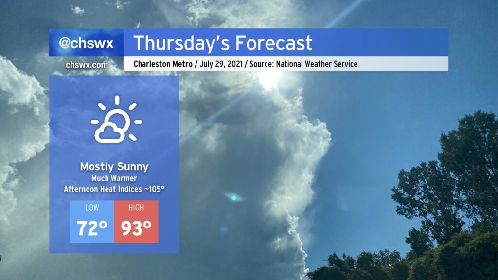
We’ll trade the persistent rain of the last few days for a real taste of summer beginning on Thursday. Temperatures will easily rise into the low 90s in the afternoon under mostly sunny skies as high pressure builds in aloft and at the surface. The humidity will make it feel closer to 105°, which is as hot as the heat index has been all summer. Take appropriate precautions: Plenty of water, plenty of shade, and most importantly, look before you lock. One hot car death is too many.
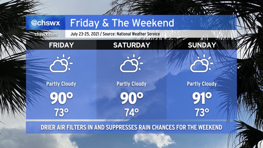
After another day of very heavy rain in the Charleston metro area — this time in West Ashley — we mercifully get Friday and the weekend to dry out a little bit as a front sags south of the area, turning winds to the east and northeast. This will keep temperatures right around, if not slightly below, late July normals. Heat indices will even be reasonably in check — upper 90s on Friday, but down to the mid-90s for Saturday and Sunday.
With the drier air comes a little less cloud cover and far lower shower and thunderstorm chances (though I suppose you can never totally rule out an afternoon shower or storm in late July). Wildfire smoke transported all the way from the western U.S. looks to filter into the area starting tonight and will last for the next few days. This will make for some interesting sunrises and sunsets. It doesn’t look like this smoke will be close enough to the ground to cause any major air quality impacts, at least right now. We’ll keep an eye on this in case it changes, but for now, good air quality is in the forecast for Friday.
We’ll also want to keep an eye on the risk for salt water flooding with the evening high tides this weekend. Onshore flow will combine with astronomical influences to produce a few rounds of sunny-day flooding through at least Sunday. Be ready for coastal flood advisories and possibly some closed roads due to salt water on the roads. Fortunately, we don’t look to have much if any rain on top, mitigating a more serious flooding issue.
All in all, it’ll be a pretty good July weekend — I hope you can take advantage.