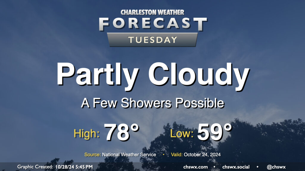
A surface trough will push inland Tuesday, and this could spread a few showers ashore throughout the day. Rain chances are pretty small, though, given the continued dry conditions, and any rain that does fall probably will not amount to a whole heck of a lot. Rain chances diminish by evening. Otherwise, expect partly cloudy skies. Temperatures will begin to trend back above normal, with upper 50s in the morning yielding to highs in the upper 70s in the afternoon.
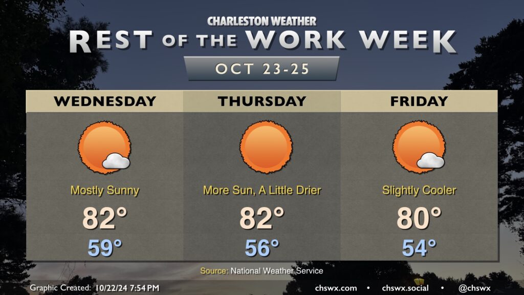
Our stretch of dry and quiet weather will continue as we close out the work week (and beyond). Generally expect lows in the 50s to yield to highs in the low 80s each afternoon with a few passing clouds from time to time. A dry front gets through Thursday, and that will send the dewpoint a little lower as well as shave a couple degrees off Friday’s temperatures. Other than that, there’s really not much to talk about. Even the tropics are quiet: there’s no named storms in the Atlantic after Oscar dissipated earlier today, and there’s no current concern for any development in the next week.
Folks looking for cooler weather should look toward the second half of the weekend into early next week as a backdoor front moves across the area late Saturday into Sunday morning. This will cause high pressure to wedge southward, and temperatures will come down several degrees from where they’ve been. We could see an increase in cloud cover and maybe even a rogue shower early next week, but otherwise, dry weather prevails.
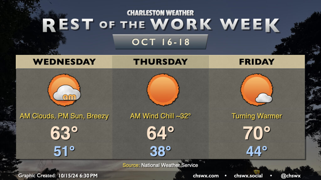
A reinforcing cold front will swing through overnight tonight, ushering in the coldest air so far this season. We’ll start the day in the low 50s, but gusty north winds will cause temperatures to struggle to the low 60s despite increasing sunshine as clouds from the frontal passage dissipate. This certainly qualifies for sweater weather in our neck of the woods — have the warm clothes at the ready!
Thursday morning will be the coldest of the set as the cool air continues to push into the area, though winds will diminish a little. Temperatures in much of the metro could dip into the upper 30s to around 40° — quite possibly the coldest morning since February 22, when it was 37°. The wind chill will be a factor (pun somewhat intended), and could make it feel close to freezing. A couple layers aren’t the worst idea heading out the door in the morning. Despite full sunshine, temperatures will still only recover to the mid-60s at best in the afternoon. This is well below normal for this point in the year (think upper 70s), and may flirt with record cold high temperatures as well (62° set in 1970).
Temperatures start to bend back toward climatology on Friday, though. We’ll start the day in the mid-40s as a bit more of an onshore component to the wind develops, heading to about 70° in the afternoon under sunny skies once again. As we get into the weekend, temperatures will continue to run a bit below normal, but mid-70s will mean short sleeves are back on the menu. With plenty of sunshine, it’ll be a solid weekend of San Diego-like weather (if you know, you know).
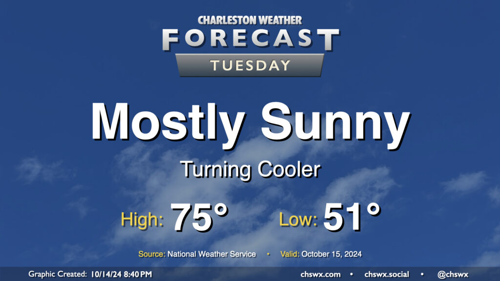
Tuesday’s temperatures, despite plenty of sunshine, will run a little below normal for this point in October. We start the day in the low 50s, warming to the mid-70s in the afternoon. Clouds will be hard to come by, though they should begin to increase after midnight. That being said, it should be another solid evening of stargazing in the western sky as Comet Tsuchinshan–ATLAS continues to appear in the night sky after sunset.
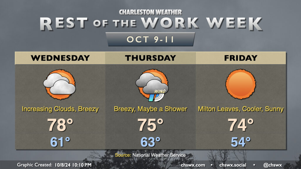
Clouds will increase on Wednesday as Hurricane Milton draws closer to landfall in Florida. We’ll see a decent northeasterly breeze during the day, but nothing unmanageable, and we’ll stay out of the rain, too. The day starts on a fairly cool note with lows in the low 60s, and we’ll warm to the upper 70s in the afternoon, tempered by the northeasterly winds and the increasing cloud cover. There will be a chance for some minor coastal flooding a couple hours around the 12:41 PM high tide, and a Coastal Flood Advisory is possible.
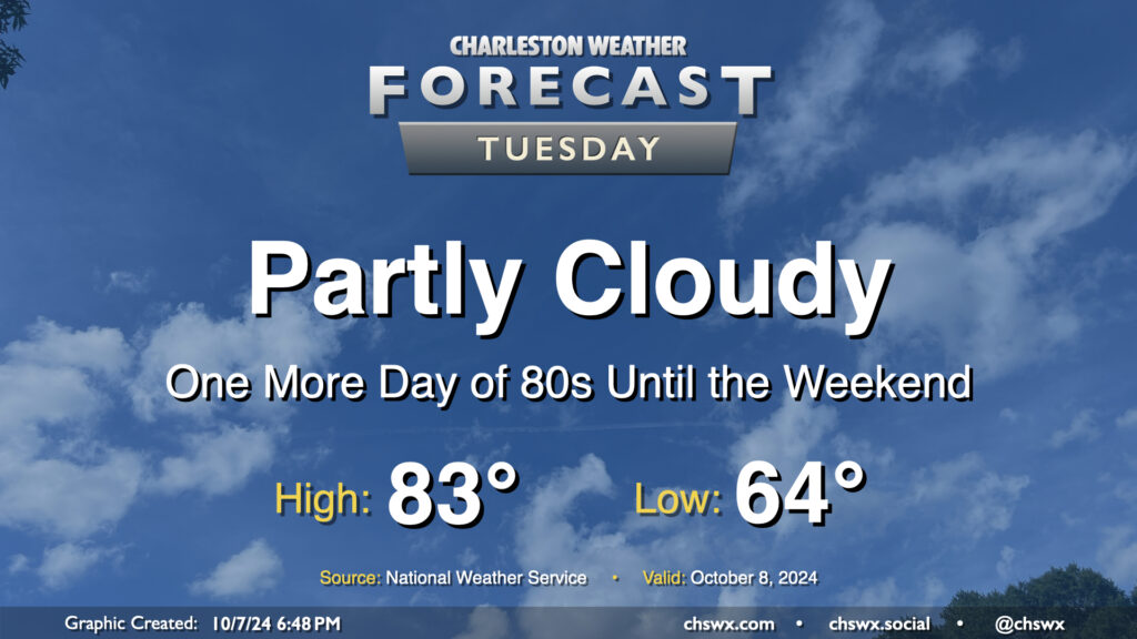
Quiet and warm weather continues Tuesday as we continue to monitor Hurricane Milton in the Gulf of Mexico for possible peripheral impacts on the Lowcountry as we get into Wednesday night and Thursday. Expect a comfortable start in the mid-60s on Tuesday, with temperatures warming to the low-to-mid-80s in the afternoon under partly cloudy skies (though clouds will be increasing as the day goes on). Northeast winds will generally run 10-15 MPH across the metro.
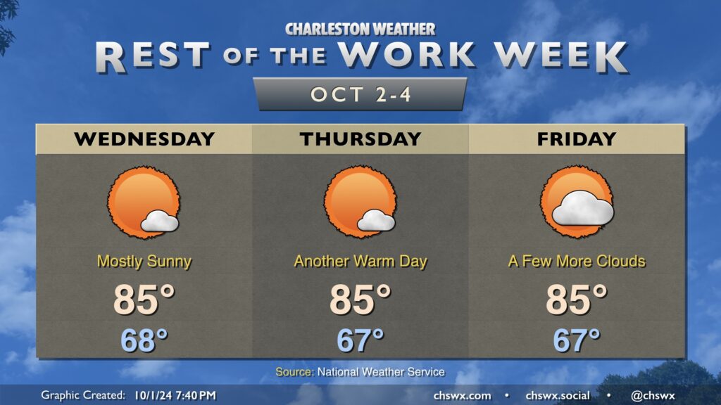
High pressure will be in control of our weather for the rest of the week both at the surface and aloft, bringing in quiet and seasonably warm conditions with a fair bit of sunshine, especially on Wednesday and Thursday. Temperatures each day start in the upper 60s, warming to the mid-80s each afternoon.
Rain chances will run essentially nil until late next weekend as a series of fronts move on by. These fronts should keep an area of low pressure in the Gulf of Mexico well to our south. While it may sling some moisture our way, any outsized impacts are not expected, and we actually have another round of slightly cooler and quieter weather expected by the middle of next week.
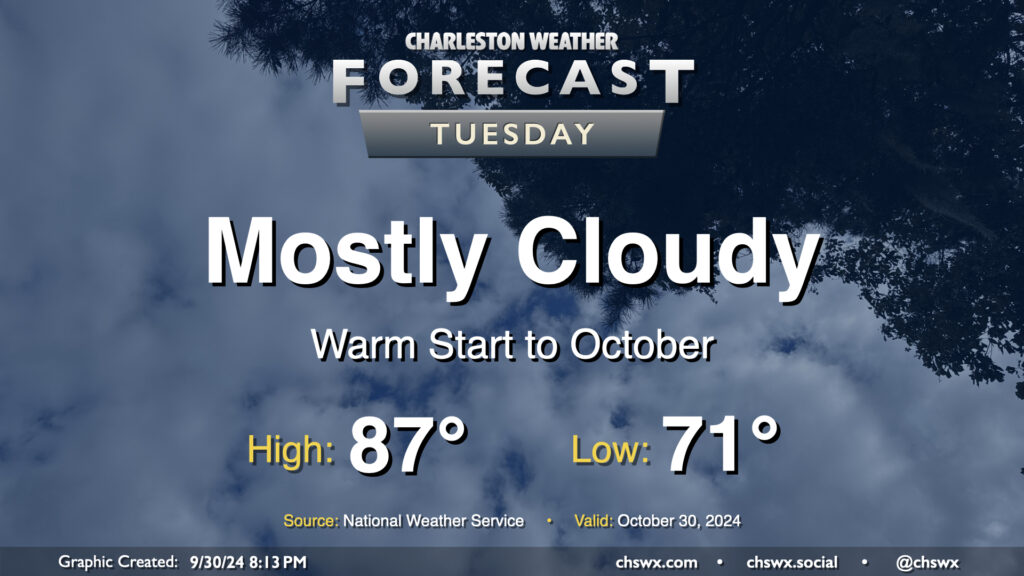
We’ll get October off to a warm but somewhat cloudy start before a cold front starts to regulate temperatures a bit more beginning Wednesday. We start the day rather mild for this time of year once again, with low 70s generally across the metro (and warmer toward the coast). Cloud cover does persist, but despite that, we’ll still warm into the upper 80s. Rain is not expected.
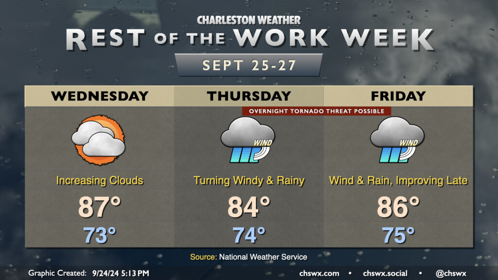
The rest of the work week will make you not want to hear the name “Helene” for a little while after it’s all over. We have one more day before wind and rain associated with the tropical storm arrive in the Lowcountry on Wednesday; it’ll be a warm and muggy day, but your last best opportunity to bring some loose things inside just to be safe. Temperatures start in the low-to-mid-70s, warming to the mid-to-upper 80s in the afternoon despite the increasing cloud cover. A few showers can’t be ruled out very late in the day, but the better chances for rain begin on Thursday.
On the current track, Helene will make landfall Thursday night in the Big Bend area of Florida as a major hurricane. It’ll be moving at a pretty decent forward speed, which should spread increasing showers and maybe thunderstorms into the area throughout the day Thursday. Helene’s impacts look to peak Thursday night into Friday morning, with gusty winds, heavy rain bands, and possibly a few tornadoes. Yes, we’ll need y’all to have your weather alerting devices in the on and alarming position Thursday night in case a tornado warning is issued. Some coastal flooding is also possible especially around high tide as onshore winds push some storm surge into the area, though the surge threat does not appear serious at this point.
Heavy rain and the tornado threat continue into Friday morning. Helene will be making quick work to the north and northwest, though, and we should see rain and wind gradually die down as the day goes on. Winds will start to take more of a westerly tack as Helene’s circulation moves away, and that should help blunt additional coastal flooding concerns on Friday. And by the weekend, we’re Helene-free.
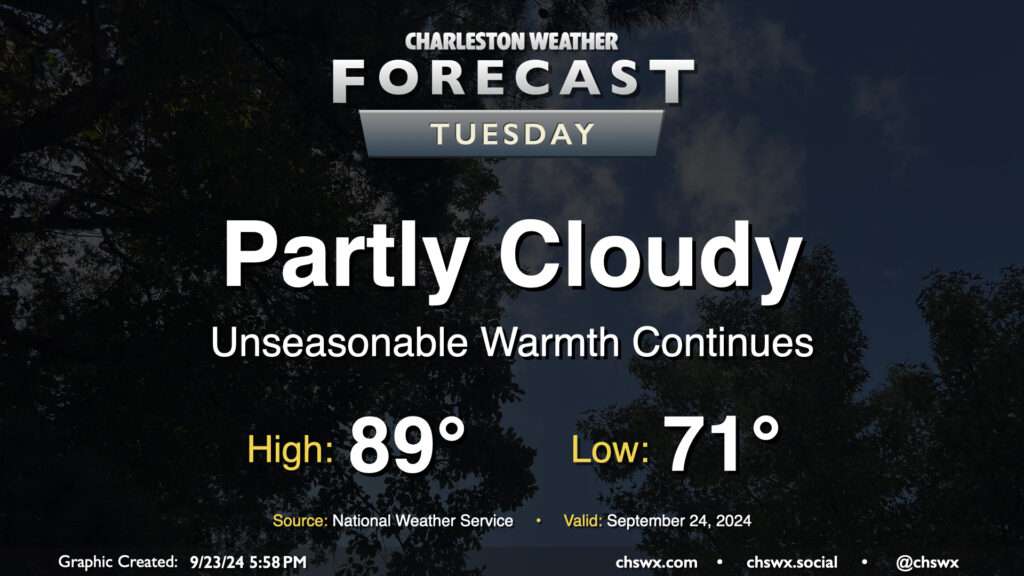
Quiet and unseasonably warm weather continues on Tuesday. Expect to start the day in the low 70s, warming to the upper 80s to around 90° in the afternoon. Dewpoints in the low 70s will yield heat indices in the mid-90s — not necessarily oppressive but certainly unpleasant considering where we are on the calendar. The ridge aloft will keep a lid on any shower activity, so no concerns there as we start to look ahead toward impacts from what is currently Potential Tropical Cyclone Nine later this week.