High pressure building in aloft will turn on the heat and keep storms at bay for the rest of the work week. After reaching 93° on Tuesday, we should reach well into the mid-90s for the next few days. Dewpoints surging back into the mid-to-upper 70s will drive heat indices back into Advisory territory possibly as early as Wednesday and more likely on Thursday and Friday. Be ready to take heat precautions once again as you head outside at the height of the afternoons.
Looking for relief from storms? Don’t count on it — the high pressure aloft will generally put a lid on much in the way of thunderstorm activity. If one can get going, then you might get some heavy rain and gusty winds, but otherwise, widespread storm activity doesn’t appear likely until next week.
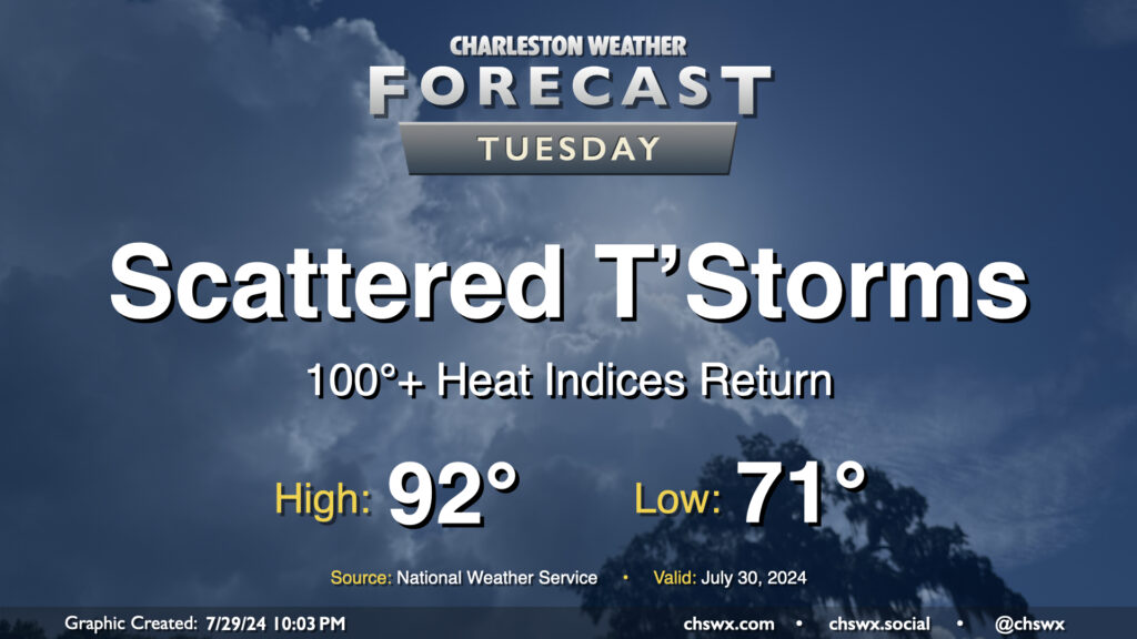
Well, the respite is decidedly over: we’re back to 100°+ heat indices on Tuesday as surface high pressure shifts offshore and higher-dewpoint air returns to the area. We start the day in the low 70s one more time, but will warm quickly into the 80s by mid-morning and should be back in the 90s by early afternoon. Dewpoints look to climb into the mid-70s throughout the day, and this will yield heat indices around 103° — hot to be sure, but shy of advisory criteria. Scattered showers and thunderstorms are primarily expected in the afternoon and evening hours, though a few showers can’t be ruled out in the morning. A few showers may try to get going on the seabreeze, but high-resolution guidance suggests that the bulk of any activity will get going perhaps in the Midlands and Upstate before dropping southeasterly into the metro. Some heavy rain is possible, and a damaging wind gust or two is not out of the question, either. Keep an ear out for possible warnings Tuesday evening, just in case.
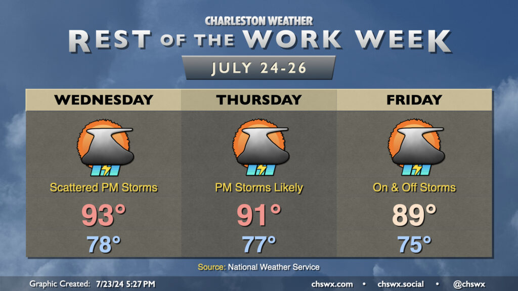
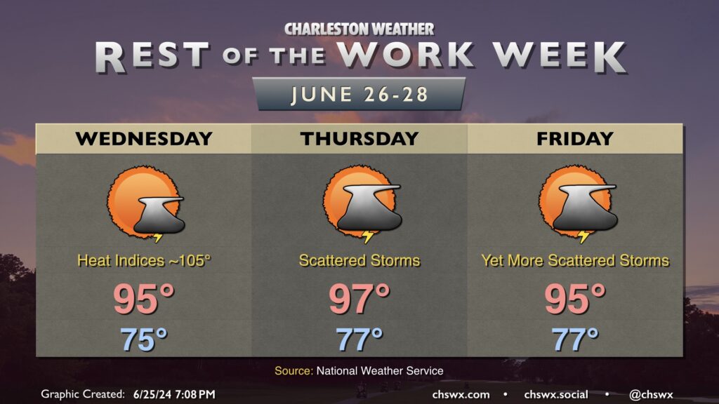
Increasing shower and thunderstorm chances will be in play each starting Wednesday as disturbances within southwest flow aloft add some lift to the generally favorable thermodynamics. Temperatures on Wednesday start in the upper 70s, warming to the low-to-mid-90s by afternoon. As far as storms, some coastal storms, perhaps with waterspouts, will again be possible with the morning land breeze. Then, once the seabreeze becomes established, we should see more in the way of shower and thunderstorm activity inland.
Rain chances tick up even further Thursday and peak Friday as a front sags south nearby. This will help keep highs capped to around if not slightly below normal, especially Friday. Both days, expect decent coverage of showers and thunderstorms especially in the afternoon and evening hours. Heavy rain and a strong storm or two can’t be totally ruled out. Friday looks particularly active with the threat for isolated flooding possible. To this end, The Weather Prediction Center has the area in a slight risk for excessive rainfall. Fingers crossed for no commute problems, but it’s something to watch.
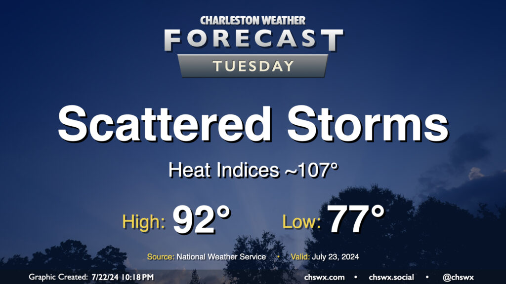
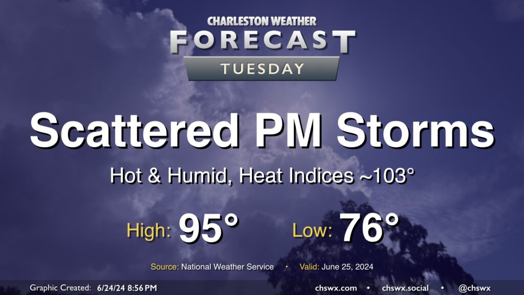
Heat and humidity will continue to rule the roost for Tuesday and for the next couple days as we stay within southerly flow at the surface and aloft, keeping the moisture pump moving right along. This will also lead to periods of storms. Guidance is hinting at another round of morning showers and storms near the coast as the land breeze develops before afternoon storms develop further inland. Coverage will generally be scattered in nature, and not all of us will see rain as a result. Highs top out in the low 90s after a start in the upper 70s; expect heat indices to get close to advisory criteria in the afternoon, perhaps approaching 107°.
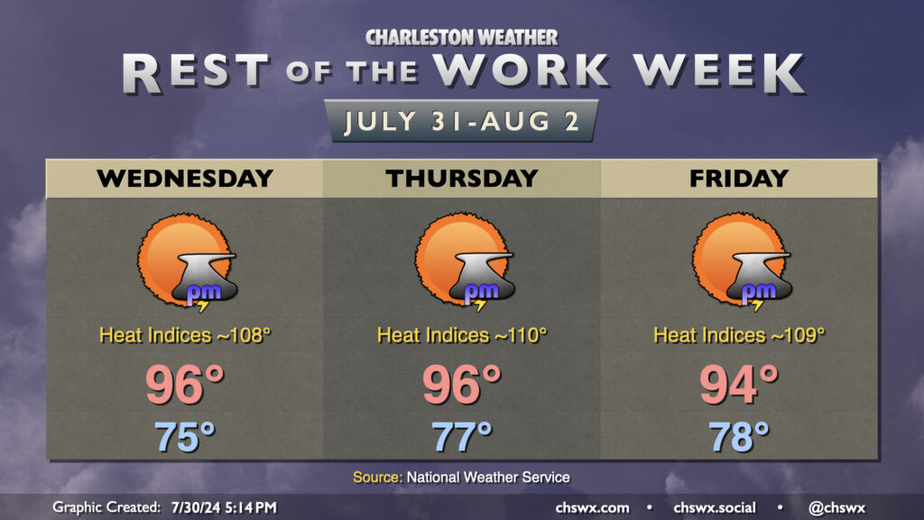
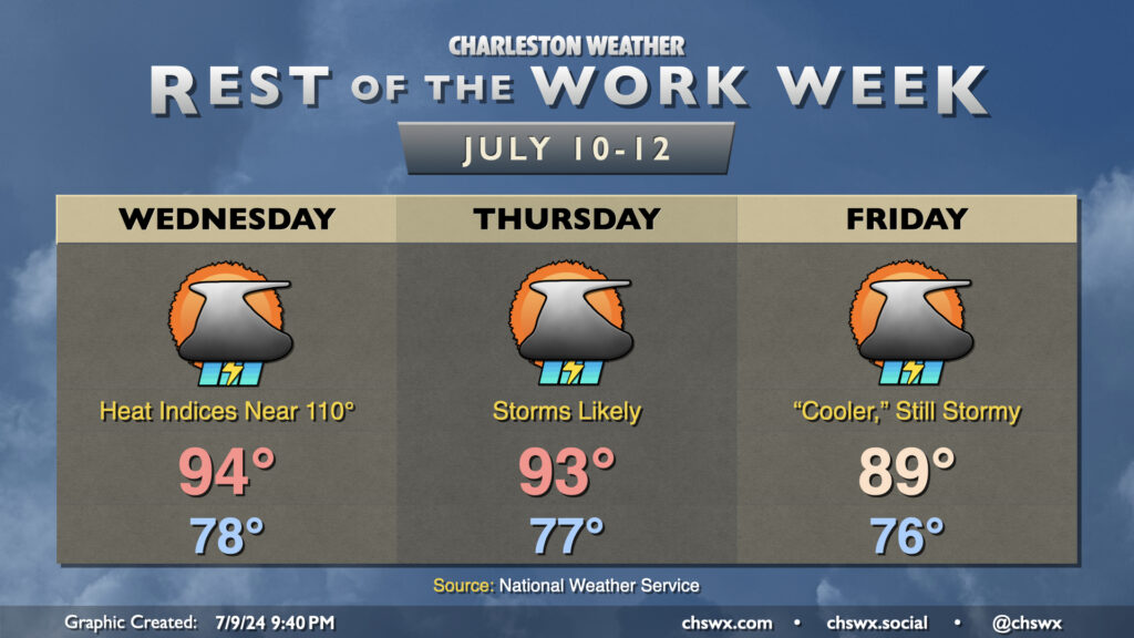
Another hot and potentially stormy day is on tap for Wednesday. We’ll start the day in steamy fashion once more, with upper 70s to start the day away from the even warmer coastline. We’ll warm to the mid-90s in the afternoon, and this combined with mid-to-upper-70s dewpoints will yield heat indices in Heat Advisory territory once again. We should see showers and thunderstorms initiate once again in the afternoon along and ahead of the seabreeze, though it’s worth noting that this evening’s convection-allowing models are showing a bit of a quieter day. We’ll see, though, as it’s often the small-scale influences that can help to drive development this time of year.
Thursday should be a little more active as a front stalls out to our west and a mid-level disturbance approaches from the east. Before storms fire, though, it’s another day in Mother Nature’s sauna with air temperatures in the low to mid-90s feeling like the mid-100s, perhaps flirting with Heat Advisory levels once again. Storms should be generally scattered to widespread in the afternoon and evening with heavy rain once again a possibility.
The aforementioned disturbance interacts with the stalled front to keep showers and storms in the area for a good bit of Friday, with coverage peaking in the climatologically favored afternoon and evening. This will keep temperatures from getting too far out of hand, with highs potentially falling short of 90° for the first time in over a week, though it’ll still be plenty warm. Heavy rain and maybe a strong storm or two remain the main concerns as we sit in a rather moisture-rich environment ahead of the stalled front to the west.
Scattered showers and thunderstorms will stay in the forecast for much of the day Tuesday. While it won’t rain all day at any one location, a shower or storm will be possible pretty much anytime especially beyond 10am. Locally heavy rainfall will be possible, but severe weather is unlikely.
We start the day in the upper 70s to low 80s at the coast, warming to the low 90s in the afternoon. Dewpoints in the upper 70s yield heat indices in the mid-100s (though just shy of advisory criteria), which will continue this stretch of uncomfortably steamy weather.
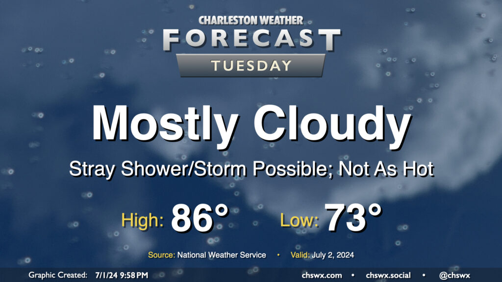
We get a brief reprieve from the heat on Tuesday as the front that brought today’s deluge nudges just south enough for a little bit of cooler and drier air to work in, especially further inland. Mostly cloudy skies will be the rule as onshore flow persists throughout the day. We start the day in the low 70s, but dewpoints sneaking briefly back into the upper 60s could feel a little bit better than we’ve felt. Those dewpoints will start to creep back up, but the cloud cover and onshore flow keeps highs capped to the mid-80s. A stray storm can’t be totally ruled out near the coast; in fact some model data suggests a few downpours will be possible before sunrise. Wait and see on that, but most of us should get Tuesday in rain-free.
Heat and humidity continue for the rest of the week, with advisory-level heat indices remaining a distinct possibility, broken up only by isolated to scattered afternoon and early evening thunderstorms.
We’re back into the mid-90s Wednesday after a mid-70s start. Heat indices in the mid-100s will be common, with higher values possible closer to the coast where dewpoints will run a little higher. Don’t be surprised if another Heat Advisory comes out for Wednesday. A few of you could get lucky and get a thunderstorm to help cool things off, though the winds could be a bit strong at times in these. However, as is common with the summertime weather regime around here, widespread severe weather is not expected.
We’ll keep this going Thursday into Friday. Air temperatures peak on Thursday, topping out in the mid-to-upper 90s as winds go a little more westerly through about 5,000 feet. Once again, isolated to scattered showers and thunderstorms are possible in the afternoon as convective temperatures are reached and the seabreeze makes a slow push inland. Expect similar conditions Friday, with highs once again topping out in the mid-90s after an upper 70s start, with just a few showers and thunderstorms perhaps imparting relief.
Another hot summer day lies ahead for Tuesday, with just a few of us possibly seeing some relief from thunderstorms in the afternoon. We start the day in the mid-70s, warming to the mid-90s in the afternoon. Dewpoints in the low to mid-70s will make it feel closer to 103° at times, with even warmer heat indices possible in the wake of the seabreeze.
As mentioned, a few thunderstorms will be possible with a stalled front in the area, but not everyone will see a storm. A stronger storm or two can never be ruled out this time of year, but there is not a widespread risk for severe weather.
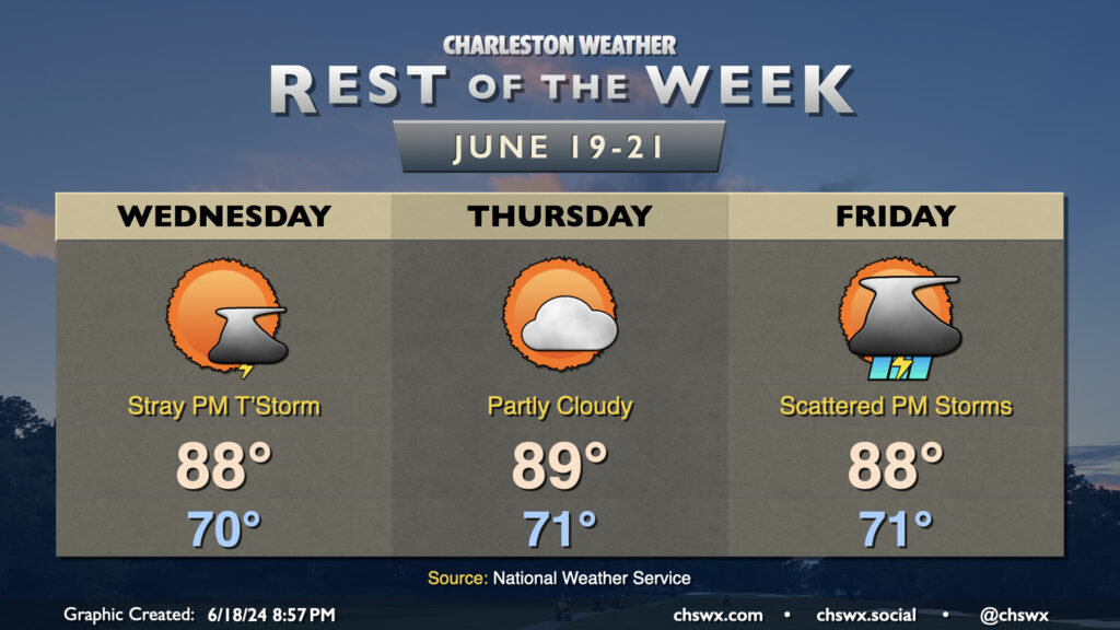
Near-normal temperatures and a few stray storms will mark Juneteenth across the Lowcountry. We start the day around 70°, warming to the upper 80s in the afternoon as onshore flow continues to keep temperatures a little lower. A few showers and maybe a thunderstorm will be possible, particularly in the afternoon, but many of us stay dry once again.
An approaching tropical wave — thankfully, of the open wave variety and nothing more organized — will be the weather feature of interest later Thursday into Friday. Ahead of the wave, we should see a mostly quiet day of weather with temperatures near normal and partly cloudy skies. Rain chances tick up Friday as the wave comes ashore, with scattered showers and thunderstorms a decent bet. It won’t rain all day at any one location, though. Temperatures Friday will be limited to the upper 80s with the shower and thunderstorm activity. We’ll start to get much warmer this weekend, with highs returning to the low to mid-90s well into next week.