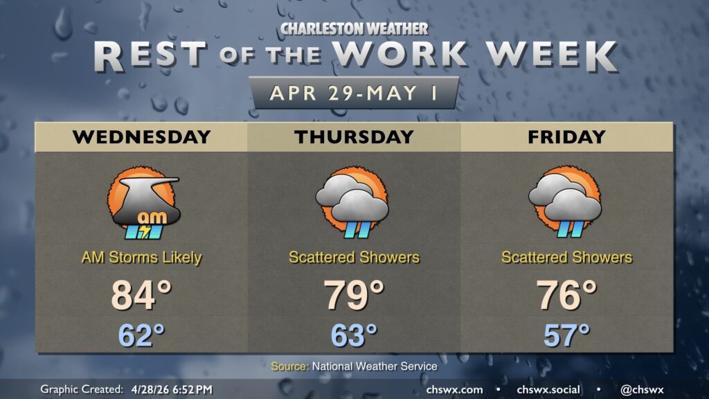
We will close a bone-dry April out with a couple more chances for showers and thunderstorms as another cold front approaches the area with disturbances riding along it. One such disturbance fell apart as it reached the Lowcountry today, giving us another trace of rain at the airport. Officially, though, rainfall totals for the month of April remain at 0.01”, which currently ties 1972 as the driest April on record. With any luck, though, we should not end up there, though a top-five driest April on record certainly appears to be in the cards.
High temperatures return to the 80s on Wednesday as high pressure begins to move out into the Atlantic. This is the continuation of a warming trend that will last into the weekend, which will feature temperatures returning to the mid-to-upper 80s ahead of a front that will bring the first decent chance of rain in a couple weeks.
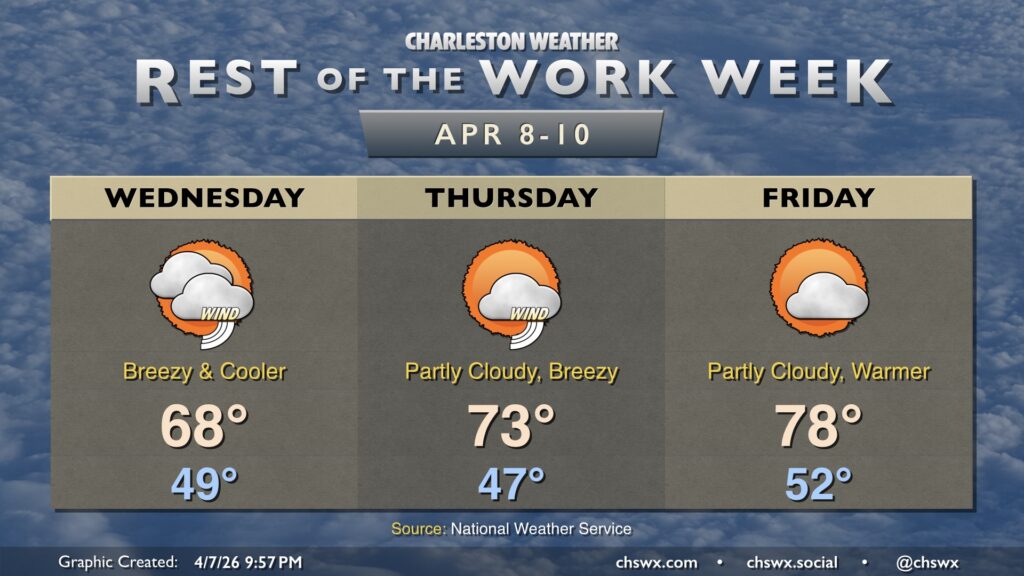
High pressure remains the main weather driver for the rest of the work week, keeping things generally quiet but also warm and dry — not great for the ongoing drought. Temperatures Wednesday will take another jump into the mid-80s across the area away from the locally cooler coastline with plenty of sunshine after some patches of morning fog. A disturbance aloft will cause an uptick in cloud cover for Thursday and keep temperatures close to Wednesday’s values, but it’ll still be plenty warm and well above normal for this point in the year.
The warmest period begins Friday and lasts until Saturday, in which high pressure anchored to our south drives more westerly wind trajectories at the surface and aloft. This will send temperatures to near record levels Friday, with highs in the low 90s a distinct possibility under mostly sunny skies.
Stacked high pressure remains in control for Tuesday, yielding plenty of sunshine and a continuation of our warming trend. We’ll start Tuesday in the upper 50s to low 60s, warming to the mid-80s away from the coast. Expect downtown to peak in the upper 70s, while we may not get out of the upper 60s right at the beaches where the adjacent Atlantic waters continue to run in the upper 60s.
A reinforcing front will push through tonight, bringing us cooler and breezy weather for Wednesday. We start Hump Day in the upper 40s to around 50°, warming to just the upper 60s in the afternoon with a mix of sun and clouds. It’s going to be a breezy day, too, with winds 15-20 MPH gusting to 30-35 MPH. This combined with dry air will increase the fire danger for Wednesday. The northeasterly winds also increase the rip current and high surf risk, with a High Surf Advisory in effect for Wednesday into much of Thursday.
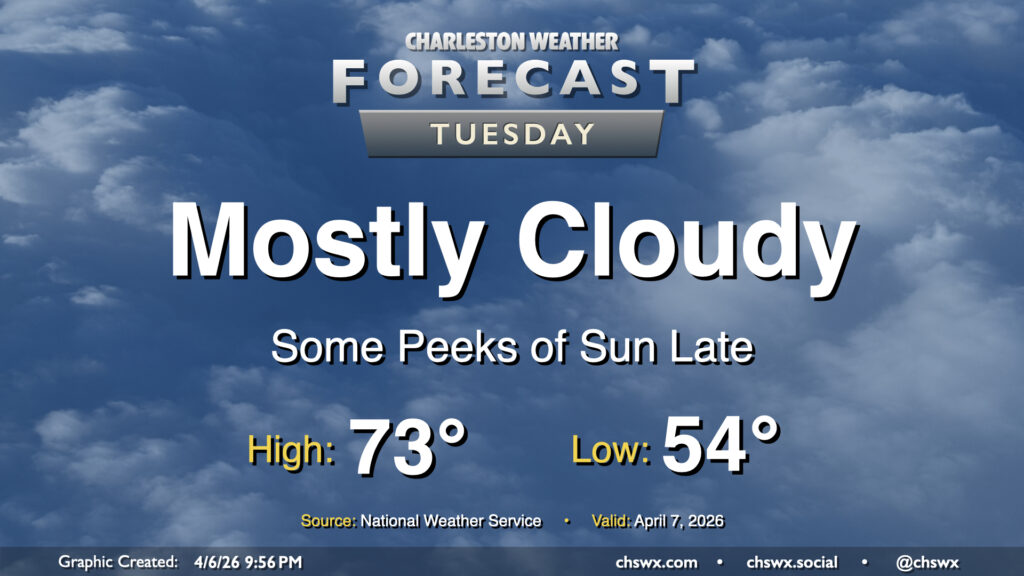
Cool high pressure remains the primary weather driver on Tuesday, though temperatures may tick up a degree or two compared to Monday’s high of 69°. We’ll keep the clouds around for a majority of the day, though some peeks of sun should start to filter through later in the day. Generally, expect to start the day in the mid-50s, warming to the low 70s in the afternoon. Northeasterly winds will kick up a little bit throughout the day, with gusts around 20-25 MPH possible.
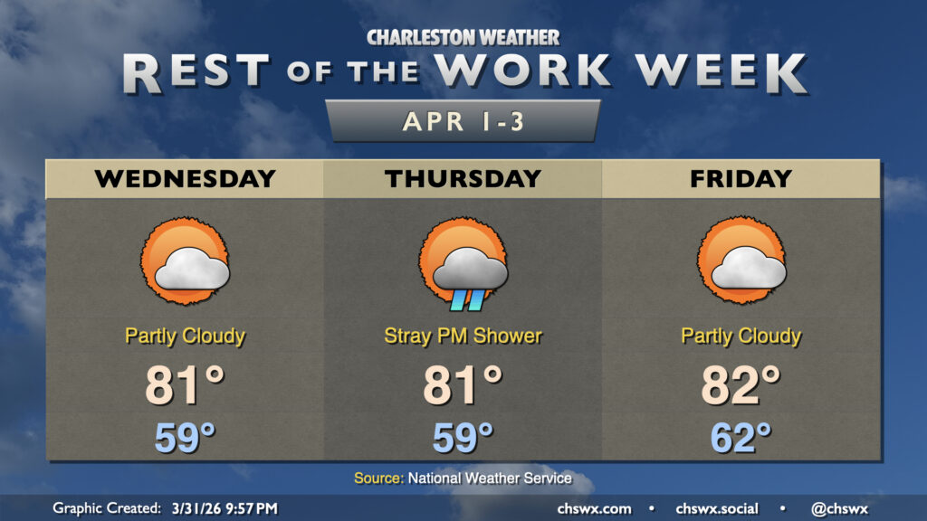
April gets off to a seasonably warm start with temperatures running in the low 80s and lows in the upper 50s to low 60s each morning. High pressure at the surface and aloft remain the main weather drivers, which will keep things generally on the quiet side for the next few days. The only notable rain chance for the rest of the work week arrives Thursday with a bit of upper-level energy working through, but even then the chance for a shower is fairly slight at this point, so don’t look to it for any widespread drought relief.
We may see an uptick in shower chances especially heading into Sunday, but there still doesn’t seem to be much on the horizon right now to tamp down on the ongoing (and worsening) drought.
After a couple cooler days, the 80s return to the Lowcountry starting Tuesday and lasting well into the beginning of April. High pressure remains the main weather feature, keeping us generally on the quiet side. A southerly breeze around 5-10 MPH will be common, especially as we get into the afternoon. Thankfully, some higher dewpoints will also continue to put a dent in the fire danger.
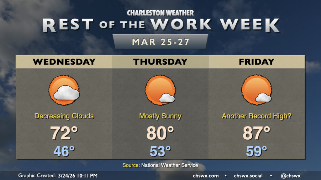
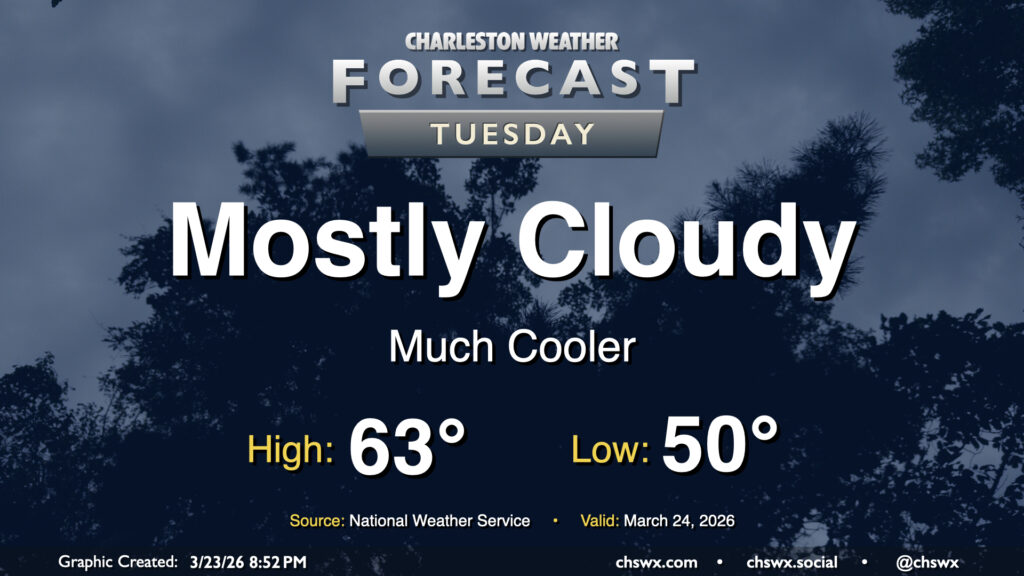
As expected, Tuesday was quite the dreary, cool day. We set the daily highs at both downtown and North Charleston after midnight, with the preliminary daily low of 53° being set in the afternoon as of the 5PM climate report. (This will get cooler — as of this writing, it’s 52° at the airport.) We begin to see signs of recovery on Wednesday, though, as the high pressure wedge weakens and scours out, allowing progressively more sunshine through during the day. Expect lows in the mid-40s to warm to the low 70s in the afternoon — basically right on target for this point in the year.
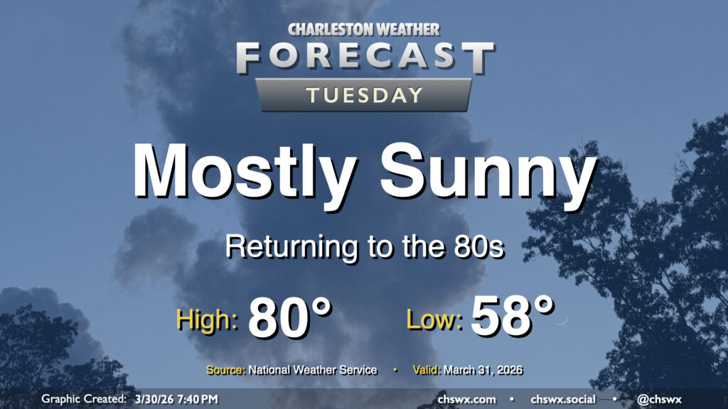
Tuesday could be quite a shock to the system after Monday’s record warmth. We’ll go from a high of 90° on Monday, which was not only a daily record high but the fourth earliest 90° day on record, to a high in the low 60s on Tuesday with mostly cloudy skies in the wake of a cold front that is entering the Tri-County area as of this writing. No rain is expected, but we can expect breezy northeasterly winds as a cold air damming regime takes hold, at least briefly.