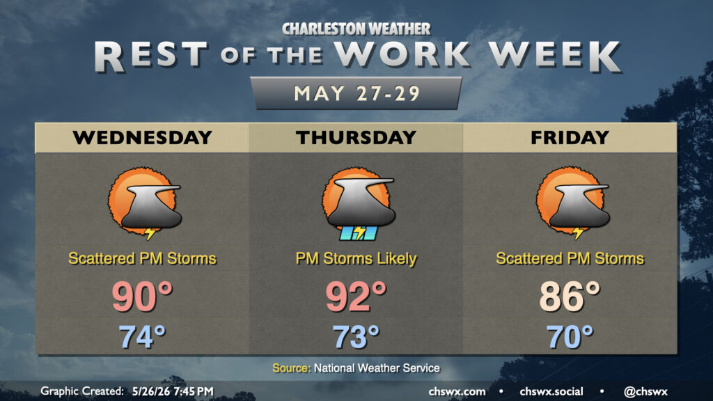
Unsettled weather sticks around for the rest of the work week as disturbances continue to move across the area, with a shot of tropical moisture enhancing rainfall heading into the weekend.
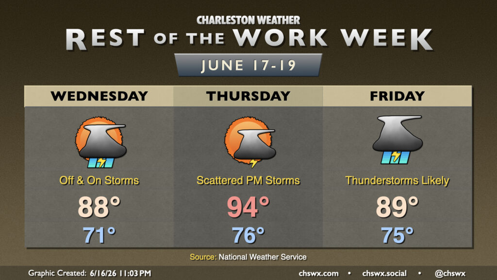
Heat and humidity will continue to build as we head down the home stretch of the work week. We’ll also start to see an uptick in shower and thunderstorm chances as well, which should bring at least a little relief.
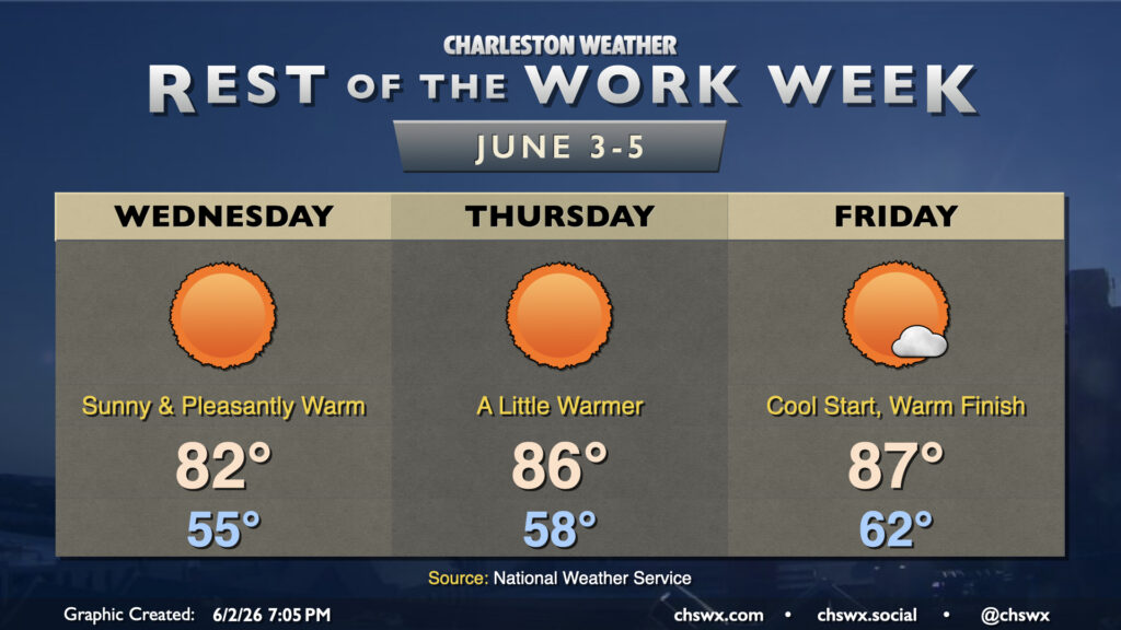
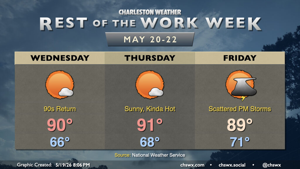
Rain is done for a few days as dry high pressure builds down into the area, bringing about comfortable warmth as we get down the home stretch of the work week. It won’t feel like June on Wednesday as temperatures bottom out into the mid-50s away from the locally warmer coastline. Expect highs to peak in the low 80s in the afternoon with nearly unfettered sunshine as deep dry air sets in. Savor the low humidity because we don’t have too many more days like this left for a while!
If the beach is in your plans, be aware of a high risk of rip currents during the day Wednesday due to the ongoing northeast flow. It’s best to stay out of the water on days like this
We should see another scattering of showers and thunderstorms on Tuesday in association with a cold front that will make for a rather nice second half of the work week. Temperatures will start in the mid-to-upper 60s, warming to just about 80° in the afternoon as the front pushes further southward and drier air begins to find its way in. Dewpoints should fall nicely late Tuesday into Wednesday, setting up a stretch of spring-like conditions through Friday.
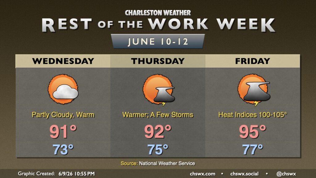
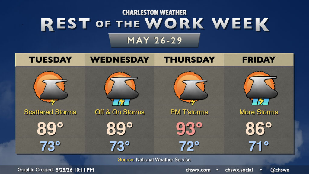
More opportunities for much-needed rainfall will continue for the rest of the work week and beyond as a front approaches the area and stalls out. Warm and muggy conditions will be a mainstay as well, especially Wednesday and Thursday.
Unsettled weather will continue for the rest of the abbreviated work week as we remain on the periphery of Atlantic high pressure, with plenty of moisture available for the seabreeze and other boundaries to kick off showers and thunderstorms each day. Some much-needed rain will fall, and those chances will improve heading into next weekend.
High pressure at the surface and aloft along with plenty of sunshine will help bring the 90s back to the Lowcountry over the next few days for the first time since mid-April. Dewpoints will not quite head back to those summertime 70s just yet, thankfully, so heat indices will remain in check, but it’ll still be plenty warm and a harbinger of things to come as we head toward June.
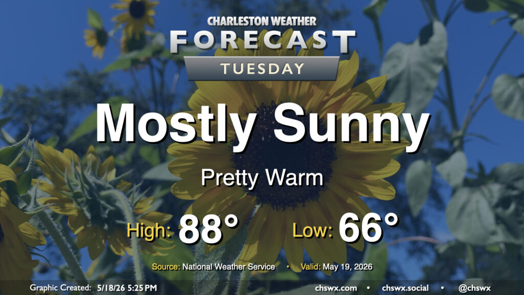
More sunshine is in the offing for Tuesday with high pressure in continued control of our weather. The air will have a bit of an early summer feel to it with lows bottoming out in the mid-60s, warming to the upper 80s and perhaps approaching 90° in the afternoon. Dewpoints will mix down to the mid-60s in the afternoon, so while it won’t be excruciatingly humid, there will definitely be a bit more heaviness to the air, so to speak.
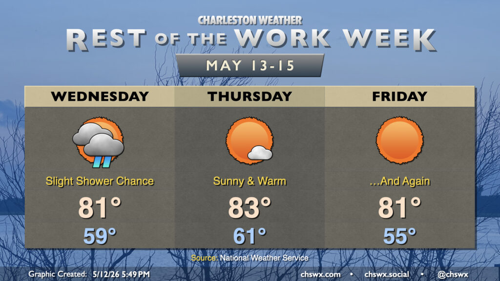
Generally quiet weather will be the rule for the rest of the work week as dry high pressure builds in from the northwest, keeping temperatures near mid-May norms.
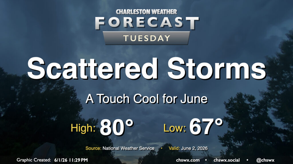
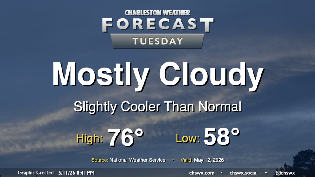
High pressure nudging in from the north will keep cloud cover in place and cool us off a bit for Tuesday after the third 90° day of the year on Monday. We’ll start the day in the upper 50s, warming to about the mid-70s given the expected cloud cover. A shower could get close to far southern Charleston County during the day, but most of us should stay rain-free.