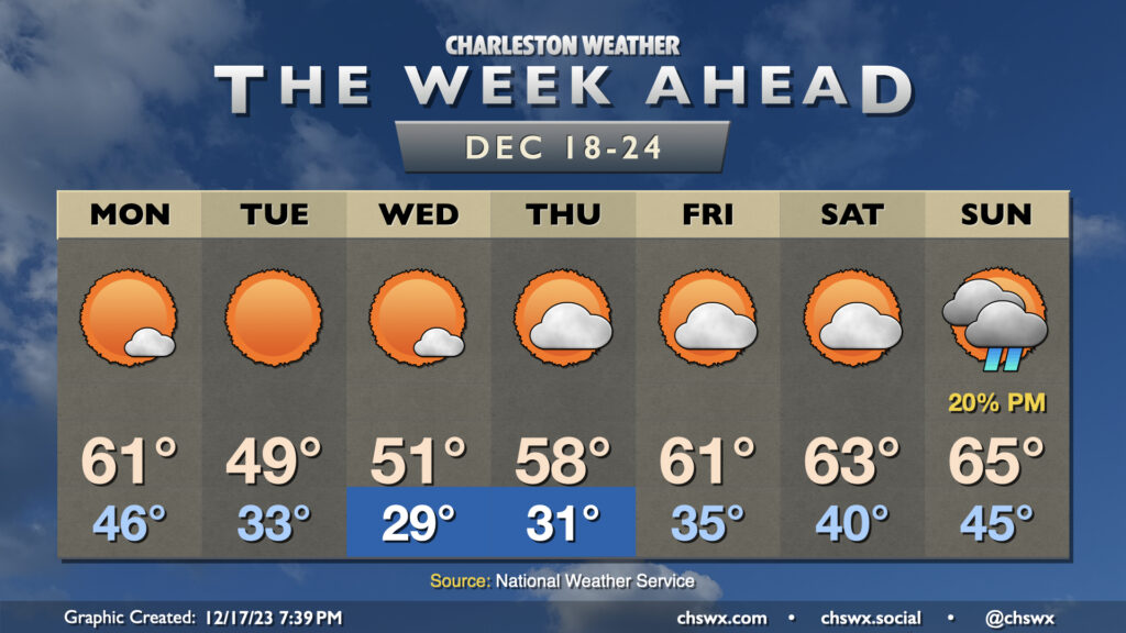
After a record-breaking — historic is not hyperbole in this case, frankly — day of weather, we’ll turn back to more tranquil — and for a few days, quite cold — conditions as we head into the final shopping week before Christmas.
Monday will feature temperatures generally in the ballpark of normal, but a strong (but dry) cold front will clear the area late Monday into early Tuesday, shifting winds to the northwest and turning on the chill as high pressure builds in from the west. Expect to start Tuesday very near freezing in the metro area, and likely at or below freezing further inland. Despite sunny skies, strong cold advection should keep temperatures below 50° in the afternoon. (Brrr.) A solid freeze looks to set up for Tuesday night into Wednesday morning, with lows in the 20s across much of the area as high pressure settles in overhead. Highs on Wednesday get to about 50-51° or so with a few clouds at most.
After another freeze Thursday morning, high pressure will slip offshore and temperatures will begin to recover into the upper 50s to low 60s to close out the week. We’ll keep an eye on Christmas weekend for our next storm system, but the usual model disagreements are sufficient enough where any confidence in any rain is pretty low.
A cold front getting through overnight Sunday will clear the area by daybreak Monday, ushering in much cooler and drier air and setting up a week of below-normal temperatures. Clouds will be scouring out Monday morning, yielding abundant sunshine, but cold advection will keep temperatures capped to the mid-to-upper 50s in the afternoon.
Tuesday morning will start in the mid-30s — about 10° cooler than Monday morning — and could dip into freezing territory further inland. Highs will run a touch warmer, but only in the upper 50s to around 60° under mostly sunny skies. Temperatures moderate a little more on Wednesday before a reinforcing cold front swings through, sending Thursday’s highs down to the mid-50s with an increase in cloud cover, though dry air will preclude any rain with this front. Highs in the 50s continue to close out the work week.
As we get into the weekend, we warm up some, but the weather may turn unsettled once again as a coastal trough may develop with assistance from a storm system in the Gulf. It seems 2023 wants to go out the way it came in — with a continuous pattern of unsettled weekends. Not cool, 2023.
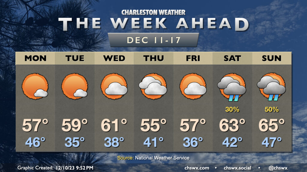
After a weekend in which clouds were prevalent but rain perhaps not so much, we get into a mostly quiet week ahead despite a few frontal passages that will gradually cool us off as we move through the week.
After a very chilly and raw Sunday in which the high temperature didn’t (as of this writing, anyway) reach 50°, temperatures make a brief rebound for Monday in the wake of a front as high pressure builds in. Diminishing cloud cover and northwesterly winds will help temperatures rebound to the low 60s on Monday, which will feel positively wonderful. Temperatures will then drop into the upper 30s for Tuesday morning as the cooler high pressure begins to settle in over the area. Temperatures will only reach the mid-50s on Tuesday despite ample sunshine. Radiational cooling conditions improve tremendously as winds go light and skies go clear Tuesday night into Wednesday morning, and this will allow temperatures to get down to freezing for the first time this season in many spots in the metro, particularly inland. Highs will head to the mid-50s once again with full sunshine.
From there, high pressure begins to move away, turning nature’s heat pump back on as winds go more southerly. We’ll get off to another frosty start Thursday morning before warming to the low 60s in the afternoon. Friday will be even warmer, with lows in the mid-40s (closer to normal for this point in the year) and highs in the low 70s in the afternoon. We’ll keep this warmer weather going into the weekend, with lows well above normal for Saturday and Sunday, albeit with some shower chances as mid-level disturbances swing through from time to time.
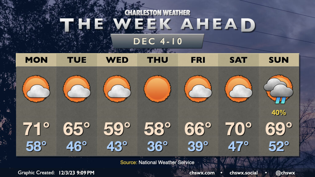
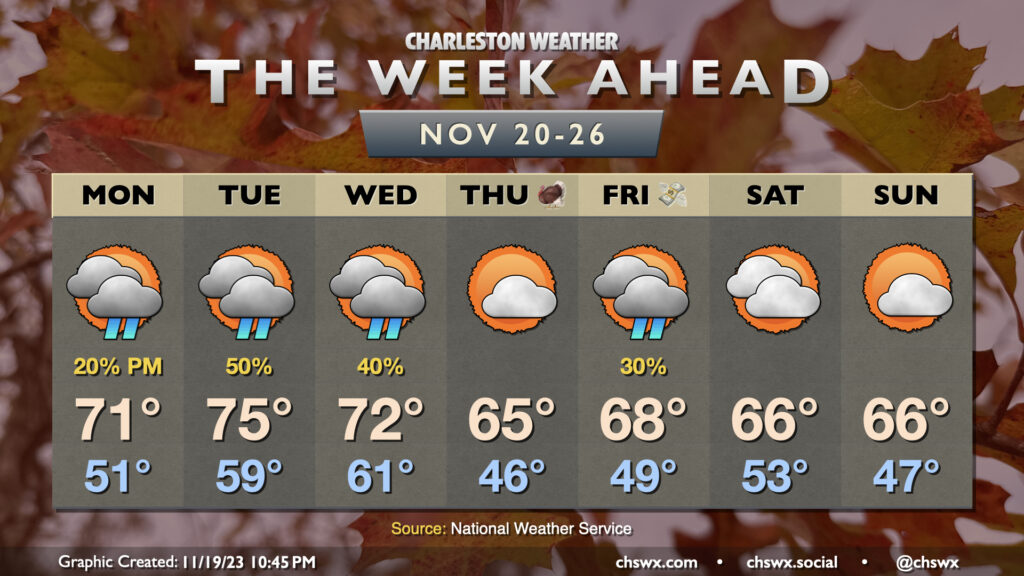
The week ahead will be unsettled at times as a couple disturbances, including a reasonably strong cold front, come by this week, which will bring more beneficial rain to the area (and maybe even a few rumbles of thunder).
After a dreary weekend, some sun begins to peek back out for Monday, and this will help temperatures get closer to — but still a touch below — mid-November norms. Expect highs in the mid-to-upper 60s Monday through Wednesday, with high temperatures reaching the low 70s starting Thursday and continuing into the weekend, with a slight cooldown for Sunday in the wake of a weak cold front.
Clouds will steadily increase through the first part of the work week as a reasonably vigorous disturbance ejects out of the southern Plains, with surface low pressure moving southeast from the Gulf Coast toward the Florida peninsula, dragging an inverted trough to its north that will help be a forcing mechanism for some shower activity here at home. There’s a slight chance of showers as soon as Wednesday, with rain chances peaking Thursday before gradually tapering Friday and perhaps into Saturday depending on the timing of the trough’s exit and the aforementioned front crossing the area. Most of Saturday should be rather nice, and Sunday will offer even more in the way of sunshine.
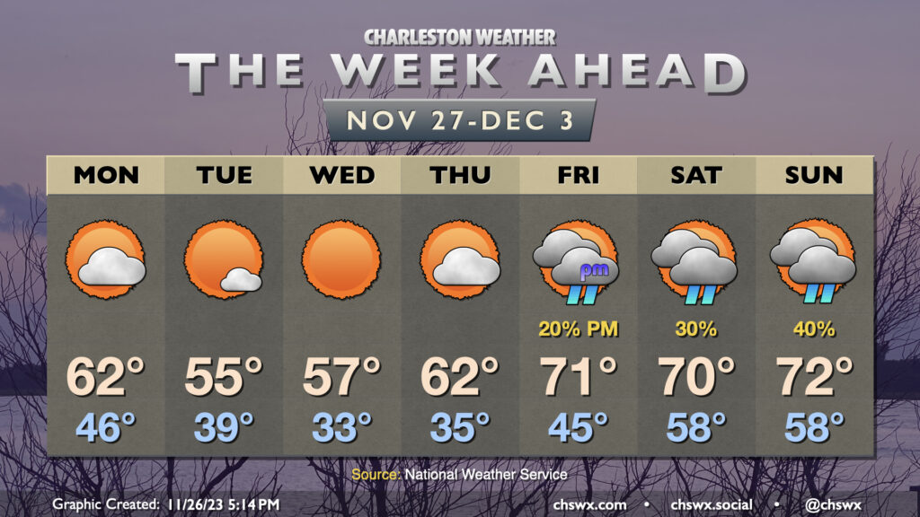
The warming trend that began this past weekend continues for much of the upcoming week, but a front will bring along some cooler air — and maybe a few showers — as we head into the weekend.
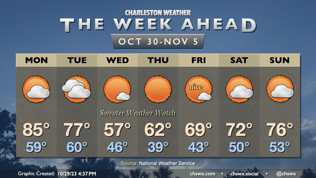
The week ahead will feature the strongest cold snap of the season thus far sandwiched between a warm start and a warm finish. It’s a classic “shorts then sweaters” week of fall weather in the Lowcountry as a strong front moves by late on Halloween.
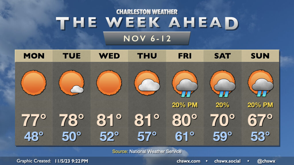
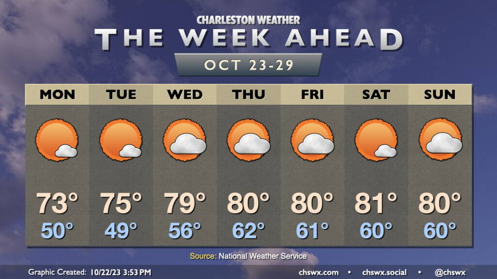
The story of this week’s weather will be high pressure keeping a firm grasp on the area for the rest of the week (and maybe even the rest of October). This will lead to generally quiet weather, with a warming trend bringing us into the low 80s starting around midweek. Monday will be the coolest of the set in the wake of a dry cold frontal passage; we start the day around 50° and warm into the low 70s in the afternoon with just a few clouds. Tuesday starts a touch cooler, but the warming trend will begin with temperatures reaching a little warmer in the afternoon. A decent stretch of above-normal warmth takes hold from there, with variable cloud cover but little else to write home about as moisture is generally scant. All in all, it’s not a bad week to get the car washed (note to self) and enjoy some outdoor lunches.
The only concern may end up being coastal flooding at times of high tide possibly starting as early as Tuesday. Winds will be out of the northeast as high pressure settles in to our northwest, and this combined with the upcoming full moon will once again start to send water levels above coastal flood criteria as we head into the latter half of the week. Keep an ear out for Coastal Flood Advisories from the National Weather Service.
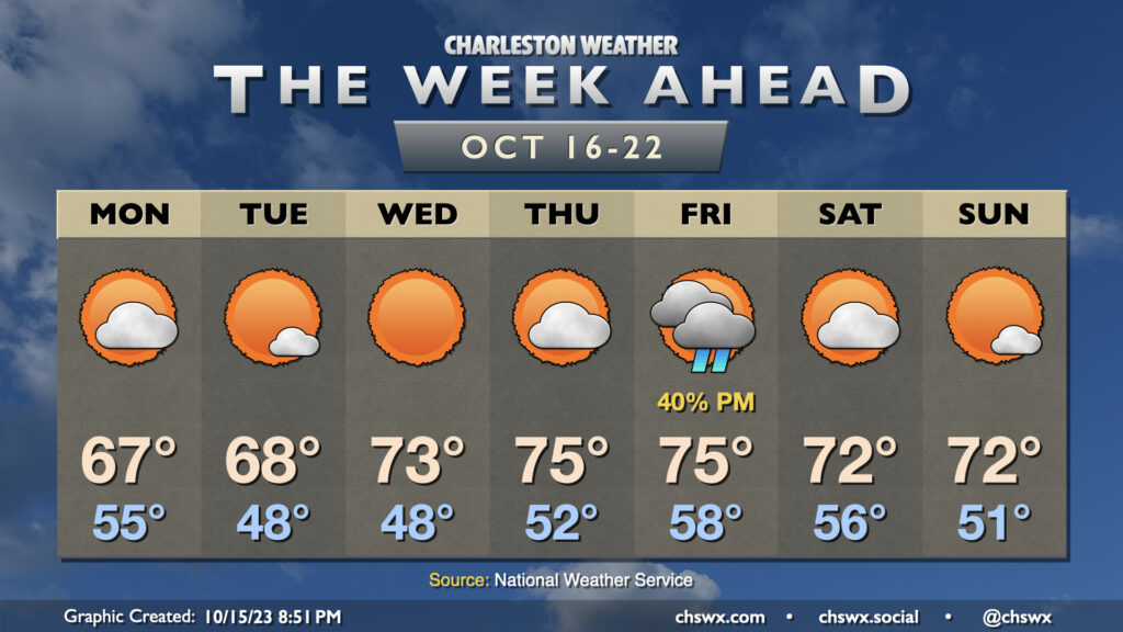
Overall, we’ve got a pretty nice week ahead with temperatures running generally below normal and only one passing rain chance on Friday.
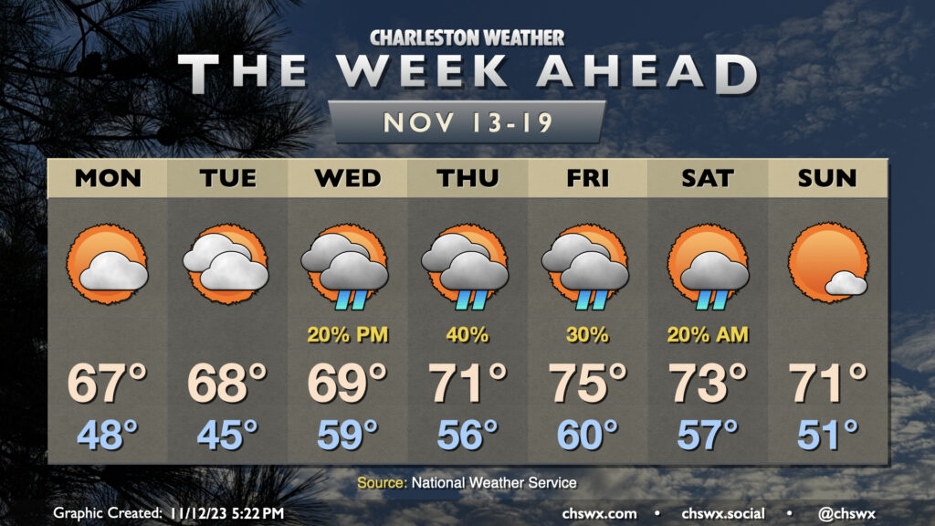
A trough moving by overnight Sunday into Monday could bring a few showers early Monday morning, but those will be done by daybreak, and we should see a partly cloudy day with highs topping out only in the mid-to-upper 60s, some 10° below normal for this point in the year. (Might be a little taste of sweater weather?) We start Tuesday in the upper 40s with highs once again peaking shy of 70° with more sunshine expected. We have a similarly cool start Wednesday but with unfettered sunshine, expect highs to top out in the low 70s. Thursday runs a little warmer with lows starting in the low 50s and highs in the mid-70s with a little bit more in the way of cloud cover (but still plenty of sun, too).
Our only real rain chance this week arrives ahead of a cold front on Friday. Generally, expect a scattering of showers in the afternoon and evening ahead of the front, but nothing too outrageous. Highs will run in the mid-70s. Behind the front, a modest cooldown will ensue, but it should be a really nice weekend with lows in the 50s and highs in the low 70s each afternoon.