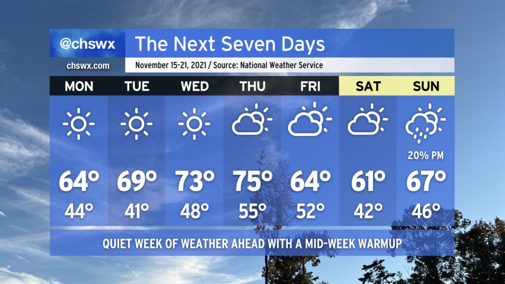
We’ve got a quiet weather week ahead thanks to high pressure and dry air, especially in the first part of the week. Monday gets us off to a cool start, with lows in the mid-40s in the metro only warming to around 64-65° in the afternoon despite full, uninterrupted sunshine. We keep mostly sunny skies in play through Wednesday as high pressure slips offshore, allowing temperatures to warm up into the low 70s by mid-week. A reinforcing shot of cool air arrives Friday with a dry cold front, knocking temperatures back into the 60s for the weekend. A shower or two could pop on Sunday as high pressure wedges southwestward across the area and a coastal trough develops, but it’s certainly not enough to cancel any plans. Enjoy it — it’s hard to believe that we’re just a little over a week out from Thanksgiving at this point!
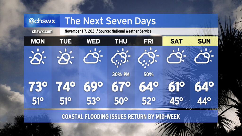
After a tumultuous weekend of coastal flooding, wind, record-low maximum temperatures, and rain, the week ahead offers a nice respite. We’ll start the week chilly, with lows in the 30s away from the immediate coast warming to the mid-60s for Monday. The 70s return for a few days thereafter, with mostly fair weather until a cold front approaches the area late Thursday into Friday, bringing rain chances back into the picture for Friday and perhaps parts of Saturday. Don’t let the sweaters get too far out of reach, though: by Sunday, we’ll be feeling quite a cooldown as highs struggle to reach 60° despite partly cloudy skies.
A coastal flooding threat continues with the Monday morning high tide, which could again approach moderate coastal flood thresholds (7.5’ mean lower low water). High tide is forecast to peak around 10:32am. What’s a few more road closures after this insane weekend of flooding, in which we reached 8’ tides three times, including setting the 10th and 11th highest water levels on record at Charleston Harbor? The good news is that the coastal flood threat winds down thereafter as astronomical influences wane and offshore winds continue.
If the random few shots of cool weather in the past few weeks haven’t gotten you to extract your fall attire just yet, you’re going to want to get on that by the end of this week as prolonged below-normal temperatures are in the cards. Indeed, the air is going to take on quite a November feel (though one more characteristic of late November than the beginning) by the weekend. While you’re grabbing the sweaters, though, you might want to reach for the waders, as well, with moderate to major salt water flooding possible around times of high tide by the end of the week.
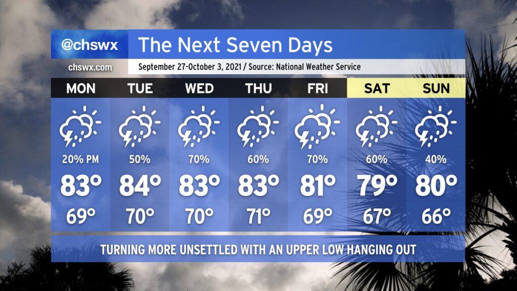
We’ll see a little more of an unsettled pattern going into this week with plenty of temperature peaks and valleys to close October. Monday looks to begin with rain overspreading the area in response to an area of low pressure developing offshore, making for a wet morning commute with some rumbles of thunder possible especially near the coast. Overall rain amounts shouldn’t be terribly heavy, but watch for some slick roads nonetheless as much of the area hasn’t received rain for the better part of two weeks.
A cold front swings through late Monday, bringing with it a slight chance for showers and thunderstorms in the afternoon and evening hours. Thereafter, we will see a nice little cooldown for Tuesday and Wednesday with quiet weather expected. Lows Wednesday morning look to dip into the lower 50s.
We’ll be dealing with a pretty potent storm system heading into Thursday and Friday as a strong upper low digs southward toward the Gulf Coast and brings a cold front with it. Showers and thunderstorms — with a couple stronger storms not out of the question — look to come into the area primarily Thursday afternoon through Friday morning. Temperatures on Thursday peak in the mid-70s and the low 70s on Friday as clouds and maybe a shower or two persist through the rest of the day.
After the front passes through, we’ll get another shot of autumn-appropriate air for the weekend. Lows will flirt with 50° and lower with highs not even reaching 70° on Saturday under partly cloudy skies. Seasonable weather continues for Sunday — solid weather for costumed candy acquisition activities.
Expect a relatively tame week of weather as a series of high pressure systems transit through the area. We’ll get Monday off to the chilliest start since we bottomed out at 49° on May 15 as widespread 40s are expected under clear skies. Much like today, temperatures will rise back into the low 70s for the afternoon, making for a rather delightful day (weather-wise, at least.)
A warming trend commences Tuesday into midweek as high pressure moves over the area and eventually offshore, allowing temperatures to return to the 80s by Thursday. A dearth of moisture, though, will keep these above-normal temperatures feeling quite alright. A cold front comes through sometime late Friday into Saturday, allowing another area of cooler high pressure to build back in.
It’s a rare week of little to no weather worries: tides remain in check, the tropics are quiet, and we look to stay mostly rain free (unless Friday’s front can squeeze out a shower or two). We’ll have a good mix of cooler and warmer temperatures — really, a little something for everyone. Enjoy it!
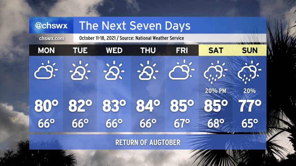
The upcoming week looks much more rain-free than the past week was, as ridging aloft builds across the area. Said ridging will drive temperatures up toward “Augtober” levels by the end of the week — mid to upper 80s will be possible, challenging record highs — but the good news is that humidity will remain tolerable. Monday looks to be a rather nice weather day as we begin the day in the mid-60s and top out in the low 80s with a mix of sun and clouds, a lot like what we saw Sunday.
A front looks to get by the area sometime during the upcoming weekend, and that will have a bit of a downward effect on temperatures, with highs in the 70s in the long range as we get into next Sunday. There are some hints of a little more crisp fall weather as we get into early next week, but we will need to see how things pan out with the front and high pressure behind it. Stay tuned.
Finally, coastal flooding issues will taper off early this week, but minor flooding will be possible once again an hour or two around the 12:46 PM high tide on Monday. This could close a few roads in downtown Charleston, especially near the Citadel and MUSC. The current forecast has some lingering effects for the Tuesday afternoon high tide as well, but it remains to be seen if winds will be enough to push us over the 7’ threshold.
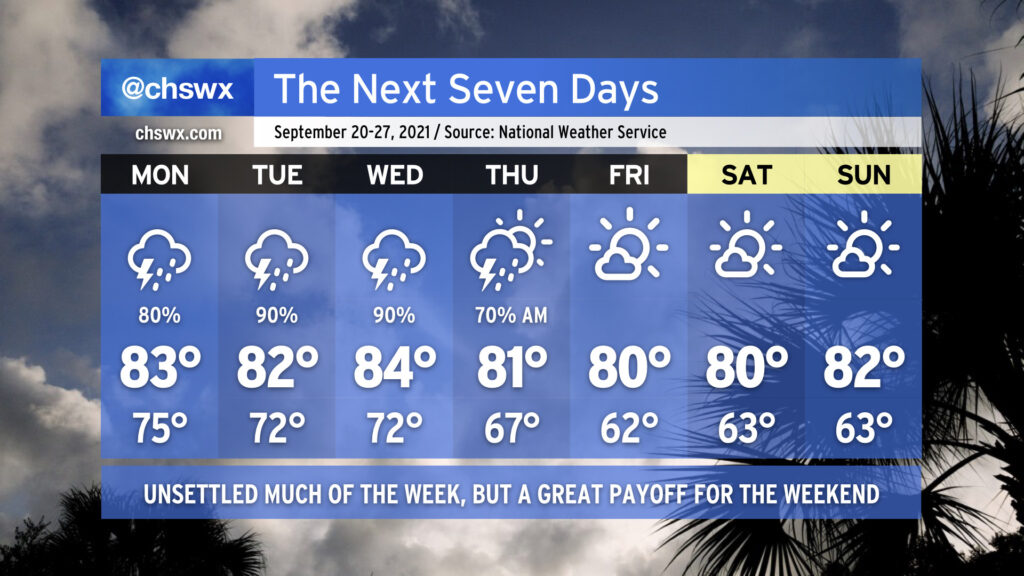
After a coastal trough made this weekend quite a bit wetter than first anticipated, we’ll see rain chances steadily head up throughout the week as an upper low approaches the area and stalls out. Rain chances continue into the weekend as we watch a surface trough approach the area from the Bahamas.
We’ll likely see a wide scattering of showers on Monday, but between high pressure’s last gasp across the area and the better forcing from the upper low staying just to the west, we’ll likely mark Monday as the driest day of the week. Said upper low gets closer and stalls out Tuesday and Wednesday, helping to enhance lift and moisture transport across the area, which in turn improves rain chances. Moisture hangs around into the weekend, keeping rain chances in place as troughing approaches from the Bahamas. NHC is watching this for a slight chance of tropical development, but high wind shear should preclude any development. Shower chances look to persist into the weekend as a coastal trough redevelops and persists.
Temperatures will remain right around normal for early October, but we will remain on the humid side with lows bottoming out around 70° inland and in the mid-70s near the coast.
We will close out September with a weather winning streak intact. Temperatures will gradually moderate into the mid-to-upper 80s as we get into midweek with mostly sunny skies each day. We could see a front swing through later in the week; while it will be moisture-starved, it might be able to squeeze out a storm or two. Then, back into the low 80s for the weekend, with mostly sunny skies prevailing. Not a bad way to close out the month and head into the fourth quarter of 2021 (already!).
Let’s start with the good news: Cooler, drier, fall-like air is coming this weekend. It’s going to be gorgeous. Plan your outdoor activities appropriately.
To get there, though, we need to get through a few soggy days with a risk of flooding, both of the tidal and freshwater (rainfall) variety.
After a really nice weekend across the Lowcountry, we’ll get one more day of low humidity for Monday before high pressure weakens and retreats eastward, bringing back a more summer-like feel to the forecast (sans 90° temperatures, at least). Slight storm chances begin Tuesday afternoon, with more scattered coverage expected each afternoon through the weekend. Temperatures look to remain generally in the mid-to-upper 80s each afternoon, with lows rising into the low to mid-70s starting Tuesday.