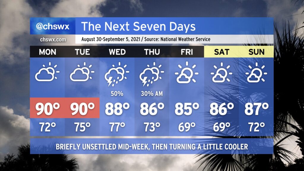
On balance, the week ahead actually looks pretty good. Rain-free but warm conditions (highs ~90°) continue Monday and Tuesday as the ridge of high pressure remains in place across the region. By Wednesday, a cold front and a slug of moisture at least partially sourced from the remnants of Hurricane Ida push southward across the area, scattering showers and thunderstorms across the metro area. The front should clear the area by Thursday, yielding partly cloudy skies and somewhat cooler temperatures with less humidity as we head into the weekend — the first weekend of meteorological fall, which runs from September 1-November 30.
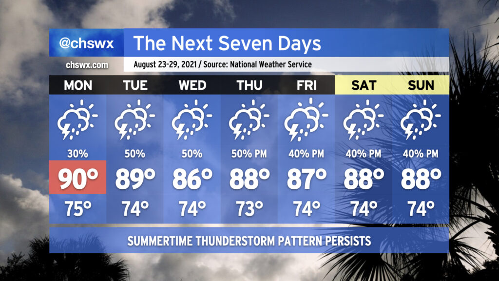
We’ll remain in a somewhat unsettled regime of afternoon showers and thunderstorms each day this week as tropical moisture continues to hang tough in the Lowcountry. Temperatures will generally top out in the upper 80s to around 90° each day. Mix in the humidity and it’ll feel closer to 100°. Not everyone will see rain every day, nor will it rain all the time, but you’ll want to keep a close eye on the weather if you have outdoor plans this week.
Taking a look at the numbers, it’s been a very, very soggy August. 10.83″ of rain at the airport — including August 15’s 4.08″ deluge — is good for fourth wettest to date (as of August 21). Only 1940, 1969, and 1974 have seen wetter starts to the month. We’re a few well-placed downpours away from making a decent run at August 1940’s monthly record of 17.24″ with ten days to go (including whatever falls between the trace of rain at 5PM through the end of the day).
If there’s one bit of good news, though, it’s that the tropics are largely quiet. Henri made landfall in New England earlier today, and with that, there are no named storms in the Atlantic basin. NHC is keeping an eye on an area of disturbed weather near the Cabo Verde Islands, but as of this writing only gives this disturbance a 10% chance of development over the next five days. Otherwise, a round of Saharan dust is going to help keep things at bay a little bit for at least the next few days — suffice to say, we will take whatever break we can get from the tropics in late August. The climatological peak of the season arrives September 10.
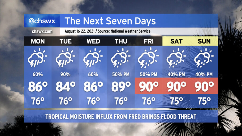
Our soggy summer rolls on with the return of widespread showers and thunderstorms for the first part of the week, particularly as Tropical Storm Fred makes landfall along the Florida Gulf Coast sometime tomorrow and moves northward through western GA into TN. While we won’t see direct impacts from Fred, we are certainly going to be within a plume of deep tropical moisture for the next several days, and this will lead to heavy downpours as a result. Models certainly suggest Tuesday as the wettest day as Fred lumbers up the AL/GA line. A few more inches of rain will certainly be possible, especially in isolated spots where the heaviest downpours occur. We’ll need to keep a close eye out for flooding issues, especially if heavy rain occurs near high tide downtown. The rainfall will keep temperatures in the mid-80s through Wednesday.
As we get into Thursday, Fred’s remnants will be out of the way and we look to begin to return to a somewhat more normal afternoon thunderstorm pattern heading into the weekend. Temperatures will respond by heading back to around 90° each afternoon before thunderstorms fire up.
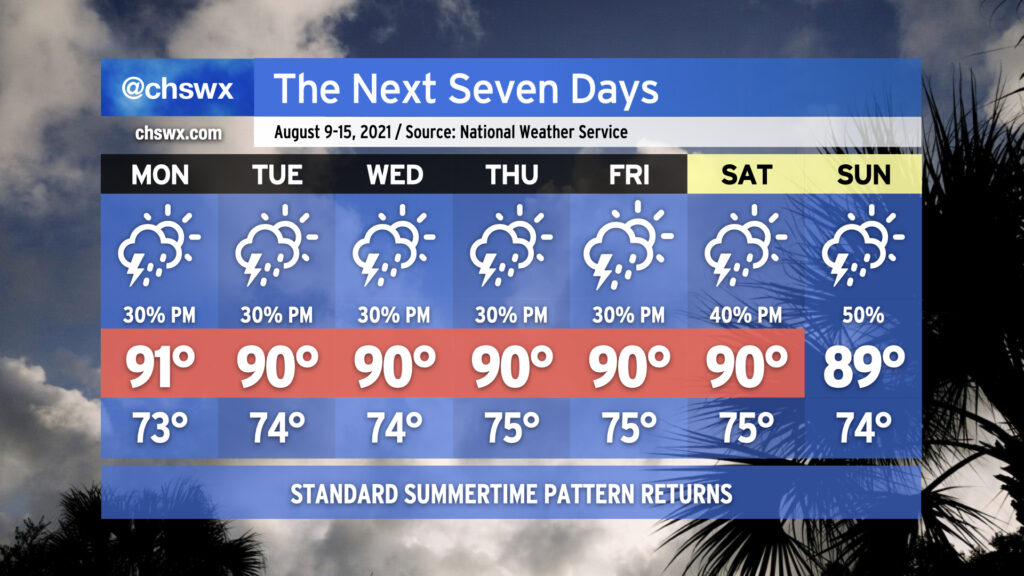
Mercifully, we are headed into a period of relatively normal weather for the next few days. Atlantic high pressure will build in at the surface, and subtropical ridging will move in aloft to click the pattern back into a more standard summertime configuration. Temperatures will top out in the low 90s each afternoon (though the humidity will make it feel closer to 100°), and the inland-advancing seabreeze will be the main focus for any shower or thunderstorm development. Not everyone will see rain every day, and it won’t rain all day at any one location. Just mind the afternoon heat and enjoy the relief if and when you get it.
The good news for next week is that there will be no 110°+ heat indices to speak of. The bad news is that we’ll accomplish this with periods of heavy rain helping to keep temperatures down as a front stalls out across the area. Troughing aloft will help unfettered moisture transport over the next several days, and with the boundary in place focusing development of showers and storms, we look to see quite a bit of rain especially as we get into mid-week.
Monday looks to be the driest day of the work week as showers and storms should hold off until late. (It will also be the warmest day of the week as a result, but highs should only top out around 90°.) Deeper moisture will be shunted southward for a good bit of the day, helping to limit shower and storm coverage. This will change by Monday night, though, as the moisture feed retreats northward. Once this happens, expect the boundary to begin to come alive with periods of heavy rain moving across the area. Generally speaking, this will be the basics of the forecast for the next several days. As of right now, it’s unclear how long this setup will remain in place, especially when looking toward the weekend.
It’s important to note that this doesn’t mean it’s going to rain all the time. It is difficult to predict exactly when and where the heaviest rain — and the dry slots — will set up more than a day in advance in regimes like this. The general advice is this: Prepare to have plenty of indoor plans this week, monitor forecast updates for dry periods, and stay alert for the potential for flooding, especially in advance of and around times of high tide. That, and don’t totally toss your weekend plans just yet, as there’s plenty of uncertainty in the long range.
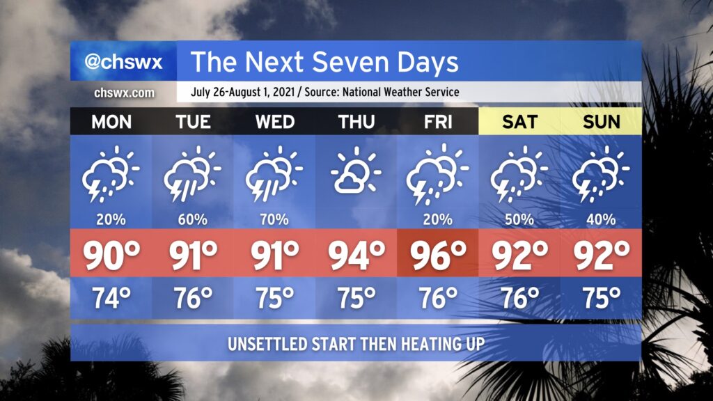
After a very rare weekend of relatively low humidity (for late July, anyway) we’ll see dewpoints return to the low to mid-70s as tropical moisture builds back into the area. Monday will feature isolated showers and thunderstorms primarily driven by the seabreeze, but as we get into Tuesday and Wednesday, a low pressure system — labeled by the National Hurricane Center as Invest 90L with a 50% chance of tropical development — will be approaching the coastline as we get into mid-week. Regardless of what it ends up doing from a tropical standpoint, it will enhance our shower and thunderstorm chances Tuesday and Wednesday, particularly in the afternoons. Temperatures will top out in the low 90s each day.
As we get closer to the end of the week, the strong high pressure over the central US noses its way into the eastern US. This, in turn, will drive down rain chances and drive up temperatures. Temperatures should top out in the mid-90s Thursday and Friday.
Owing to just how “mild” this summer has actually been, the hottest it’s been this year is 94°, which we’ve reached three times (twice in May and last on June 15). If Friday’s forecast of 96° verifies, that will be the warmest we’ve been all year.
By the weekend, we could see an uptick again in showers and thunderstorms as the ridge backs off a little bit and we get underneath some northwest flow aloft. NWS noted in its afternoon discussion that this could open up the pathway for summer thunderstorm complexes — the technical term for which is “mesoscale convective system” — to roar through the area starting this weekend. Something to watch, but nothing we need to be overly concerned about right now.
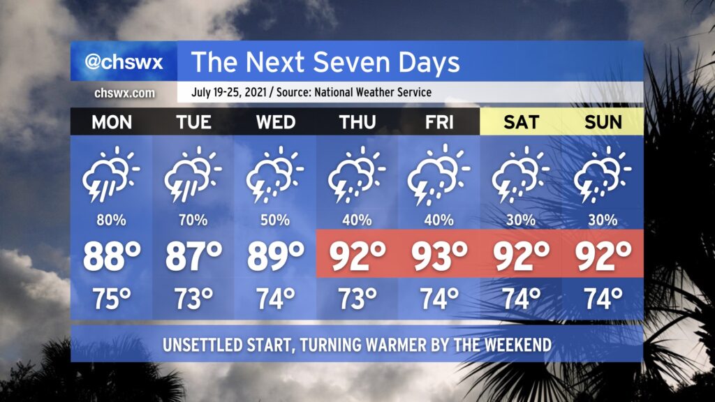
We’ll be getting this work week off to a wet start. Showers and thunderstorms will be commonplace as upper level energy combines with a stalling surface front and copious amounts of atmospheric moisture especially Monday afternoon into Tuesday. Heavy rain is certainly a concern, and we will want to monitor the risk for sporadic freshwater flooding episodes closely. Clouds and rain look to keep highs down into the mid-to-upper 80s, a few degrees below normal for this point in July.
As we get into Wednesday, we begin to see this soggier pattern break down and a more standard summertime regime returning to the area. We are back in the 90s by Thursday with more scattered coverage of showers and thunderstorms primarily in the afternoons heading into the weekend.
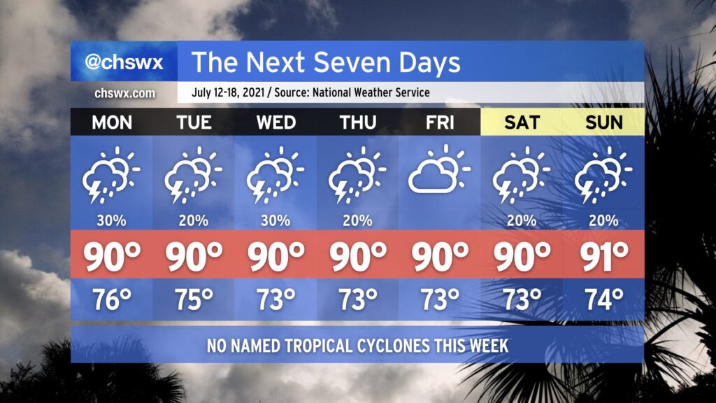
For the first time in three weeks, we do not have any concerns about a tropical cyclone influencing our forecast. Hooray! We’ll have a much more typical July week of weather ahead featuring temperatures around 90° each afternoon and a chance for isolated to scattered storms pretty much each day, mostly in the afternoons (though Monday could get started and end a little earlier). The only severe weather that might occur this week would be where thunderstorm outflow boundaries interact and enhance lift, perhaps bringing a brief damaging wind threat via downburst winds. Atlantic high pressure building across the area will otherwise put a lid on more widespread shower and thunderstorm activity.
Southerly winds around the high will give us a little bit of an onshore component to the wind, which will help regulate temperatures to near normal levels. We won’t be able to escape the 70s dewpoints, though, so be ready for heat indices in the upper 90s to near 100°, especially around the time the seabreeze circulation passes your location.
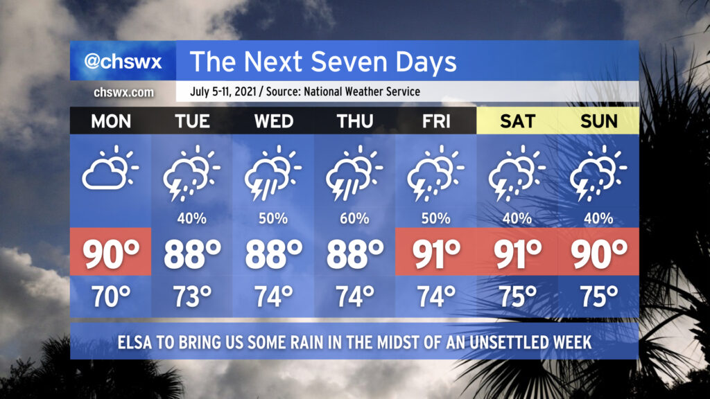
We get one more rain-free day on Monday to close out the observance of Independence Day before moisture and unsettled weather return to the picture. Much of this will be influenced by the eventual track and strength of Elsa, which as of the 5PM advisory, is currently forecast to be a depression as it traverses the area sometime Wednesday into Thursday (more on that in a sec). Overall, get ready for periods of showers and thunderstorms with heavy rain and temperatures right at or a little below normal each afternoon, particularly in the middle of the week as Elsa gets involved with the forecast.
Heavy rain moves through the Charleston Metro Area.
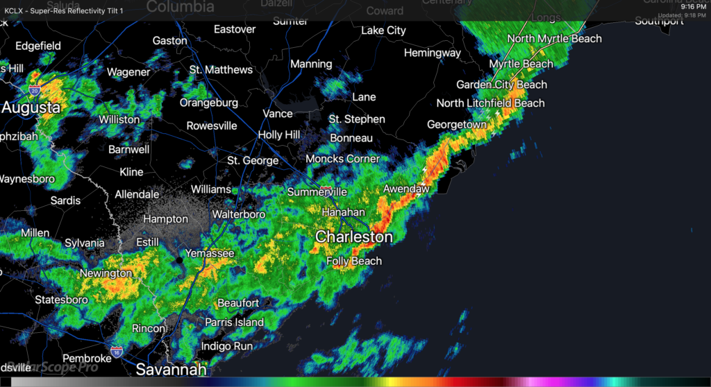
As of about 9PM, Claudette’s center was moving eastward across northern parts of South Carolina. The exact center fix is a little murky, but radar suggests that as of this writing it is roughly riding the SC/NC border around Chesterfield County, SC. The leading edge of Claudette’s primary rain band has cleared downtown Charleston and is headed offshore, with light to moderate rain behind it. This rain band appears to have cleared downtown with relatively little fanfare, but winds have been gusting quite a bit, with a recent gust to 62 MPH recorded at the Isle of Palms WeatherFlow station.
Light to moderate rains look to continue for the next few hours as the primary rain band swings through the area. It appears that there could be additional showers and thunderstorms behind it; these are moving southeastward out of Augusta and could swing around into the Tri-County before it’s all said and done. A Flash Flood Watch continues across the Charleston Metro Area effective until 8am Monday, though this may yet be canceled early once this band lifts out.
The risk for severe weather (particularly the tornado threat) has ended across our area at this point. With the center directly to the north, surface winds coming out of the west lowering shear, and instability having been sapped by the rain band, the environment is not really conducive to tornado formation anymore. We caught a break with this today, especially considering the ample sunshine we saw for a good bit of the day to aid destabilization. Still, straight-line gusts of 40-50 MPH across saturated grounds could still be sufficient for downed trees and power lines, so keep flashlights nearby in case of power outages.