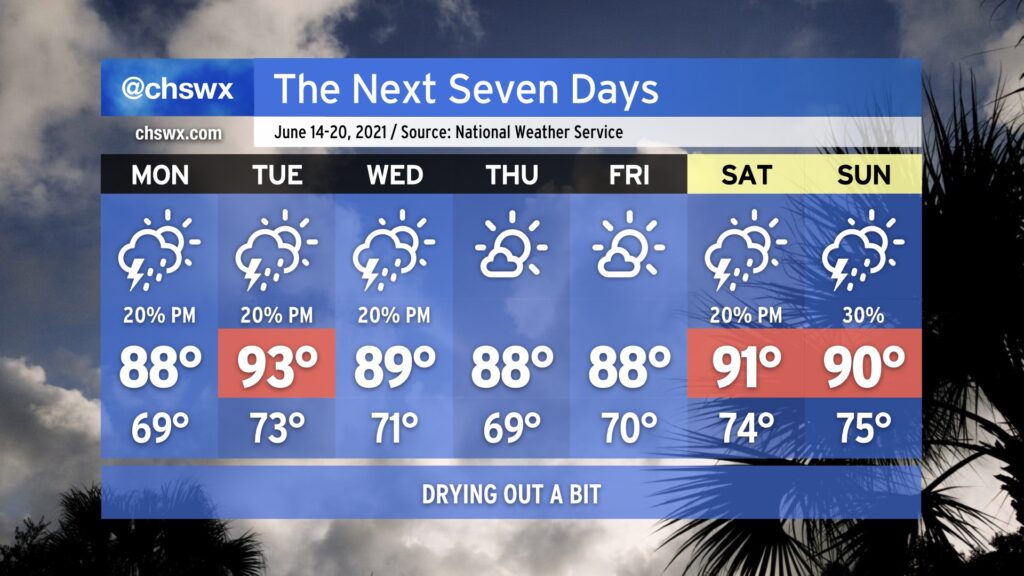
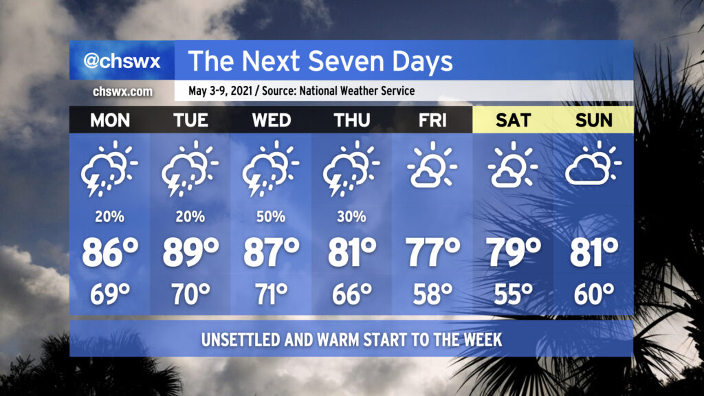
After a very soggy weekend, we will get the opportunity to dry out a bit as the deep moisture plume which has been in place for the last few days finally gets shunted away from the area. This week is going to be pretty standard June fare: highs in the upper 80s to low 90s with a chance of isolated afternoon thunderstorms will be common. Thursday and Friday will be a touch cooler and drier in the wake of another front moving south of the area, and this could put the kibosh on even slight chances of afternoon showers and storms (though you can never totally rule it out at this point in the year). Expect slight shower and storm chances to return for the weekend as a little more moisture gets fed our direction from the Gulf.
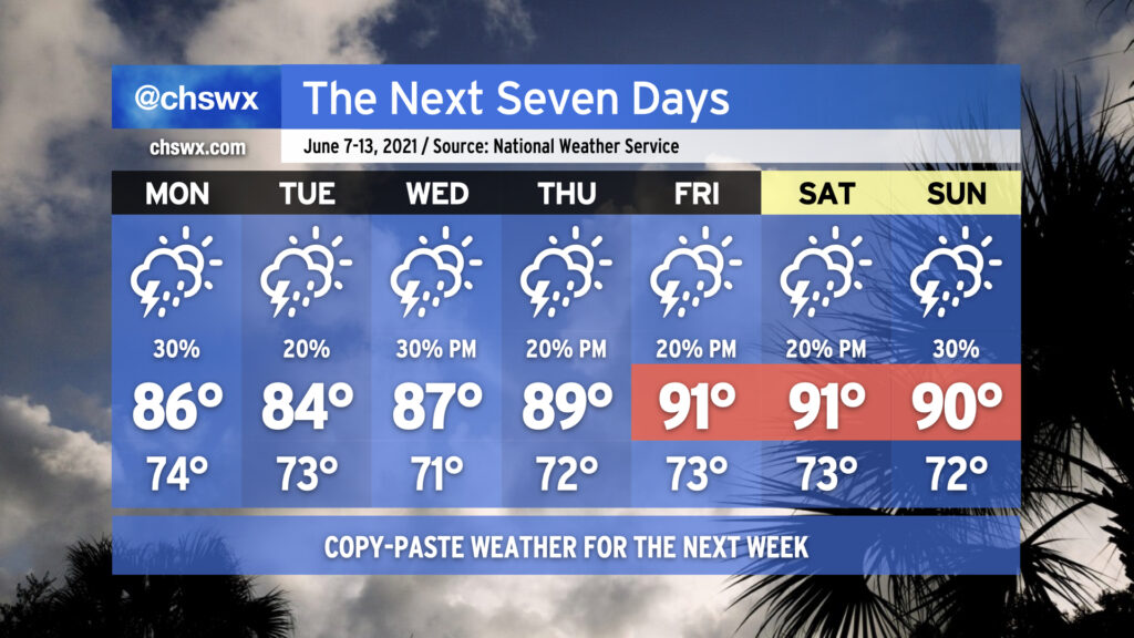
We’re getting into “copy-paste season,” when the summertime weather pattern is such that you’ll be pretty much on point with upper 80s to low 90s and a 20% chance of storms each afternoon. Of course, much more science goes into the forecast than that, but it goes to show just how static the pattern looks to be for the next few days. As is customary in summer, showers and thunderstorms will be isolated to scattered in nature. It will not rain everywhere, and it will not rain all day. It will be impossible to say with much certainty where storms will form, and if we are lucky to get clues as to where thunderstorms may initiate, we won’t have a lot of lead time.
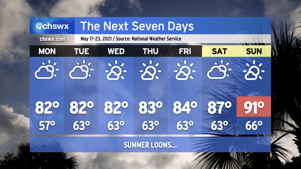
Temperatures will start around normal before creeping up into the 90s by the weekend. Combined with humidity, that may yield our first 100°+ heat indices of the season, so that’s something you’ll want to plan for if you have outdoor activities scheduled.
Welcome to summer, folks. (Meteorological summer started on June 1; the summer solstice will take place on June 20.)
The upcoming work week will feature temperatures right in line with what we would expect from the third week in May with low-to-mid-80s quite common away from the coast. Humidity will be creeping up a little bit beyond Monday, which will be felt primarily through slightly warmer low temperatures in the low 60s. Keep the sprinklers on standby throughout the week as you’re going to need them with dry weather expected for the next seven days thanks to high pressure at the surface and aloft keeping a lid on afternoon convection. This will expand on this spring’s rainfall deficit, which stands at 2.19″ at publish time. (We are hanging on to a 0.66″ surplus for the year, but this should be erased by the end of this week.)
As we reach the weekend, we’ll start to see the heat kick up a notch as the ridge aloft strengthens. The first 90° temperature at the airport in 2021 should be achieved by Sunday; if this ends up being the case, it’d be the latest first 90° day since 2005. Dewpoints in the low 60s will keep heat indices in check for now, but it’s only a matter of time before the humidity begins to kick in.
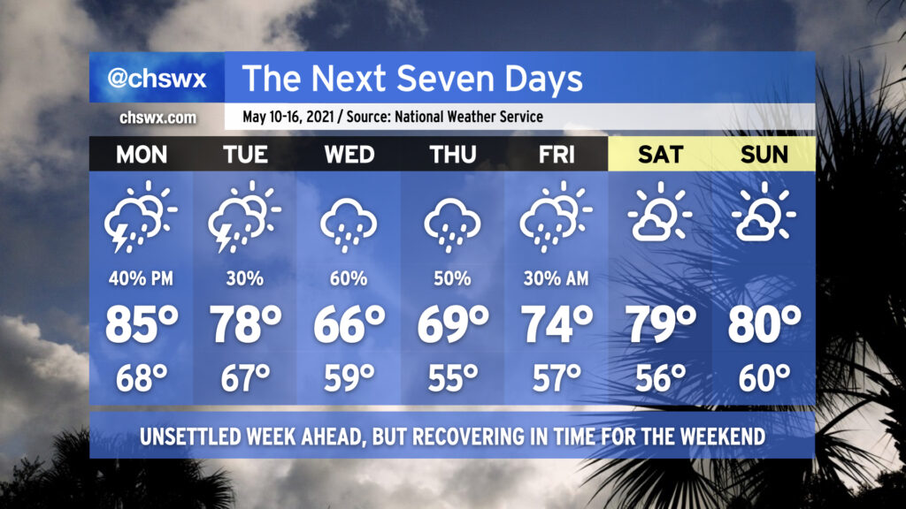
After an excellent weekend of weather, we’re back into a bit of an unsettled pattern for the work week. Monday should be mostly dry to start, but showers and thunderstorms will be possible in the afternoon as mid-level energy works its way through the area. Highs will top out in the mid-80s with humidity making it feel a little warmer.
We’ll begin to see a frontal boundary sink into the area on Tuesday, bringing another chance for scattered showers and thunderstorms throughout the day. As the front sinks southward, a wedge of high pressure will begin to build in from the north and northeast, spelling a chilly (by mid-May standards) couple days for Wednesday and Thursday with highs only topping out in the mid-to-upper 60s. Rain looks likely as moisture overruns the wedge, and we sure could still use it as abnormally dry conditions persist across the Lowcountry.
By Friday, we begin to see drier high pressure reassert itself. Rain chances will remain with us especially in the morning before clearing the way for another gorgeous weekend of weather. (I like it when the pattern works out like this!)
Get ready for a very summer-like start to your week. High pressure slipping into the Atlantic with a little ridging aloft will keep us warm — dare I say it, hot — and humid for the first part of the week. Showers and thunderstorms will be possible each day through Thursday before a cold front swings through with drier air and more pleasant temperatures for the weekend.
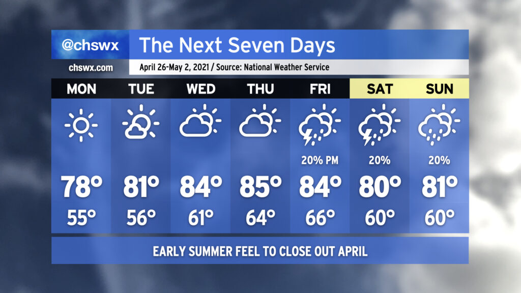
April will come to a close in a very familiar way: Warm and rain-free. Monday looks excellent, weather-wise, with clear skies and highs topping out in the upper 70s in the afternoon with an onshore breeze. High pressure will slowly slide offshore over the next few days, and the resulting return flow along with pronounced ridging aloft will allow temperatures — and dew points — to creep up as the week goes on. By Thursday, we’re doing mid-80s in the afternoon ahead of a cold front. The forecast picture becomes somewhat murky as we head into the weekend, with some solutions keeping us rain-free and others bringing showers and thunderstorms into the area. NWS split the difference for now and is indicating a 20% chance of showers and thunderstorms Friday-Sunday, with the expectation that this is going to change. So, stay tuned.
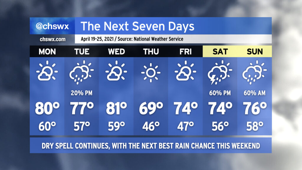
Our long-standing dry spell will continue for much of this week, save for a small chance of showers on Tuesday as a little upper-level energy ripples through.
Mostly sunny skies will prevail on Monday as temperatures reach right around 80° — still a few degrees above normal at this point in the year. We’ll run a touch cooler on Tuesday with a few more clouds in place and perhaps even a shower or two, but those won’t be enough to break us from our abnormally dry April. Mostly sunny skies return on Wednesday ahead of a dry cold front which will swing through overnight. By Thursday, cool high pressure will build in with temperatures near 8-10° below normal across the area under clear skies. High pressure gets off the coast on Friday and temperatures recover to the mid-70s with gradually increasing cloud cover in the evening ahead of a storm system.
If we are going to thwart the driest start to April since 1976, it’s likely going to happen Saturday afternoon into Sunday morning as low pressure moves through the area. At this range, of course, there are certainly model differences, and we will need to see how the details ultimately unfold, but this is the best shot at rain we’ve had probably all month! We’ll watch it closely. For now, though, keep watering your plants and washing your cars as we get through another dry work week.
We’ll start out another work week with pretty nice weather in the wake of a cool front (can’t really call it cold with temperatures rebounding into the 80s, but the airmass will at least be drier!) before seeing another front by mid-week potentially bringing some unsettled weather.
Temperatures will start out this week in the 80s on the afternoons and mid-50s to around 60° in the mornings as high pressure moves through the area both at the surface and aloft. After a couple days of tranquil weather, cloud cover will thicken up on Wednesday as a cold front gets closer to the area. A few showers aren’t totally out of the question in the afternoon.
Forecast confidence gets a little iffy as we get into Thursday, with some timing differences in the models — the ECMWF is faster in getting the cold front through, while the GFS is about 12-18 hours slower — and thus invites some questions in when rain will move through the area. Indeed, NWS notes that forecast confidence is pretty low headed into the weekend as model differences persist. So, stay tuned as the details get sorted out, and don’t cancel any plans just yet.
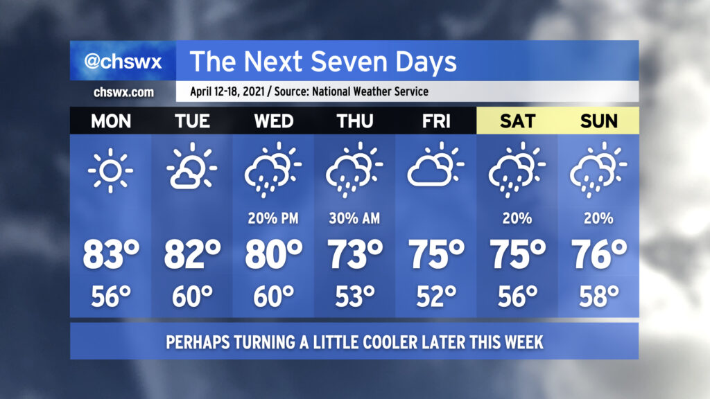
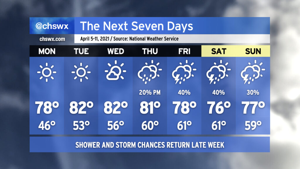
After quite a cold snap closed out last week, temperatures will be back at or a little above normal as we get into the first full week of April. There will be plenty of sunshine in the offing particularly Monday through Wednesday as high pressure maintains firm control over our weather. Lows will start out in the upper 40s on Monday but will warm into the mid-50s by Wednesday morning. Highs will generally run in the upper 70s to low 80s.
Changes begin to show up in the form of at least a few more clouds for Thursday as a storm system starts shoving the surface high offshore, allowing for some more moisture return. There’s an outside shot at a few showers Thursday evening, but the better rain chances will be ahead of the storm system’s cold front on Friday. We could see a few thunderstorms in the mix as well. The front will get through Saturday, but lingering moisture keeps rain chances in the forecast for most of the weekend. It doesn’t look like a washout, though, and as always, we’ll have time to fine-tune the details throughout the week. For now, enjoy the warm sun!
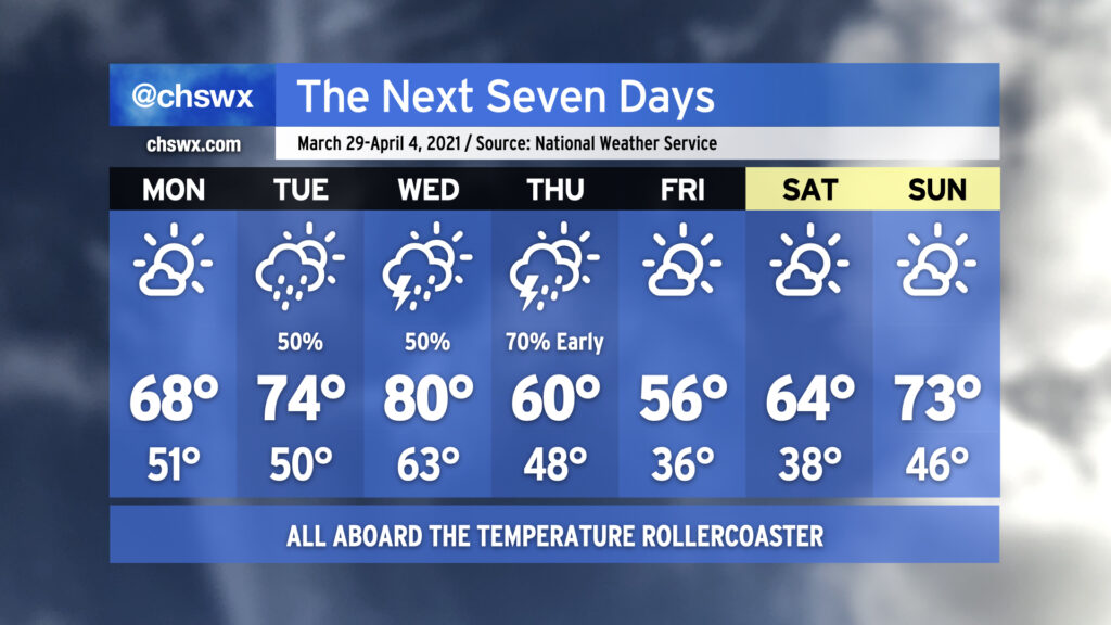
Spring, being a transitional season, will often give you its share of weather whiplash. This is going to be one of those weeks where your jacket and shorts should stay within equal reach.
We start the week with high pressure asserting control over our weather, albeit briefly. It’ll be much cooler — we’ll start Monday in the low 50s. Late-March sunshine will be enough to push temperatures into the upper 60s, but that is still a little cooler than normal for this time of year. Temperatures moderate a bit on Tuesday as high pressure slips offshore, but we’ll also see shower chances return to the picture as well.
Our best thunderstorm chances this week come Wednesday into early Thursday as a warm front lifts north across the area followed by a strong cold front. We could warm to around 80° on Wednesday post-warm frontal passage before the mercury comes crashing back down to earth for Thursday, when temperatures will struggle to 60°. Frost and freeze issues could very well come into play Friday morning as temperatures dip to the mid-30s in the immediate Charleston Metro Area with colder temperatures, perhaps flirting with freezing, further inland. The high on Friday should only top out in the mid-50s despite ample sunshine, owing to the abnormally chilly airmass working its way into the area to help get April started out on a chilly note. The early April sun angle will help modify this airmass, though, with temperatures warming back to around normal by Sunday. It’ll be a nice weekend to get outside with plenty of sunshine and comfortable humidity levels expected.