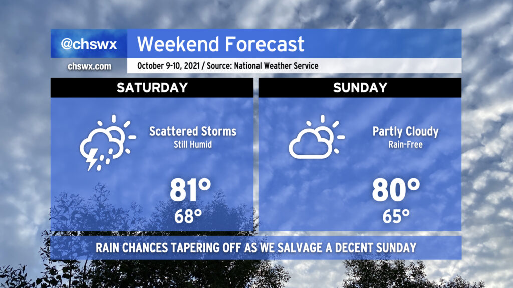
There is a light at the end of this very muggy and rainy tunnel as we get into the weekend. We’ll still be dodging scattered showers and a few thunderstorms on Saturday as low pressure meanders nearby and some upper-level energy moves through. By Sunday, though, a little drier air works its way in and the low shifts away for what should turn out to be a fairly nice day. We’ll keep a mix of sun and clouds around, but rain looks to stay away as temperatures peak around 80° in the afternoon — not too bad for this time of year.
We will need to continue to watch times of high tide Saturday and Sunday morning for minor to moderate coastal flooding with the new moon and some north to northeast winds. Tide levels could approach 7.5′ both days, causing some road closures in Downtown Charleston. High tide on Saturday morning will arrive at 10:49 AM, and on Sunday morning around 11:45 AM. Expect flooding 1-2 hours either side of high tide.
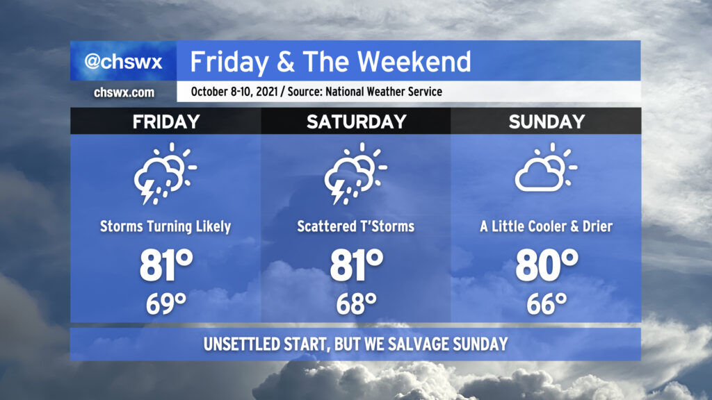
Our unsettled pattern continues into the weekend as low pressure meanders offshore and we stay within some troughing aloft. Another round of widespread rain will characterize Friday as storms develop in GA and move northeastward through the afternoon. From there, scattered showers and thunderstorms will persist into Saturday before the aforementioned low pressure moves a little further away to our north and east, allowing for some drier air to filter in from the north to keep Sunday rain-free and a little more comfortable to boot.
Astronomical influences and onshore winds will continue to cause coastal flooding issues around times of high tide through the weekend. Moderate coastal flooding is in the forecast for high tide around 9:58 AM Friday. With the forecast between 7.5-7.7′, we can expect some road closures to occur in and around Downtown Charleston. Another round of moderate coastal flooding, which could peak even higher, is expected Saturday morning around the 10:49 AM high tide, causing another round of road closures. As always, we’ll need to see what the rain is doing around this time as well as any water on top would be most unwelcome. Moderate coastal flooding will again be an issue around midday Sunday, but the risk for rain will be much lower than previous days, so the specter of more widespread problems is diminished.
Hang in there — next week is looking drier, at least. True fall weather, though, still appears to be well down the road as elevated dewpoints and ridging aloft will keep temperatures above normal through the end of next week.
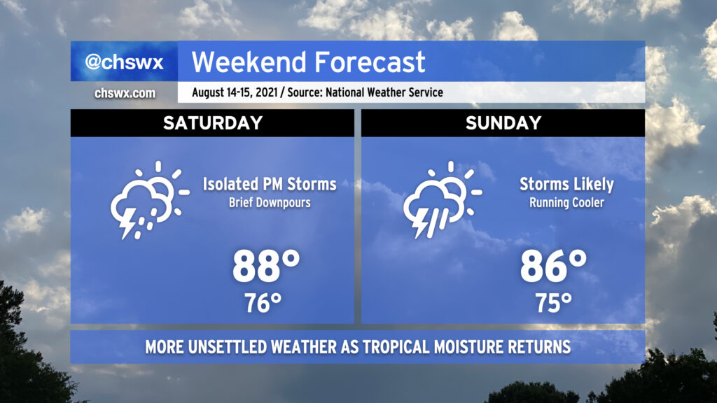
Pro tip: Mow the lawn Saturday morning, because we could start to see some showers and storms enter the picture in the afternoon as high pressure begins to weaken across the area. It’ll still be warm, but temperatures will be limited to the upper 80s by more pervasive cloud cover.
Why mow Saturday? Because Sunday is going to be a lot tougher to get that mowing in, and it doesn’t get better getting into next week. Showers and thunderstorms look to become a little more widespread Sunday, with on-and-off storms possible for a good bit of the day. As usual in summer, it won’t rain all the time, but when it does, a brief downpour or two could drop a decent amount of rain.
As we get into next week, a continued feed of tropical moisture and a stalled front will interact will keep scattered to widespread showers and thunderstorms in the forecast, particularly in the afternoons.
Scattered showers and thunderstorms will continue to feature prominently in the forecast as we get into Saturday, with perhaps another round of morning storms to greet us as a mid-level trough and some embedded energy draws closer to the area. With the warm front north of us, peeks of sun should allow temperatures to continue to moderate into the mid-to-upper 80s in the afternoon.
By Sunday, the troublesome trough lifts out of the area and we get back into more of a traditional summertime regime. Scattered storms will continue, though they should be a little less numerous Sunday. Highs return to the 90s across the area and look to stay that way as we get into the new work week. But it’s the weekend, and there’s no reason to think about the new work week right now. 🙂
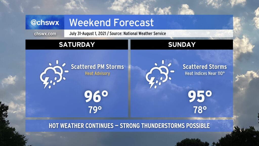
We will continue our string of hot days this weekend as we remain under mostly westerly flow at the surface and aloft. A cold front will be closer to the area, though, and this along with some upper-level energy will instigate a few more showers and thunderstorms starting Saturday afternoon. A few of these storms could turn severe with damaging wind gusts the primary concern; locally heavy rain and lightning will also certainly factor in. Shower and thunderstorm chances continue into Sunday, though it won’t rain all day.
Heat and humidity will continue to combine for heat indices around 110° on Saturday and perhaps approaching that number again on Sunday. A heat advisory is in effect for Saturday afternoon as a result; you’ll once again want to take heat safety precautions if you must be outside.
The heat will back off Monday, but at the cost of the resurgent potential for isolated flooding rainfall as deeper moisture and upper-level features become favorable once again for very heavy rainfall.
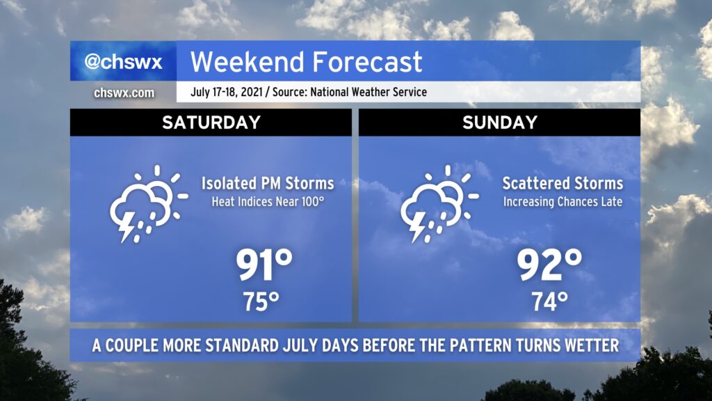
We’ve got more of the same July weather in store for the weekend. Heat and humidity will continue across the Lowcountry as highs top out in the low 90s each afternoon. Heat indices will approach 100° with the humidity in place, so be sure to watch your exertion during the peak of the afternoon heat.
Much like the last few days, we’ll see isolated showers and thunderstorms initiate on the seabreeze and move inland on Saturday. The pattern begins to change up on Sunday as a cold front begins to approach the area. Rain chances increase later in the day, and if the convection-allowing models are correct, it could be a somewhat stormy Sunday night. We’ll want to watch that trend, but overall, I hope you can enjoy a good weekend for summer activities across the area.
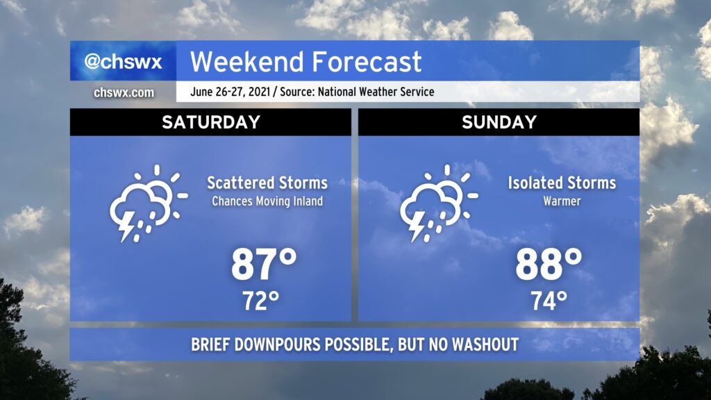
This weekend will feature scattered storms both days, with a little better coverage on Saturday as a trough moves inland. The good news is that it won’t rain all day, and there will be plenty of sunshine mixed in around the storms. Coverage becomes more isolated on Sunday, generally along and ahead of the seabreeze. Severe weather doesn’t look to be a major issue, but remember that all thunderstorms are dangerous thanks to the lightning they produce.
Temperatures will run a little warmer this weekend, but onshore flow will continue to keep them tamped down a few degrees below normal (about 90° this time of year). Mix in humidity and it’ll feel a little more like the low 90s in the afternoon. That’s pretty warm, but it could be so much worse in late June.
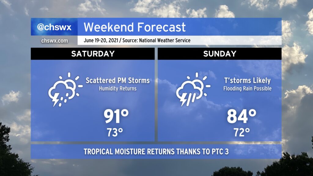
It’s been a great couple days of weather in the Lowcountry, but the remnants of Potential Tropical Cyclone Three look to bring unsettled weather back beginning Saturday afternoon.
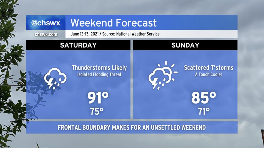
We will get off to an unsettled start to the weekend as a frontal boundary sags south into the area during the day on Saturday. Ahead of the front, expect highs to top out in the low 90s before numerous showers and thunderstorms develop across the area. Chances are pretty good that you’ll see at least a little rain at some point tomorrow. With plenty of available moisture to wring out, though, it is conceivable that flooding may be a concern tomorrow within the strongest storms. While severe weather looks unlikely, all storms are dangerous due to the lightning they produce. When thunder roars, go indoors!
It’s expected that the front will pass through and stall out to our south by Sunday. Temperatures will run a little “cooler” with highs topping out in the mid-80s, but scattered showers and thunderstorms should still develop in the afternoon. How Sunday ultimately evolves will depend on what goes on during the day Saturday, so keep an eye out for forecast adjustments.