Jared Smith founded @chswx on Twitter in 2008 as an experiment in disseminating weather data through social media. In the ensuing decade-and-a-half, @chswx has provided live coverage of tropical cyclones, tornadoes, severe weather, and even a couple bouts of winter weather to the good people of Charleston, SC.
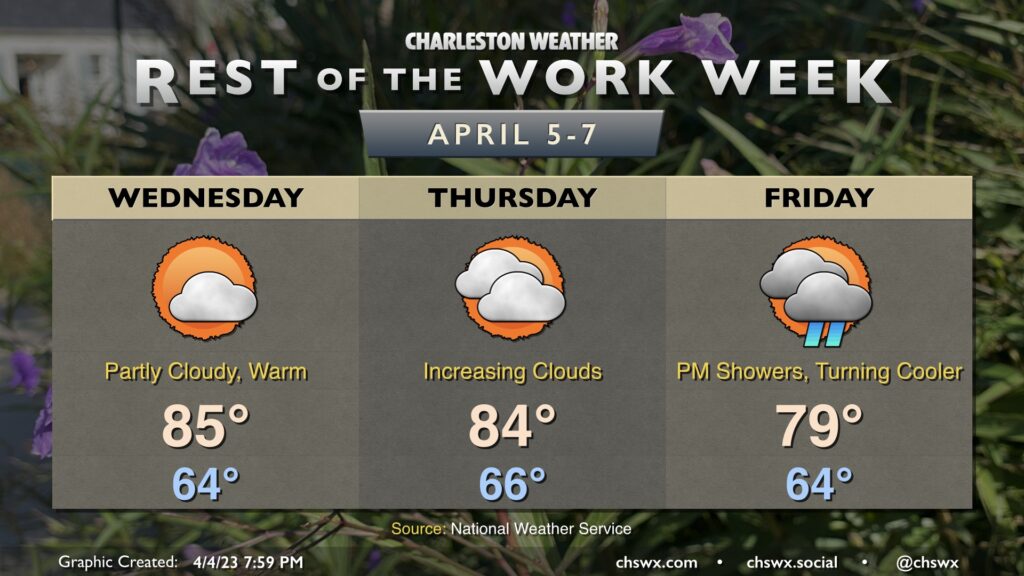
Above-normal temperatures will continue through Friday before a cold front stalls out to our south. Wednesday will feature another partly cloudy day with highs running in the mid-80s once again as ridging takes hold aloft. The ridge will begin to slip a little and clouds will increase ahead of the next storm system on Thursday. Despite the increasing cloud cover, we’ll have one more day of highs in the mid-80s.
We start quite warm once again (mid-60s) on Friday before scattered showers and maybe a thunderstorm or two advance into the area ahead of a cold front later in the day. The frontal passage is looking a little later now, so we should still see highs approach 80°. The front will then stall to our south and high pressure will wedge into the area, leading to a much cooler and wetter weekend in which highs will likely not get out of the 60s.
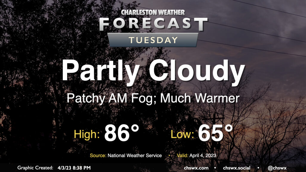
Lingering showers will clear the area overnight, setting us up for a much warmer Tuesday as winds go more westerly and clouds scour out. Expect highs to peak in the mid-80s away from the coast in the afternoon after starting the day in the mid-60s. These temperatures easily run 10°+ above normal for this point in the year, where the normal high is 74° and the normal low is 52°. (The record high for April 4 of 91°, set in 1963, mercifully remains safe.)
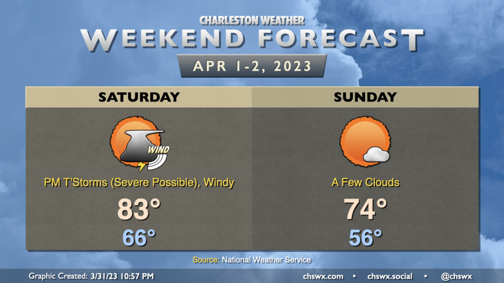
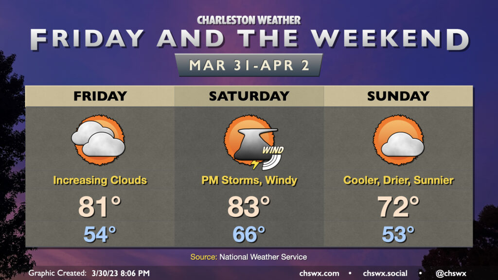
A cold front will be working its way eastward into the metro area throughout the day Saturday, but its associated rainfall will arrive in the late afternoon and early evening, sparing the Bridge Run. It’ll be windy; gusts 30-35 MPH will be possible especially heading into the early afternoon, and this may contribute a bit of a headwind at times during the race. After starting in the mid-60s, temperatures should head into the low 80s in the afternoon ahead of the cold front.
A line of showers and thunderstorms will precede the cold front. It should be losing some steam with the bulk of the energy staying well north, but there is ample wind shear and should be enough instability for a few of these storms to be on the stronger side with wind damage the main concern. Some hail and even a tornado can’t be totally discounted, either, so you’ll want to make sure you have ways to get warnings tomorrow. These look to get into western parts of the Tri-County in the 3-5 PM timeframe, pressing off the coast by 6-7 PM with showers to fall for a little while afterward.
Once the front is through, cooler and drier air works its way into the area. Overall, Sunday should run about 10° cooler than Saturday with a lot more sunshine. It’ll be the pick day of the weekend for outdoor activities with comfortable warmth and low humidity.
Our warming trend continues Friday ahead of a cold front that’ll arrive here Saturday evening with a few showers and storms out ahead of it. (We still look okay for the Bridge Run, though.)
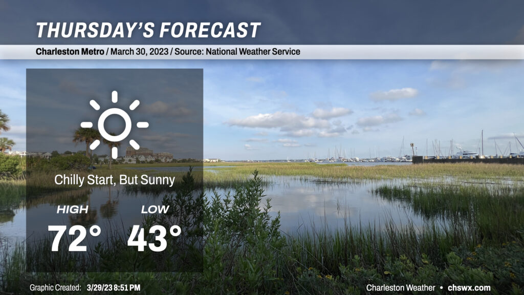
Calm winds and clear skies will allow temperatures to fall quite nicely tonight, with lows bottoming out in the low 40s across much of the metro area to start Thursday. (Thankfully, not low enough to deal with frost or freeze concerns.) Full sunshine will allow temperatures to warm nicely into the low 70s, making for what should be a rather pleasant day across the Lowcountry.
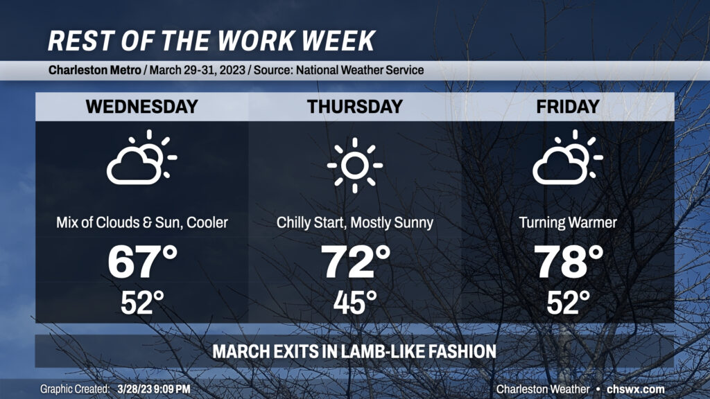
The final few days of March 2023 will be generally quiet, weather-wise (at least here in the Lowcountry), as a cold front moves across the area overnight and ushers in a cooler, drier airmass. Wednesday will be much cooler than recent days with highs peaking in the mid-60s. We’ll see a mix of sun and clouds throughout the day as a little lingering low-level moisture hangs around, but that’s about it.
The aforementioned moisture strips out later Wednesday, yielding a brilliantly sunny sky on Thursday. We’ll get off to a chilly start thanks to calm winds and clear skies from the night before with lows in the mid-40s (far from frost or freeze concerns, thankfully). Highs will reach the low 70s. All in all, not a bad day to get outside and take a walk.
Winds go around to the south beginning Thursday and this will yield a warmer Friday. Expect temperatures to peek in the upper 70s under partly cloudy skies. The 18z runs of the models indicate the potential for some showers coming ashore Friday afternoon; we’ll keep an eye on this, but for now, the going forecast is for mostly dry weather as some of you head out to pick up your Bridge Run packets.
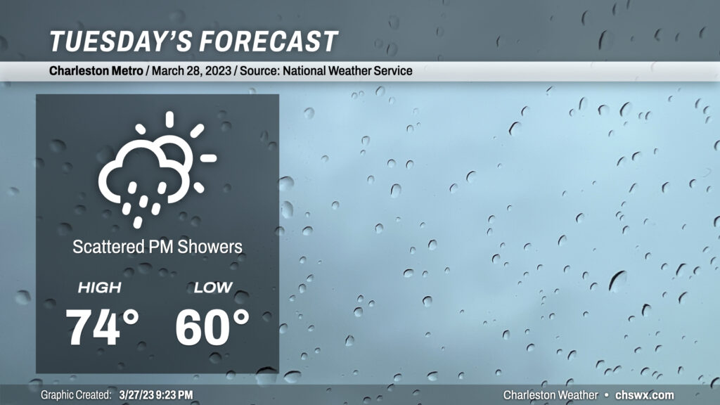
A cold front will swing through tonight and will stall out across southeast Georgia. This will take a little bit of the mugginess out of the air for Tuesday, though scattered showers will be possible in the afternoon and evening hours as a disturbance moves on through. However, with the lower dewpoints — think upper 50s rather than mid-60s — the risk for thunderstorms is just about nil, and the risk for severe weather is nonexistent. Just watch for some patches of fog in the morning. Highs climb into the mid-70s at best given the slightly drier airmass, continued cloud cover, and the expected shower activity.
Overnight Tuesday, a shot of much drier air works its way into the area, leading to a much cooler — but sunnier — Wednesday, followed by a warming trend back into the 80s to close out the work week.
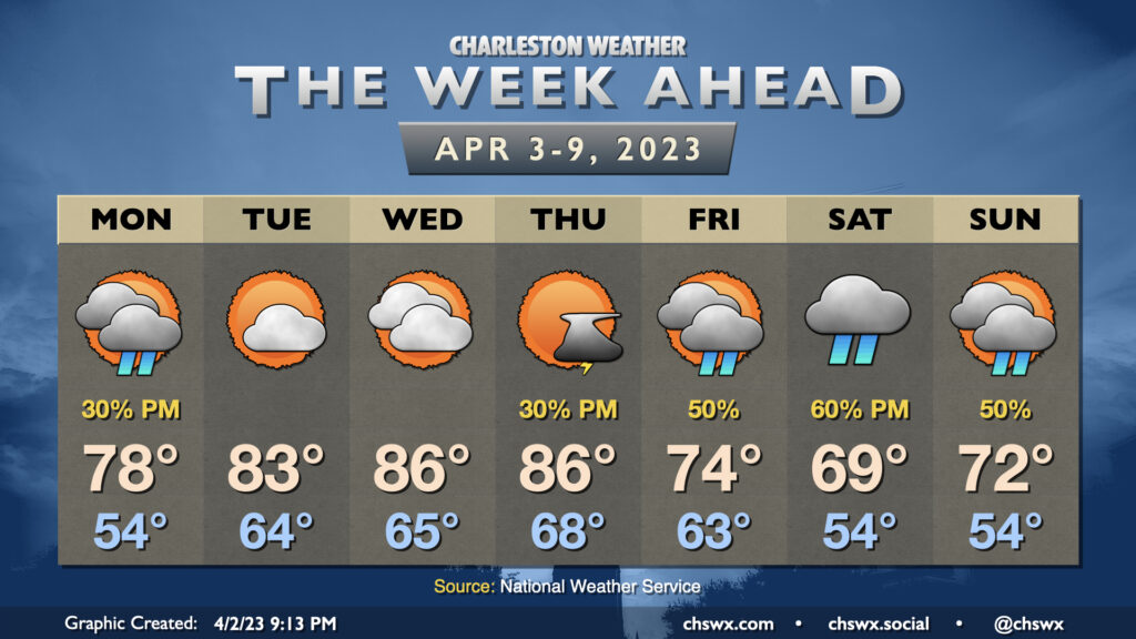
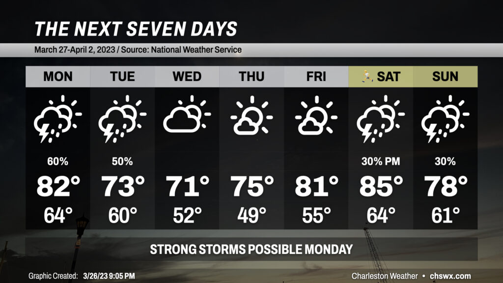
The week ahead will get off to a rather stormy start as a stalled front continues to keep the risk for showers and thunderstorms in the forecast through Tuesday, a few of which could be on the strong to severe side (especially on Monday). We cool off briefly mid-week before 80s return ahead of another front for the weekend, making for a possibly muggy Bridge Run.
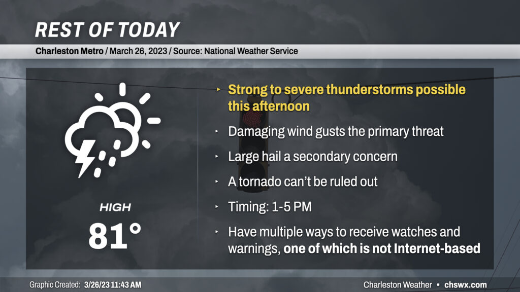
A few strong to severe thunderstorms are possible this afternoon as waves of energy aloft interact with a nearby stationary front. As of this writing, a band of showers and thunderstorms was located just north of the Tri-County, stretching across central GA, the CSRA, and the Midlands. Outflow from these storms may, in time, trigger additional thunderstorm formation closer to the metro area. Shear and instability profiles are supportive of a few organized severe thunderstorms. Straight-line winds are the primary concern, though steep mid-level lapse rates seen on soundings are also supportive of large hail within the strongest storms. The overall tornado risk is low, but where boundaries interact, a quick spin-up can’t be ruled out.
Stay weather-aware this afternoon. Make sure you have more than one way to receive a weather warning, including one that doesn’t use an Internet connection. Social media should be a supplementary way of receiving information, but should not be used as a sole source as those sites can go down or show information that is far out-of-date.