Jared Smith founded @chswx on Twitter in 2008 as an experiment in disseminating weather data through social media. In the ensuing decade-and-a-half, @chswx has provided live coverage of tropical cyclones, tornadoes, severe weather, and even a couple bouts of winter weather to the good people of Charleston, SC.
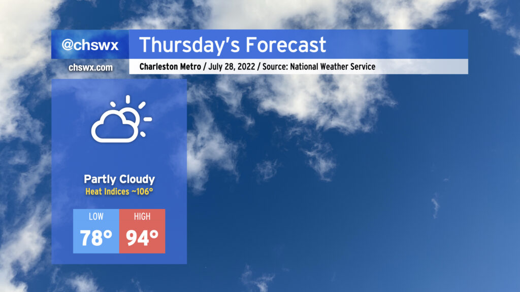
Another hot day is in store Thursday. After starting in the upper 70s away from the coast and Downtown (lower 80s there, gross), temperatures will warm to the mid-90s in the afternoon under partly cloudy skies. Mix in humidity and that’ll yield heat indices around 106°, plenty warm enough for heat exhaustion concerns during the peak of the afternoon. Much like today, expect rain-free conditions to persist as high pressure and the surface and aloft keep thunderstorm development at bay. Indeed, the only relief may be a cumulus cloud or two blocking out a bit of sun for a time.
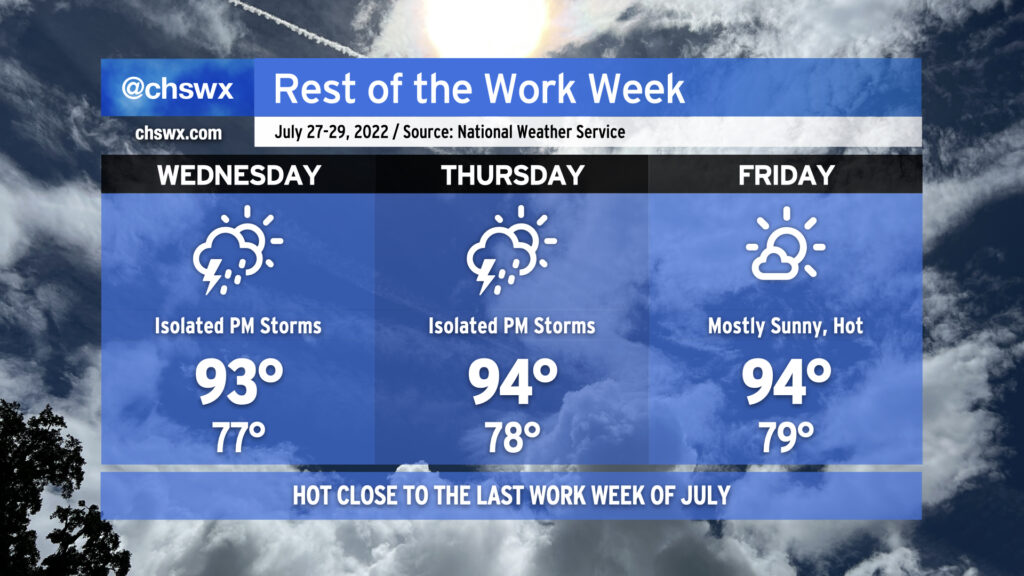
We’ll be closing out the last work week of July with a good bit of heat as high pressure dominates the weather pattern. Air temperatures will run into the mid-90s each afternoon, while humidity on top will make it feel well into the mid-100s. While heat indices will not reach the post-July 1 heat advisory criteria of 110°, it’ll still be enough to elevate the risk of heat-related illness. Make sure you’re getting plenty of fluids and taking plenty of shady breaks during the heat of the afternoon if you must be outdoors. Low temperatures will run quite warm as well, only bottoming out in the upper 70s away from the coast. Downtown and coastal communities may not see lows dip below 80° for several days. This lack of any real cooling off can add to cumulative heat stress over time.
The aforementioned high pressure will keep afternoon showers and thunderstorms to a minimum, with only isolated coverage expected along and ahead of the seabreeze on Wednesday and Thursday, with unmentionably low rain chances on Friday. It’s hard to stay totally rain-free this time of year, but don’t expect much out of storms over the next few days.
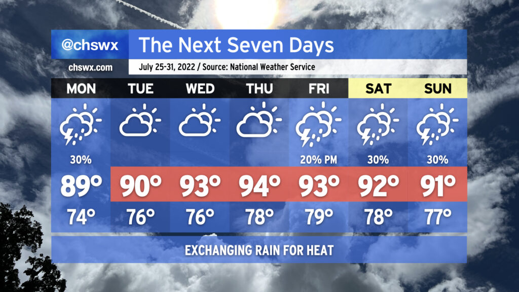
We saw a lot less rainfall across the area today as ridging began to take hold. This continues into tomorrow and for much of the rest of the week as high pressure strengthens and maintains its grip. Highs will top out in the low 90s; mix in some humidity and you’ve got yourself heat indices in the low 100s.
Rain-wise, there’s not too much to write home about: We’ll have a shot at a shower or storm or two in the morning along the coast, but much of that activity should remain largely offshore. An isolated storm or two cannot be totally ruled out in the afternoon; where a storm fires, the rain could turn heavy and winds could be briefly gusty. However, the vast majority of us should stay dry. Expect this pattern to largely repeat itself for the rest of the work week, too, just with warmer air temperatures contributing to heat indices eventually reaching 105-110° by Wednesday and Thursday.
The good news is that there are some predominantly rain-free days in the forecast this week. (Imagine writing that three weeks ago!) The less-than-good news is that temperatures will head back up, with heat indices perhaps approaching 110° later this week before a slightly more unsettled pattern returns for the weekend.
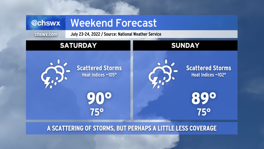
Hot and humid conditions continue this weekend as temperatures head back to around 90° each afternoon. Mix in the humidity and it’ll feel closer to 105° on Saturday and 102° on Sunday. Scattered showers and thunderstorms will remain in the forecast primarily in the afternoons, with the risk for locally heavy rain and isolated bouts of flooding to continue. A stronger storm or two with gusty winds is certainly on the table, as well. Lightning will make every thunderstorm dangerous, so remember to head indoors if you’re hearing thunder. Overall, with high pressure beginning to reassert itself, we should see a little less coverage of showers and storms overall. Storms will certainly not be an all-day thing — just something to plan around.
We turn progressively warmer and less rainy (finally!) next week as high pressure continues to build in at the surface and aloft. Mid-90s will be common by Wednesday, with isolated to scattered storms along and ahead of the seabreeze possible each afternoon. But that’s next week; no reason to prematurely induce Sunday Scaries. Enjoy the weekend!
More steamy and occasionally stormy weather is in store for the weekend as a cold front moves close by and stalls out. It won’t be a total rainout, but backup plans for weekend activities are not a bad idea.
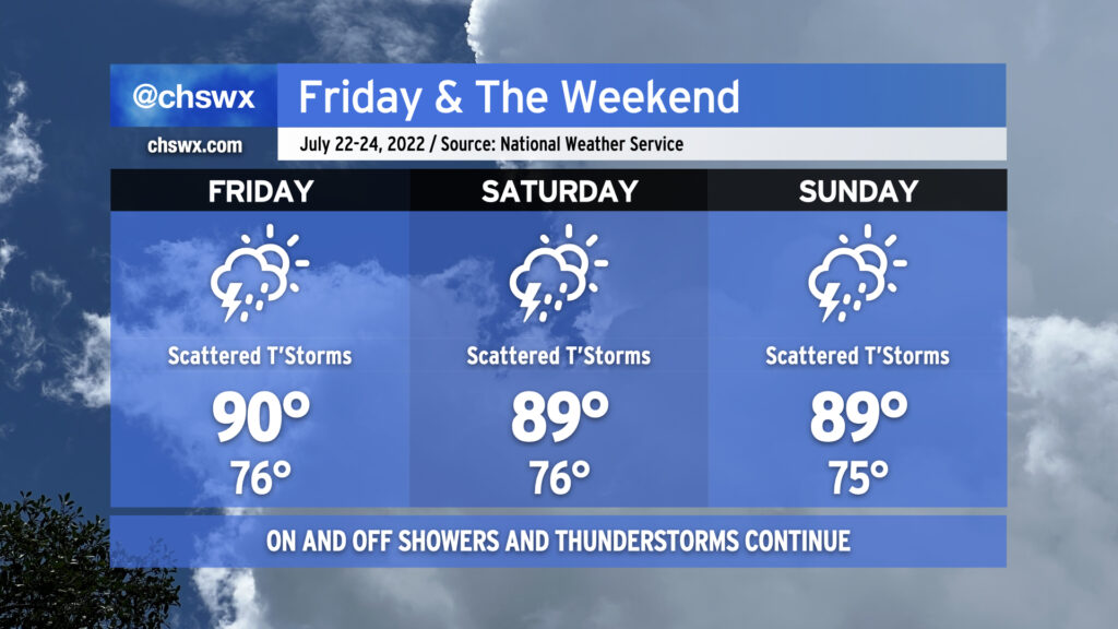
Friday should start out rain-free in the metro area, but it’ll still be quite warm as we start In the mid-to-upper 70s, warmer toward the coast. Temperatures should rise to around 90° by early afternoon before thunderstorms develop. Humidity will make it feel closer to 103°. Once again, there’s a risk for very heavy rain with these storms, and given the soaking we’ve had recently, flooding is once again a concern.
And so it will go heading into the weekend, as well, with the stalled front acting as a focal point for additional showers and thunderstorms to develop around the area. Temperatures will, before thunderstorms mess things up, top out around 90° each day, with heat indices reaching into the 100s. Heavy rain and flooding remain a threat; a wet microburst with damaging wind gusts can’t be ruled out in the strongest storms, either.
There is change coming, though. We’ll see high pressure begin to reassert itself both at the surface and aloft. This will help to suppress the more widespread thunderstorm activity we’ve seen for the balance of this month as we head into next week, though it won’t eliminate it completely as an isolated shower or storm will be possible along and ahead of the seabreeze. Temperatures, though, will continue to generally run in the low 90s each afternoon, with heat indices continuing to run in the low 100s. And so, summer rolls on. (At least the tropics remain quiet!)
We’ve got another warm, steamy day ahead on Thursday with the potential for heavy afternoon thunderstorms once again affecting the area. Temperatures will start in the mid-70s once again, and your glasses (sun or otherwise) will almost certainly fog up when you walk outside in the morning. Temperatures should rise to the low 90s by early afternoon, and when you factor in the humidity, it’ll feel closer to 105-106° or so — certainly stifling heat that’ll require precautions against heat exhaustion or heat stroke if you must be outside tomorrow afternoon.
Attention will then turn to the threat for showers and thunderstorms. The seabreeze may once again be the culprit for at least an initial round of storms, while west-northwest flow aloft will be monitored closely for any thunderstorm complexes that can develop and push our direction. The seabreeze should have an easier time moving inland tomorrow than it did today, but it could still face some resistance and stay pinned closer to the coast. We’ll want to watch the seabreeze’s inland progression carefully; the lack of such progression today, with storms firing along it and then training heavy rain in the same places, led to 2″ of rain in a little over an hour in spots and resulted in yet another urban flooding event in downtown Charleston. If storms get going, they’ll have plenty of moisture to work with, as precipitable water values continue to be in the 2-2.2″+ range. Hopefully we won’t see a repeat of today — odds are, we won’t — but we’ll keep an eye on it regardless.
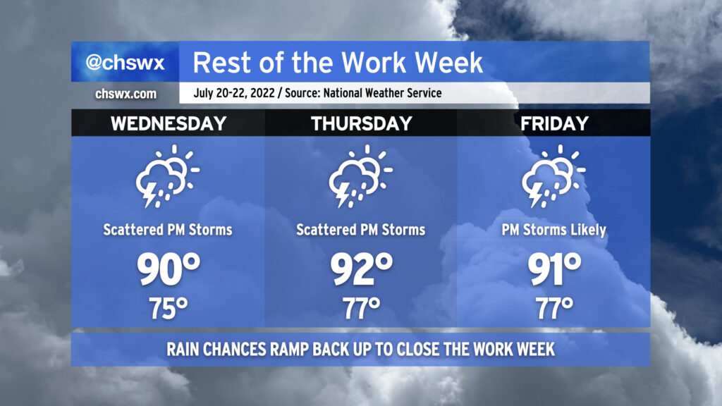
Our warm and occasionally stormy pattern stays in place of the rest of the work week as we remain under the influence of a broad trough aloft. Wednesday will yield another stormy afternoon with a low-end severe weather risk as a disturbance in the mid-levels moves across the Carolinas; if a storm turns severe, damaging wind gusts would be the main issue. Otherwise, it’s another hot and humid day — highs top out around 90° in the afternoon with heat indices once again peaking around 100-102° before storms develop and disrupt the temperature curve.
Thursday should run a little quieter with a little less mid-level energy in play, but we’ll still see the usual spate of isolated afternoon showers and thunderstorms along and ahead of the seabreeze. Temperatures will run a little warmer Thursday, with air temperatures in the low 90s and associated humidity yielding heat indices running around 105° in the afternoon. A cold front will sink southward toward the Carolinas on Friday; this will make showers and thunderstorms in the late afternoon and evening hours a little more likely. Temperatures on Friday continue in the low 90s with heat indices in the low to mid-100s.
Rain chances look to taper off as we get into the weekend, with scattered storms possible Saturday and more isolated storm coverage than we’ve seen in a little while expected on Sunday. It’ll stay muggy with lows in the mid-70s and highs in the low 90s each day.
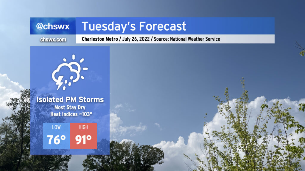
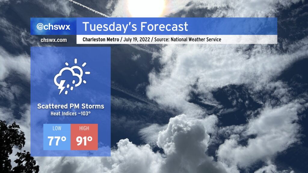
Tuesday will be another steamy July day in the Lowcountry. We’ll start the day in the mid-to-upper 70s in much of the metro area, while the beaches and downtown may very well not get below 80°. Highs will climb into the low 90s; mix in the humidity and it’ll feel closer to the low 100s. Unlike the past few days, showers and thunderstorms should hold off until the afternoon. As always, a strong storm or two can’t totally be ruled out, with wet microbursts a possibility. More broadly, though, heavy rain will be possible as precipitable water values remain around 2”, and ample amounts of energy will be conducive to lightning-laden storms.
We’ll stay in the 90s for much of the rest of the week, with heat indices approaching 105° at times. Scattered afternoon showers and storms will be the rule, with perhaps a little uptick in activity heading toward Friday as a front approaches the area.
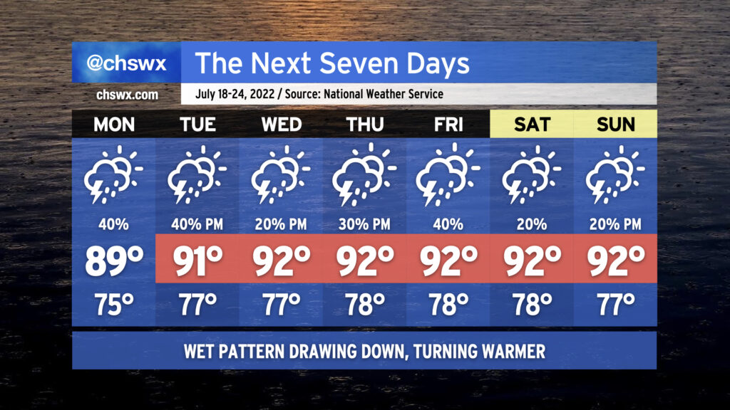
We will begin to see the widespread rain that’s punctuated the first half of July draw down a little bit this week as ridging aloft nudges back into the area. We’ve still got a couple days of periodic showers and thunderstorms to come, with another round of morning rain possibly in the cards for Monday, but overall the trend is a little drier. Of course, this is July, so nobody wins — we trend a little drier, and so temperatures trend a little more upward as the ridge builds overhead. Highs in the low 90s will be common, and with stifling humidity looking to continue, heat indices should be well into the 100s and may breach 105° several times this week. (The heat advisory criteria beginning July 1 is a heat index of 110° for two hours, so that’s why there’s no mention of Heat Advisories right now.) When storms do fire, they’ll be capable of dropping some heavy rain. Widespread severe weather isn’t expected, but you can never rule out a microburst or two this time of year. Overall, fairly standard mid-July fare is anticipated. Stay cool as best as you can — remember, frequent shaded breaks, lots of water.