Jared Smith founded @chswx on Twitter in 2008 as an experiment in disseminating weather data through social media. In the ensuing decade-and-a-half, @chswx has provided live coverage of tropical cyclones, tornadoes, severe weather, and even a couple bouts of winter weather to the good people of Charleston, SC.
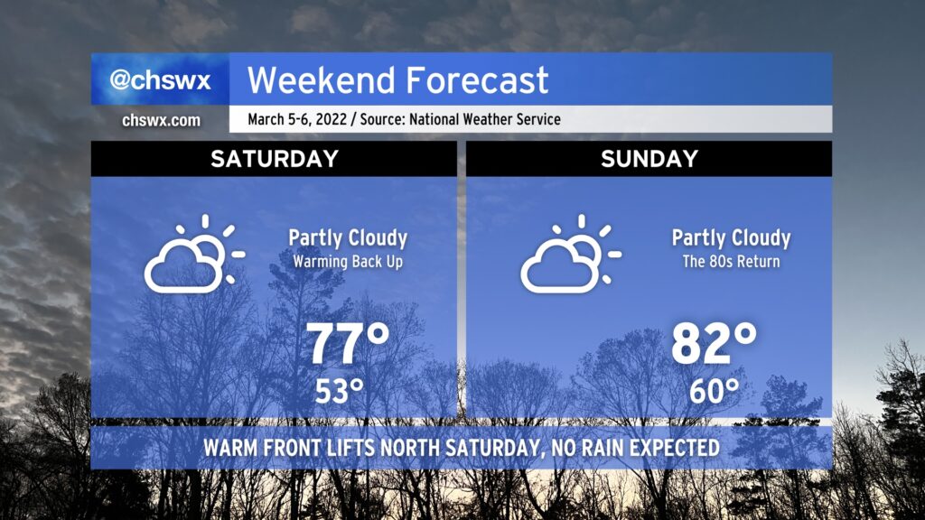
After a brief interlude on Friday thanks to a cool wedge of high pressure building into the area, warmth and sunshine returns Saturday as the front lifts back northward as a warm front. Like the cold frontal passage last night, we’ll remain rain-free as the warm front lifts northward.
With the wedge airmass out of here, temperatures jump back to the mid-to-upper 70s by Saturday afternoon, and we’ll warm even further toward the low 80s on Sunday. The record high for March 6 is 85°, and we might get within spitting distance depending on how much heating can develop.
Warm weather will continue into Monday with near-record highs possible again. Beyond that, things take a turn for the unsettled for much of the next work week with temperatures running a little cooler (but still above normal).
We set a record high today at downtown Charleston: 80° broke the record of 79° set in 1976. We’ll get a brief interlude in the warmth Friday as high pressure wedges southward across the area, turning winds more northeasterly and kicking up the cloud cover to keep temperatures running about 15-20° cooler than we saw today. Moisture is scant, though, so no rain is expected — we’ll just be chilled out briefly before the wedge front lifts northward on Saturday, returning us to the 70s and 80s for the weekend. We remain rain-free through Tuesday before the pattern turns more unsettled as we get deeper into the next work week.
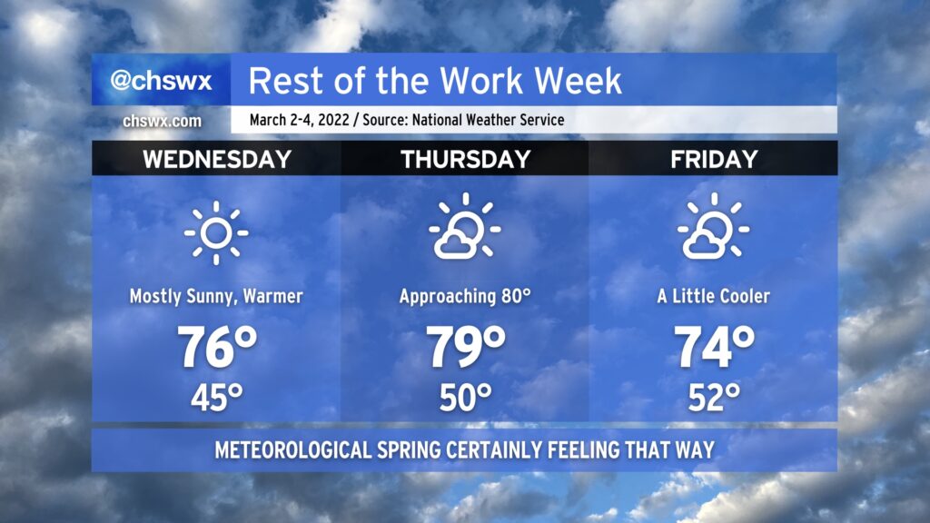
After topping out around 70° today, temperatures will aim ever warmer for Wednesday and Thursday before a dry cold front knocks temperatures down a bit for Friday. Mostly sunny skies will be the rule throughout, and with winds more out of the west, the risk for coastal flooding will decrease, too. Weather looks to get even warmer as we get into the weekend, too, with rain chances maybe returning to the forecast next Tuesday.
We’re getting close to the last freeze dates of the season (the median last freeze at North Charleston is March 8), but we can still have bouts of freezing temperatures well into early April, so be cautious if you begin planting. To that end, though, the National Weather Service has restarted the frost and freeze program as of today, which means Frost Advisories and Freeze Warnings will once again be issued by the NWS office when conditions become questionable for vegetation. If those end up being needed at any point, I’ll pass them on.
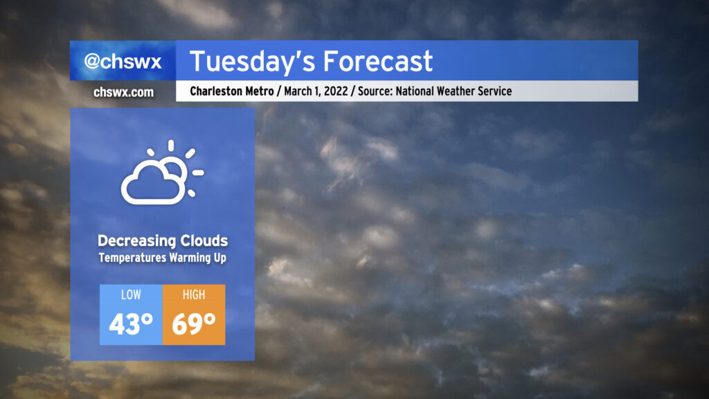
Tuesday looks to be a rather nice day across the area as early cloud cover moves away in the afternoon, yielding temperatures in the upper 60s to around 70° as more sunshine begins to filter in. High pressure will be building in and taking residence over the area for several days, which will keep fair and increasingly warm weather in the forecast as we kick off meteorological spring, which runs from March 1 to May 31.
The only weather-ish concern will be the risk for some minor coastal flooding with the ~7am high tide Tuesday. Water levels could peak around 7.0-7.2′, putting some salt water on vulnerable roadways particularly on the western side of the peninsula near the Joe and MUSC. Any flooding should be relatively short-lived, and with winds shifting offshore after tomorrow, the risk for coastal flooding will end just as quickly as it arrived.
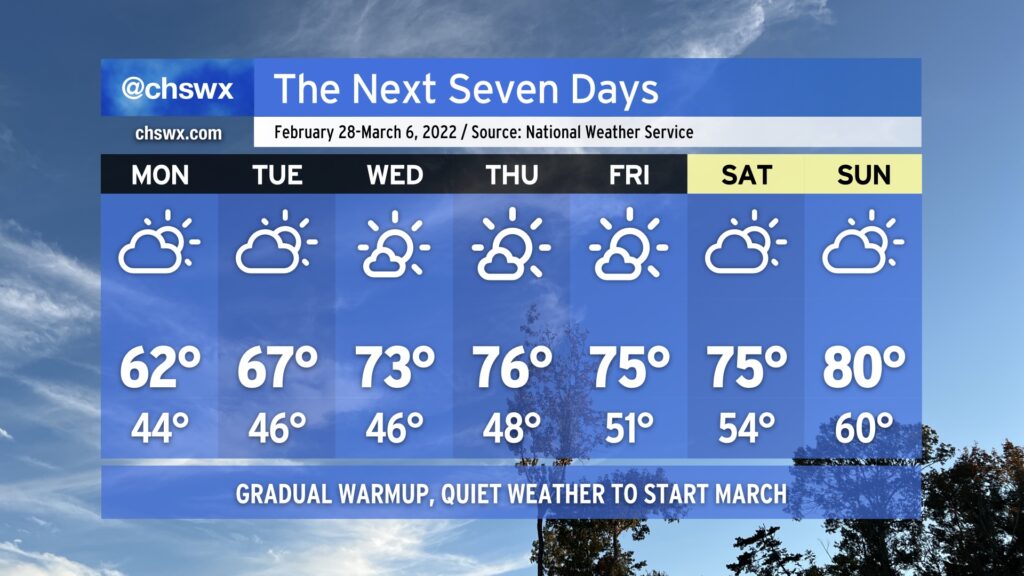
February gives way to March this week with very little fanfare in the weather department. We start the week with temperatures running a touch below normal, but a gradual warmup is in the cards as we get through the work week before we approach 80° by the weekend. High pressure will keep things rain-free for the next few days, though it may be a little more cloudy than we might like Monday into Tuesday.
The only main weather concern this week will be the risk for minor coastal flooding with the Monday and Tuesday morning high tides thanks to persistent northeast flow and the upcoming new moon. The 6:03am high tide Monday morning could clip 7’. Tuesday morning’s will run a little higher around 7.2-7.4’, which could close a few vulnerable roads near the edges of the Charleston peninsula. Beyond then, winds begin to go around to the north and then the west, which will cut down the coastal flooding risk for the rest of the week.
Keep rain gear handy for the rest of today as we get into the afternoon and evening hours. Light showers are already beginning to break out across the area, though the bulk of the rain remains — for now — to our north and west. Expect this to continue to fill in as the day goes on, with the best chance of showers later this afternoon into this evening. Temperatures will top out around 60° given cloud cover and showers in the area.
We’ll run a little cloudier and cooler on Sunday as increased moisture and an approaching upper-level system come together across the area. There will be some breaks in the clouds from time to time to let some sun peek through, but overall expect highs to top out in the low-to-mid-60s. Rain should hold off until after dark when the best ingredients pass by, though, so you should be able to get at least a fair bit of Sunday in rain-free. If you’ve got outdoor activities in the afternoon and evening hours, monitoring radar trends for a few showers is a good idea, but there are no other major concerns with the forecast.
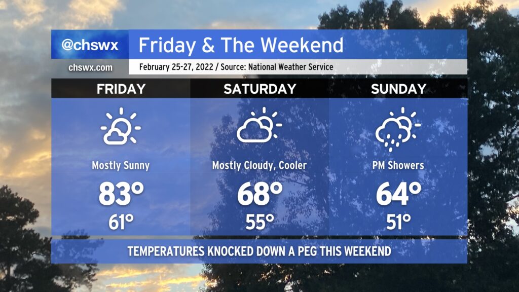
For the third consecutive day, we at least tied the record high at Charleston International Airport. Today’s high was 86°, which matches 2018’s record temperature. Changes are coming, though, thanks to a cold front which will bring this run of record highs to an end.
Temperatures on Saturday should run some 10-20° cooler in spots in the wake of the aforementioned cold front. The front itself will come through dry, but expect an uptick of cloud cover behind it on Saturday. Highs in the mid-60s will be common (and much closer to where we should be at this point in the year).
Unfortunately, this weekend doesn’t get in rain-free; expect showers to develop starting Sunday afternoon as an upper-level disturbance ripples through. Highs will top out in the mid-to-upper 60s across the area, though showers could put a damper on that later in the day.
Heading into next week, temperatures will remain around if not a few degrees above normal — though certainly nowhere near the record levels we experienced this week. All in all, above-normal temperatures remain strongly favored as we head into March, but never underestimate the power of one last March freeze to cause problems to start the growing season.
For the second straight day, we reached a record high at the airport as the temperature peaked at 84° a little after 2:30 PM. This broke the previous record high of 83° set in 2018. (The normal high for this point in February is 66°.)
The early evening surface analysis showed a wedge front stalled out roughly north of I-20. Ahead of that front, temperatures were in the upper 70s to low 80s. Behind that front, temperatures were in the 60s and below! This front is not going to make it this far south for tomorrow, though, which will allow Friday’s temperatures to once again soar into the 80s under partly cloudy to mostly sunny skies. The record high of 86°, set in 2018, will bear watching.
Patches of fog will be possible in the morning, so be ready for brief disruptions in visibility during your Friday morning commute.
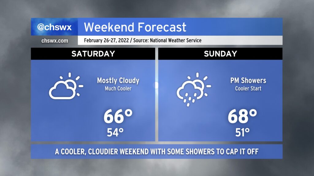
By Friday evening, though, the frontal zone will be moving through the area, yielding a much cooler weekend. Temperatures on Saturday will struggle to the upper 60s under partly to mostly cloudy skies. (68° is still a couple degrees above normal for this point in the year, though.) On Sunday, a few showers will be possible as a disturbance passes by overhead. We’ll run a few degrees cooler with highs generally topping out in the mid-60s in the afternoon.
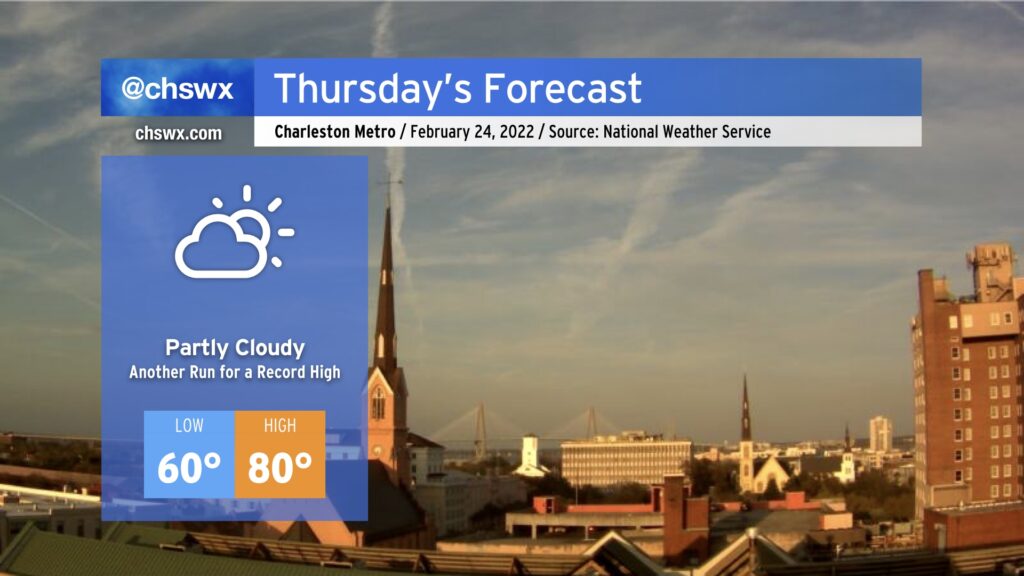
Wednesday was a very unusually warm February day in the Lowcountry. The high of 86° handily obliterates the daily record for February 23 of 82° set in 2018, but today also marked just the fourth time since records began in 1938 that the high temperature reached 86° in February. Previously, this happened on February 25, 2018, February 16, 1989 (when the high was 87°, setting the all-time February record), and February 28, 1962.
We look to take another trip into the 80s tomorrow. While surface flow coming a touch more off the Atlantic may modulate temperatures a bit, it is still certainly possible we may at least tie the daily record of 83° set in 2018. Fog may be a greater issue tonight and tomorrow morning, though, with lighter winds making for more favorable conditions for fog development. This fog could be dense, so be ready for visibility restrictions as you commute Thursday morning. The slightly more onshore trajectory could also help spread sea fog inland later in the day, which would have a chilling effect on temperatures as well. As usual with our weather, there’s so many variables to watch, even when there’s no precipitation involved. But regardless, prepare for another absurdly warmer-than-normal February day.