Jared Smith founded @chswx on Twitter in 2008 as an experiment in disseminating weather data through social media. In the ensuing decade-and-a-half, @chswx has provided live coverage of tropical cyclones, tornadoes, severe weather, and even a couple bouts of winter weather to the good people of Charleston, SC.
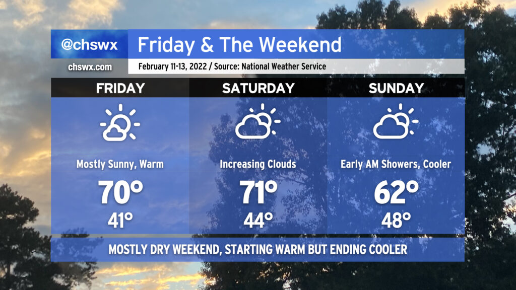
After an absolutely gorgeous day today, we’ve essentially got a repeat on tap for Friday as high pressure remains in control of our weather. Temperatures will once again top out right around 70° with low humidity continuing. Try to get outside if you can!
Saturday may actually run even a touch warmer, but increasing cloud cover will portend changes coming to the area as a cold front approaches the area Saturday night. Right now it looks to come through sometime Sunday morning, which should act to knock high temperatures down around 10° from the previous day. Even colder air will arrive for Valentine’s Day, but temperatures look to moderate back to spring preview levels as next week goes on. Overall, it looks like we’re going to end February on a warmer note, and that isn’t too shabby considering the pretty chilly stretch we’ve been in over the last month or so.
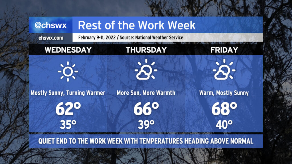
After a couple really dreary days across the Lowcountry, we will finish the balance of the work week with much more sunshine as high pressure builds into the area from the southwest. This’ll not only help clear us out, but the westerly winds will help temperatures moderate as well, with temperatures heading a few degrees above normal to close out the week.
Wednesday may start with some patches of dense fog across the area, with a better risk of fog found inland of 17-A. We’ll want to watch surface temperatures closely, as some spots well inland could be at risk of some freezing fog overnight into tomorrow morning, potentially producing some slick spots on bridges and overpasses near the I-95 corridor. This does not appear to be a concern for Charleston proper, though. If they do form, any slick spots will not last terribly long after sunrise as temperatures quickly head into the 50s before peaking in the low 60s in the afternoon.
From there, the airmass will continue to moderate, allowing for highs in the mid-60s on Thursday and the upper 60s on Friday under mostly sunny skies. We’ll start those days generally around 40°, too, which is right around normal for this point in the year. All in all, not too shabby to close out the work week. Looks like we get Saturday in rain-free, too, but with a few more clouds before rain chances kick back up Sunday as a frontal system moves by.
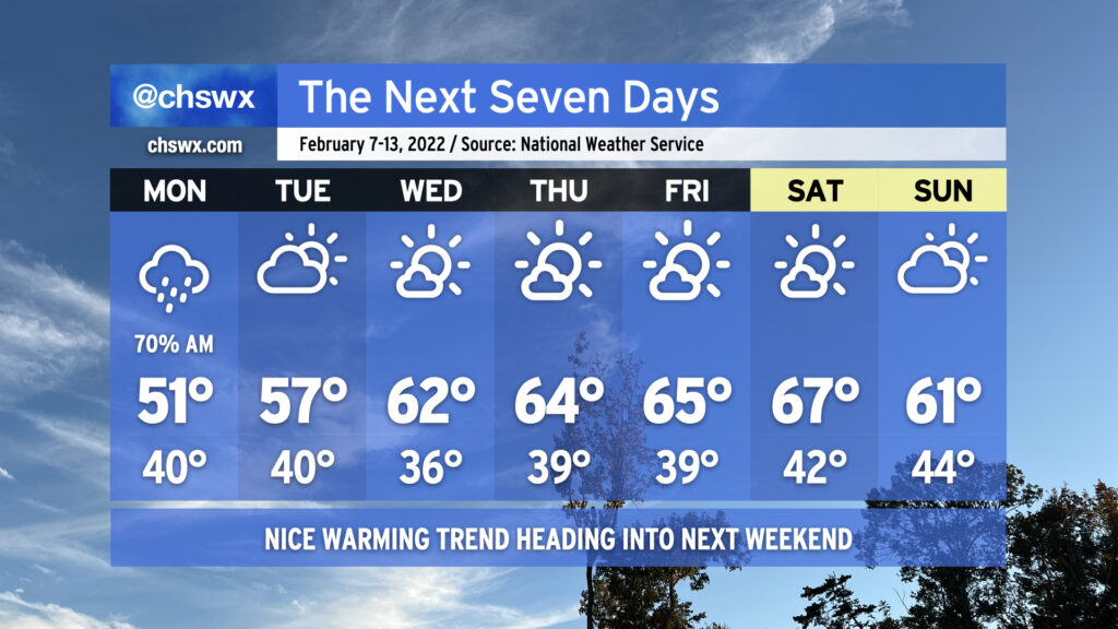
This week’s forecast is largely straightforward and gets better as the week wears on. We’ll get much of the rain out of the way Monday morning, with shower chances diminishing heading into the evening as coastal low pressure departs. Monday’s going to be the chilliest day of the set with highs struggling to crack 50° thanks to the showers and persistent cold wedge.
Cloud cover and maybe a shower or two will linger to start Tuesday, but we’ll be trending clearer as the day goes on. Highs top out in the mid-50s. From there, temperatures begin to trend at or even above normal with several days of quiet weather on tap from Wednesday to at least Saturday if not beyond. There is a little model noise around some rain in the area by next Sunday, but agreement and consistency is meh at the moment. For now, the NWS forecast maintains dry but slightly cooler weather for Sunday. We’ll keep an eye on that in case it changes!
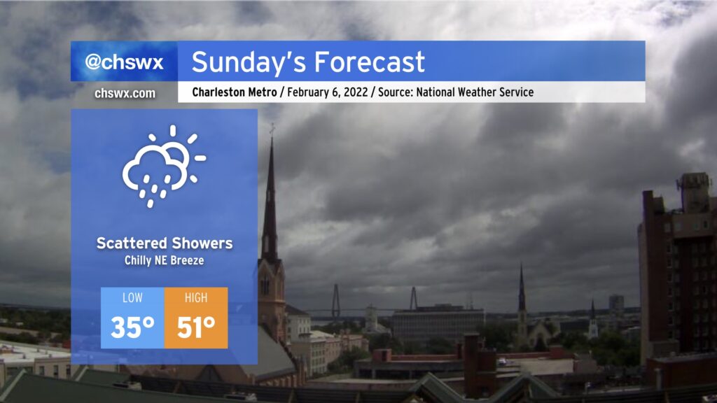
After a sunny respite on Saturday, clouds and showers are returning to the forecast for Sunday into Monday as moisture lifts atop a southward-building wedge of high pressure and a trough of low pressure sets up along the coast. Expect showers to develop mostly offshore overnight into early Sunday, with the best chance for any showers to be found near the coast. Many of us could stay dry until Sunday evening, when low pressure developing offshore begins to send more precipitation northward and westward. This feature will keep precipitation in our forecast into much of Monday as well.
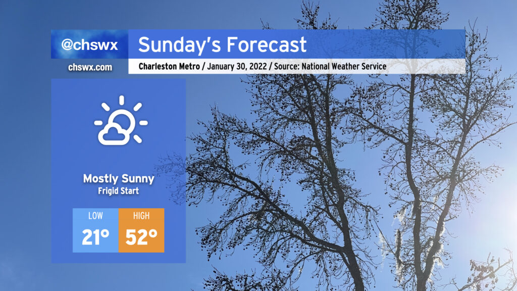
Sunday’s going to remain pretty chilly as the wedge builds southward amidst a persistent northeasterly breeze. We’ll start the day in the mid-30s with wind chills dipping into the 20s. Cloud cover will inhibit much in the way of warming, with highs only looking to top out in the low 50s in the afternoon.
While it will certainly feel like there should be frozen precipitation, the good news is that the airmass is just not cold enough to accomplish that. Why is this good news, you ask? Because in these kinds of setups, the most likely frozen precipitation type would be freezing rain. (Gross.)
Hang in there through tomorrow and Monday, though — the rest of the week looks to be rather nice, with temperatures near normal and decent sunshine as high pressure builds in.
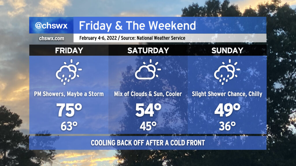
Our spring preview has one more day to go before a cold front comes through later Friday and knocks temperatures down quite a bit for Saturday. We’ll see rain chances head up as we head into Friday afternoon and evening, with even a chance for a rumble of thunder or two. Instability will be lacking, but the shear should be enough to support a couple thunderstorms. It won’t rain all day, though, with the best chances around dinnertime.
We turn much cooler Saturday in the wake of said cold front. We’ll see a brief round of clearing on Saturday before a coastal low develops near Florida and heads northeastward, helping to drive a wedge of cooler air southward and keeping a shower chance around near the coast for much of the day. (That being said, it will not rain all day at any one location, either!) Temperatures may not get out of the upper 40s on Sunday. The good news? No sub-freezing temperatures are in the forecast, thus there are no winter weather concerns.
Despite winds going back around to the northeast later Saturday into Sunday, we’re far enough removed from the perigean spring tide where coastal flooding doesn’t look to be a concern for the weekend. It’s been an active year for coastal flooding already, with 11 events in 2022 so far, and we’re just into February 3rd. This already beats 1998’s total of ten coastal flooding events in that year’s first two months.
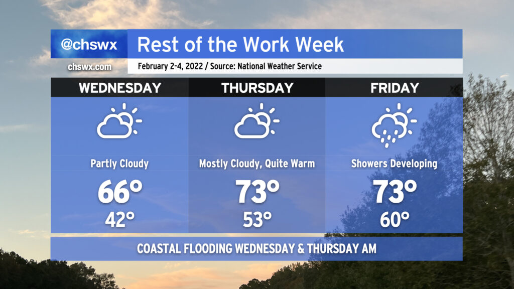
Thursday will offer up an early taste of spring as breezy southerly winds ahead of our next cold front pump warm air into the area. After starting the day in the mid-50s — keeping in mind the normal high for early February is 62° — temperatures will head into the 70s in the afternoon under a mix of clouds and sun. Some of the high-resolution guidance members do show a stray shower or two in the area, but a mostly dry atmospheric column should keep those few and far between.
As mentioned before, it’ll be breezy: southerly winds could gust to about 20 MPH or so at times during the day, so keep this in mind if you’re thinking about an outdoor lunch.
There remains an outside shot at some coastal flooding again Wednesday morning, but the more southerly flow should help keep any tidal flooding relatively minor. Still, watch out around the 9:39 AM high tide for a few salt water-covered roads in vulnerable spots, particularly near MUSC and The Citadel.
Our warming trend continues as we head toward Friday before a cold front gets by and knocks Saturday back to normal. Wednesday features partly cloudy skies and highs topping out in the mid-60s, while we go even warmer on Thursday — low 70s for highs! — despite increasing cloud cover as the cold front draws nearer. By Friday, we stay in the 70s, but expect showers to begin to develop and move across the area ahead of said front. We turn much cooler for the weekend behind the front, and will likely stay unsettled pending the development of a coastal low that will head northeastward, keeping rain chances in our forecast into the new work week.
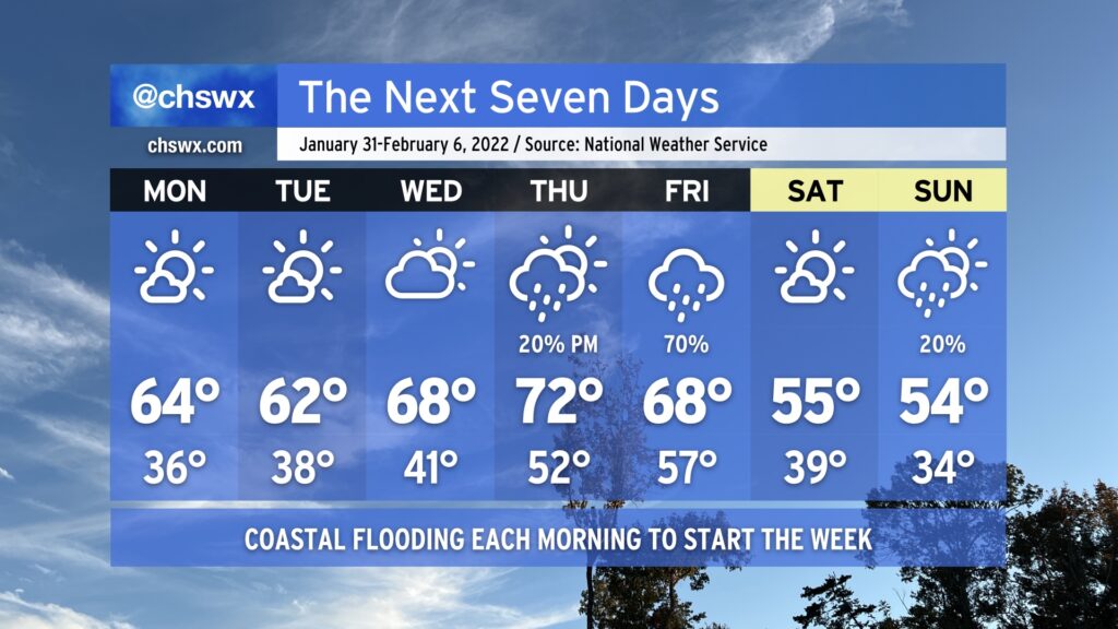
After a couple rather chilly weeks, we’ll give the heavy jackets a bit of a rest as ridging builds in aloft. We start the week with low temperatures in the mid-to-upper 30s and highs in the low-to-mid-60s with plenty of sunshine. Cloud cover ticks up a little bit for Wednesday, but so do temperatures as we get close to 70° in the afternoon. By Thursday, another storm system will be approaching from the west, but we should top out in the low 70s before it starts to get into the area. Right now our best rain chance arrives Friday as the cold front gets through. Saturday will turn much cooler with highs back in the mid-50s. This continues into Sunday, with perhaps a slight rain chance as moisture overruns a wedge of high pressure at the surface.
Sunday morning will be the coldest of the season thus far as lows bottom out in the low 20s in the metro area. I wouldn’t be surprised to see a few spots dip below 20°, even. Suffice to say, this is pipe-busting cold — keep a faucet on drip and make sure your pets and plants are in a warm place tonight. Add on some wind kicking in after sunrise, and temperatures could feel closer to the mid-teens during the morning.
A warming trend will commence, though, as winds go southwesterly during the day Sunday. Temperatures will top out in the low 50s (as opposed to the mid-40s) in the afternoon. We won’t fall below freezing overnight in most locations in the metro area (staying in the mid-30s) as we head into Monday morning, either. From there, Monday could be the warmest afternoon in a week and a half as highs climb into the low 60s for the first time since it was 73° on January 20. We could even see 70s again on Thursday ahead of our next storm system which, thankfully, looks to stay all liquid this go-around.
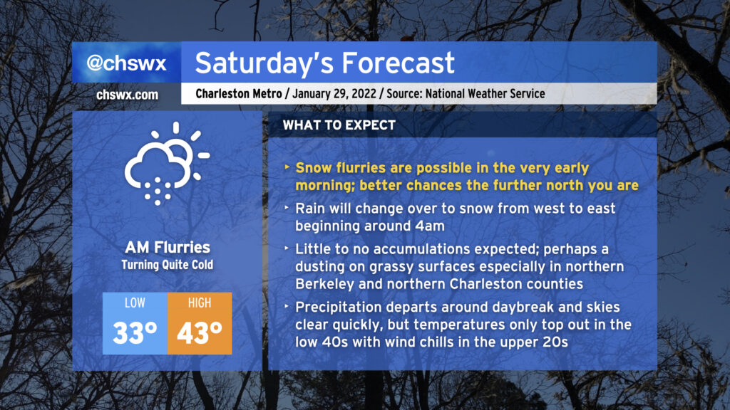
No point in burying the lede: Yes, we do have a legitimate shot at some light snow very early on Saturday morning. If you’re looking for your best chance to see snow, you’ll need to get up pretty early — general thinking around timing the change from rain to snow is generally from 3-5am from west to east.
There’s inherent uncertainty in where flakes will fly. We’re likely to see our best snow in northeastern Berkeley County and far northern Charleston County, where a couple hundredths of an inch could accumulate primarily on elevated and/or grassy surfaces. Further south into the Charleston metro area, precipitation looks to lighten up and taper off as moisture is stripped out of the atmosphere. It’s here where my confidence in whether we even see flurries is lower — a lot will be determined by the path of the upper low over the next few hours. In all cases, though, it is unlikely that we will see any problems.
Precipitation looks to depart generally around daybreak, though the further north you are, the longer it might linger as light snow. Once the snow is gone, attention turns to the surge of Arctic air in the wake of the strengthening coastal low pressure that is going to bring a blizzard to a fair number of people in New England. Highs will only top out in the low 40s, and it’s conceivable that wind chills could be in the 20s well into the afternoon. Air temperatures get that low for Sunday morning as another cold day is on tap before a warming trend evolves beginning Monday.
Let me know what you’re seeing tonight into tomorrow morning if you end up trying to wake up early for this — just make sure you’re bundled up!